.webp?language=en-US)


LONGQUAN MOUNTAIN Park: Earthquake Disaster Mitigation Research
-
This study explores the integration of earthquake early warning and radon monitoring systems within mountain parks to enhance disaster resilience. Focusing on the Longquan Mountain fault zone, it examines how seismic risk assessment and response strategies can be combined with ecological landscape design.
Through a research-driven design approach for Longquan Mountain Park, three key strategies—Mountain Geological Restoration(GRM), Radon Gas Mapping (RGM), and Earthquake Monitoring and Alert Systems (EMA)—demonstrate how green spaces can support disaster mitigation while maintaining ecological and aesthetic value. The study highlights landscape interventions to improve public safety and sustainability in seismic regions.
-
1. INTRODUCTION:
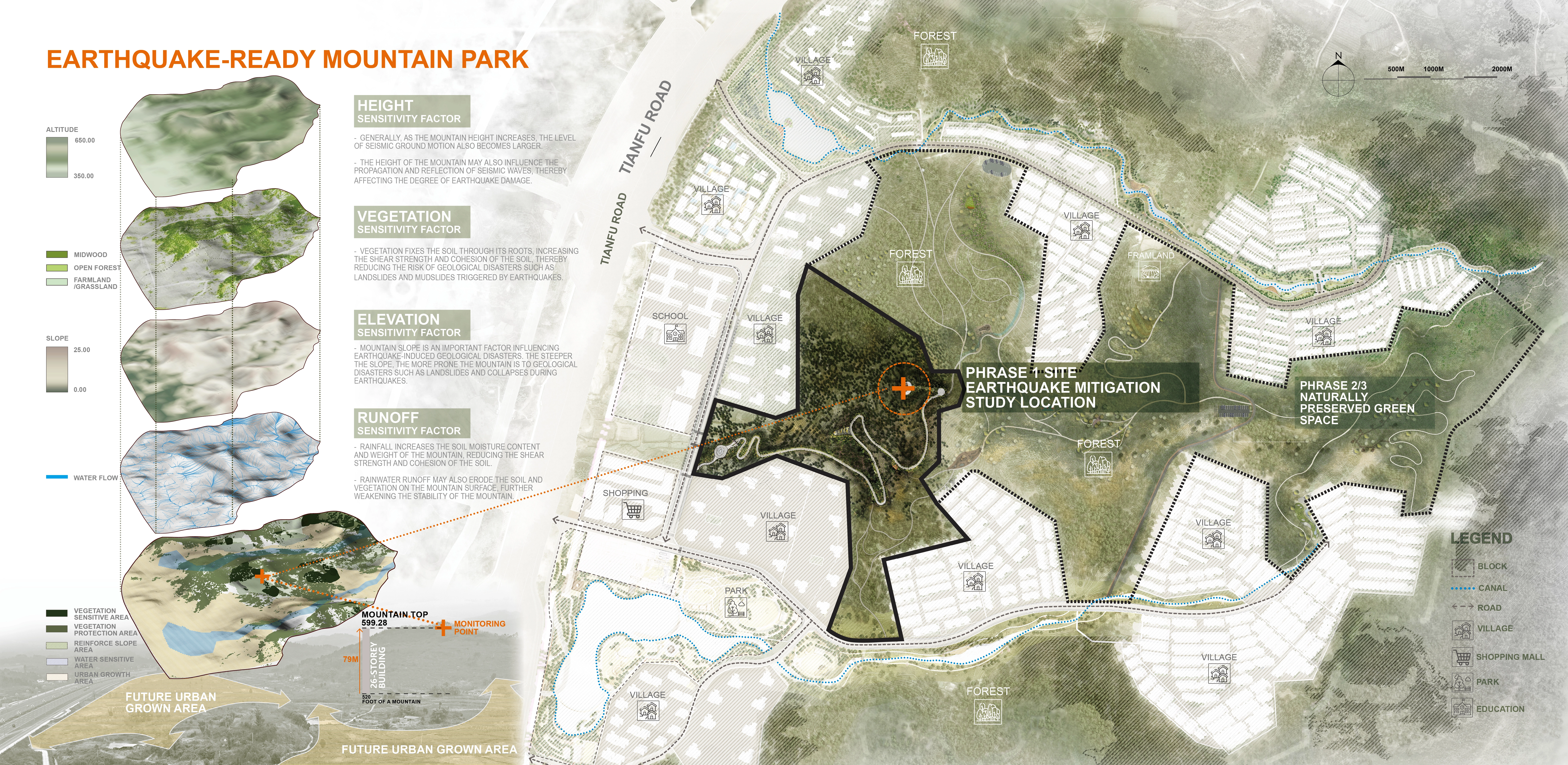
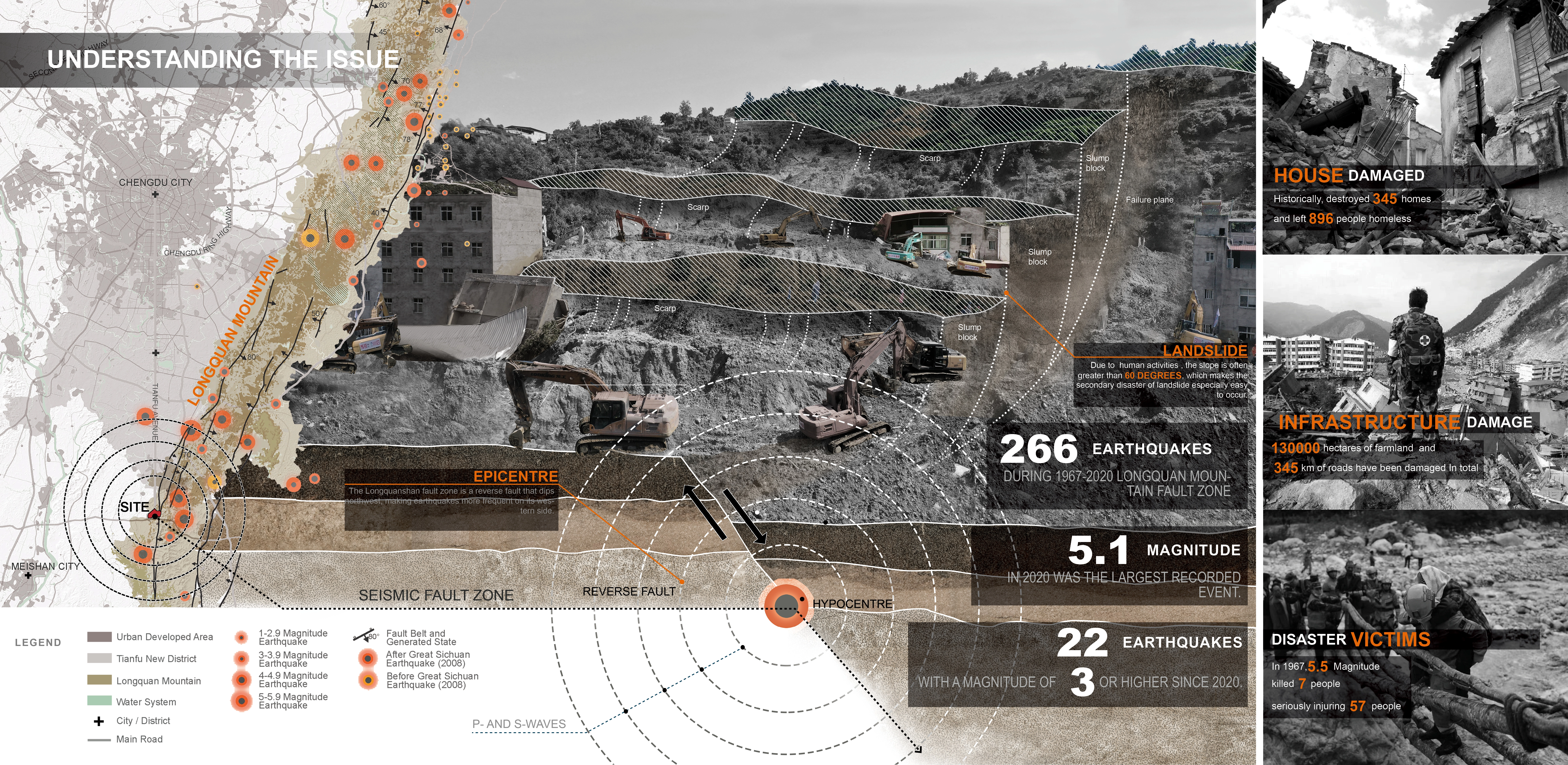
Located in a seismic fault zone in Sichuan, Longquan Mountain Park faces ongoing geological risks and ecological degradation. In response, this study explores an integrated landscape strategy that enhances both disaster resilience and ecological stability. Collaborating with the Chengdu Municipal Bureau of Planning and Natural Resources and Vanke Group, the research team developed a framework that combines seismic hazard mitigation, ecological restoration, and community adaptability. This project transforms a vulnerable site into a sustainable, resilient park, setting a model for innovative landscape planning in earthquake-prone regions.
2. THREE EARTHQUAKE DISASTER MITIGATION STRATEGIES
Through a research-driven design approach for Longquan Mountain Park, three key strategies demonstrate how green spaces can support disaster mitigation while maintaining ecological and aesthetic value.
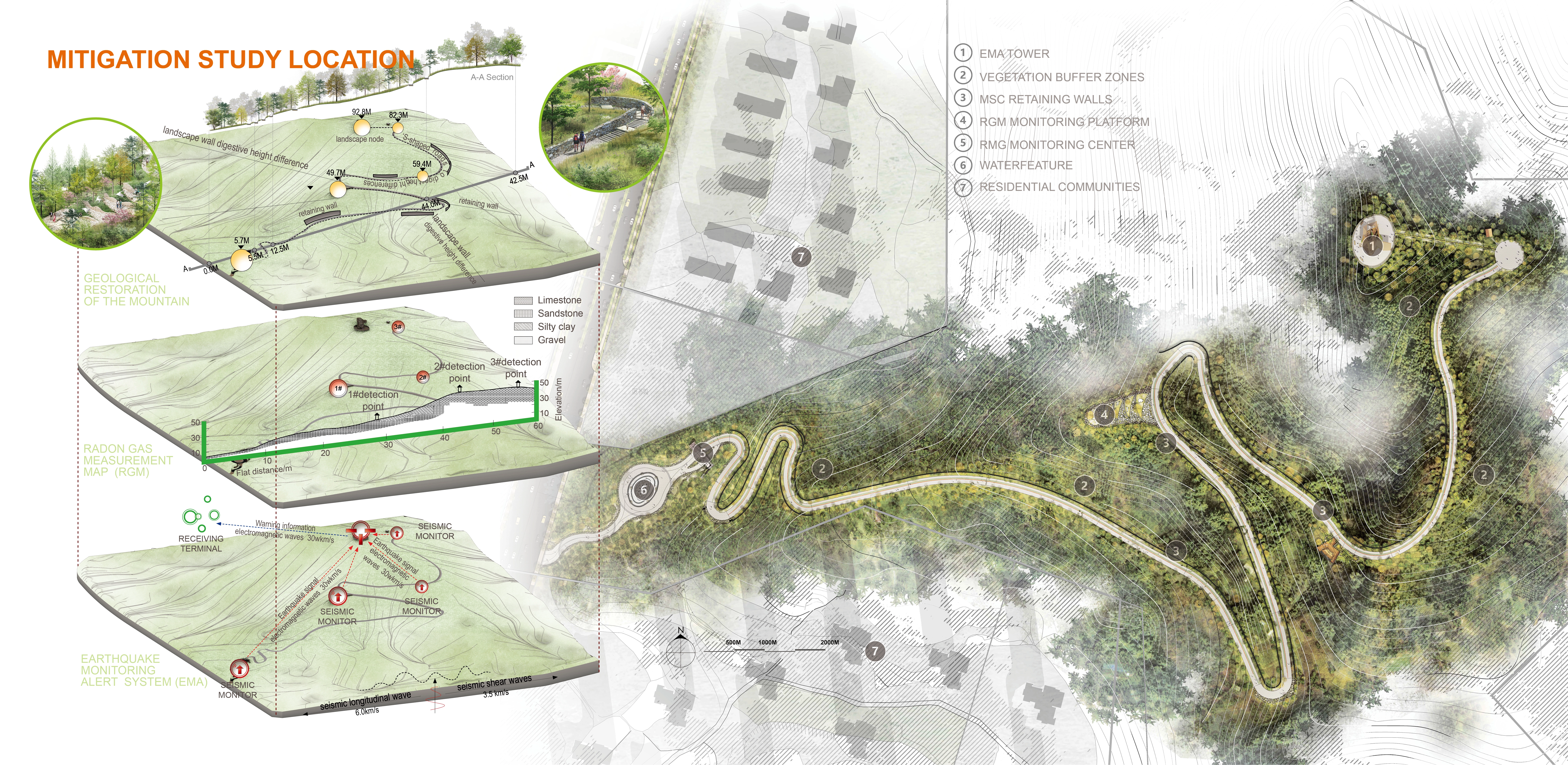
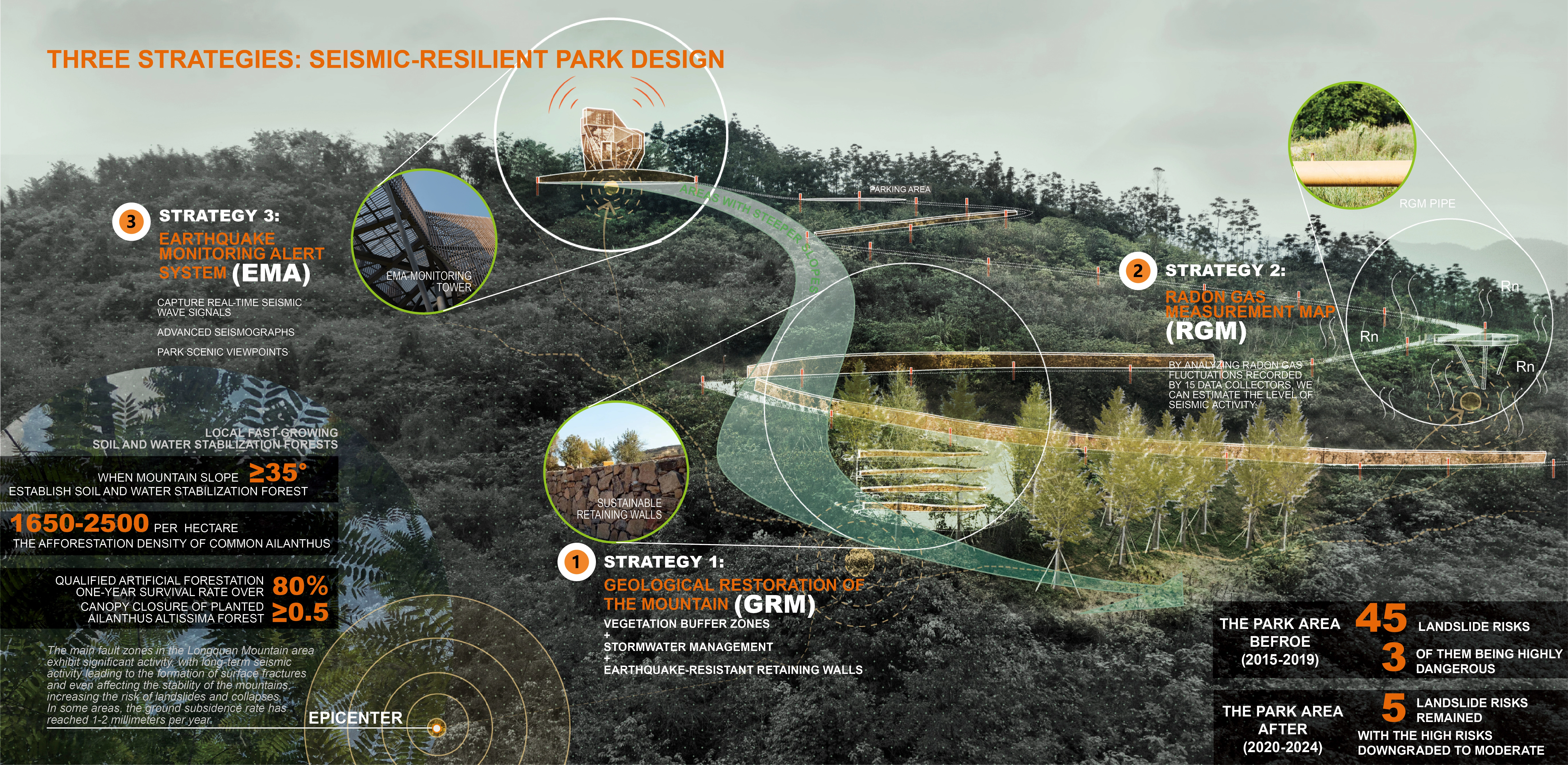
2.1 STRATEGY 1. Geological Restoration of the Mountain (GRM)
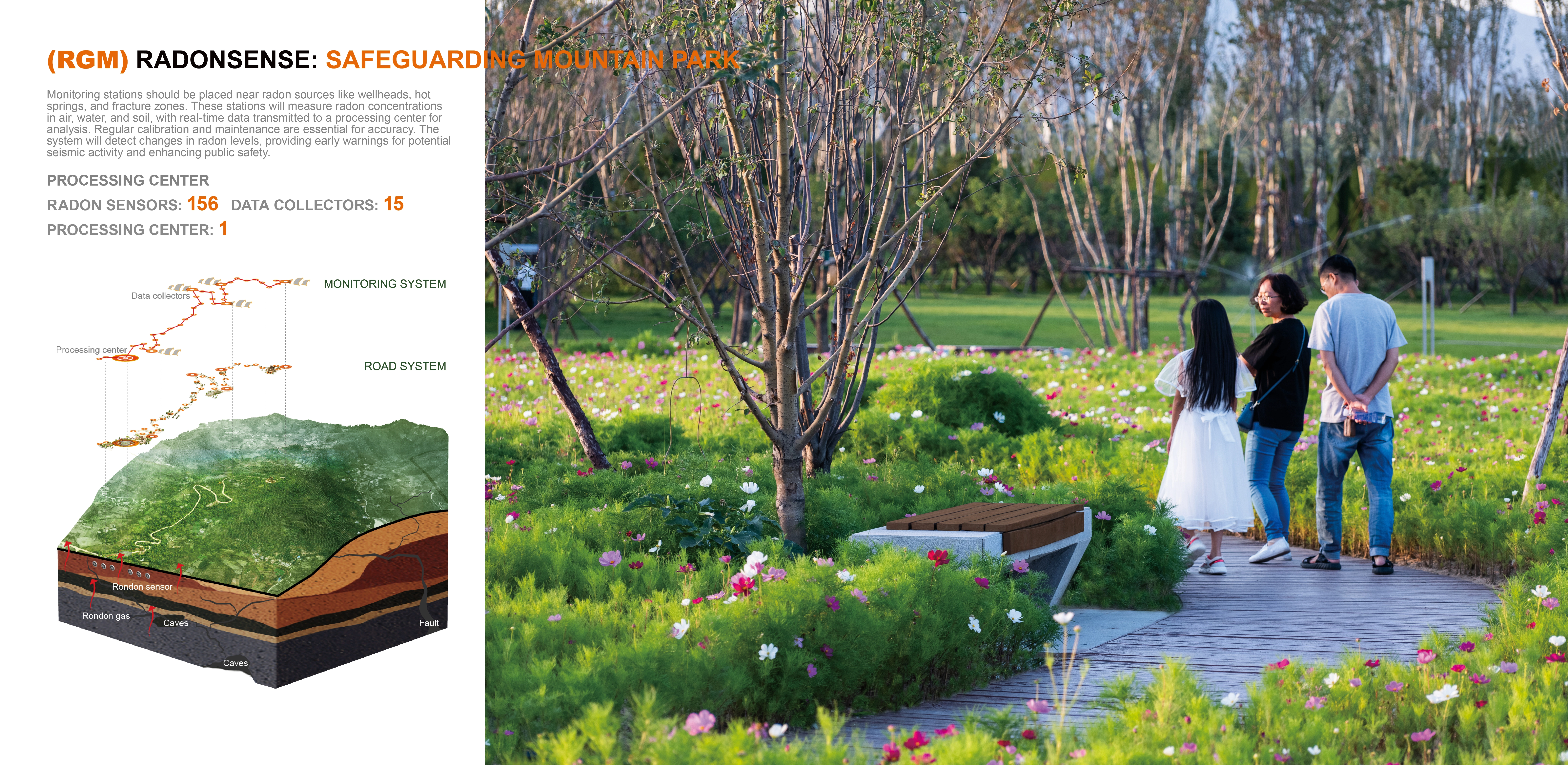
Research reveals that radon fluctuations in seismic-prone regions are key to earthquake monitoring. Integrated along park roads, the Underground Radon Gas Measurement (RGM) system continuously tracks radon fluctuations—key seismic indicators. Data from 15 collectors is processed at a mountain monitoring center, generating real-time, color-coded risk maps for rapid earthquake assessment. Designed to blend into the landscape, this system enhances disaster preparedness while maintaining ecological balance.
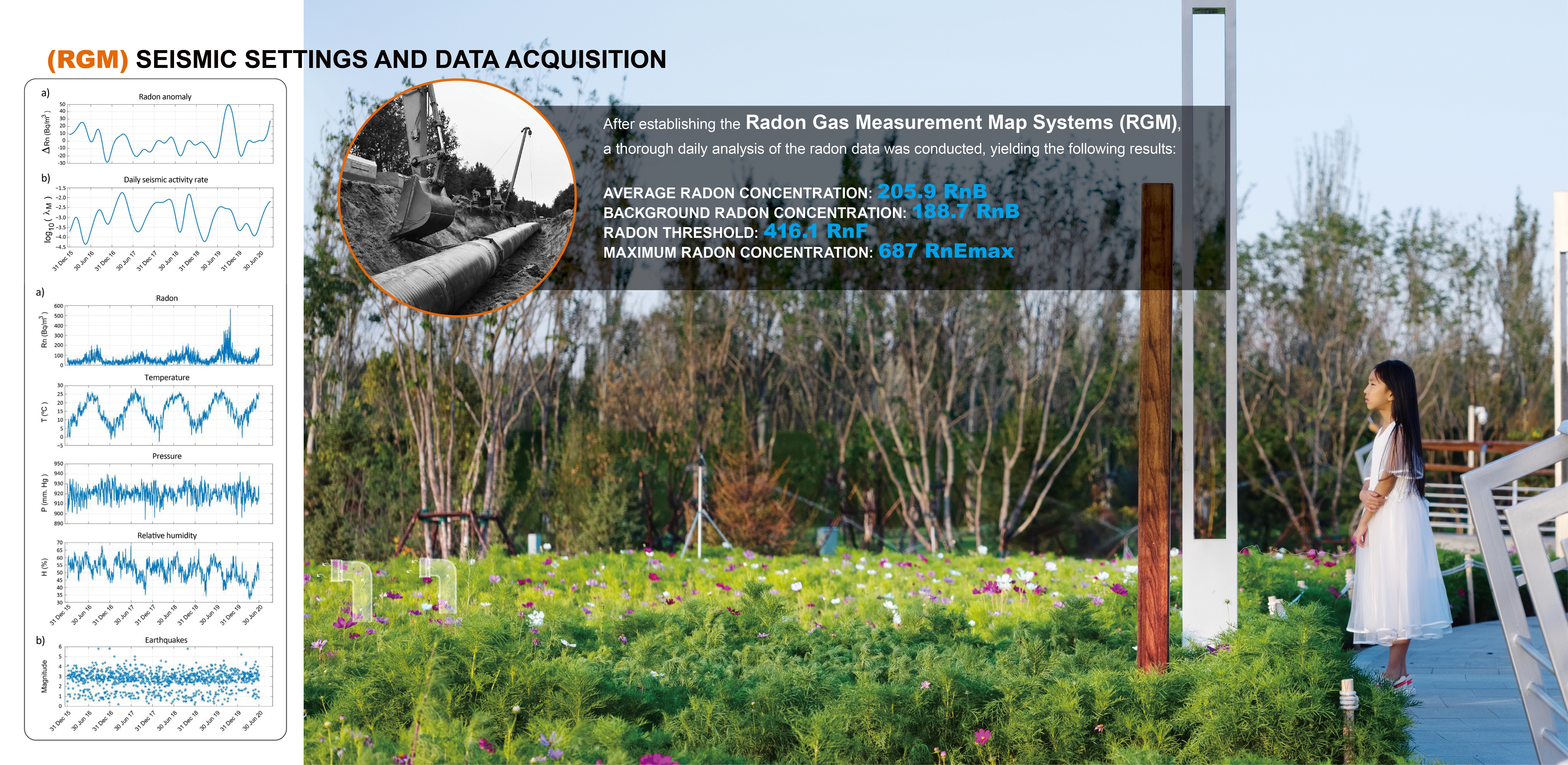
2.2 Strategy 2. Radon Gas Measurement Map Systems (RGM)
Research reveals that radon fluctuations in seismic-prone regions are key to earthquake monitoring. The radon system along Park’s mountain roads provides critical data, helping disaster management in Longquan Mountain swiftly identify high-risk areas during seismic events. A network of Radon Gas Measurement (RGM) units continuously tracks radon fluctuations. Data from 15 collectors is processed at a mountain-based monitoring center, generating color-coded risk maps for rapid
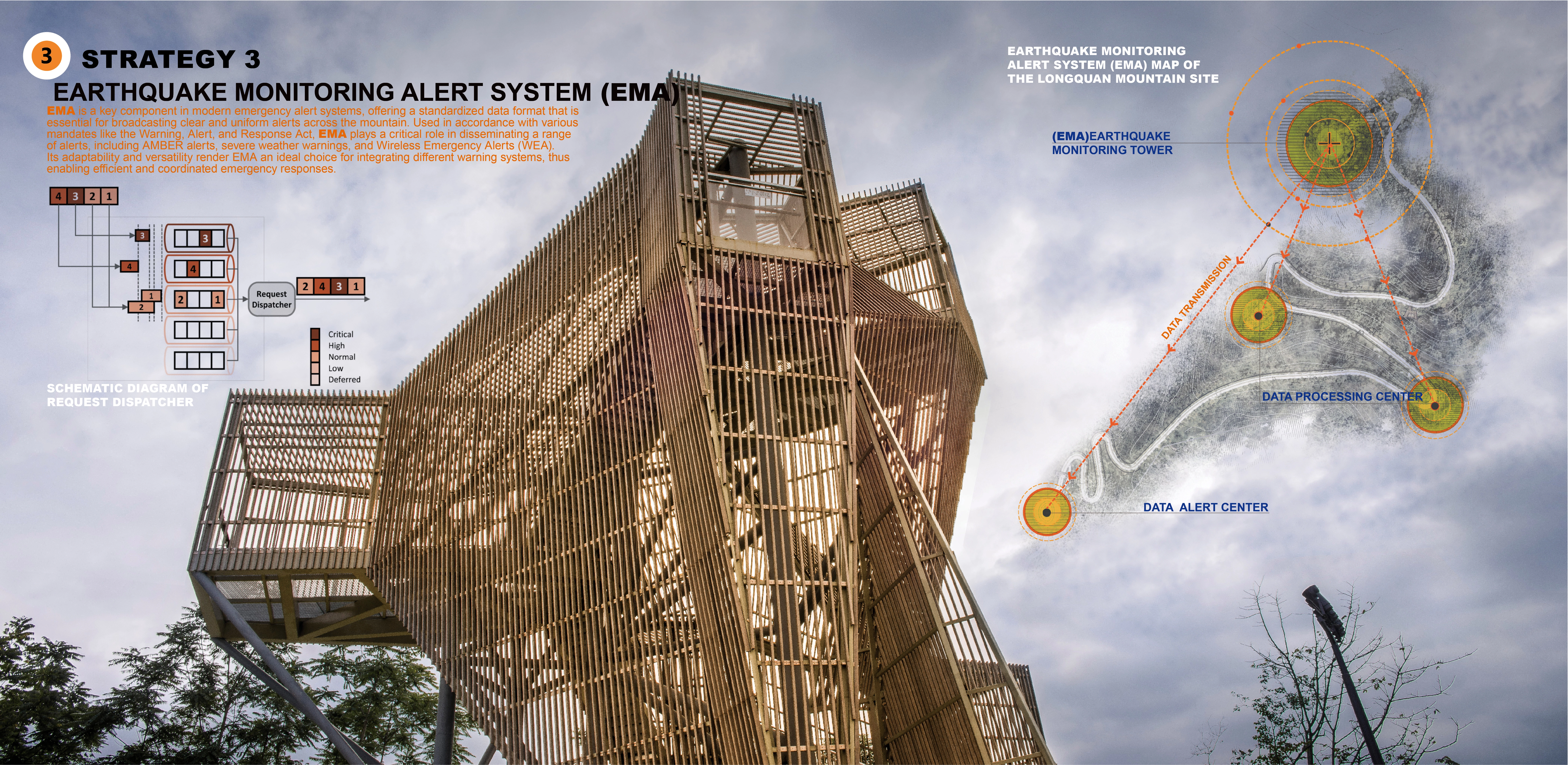
2.3 Strategy 3. Earthquake Monitoring Alert System (EMA)
The Earthquake Monitoring Alert System (EMA) provides standardized, real-time alerts across the mountain, integrating with emergency warning systems like AMBER alerts and Wireless Emergency Alerts (WEA). At its core, an earthquake-resistant Monitoring Tower houses advanced seismographs for real-time detection while doubling as a scenic observation point for geological assessments. Data Processing Centers track seismic activity and soil displacement, relaying critical insights to the Alert Center, which delivers intuitive, map-based warnings. This integrated system enhances emergency response efficiency, ensuring swift, informed decision-making for disaster preparedness.
3. CONCLUSION
This study presents a landscape-based approach to earthquake disaster mitigation by integrating Geological Restoration of the Mountain (GRM), Radon Gas Measurement Mapping(RGM), and the Earthquake Monitoring Alert System (EMA). By combining advanced hazard prevention with ecological restoration, the design enhances seismic monitoring, early warning, and disaster resilience while also promoting soil and water conservation, landslide mitigation, and landscape aesthetics. Beyond reducing economic losses, this strategy transforms Chengdu’s mountainous terrain into a multifunctional public space, fostering ecological resilience and community engagement.
-
- Chen Guo - Project Manager: Chengdu Municipal Bureau of Planning and Natural Resources
- Shihan Li - Chengdu Vanke
- Luoyin Mei - Chengdu Vanke
- SASAKI - Planner
- 94.7 Studio / Jun Zhou - PHOTOGRAPHER
-
- Tree of Heaven, Japanese Cinnamon, Citron tree, Mandarin tree, Chinese Nettle Tree, Goldenrain Tree, Japanese Maple, Crape Myrtle, Confederate Rose, Sweet Osmanthus, Dawn Redwood, Ginkgo, Camphor Tree , Blue Jacaranda, Heavenly Bamboo, Sword Fern, Marguerite Daisy, Golden Sweet Flag, Golden Coreopsis, Chinese Fountain Grass, Japanese Araliac, Variegated Japanese Aucuba, Chinese Silver Grass, Dwarf Pampas Grass, White Clover, Eulalia Grass, Indian Blanket, Garden Cosmos, Swamp Fountain Grass, Purple Loosestrife, Common Reed, Orange Daylily, Mexican Bush Sage, Yellow Bush Daisy, Hooker's Cuphea
Advertisement
Related Awards
Honor Award, Research
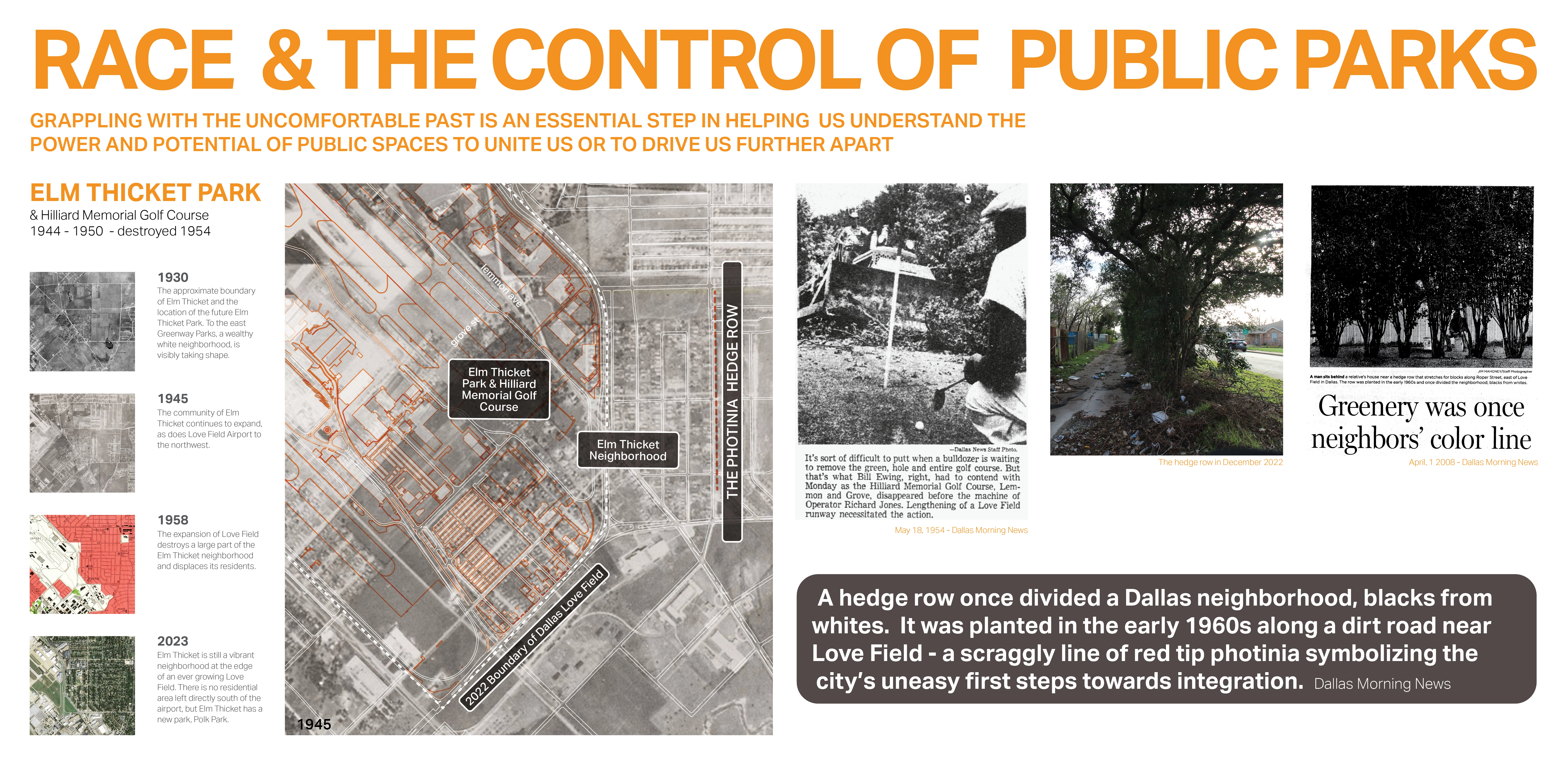
Race and the Control of Public Parks
This research uses a century long historical analysis of the public park system in Dallas, Texas, USA to uncover the physical and psychological ways in which public landscapes and the works of landscape architects have segregated urban spaces and how we might fight against these design practices. Through reframing past practice this work seeks to create a method for informing design thought and practices that seek to create a more just built environment.
Related Articles
Landscape Architecture Magazine
LAM Wins Five ASBPE Awards
Landscape Architecture Magazine earned national and regional honors for editorial excellence, publication design, and profile.
Jun 1 2026