.webp?language=en-US)


The Fluvial Lexicon
Matthew Seibert, Student ASLA; Benjamin Wellington, Student ASLA
This was extremely theoretical, yet shows amazing talent. It pushes people to engage with the river. There are a lot of big, systemic schemes; and there are small interventions. This one connects the dots.
Awards Jury
-
By appropriating a site's environmental systems a new framework for design is developed. This design method is open, responsive, and mutable to an environment's change over time. This architectural language built on ecological process is speculatively executed to imagine future potentials for a batture landscape along the Mississippi River in Baton Rouge. Suffering from the consequences of the levee's design, the site and proposed design method speak to the necessary potential of marrying human use and ecological process.
-
In Baton Rouge, the transition from urban infrastructure to the Mississippi River is largely defined by the levee, a linear wall executing a brute physical division between river and city. The river's dynamic system of forces and players has largely been excluded from the design of constructed spaces. This attitude and framework of approach toward the river can be seen as symptomatic of broader 20th century attitudes toward river systems. With the environmental consequences of confining the Mississippi River visible across Southern Louisiana, the need for new approaches toward river-edge design is not only apparent, but urgent.
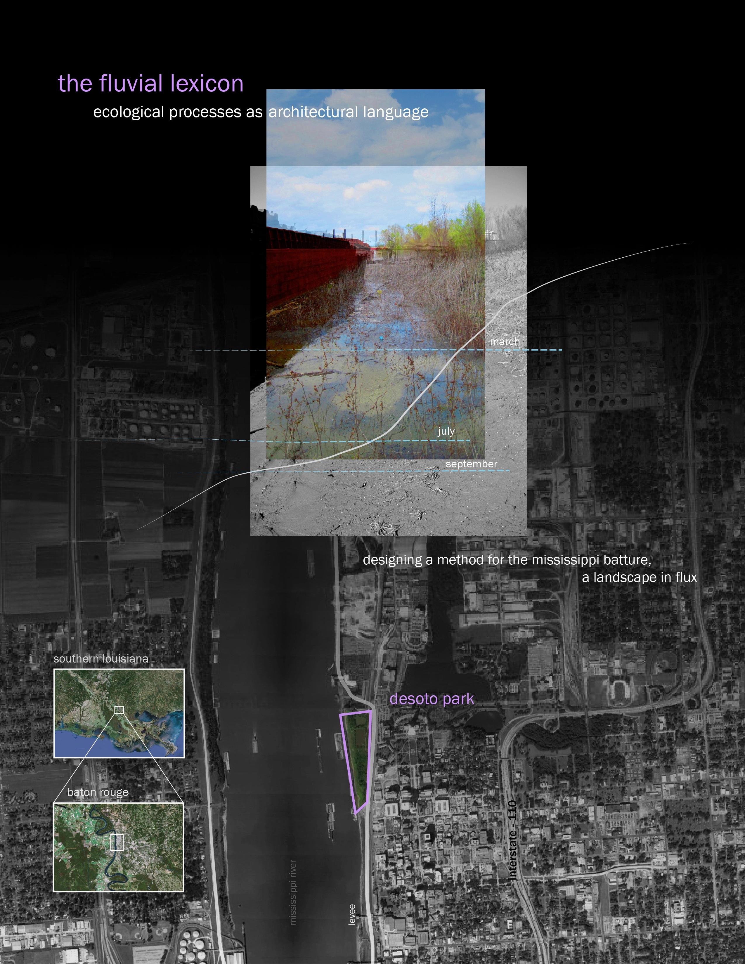
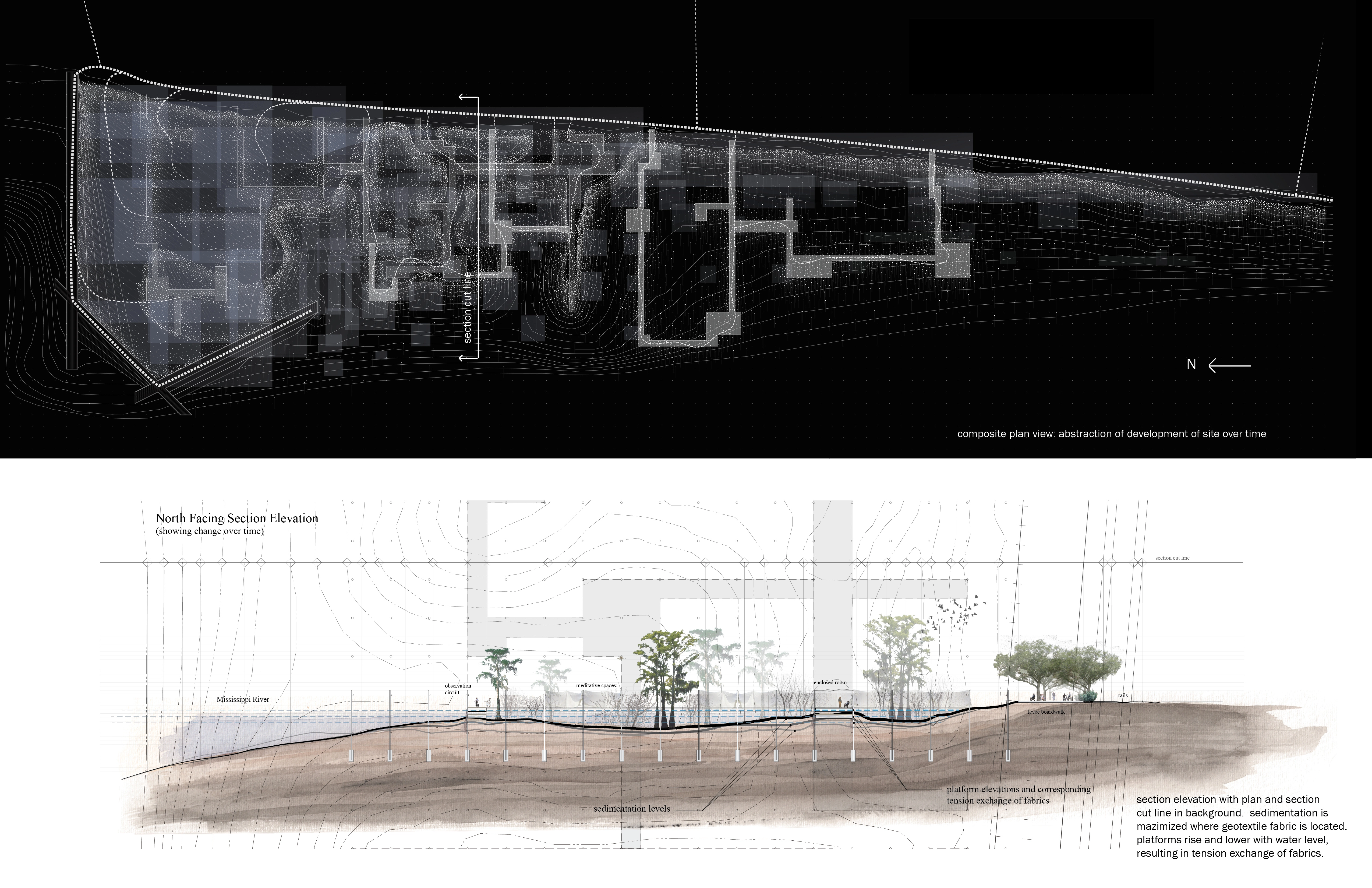
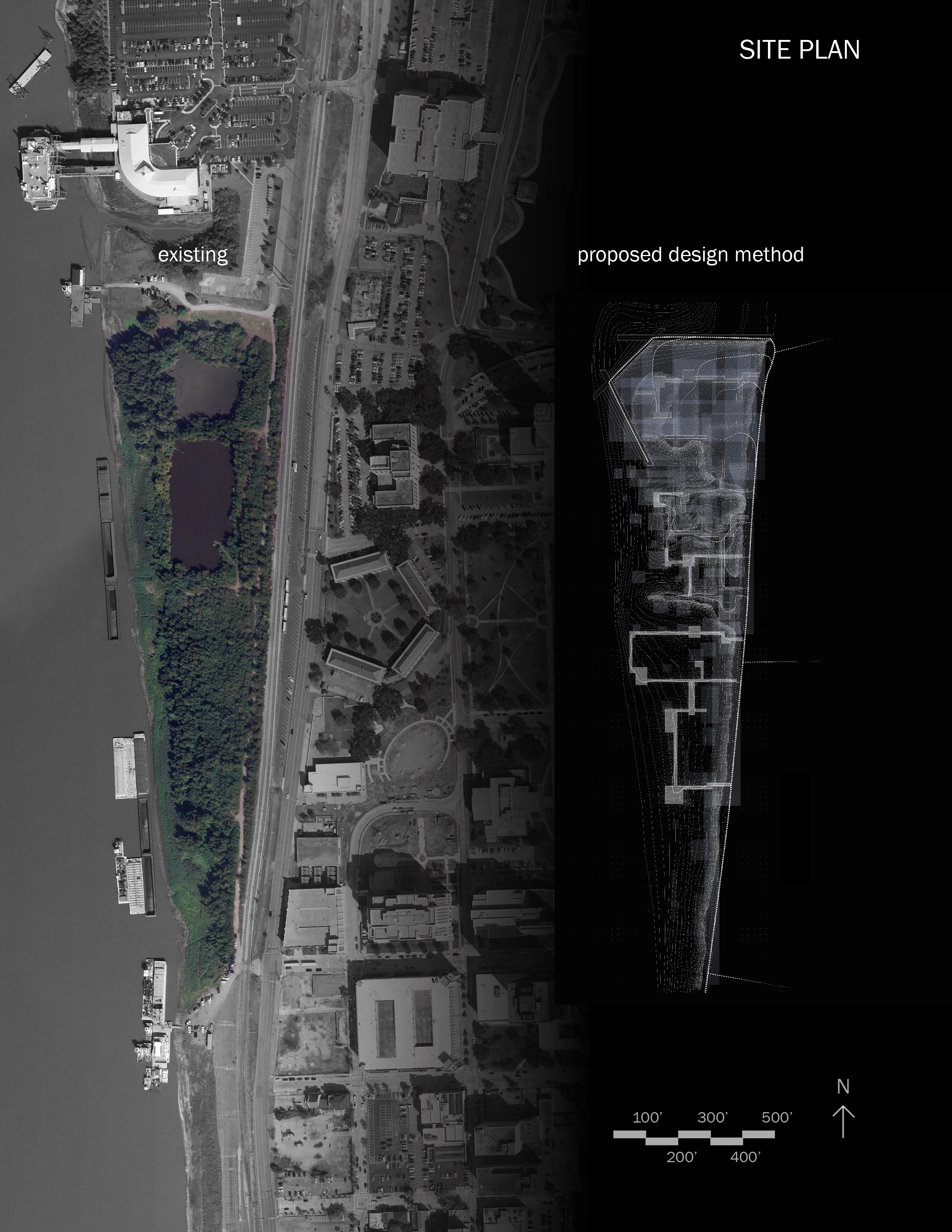
In order to investigate new methods for designing with river systems, we focused on small-scale design, looking at Desoto Park, a parcel of under-used land next to the Louisiana State Capitol grounds in Baton Rouge. Located north of the concrete downtown levee, the site is currently covered in successional vegetation, and is subject to yearly flooding by the Mississippi. This project researches a method for designing human spaces in Desoto Park in a way that compliments and harnesses, instead of confining, Mississippi River systems.
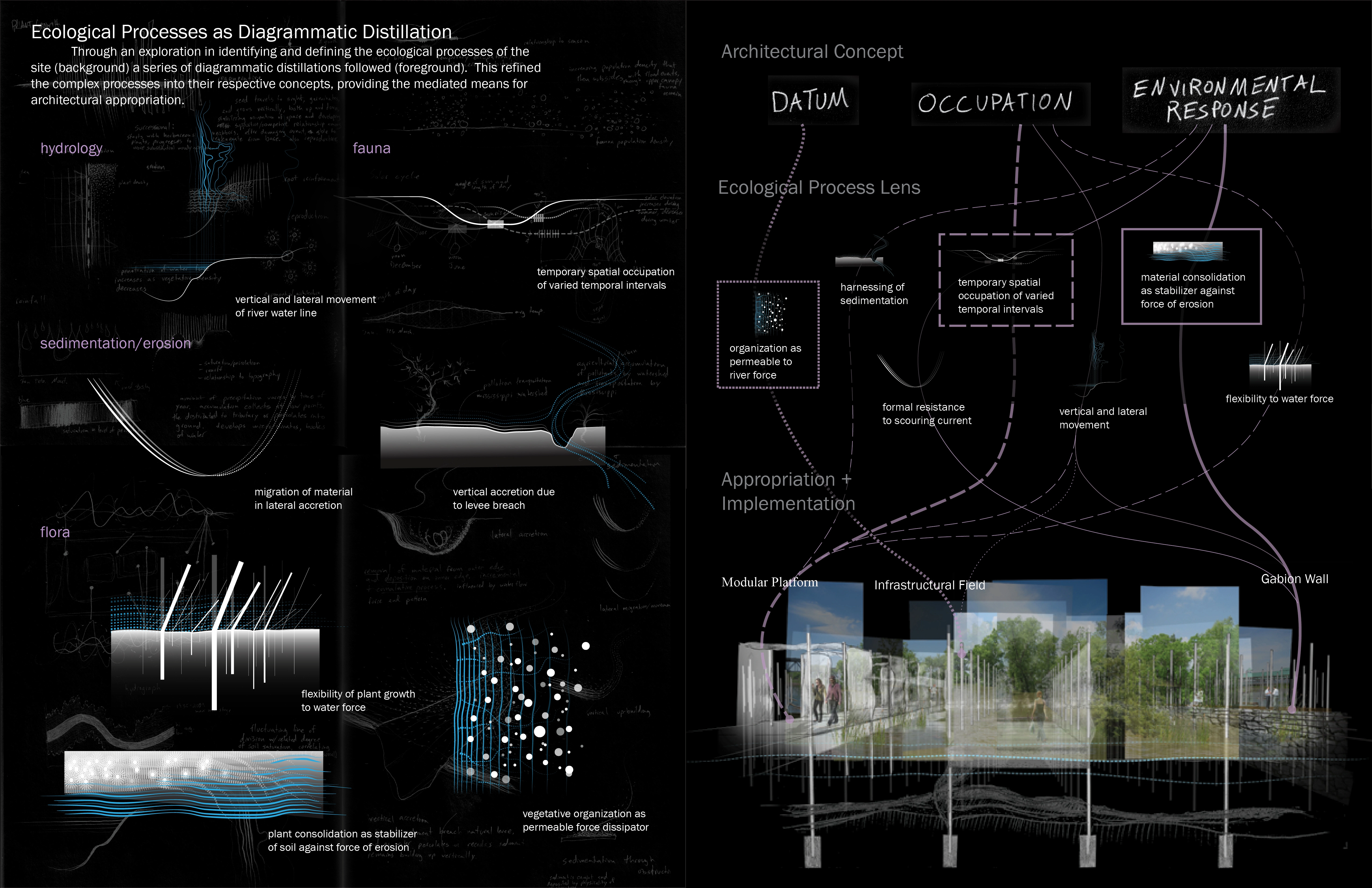
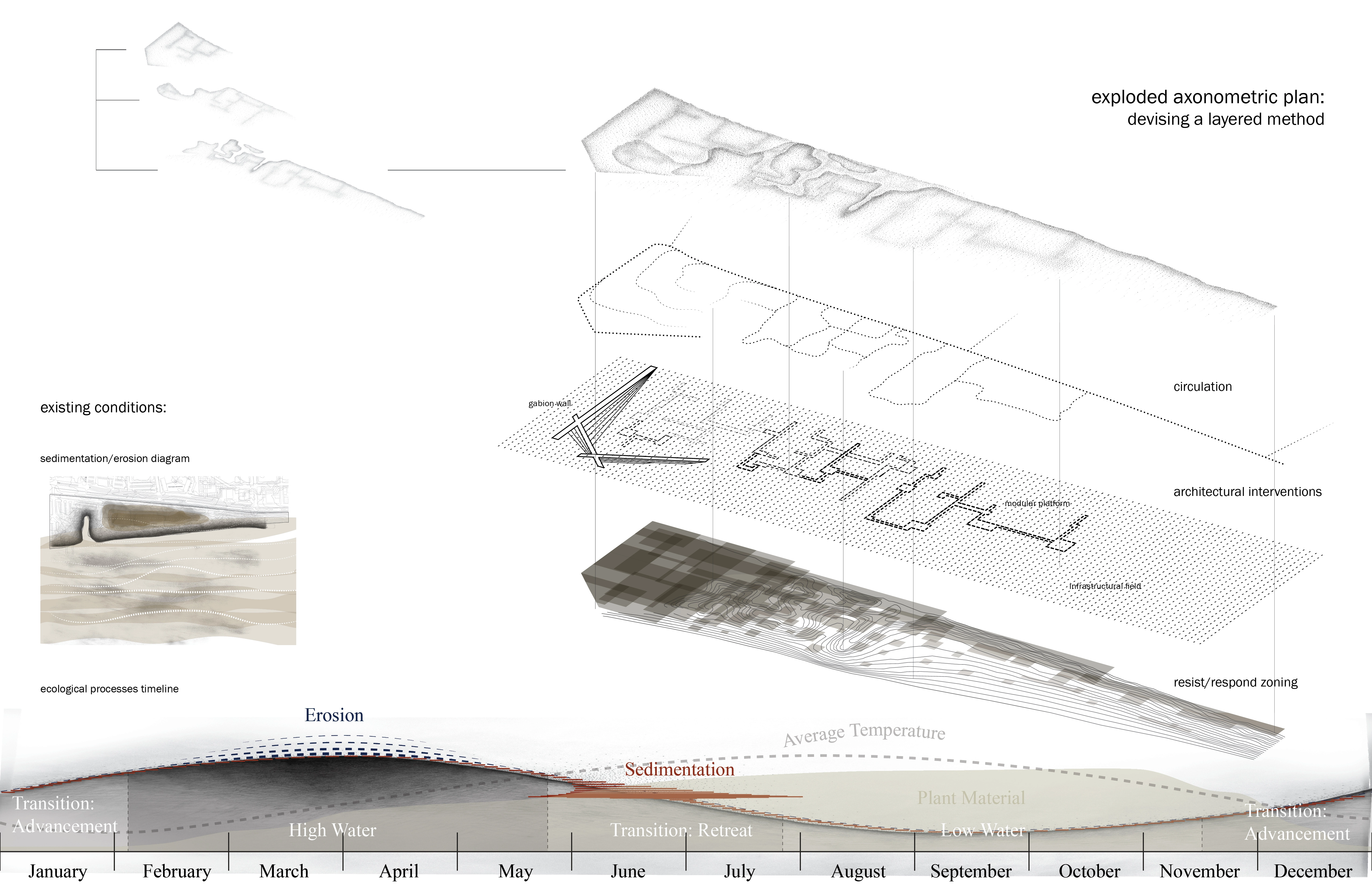
Desoto Park is defined as a layering of cyclical ecological processes — sedimentation/erosion, plant growth, river level fluctuation, animal migratory patterns, among many others. The complex interaction of these systems results in a site that is in a constant state of flux, with land building and subsiding, sediment accreting and washing away, a plurality of ebbs and flows. In order to design for a system of this complexity, these ecological systems have been diagrammatically abstracted into an architectural language. Sedimentation and erosion are defined by the vertical and lateral buildup and dispersal of sediment. Plants function as soil stabilizers against erosion, permeable river force dissipators, and sediment accretion traps. River levels fluctuates both laterally and vertically. This abstraction of ecological systems allow for the design of architectural tools, or interventions, based on these abstractions. These architectural tools influence, respond to and maximize ecological processes, slowly reshaping the site in a controlled, though not scientific, process.
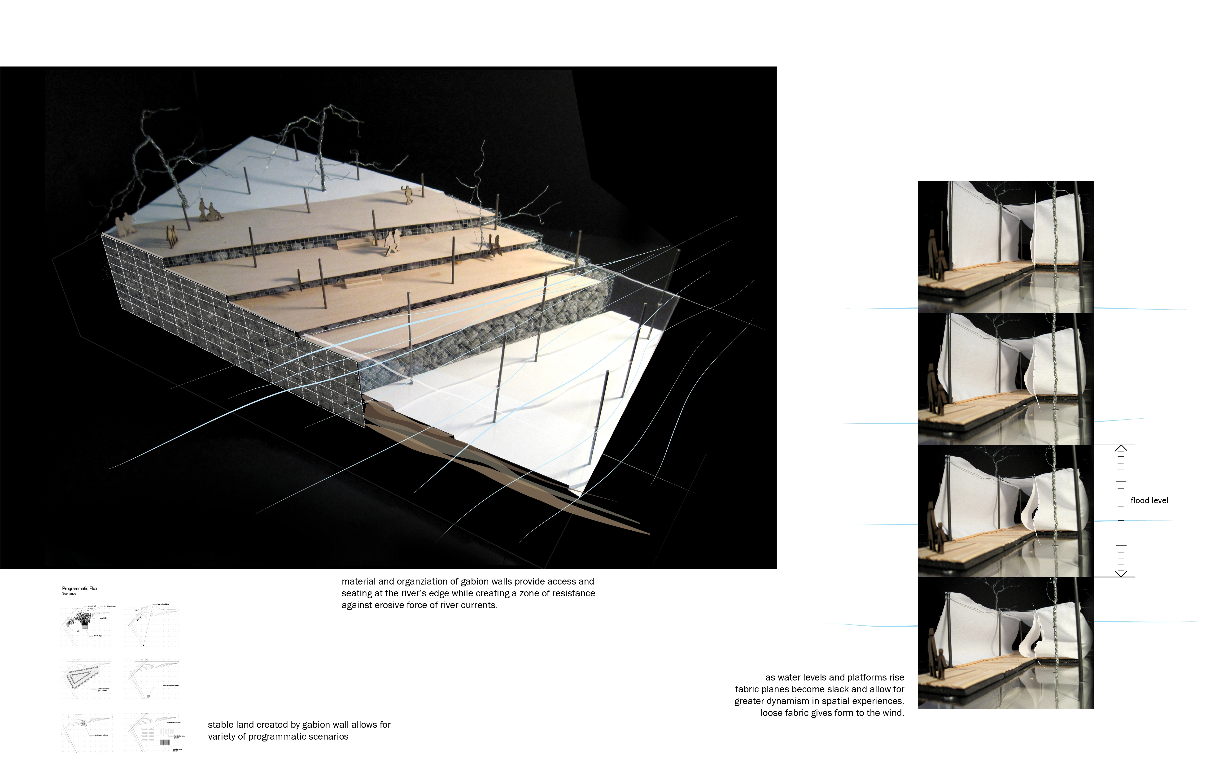
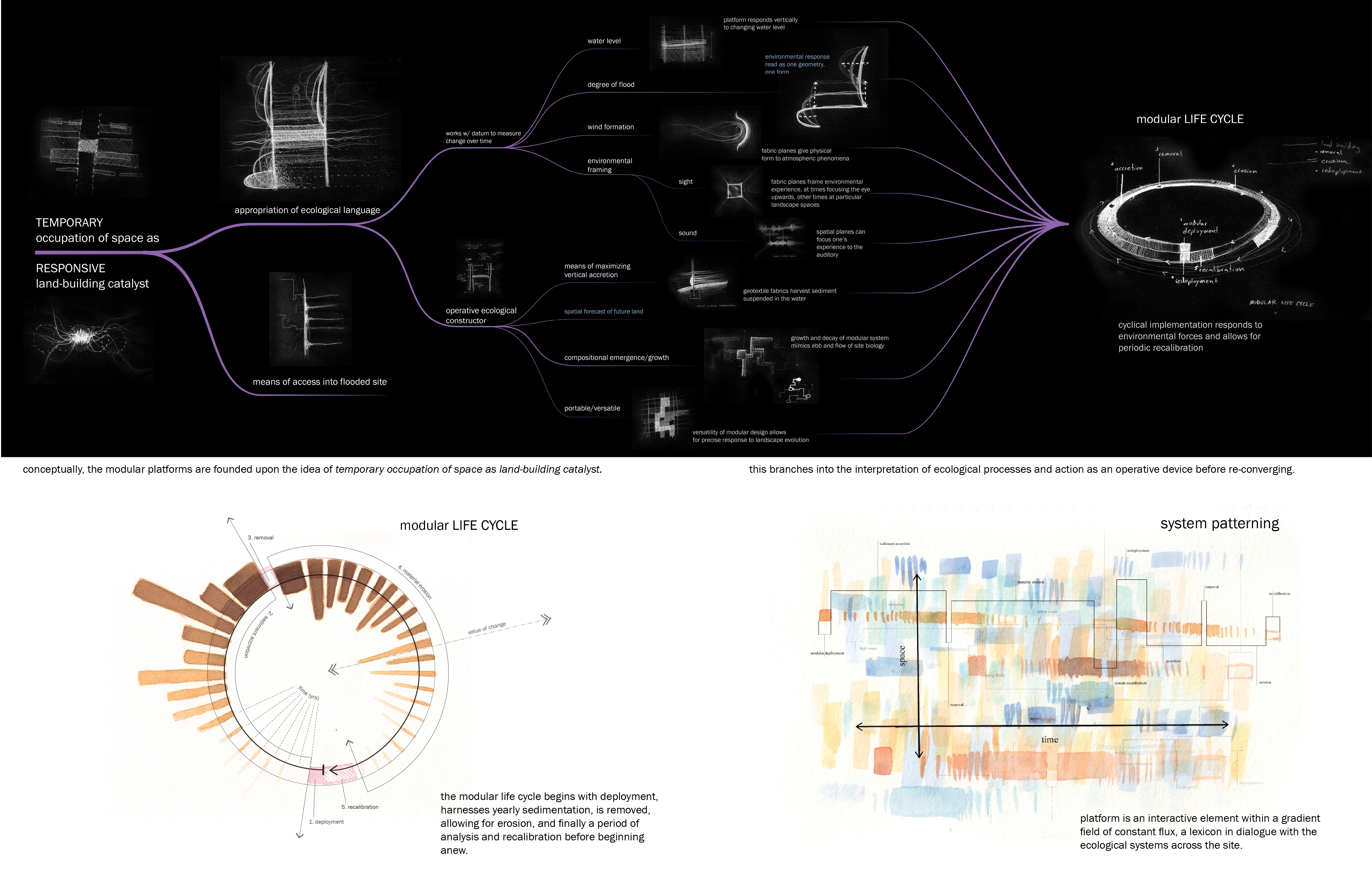
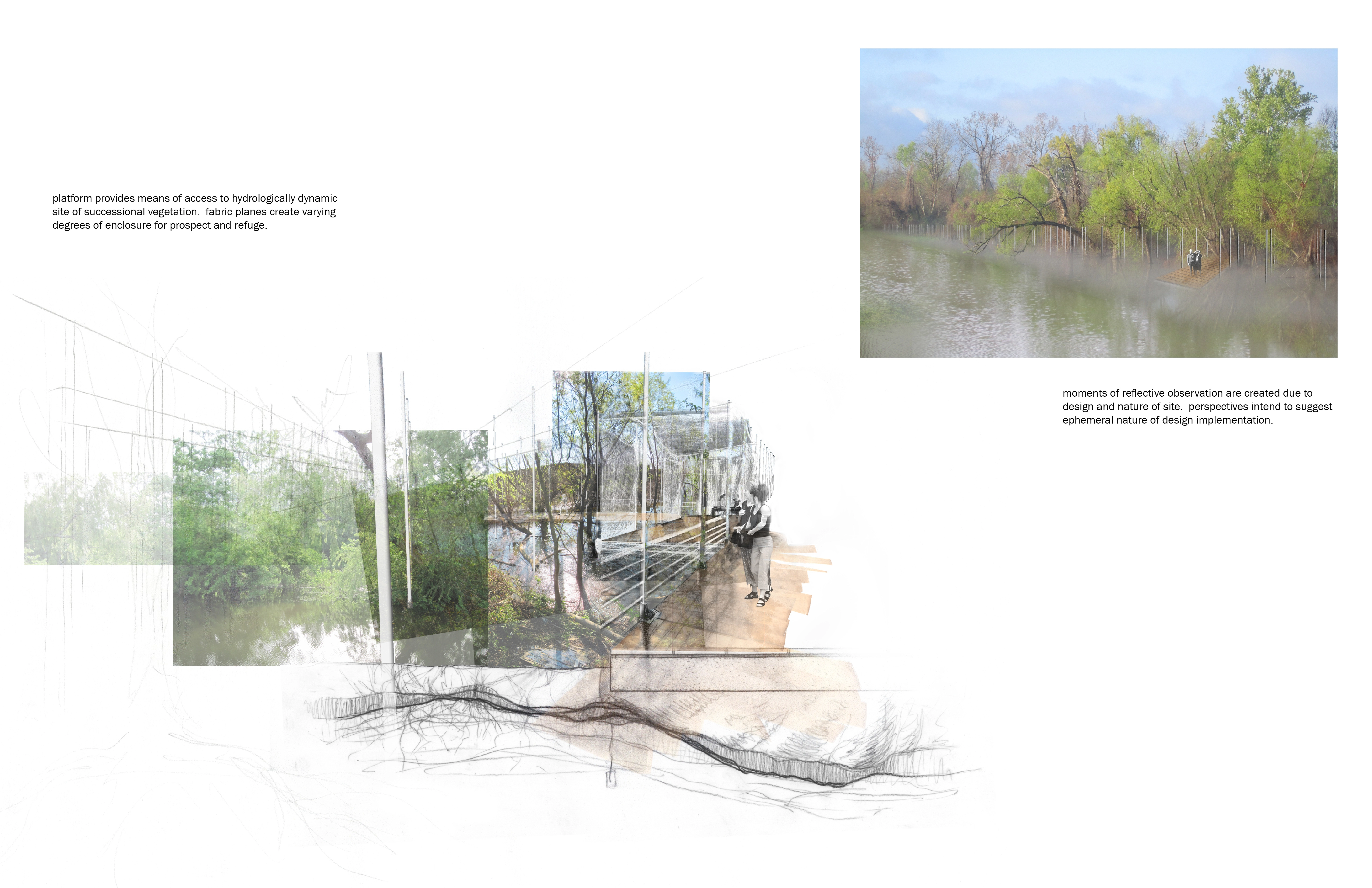
This project proposes three architectural tools: modular floating platforms, gabion walls, and an infrastructural field. The infrastructural field consists of metal poles, spaced 20' apart, laid across the site. Extending linearly from below to above ground, the poles mirror the formal qualities of the site vegetation. Allowing river currents to flow through, the infrastructural field also mirrors vegetation's organization as permeable to current force. Moreover, the field acts as datum with the modular platforms performing as variable in a didactic design informing observers to the landscape's change over time. The modular floating platforms attach to these poles in an ever-changing arrangement, and are conceptually founded upon migratory fauna's temporary occupation of the site's spaces. In addition to influences by various other site processes this is appropriated into the architectural idea of temporary occupation of space as a responsive land-building catalyst. These platforms provide access to the site, interpret environmental processes, and act as an ecological operative device. Taking the function of vegetation capturing sediment suspended in the water, the platforms utilize underwater geotextile fabric to catch sediment, maximizing the processes of sediment accretion and land building. They act in a cycle of deployment, sediment accretion, and removal, leaving behind newly created land that then falls sway to the erosive forces of the Mississippi. A period of recalibration is performed, followed by redeployment of the modular components. In this way, the platforms indicate the future topography of the site, and the topography of the site indicates past arrangements of platforms. Unlike the cyclical transient platforms, the gabion walls are intended to be relatively permanent installations on the site. In the way vegetation disperses river forces and stabilizes land, the gabions are a tool of resistance against river currents, creating a zone of minimized erosion, and therefore maximized stability.
The initial arrangement of the site involves the deployment of the gabion walls in the northern end of the park. The existing levee trail south of Desoto Park is extended along the city-side edge of the site, providing access. The floating platforms are deployed within the space protected by the gabion walls in the northern end of the site. Over time, as sediment accretes and land builds within the gabion walls, the platforms will migrate southward, away from the gabion walls and increasingly subject to river currents and erosion. In this way, a gradation of temporality is created across the site, with the gabion-protected northern end building stable land, gradually transitioning southward into a fluctuating arrangement of eroding land and sediment-accreting.
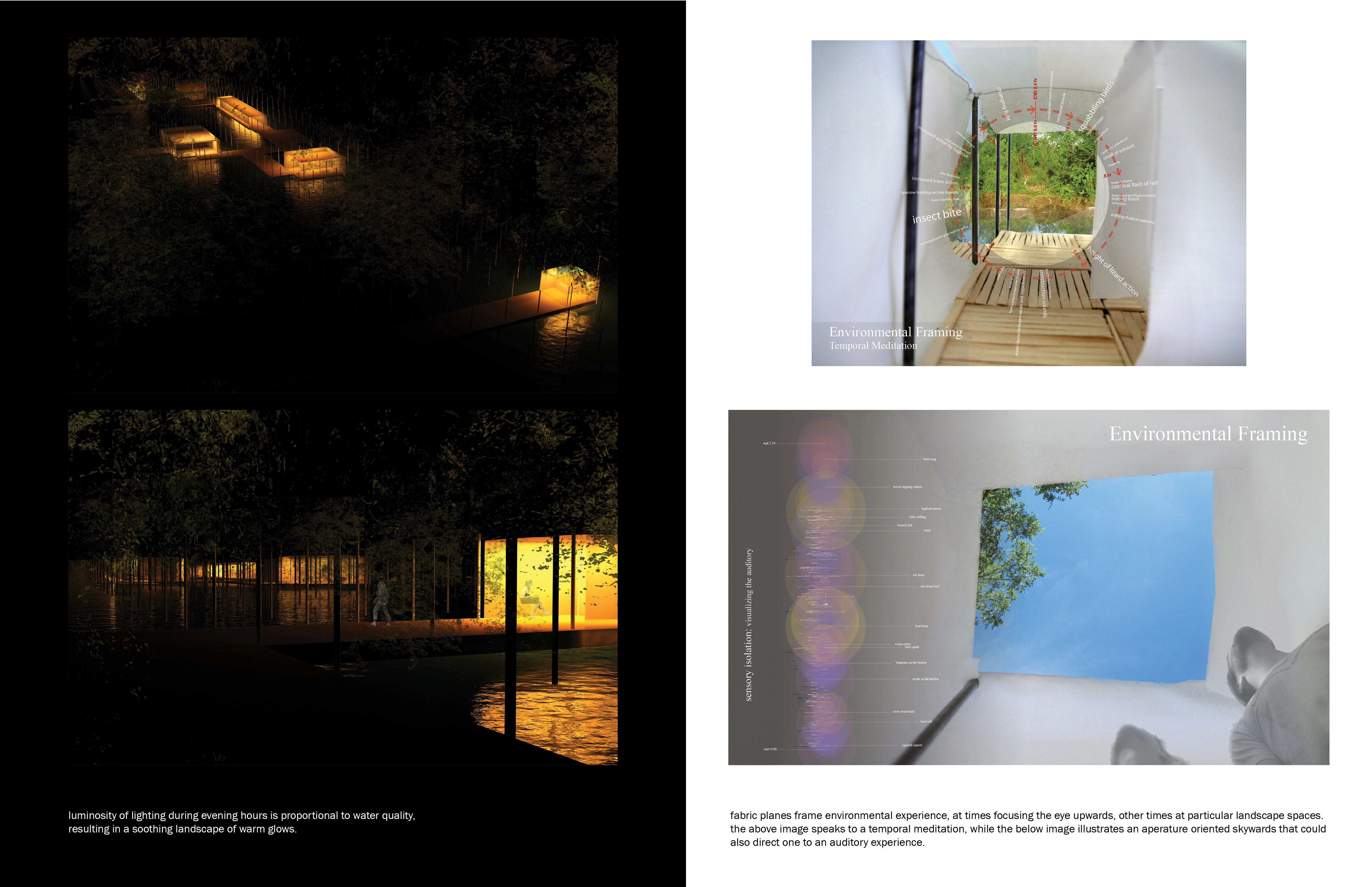
The creation of a gradation across the site of stability to fluctuation, of resistance to response, enables a wide range of possibilities for human use. Land stabilized by the gabion walls can be used for programmatic scenarios such as athletic fields, outdoor markets, and high-occupancy gathering spaces. The dynamic southern end of the site additionally holds many possibilities. Fabric attached to the infrastructural poles and floating platforms creates human spaces with varying degrees of enclosure. As the river level fluctuates, so will the tension of the fabric, allowing the experience of these spaces to shift with the changing river. The material of the fabric, giving form to the wind and changing hue in the rain, will decay over time in a choreographed manner, further influencing the spatial experience created. In this way, like the platforms themselves, the fabric is used to create spaces that change cyclically, operating on a timeframe dictated by environmental conditions. By changing with ecological systems, the architectural elements deployed on the site can be seen as ecological indicators. Tension of fabric, and the experience of the spaces they create, makes the level of the river legible and experiential. The position of the platforms indicates location of sediment accretion and future land. Additionally, the fabric planes perform as environmental frames, methodically focusing an individual's experience of the site with a calculated design intention. At times directing one's sight, at times isolating one's sensory perceptions the fabric “rooms” result in meditative spaces experienced on a personal level. By functioning not only as tools of ecological performance, but also as ecological indicators, the architectural interventions deployed on the site can make ecological systems legible through changing human spatial experience.
By creating an infrastructure for the flexible deployment of these architectural interventions, a certain level of improvisation is made possible in the gradual formation of the site. Elements can be deployed and removed, with periodic analysis and recalibration. In this way, inherently complex ecological systems are appropriated, with the site growing organically within a window of potentialities.
This project can be viewed as the designing of a method, layering infrastructural systems both in complement to and within existing ecological systems. While this project specifically addresses the processes of the Mississippi River, and the prevailing division of urban infrastructure and river ecology, the strategy of creating an infrastructure upon which architectural elements can be introduced to influence ecological systems is broadly applicable. The intention is to marry human use and ecological process.
-
Matthew Seibert would like to thank his parents for their continuous support and interstate chauffeuring.
We would also like to thank LSU's Coastal Sustainability Studio.
Advertisement
Related Awards
Award of Excellence, General Design
A Floating Forest: Fish Tail Park in Nanchang City
In Nanchang, within the Yangtze River floodplain, we revitalized a heavily degraded 126-acre landscape into a floating forest that manages stormwater, restores habitats, and provides diverse recreational spaces—all within a limited budget and a short timeline. This innovative urban nature model strengthens the district’s identity and spurs surrounding development. Fish Tail Park offers a scalable solution for flood-prone regions, seamlessly integrating flood resilience, ecological restoration