.webp?language=en-US)


-
This project transforms mono-functional infrastructure into multi-functional systems, addressing storm water issues and creating an identity for the largely uninhabited corridor that bisects Baltimore. The unique space proposed is comprised of a series of wetland parks, formed through revealing and adapting the layered history of the Jones Falls River and expressway. The once buried and problematic infrastructure is re-interpreted as regenerative space that supports ecological and cultural functions, engaging both sides of the city.
-
Historical Context
The Jones Falls River was a primary resource for the city of Baltimore. As the city encroached on the territory of the river, filling in wetlands and destroying the estuary, floods threatened the downtown business district. After significant floods took many lives and destroyed valuable property, the river was channelized and eventually buried in a culvert. Presently The Jones Falls Expressway runs over and parallel to the underground river forming a physical and psychological barrier between east and west Baltimore. The city is considering various scenarios for removing all or part of the elevated expressway south of Penn Station. The decommissioning of the JFX opens up new possibilities for this underutilized corridor.
Ecological Issues
The Baltimore harbor suffers from very poor water quality; this is an ecological, cultural, and economic concern. The lower Jones falls watershed encompasses 58 square miles, composed primarily of highly impervious urban land. Currently the pollutants and trash that enter the stormwater in this region converge within the culvert and are released into the heart of Baltimore’s primary tourist attraction, the inner harbor. At a regional scale the ecology of the larger Chesapeake Bay is threatened by contaminates from the matrix of tributaries, such as Jones Falls that feed its waters. In this project the urban fabric of Baltimore is considered as part of this larger Estuary system.
Project Objectives
Reveal layers of existing infrastructure. Daylight the culvert under Fallsway Road, and divert the Jones falls river base flow. Expose the geomorphology of the corridor by uncovering the bedrock layer at grade with the base of the culvert.
Transform mono-functional systems to serve multiple purposes. The culvert that once confined the last mile of Jones Falls River now filters and stores stormwater, provides room for flashy water, irrigates the river, and becomes a boardwalk. The robust expressway structure supports multiple modes of transportation and shelters public events.
Generate public space where diverse flows intersect and overlap. The flood line can be understood as a generative edge, delineating a site for desirable and adaptable public space.
Urban Alchemy
Baltimore’s culvert and topographical change are utilized to create manifold systems of filtration and infiltration. A network of landscape features such as check dams, constructed wetlands, and bio swales work in concert to detain, clean, and manage water. Street edge bioswales are introduced to filter storm water run-off before it reaches the culvert, effectively reducing the volume of water and concentration of pollutants that enter the Chesapeake Bay. Adaptive infrastructure functions as decentralized systems composed of small moments of filtration and infiltration. The three 20’x16’ concrete chambers of the culvert are retrofitted to clean, store, and distribute water. The first chamber contains baffle boxes to trap trash, while sand filters remove debris and pollutants cleaning storm water before it moves into the second chamber to be stored. Upon reaching capacity the water spills from the second chamber into a third. The final chamber opens towards the river allowing the filtered water to irrigate the stream. These new functions make the culvert a dynamic feature in the urban landscape. During storm events water will occasionally shoot up out of slots cut into the top of the concrete channel, and urban waterfalls will form along its edges. The culvert boardwalk becomes a destination for viewing multifarious hydraulic processes.
River water and brackish harbor water meet within the culvert. Flooding forces come from run-off during storms and also move up from the harbor. Our site acts as an estuary providing wetland habitat that improves the water quality, while increasing water storage capacity in flood events. The design also shapes public space, creating a stream environment with ecological and esthetic value in both high and low water conditions. The wetland extends into the adjacent land that is now a parking lot but is slotted for new development. Bio-filtration swales and micro-topography structure the ground so that new buildings can be sited within the floodplain.
An island between the east and west sides of the river is sited under a portion of the expressway structure that is currently the location of the Baltimore farmers market. We are preserving this piece of the northbound structure to provide cover for the farmers market as well as other public events and performances. A much larger portion of the southbound structure is kept in place for an elevated pedestrian and cyclist trail. Tributary streets lined with bioswales reach east and west extending the new trail into the urban fabric. The corridor is transformed from a mono-functional conduit for automotive traffic into a multifunctional pathway that provides opportunities for pedestrians, cyclists, vehicular traffic, and watercourses to weave together in a diverse system of overlapping and intersecting flows.
-
Robin Dripps
Baltimore City Planning Department — Advised us regarding Baltimore’s cultural and political climate.
Biohabitats — Shared their knowledge of urban stream restoration issues, and regenerative design approaches.
RK&K — Presented their feasibility analysis of decommissioning the Jones Falls Expressway
Advertisement
Related Awards
Honor Award, Student Collaboration
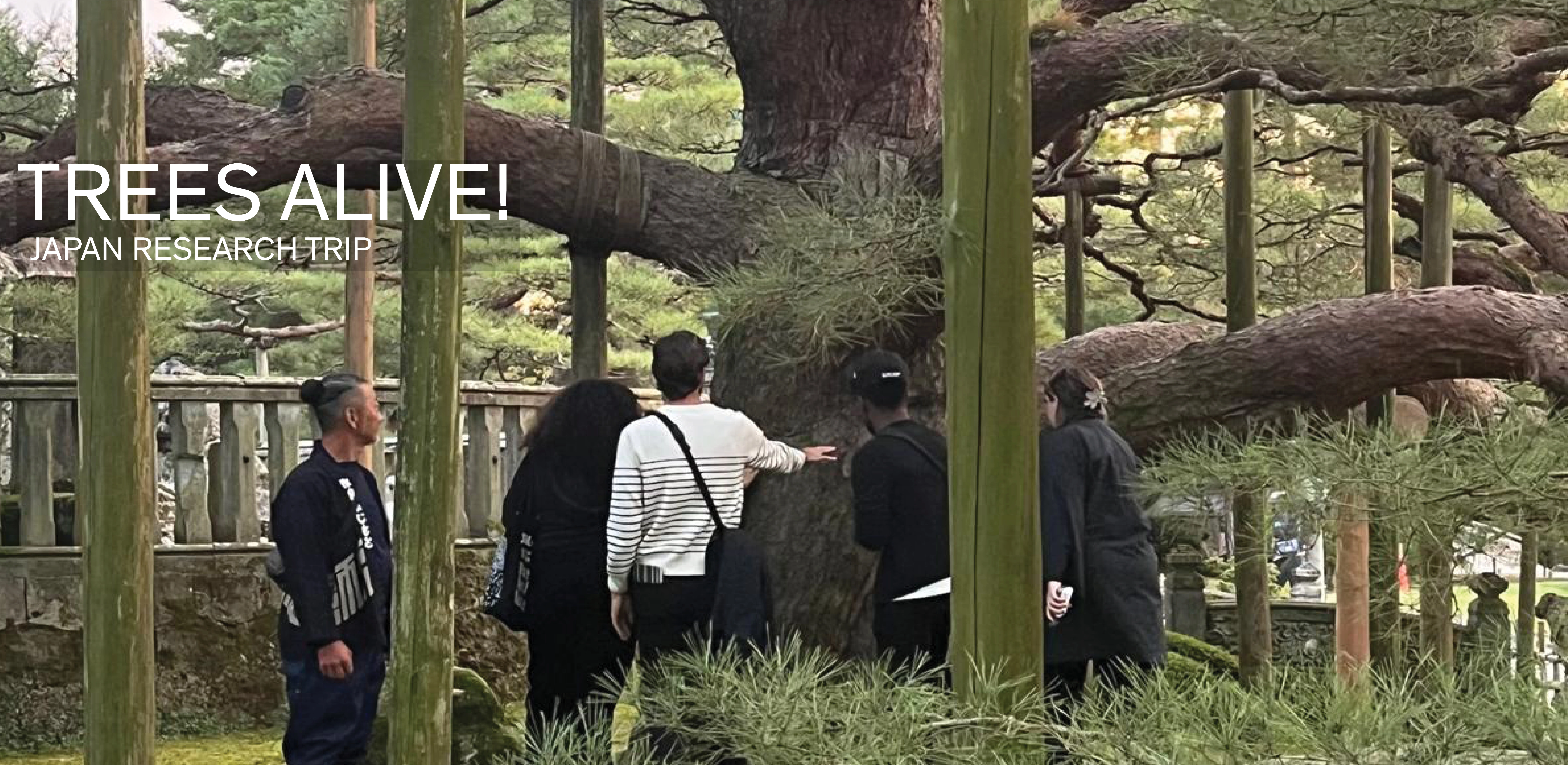
TREES ALIVE!: Techniques, Details, Traditions
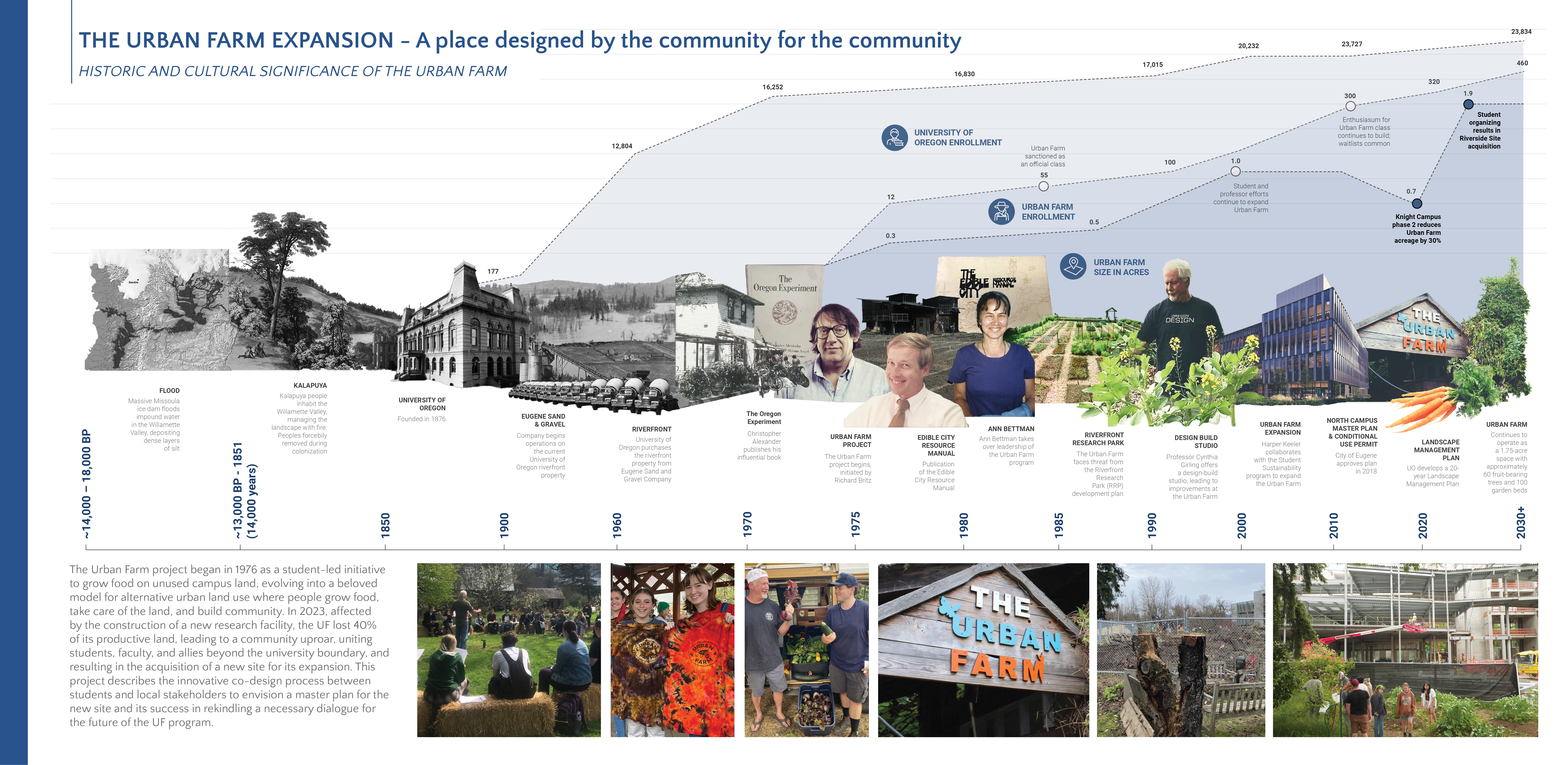
TREES ALIVE! is a collaborative research and travel exchange between American and Japanese landscape architecture programs to study the techniques, details, and cultural traditions for trees in contemporary urban landscapes. Students participated in collaborative technical workshops and visits to significant gardens and landscapes to investigate urban tree planting and legacy tree conservation in Tokyo, Kanazawa, Chicago, Columbus (Indiana), Philadelphia, and New York. Two technical