
.webp?language=en-US)


Greg Smallenberg, FASLA
on Landscape Architecture in Canada

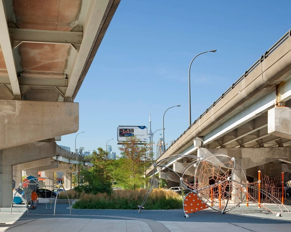
In Toronto, your firm, Phillips Farevaag Smallenberg, just announced the opening of Canada's first underpass park, a public space that transforms one of the city's least desirable spots into an asset. The first pieces of the park offer a playground for kids as well as basketball hoops and skateboard ramps for teenagers. Why put a park under a highway? Why design this park for exercise?
Western societies are littered with spaces that can only be considered incidental, leftover pieces of the urban fabric. They're generally a result of urban infrastructure -- and usually some form of transportation infrastructure -- that ran amok in the '40s,'50s, '60s, and '70s. Cities have been faced with all sorts of these leftover spaces ever since.
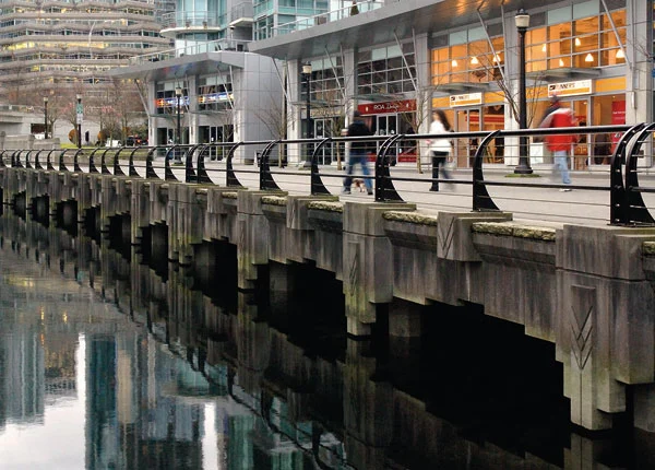
Underpass Park is found in a redeveloped community that Waterfront Toronto is putting forward called the West Don Lands. The space needed to be easily traversed, safely and securely. We thought, why not actually make it interesting fun and give it some community use?
Together with Waterfront Toronto, the idea was born that the space would become a park, in large part just to take advantage of the free weather protection. In Toronto, there are not a lot of places where you can play basketball or go skateboarding 12 months of the year without getting soaking wet or covered with snow. So the project was about turning something that most people looked at as a constraint into an opportunity.
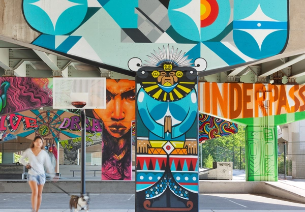
There's a couple of openings in the overhead structure that have allowed us to create a softer kind of landscape with trees that humanize this space, but for the most part, it's a space that doesn't get a lot of light or any rain, so the solution was a hard surface one where we put in largely recreational opportunities that could best take advantage of the space. At the same time, we created enough flexible space, so there could be a farmer's market, informal performance theater, and the like.
There is another part that is much greener. It's almost out from underneath the overpasses—so, lots of trees, community gardens, etc. When the park is read as a whole, it's going to feel like there's a good balance between recreational and passive park space, hard surface and soft surface.
We have been working with the Planning Partnership from Toronto in the design of the entire West Don Lands public realm. In addition, Michael Van Valkenburgh's firm has been central to the open space of the West Don Lands, designing the Don River Park, and a smaller space called River Square. All of the public realm pieces, under the direction of Waterfront Toronto, are flowing well together to create a bigger whole. Underpass Park is just one component of a much larger basket of public amenities unfolding throughout the whole community.
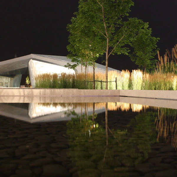
Your firm has played a major role in the rebirth of the Toronto waterfront. With the latest contribution being Sherbourne Common, a fascinating hybrid: a park that is both a water treatment plant and public space. Visiting the park, I noticed how the infrastructure can't be separated from the park. How was the park designed to be both infrastructure and public space? How well does it function as a neighborhood water treatment facility?
Early on, we were involved in the precinct planning of East Bayfront, the area in which Sherbourne Common sits. We worked with Koetter Kim, an architectural firm out of Boston. They were responsible for the built form. We were responsible for the public realm. We put together a plan that essentially took this brownfield site along a fairly disused portion of the Toronto waterfront and created a plan for a new neighborhood, which was, again, part and parcel of the whole Waterfront Toronto vision.
In this work, we were able to order the community both by circulation and open space. The open spaces took on different roles. For example, Claude Cormier's park called Sugar Beach, which just won an ASLA award this year, is part of that. West 8 / DTAH has done a waterfront promenade and they're building a significant streetscape along Queen’s Quay that will run right through the central waterfont and the East Bayfront community.
Sherbourne Common was intended to be the heart of this new waterfront community. It needed to be many things to many people. Interestingly, because the park is an example of building public realm in advance of private development, when it was completed it appeared somewhat alien because there was nothing around it. It's still a bit desolate in the area but very quickly evolving. A commercial office building promoting film and media was recently completed and directly adjacent to the park a new 3,000 student university college has just opened its doors. Hines Development out of the States is in the process of developing a significant residential and mixed use component, which is directly east of the park, so, eventually, the park is going to be bracketed by all of this really interesting and meaningful community development. It's going to be surrounded by commercial, educational, residential, and retail, which was always the plan from the beginning. This multi-use type of new community development is going to be different than anything we’ve seen in Toronto.
Sherbourne Common was intended to be the big green heart of the community. In terms of design, it's centered around the idea of sustainability. It's actually one of the first LEED-rated parks in Canada. We decided early on that we wanted to do something about stormwater. In the East Bayfront planning process the idea was that we would collect all of the stormwater within the community, and, ultimately, figure out what we were going to do with it. We weren't going to just deposit it into the city storm sewers. That wasn't on. This was a new twenty-first century community.
When West 8 came into the planning for the central waterfront in about 2006, they had developed this idea for the water’s edge, which includes what they have built now -- this hard surface promenade and, in the future, a floating or slightly-stepped boardwalk going the full length of the East Bayfront community. Underneath the boardwalk is planned a series of connected box culverts that will accept all of the storm water from the whole of East Bayfront. So, generally speaking, all of this water will move by gravity from the developing area into these containment culverts along the water's edge where sediment will filter out and eventually the water will come back into the park.
From there it travels through one of the most sophisticated UV treatment systems in the Canada if not the world. The water travels up and through the dramatic art sculptures by Jill Anholt, which you would have seen when you were in Toronto and then into biofiltration beds, taking out most of the remaining contaminants. The water eventually makes its way back into the lake in a very clean state.
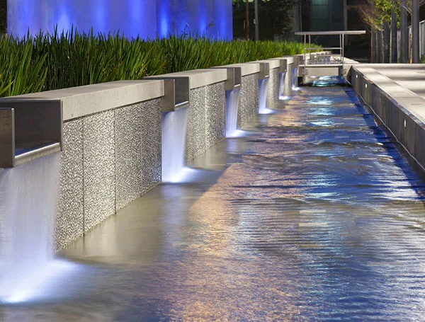
The intention is there wouldn't be a dividing line between design disciplines. First and foremost, this is landscape architecture, but it was done in a way that collaborated with artists, architects and engineers. PFS, as a firm, is always trying to do this. Landscape architecture, as a profession, is hopefully trying to do this. You do get mixed results when one discipline takes over or something else happens to skew the balance, but, in Sherbourne Common, the balance was there. The engineers, architect, and artists were very creative.
PFS set out the concept and the others plugged in all of their resources to making this thing a reality. It's almost impossible to see where the engineering starts or where the landscape architecture ends because we intentionally wanted boundaries blurred. The same holds for the art and the architecture. So from that perspective, it's a huge success for us.
Do you think, given the incredible lack of space in cities and the increasing value of that space, more urban, public spaces need to be like Sherbourne Common and double as infrastructure? Is this the model for urban parks of the future? What are the challenges to this approach?
I think it's one model for some urban areas. If you can see an opportunity where you can ride on the back of an infrastructure project or an infrastructure need, why not? In Canada, the budgets that are put forward for things like sewers and roads are exponentially greater than any budget put forward for landscape. Yet, these kinds of projects can go hand-in-hand. So why not piggyback on budgets like that? Why not make something that isn't a hindrance or a distraction in the community? If you can make it fantastic, usable, and beautiful, why not do it?
There is a real opportunity here. There's leftover urban infrastructure everywhere and there's all sorts of new urban infrastructure projects coming on line. Urban open space is scarce and you just don't find many conventional open space opportunities anymore because cities are built up. The tastier bits are all gone. We have to be really creative in how we look at opportunities.
A number of other works by your firm elegantly repurpose historical buildings and landscapes, reusing sites, but making them contemporary in the process. I was struck by the Canadian Embassy in Rome, Bellevue City Hall in Washington State, as well as Coal Harbour, the historic seawall in Vancouver. Please explain how you translate cultural landscapes-- large and small-- significant or not-- into new works.
We're very interested in cultural landscapes and there are different ways you can look at this as a the artifact or the ritual. Personally, I’m more interested in the rituals. In other words, the things that have happened in places that we're asked to take a look at as opposed to the artifact.
We're very respectful of historic properties, but we will always look for a way to put a contemporary layer on any sort of historic site or project that we're asked to come into. From our perspective, that's the way you actually make places relevant. You need to design for the next generation, which has to feel like they're a part of it. If there's no relevance, then they will eventually lose interest. And, ultimately, there will be a loss of the synergy that happens between users and these spaces.
Coal Harbour was built largely on reclaimed land. We were very interested in tracing the old shoreline. We did it in a way that recalled some of the area’s natural processes, the scouring of the sandstone cliffs by the ocean and the granite lenses that were revealed in this process. We designed a wall in Harbour Green Park that in subtle ways picks up on this.
With respect to the Canadian Embassy in Rome, it's located on a vestige of an old villa estate in Rome near the Villa Borghese. It's called the Villa Grazioli. There's a lot of history there. The building itself is an eighteenth century Tuscan-style villa that was renovated to accommodate the Canadian Embassy. They had pretty much finished the villa and realized that the grounds, which took up a little under five acres of property, had been ignored during the restoration. Our firm was called in to design a plan for the grounds that could do two things: appreciate what was there before in terms of historic patterns and uses and recognize that there would be a whole new program that had to be established on that site. The challenge was how to weave those two things together.
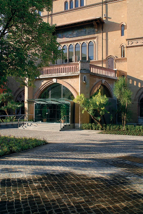
This project was on a fast track and I went to Rome several times over the course of a year. I worked hand-in-hand with clients and contractors there through a daily ritual of sketching then meeting then re-sketching. It wasn't a design-build, but at times it felt that way when I would go out there and work with these amazing Italian craftsmen. For me just the process was about appreciating and understanding a cultural landscape.
In Grounded, a new book on your firm's work, you said, "Green is the future, and landscape architects are critical to meeting the challenge of green cities in the broadest sense." What is a green city? Getting specific, what do landscape architects need to do to occupy a central role in creating this green, urban future?
Everybody has a take on green cities. There's a different perspective whether you're a planner, architect, or landscape architect. To me greening a city just means optimizing land and resources in a way that makes a city livable. To optimize it, it seems to me that you need to have a lot of people on board. If you want to make a city green, it's got to be a true collaboration. And it starts with politicians and local administration. Then, you have to have smart architects designing really smart buildings. You need great engineers designing and building fantastic transit. And you need landscape architects that are able to hold the whole thing together.
Ian McHarg nailed it years ago when he talked about how critical it was that cities understand there were these natural processes all around them and that they were a part of, and that you had to draw these processes through the city and make them real. Then, 20 years later, Jan Gehl talked about a city’s vibrancy, which got better and better with increasing social interaction and integration. For me he's essentially talking about people bumping into one another, striking up a conversation, or maybe just observing people with friends and families or getting a sense of what they're doing or what interests them. I think that these ideas have influenced landscape architects and their approach to green cities. We’ve read McHarg. We’ve read Gehl. And most have read Lewis Mumford, who postulated that cities are ordered through transportation and open space.
You also said the future of cities could belong to landscape architects because people were becoming "weary of the way cities are rolling out or, in some cases, imploding." What do you mean? As an example, how can landscape architects undo the damage of sprawl?
If we're trying to undo the damages of sprawl, then we have to make density interesting. We have to make living in the core of the city interesting. Our firm's from Vancouver, which has been noted around the world as one of the most livable cities in the world. A lot of that has to do with reengaging the public's imagination in living in a dense, downtown environment.
For many cities around the world, there was a great exodus out of the core. Cities were left to the offices and some commercial pursuits. In large part, this didn't happen in Canada to the same extreme it did in American cities, where there was a lot of hollowing out of the centers and there are still many stark reminders of that. What Vancouver ended up doing was coming up with a variety of ways to encourage people to first live in the core, and then, when they started living there, to encourage them to shop there, socialize there, raise their kids there. In 25 to 35 years, it's turned from an uninteresting, fairly unpopulated downtown into one of the most vital downtowns in the world. It's not Tokyo, Shanghai or New York, but it’s pretty good and was partially achieved through this idea of building optimism and imagination. Landscape architecture, quite frankly, was a huge part of achieving this.
At one point in the book you say that landscape architecture in Canada is still struggling a lot. You argue that landscape architects aren't flourishing despite the great projects all over Canada. Why is that? What are the main challenges still facing landscape architects? What are the future opportunities?
I kind of regretted saying that in the book. PFS does very well. There are a lot of firms like ours that do very well. And there are lots of successful individual practitioners. But I do think the profession continues to struggle in Canada. I think it still struggles in the U.S.
I'd be very interested in getting into more of a conversation about this with other practitioners in Canada and the U.S. For me, the profession needs to continue getting out from underneath architecture and engineering. I don't mean that in a disrespectful way to those disciplines. We enjoy working with great architects and great engineers. We seek out multidisciplinary approaches in our work.
For some, though, there is this sense that landscape architects are the butlers or the handmaidens of these larger, more organized, better financed professions. The truth is landscape architects should end up trumping the professions of architecture and engineering.
The solutions we collectively bring to bear as landscape architects on urban problems is seen in a much brighter light because people are tiring of the other solutions. I think people are searching for solutions that reside closer to their hearts. So, in Canada, landscape architects will continue to do well. I'm optimistic about that, but, as a profession, we need to define ourselves a little bit better.
Greg Smallenberg, FASLA, is principal at Phillips Farevaag Smallenberg. Smallenberg, who has 20 years of experience leading large and multidisciplinary teams, is one of the most highly recognized landscape architects in Canada.