.webp?language=en-US)


About Time: Adaptive Management for Coastal Salt Marshes
This team is recognized for their well-executed modeling and monitoring of six wetland restorations in a federally funded multi-year project. Integrating multi-scenario modeling, multi-year vegetation surveys, and satellite data, this project significantly advances a nature-based coastal mitigation research tool. A comprehensive and replicable methodological framework for other coastal work by landscape architects.
The amount of extensive research and tools used to gather information should be applauded.
Awards Jury
-
Designing for local landscape-scale change amid global climate change is a significant challenge for landscape architects. It requires integrating Earth system science tools, such as satellite data and sea level rise projections, with on-site surveying techniques. While surveying has historically been part of landscape practice, the discipline often outsources this work or relies on limited off-the-shelf data products. By creating custom in situ remotely sensed data, designers can recover surveying as a central aspect of practice, contribute to new research frontiers, and participate in large-scale, interdisciplinary coastal infrastructure projects. Nature-based coastal mitigation strategies are emerging as one such crucial research ground.
-
J.B. Jackson famously described landscape as “the art of time.” Change is implicit in this statement. Today, a significant challenge for landscape architects is designing for local, landscape-scale change within the broader context of global climate change. This task requires new mapping and modeling methods that integrate tools and knowledge from Earth system science—such as satellite data and sea level rise projections—with on-site surveying techniques. While surveying has historically been part of landscape practice, our discipline tends to outsource this work or rely on off-the-shelf data products, which are limited by the instruments and institutions that make them. This approach is inadequate for the challenges we face, particularly in rapidly changing coastal areas.
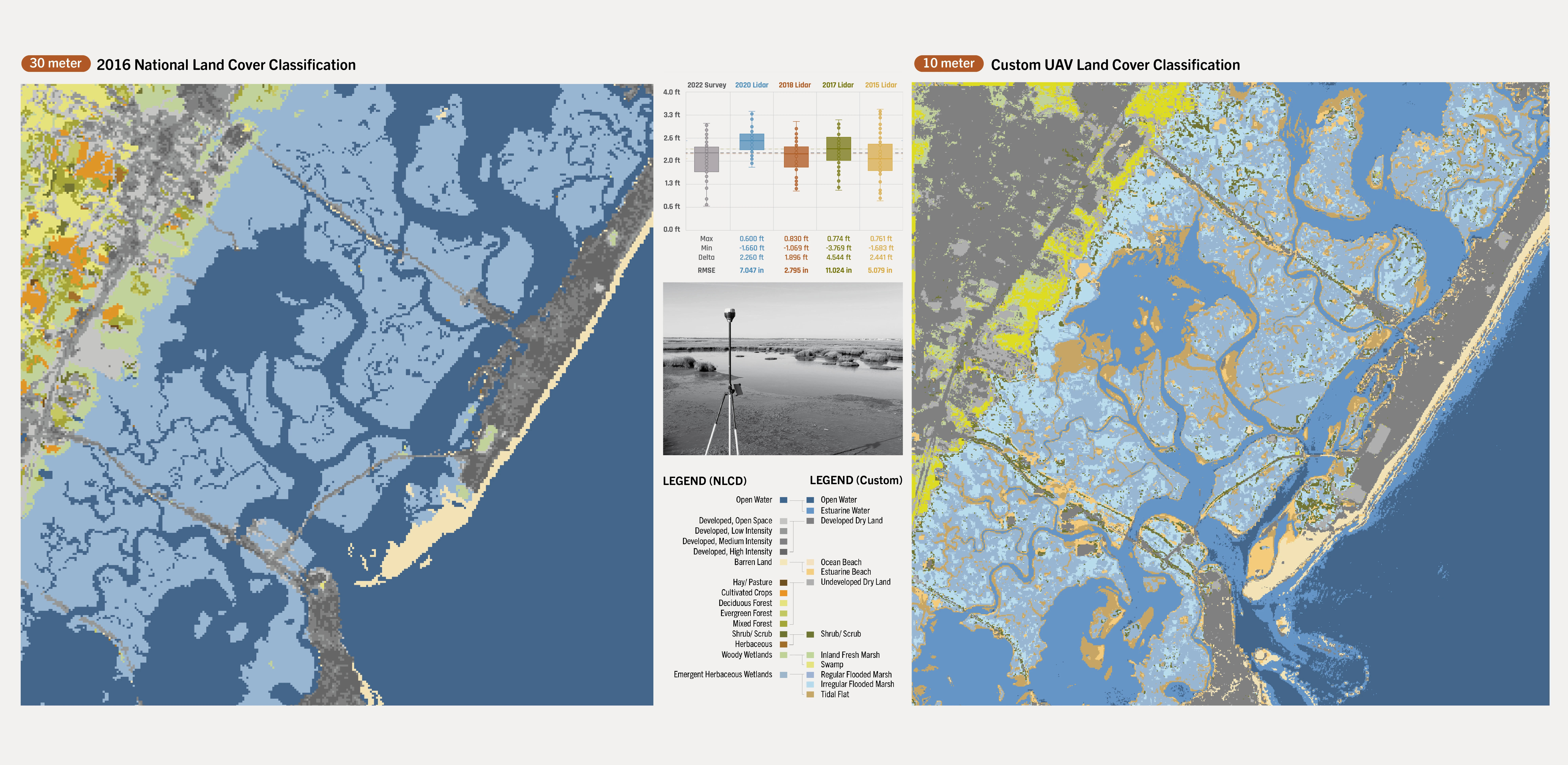
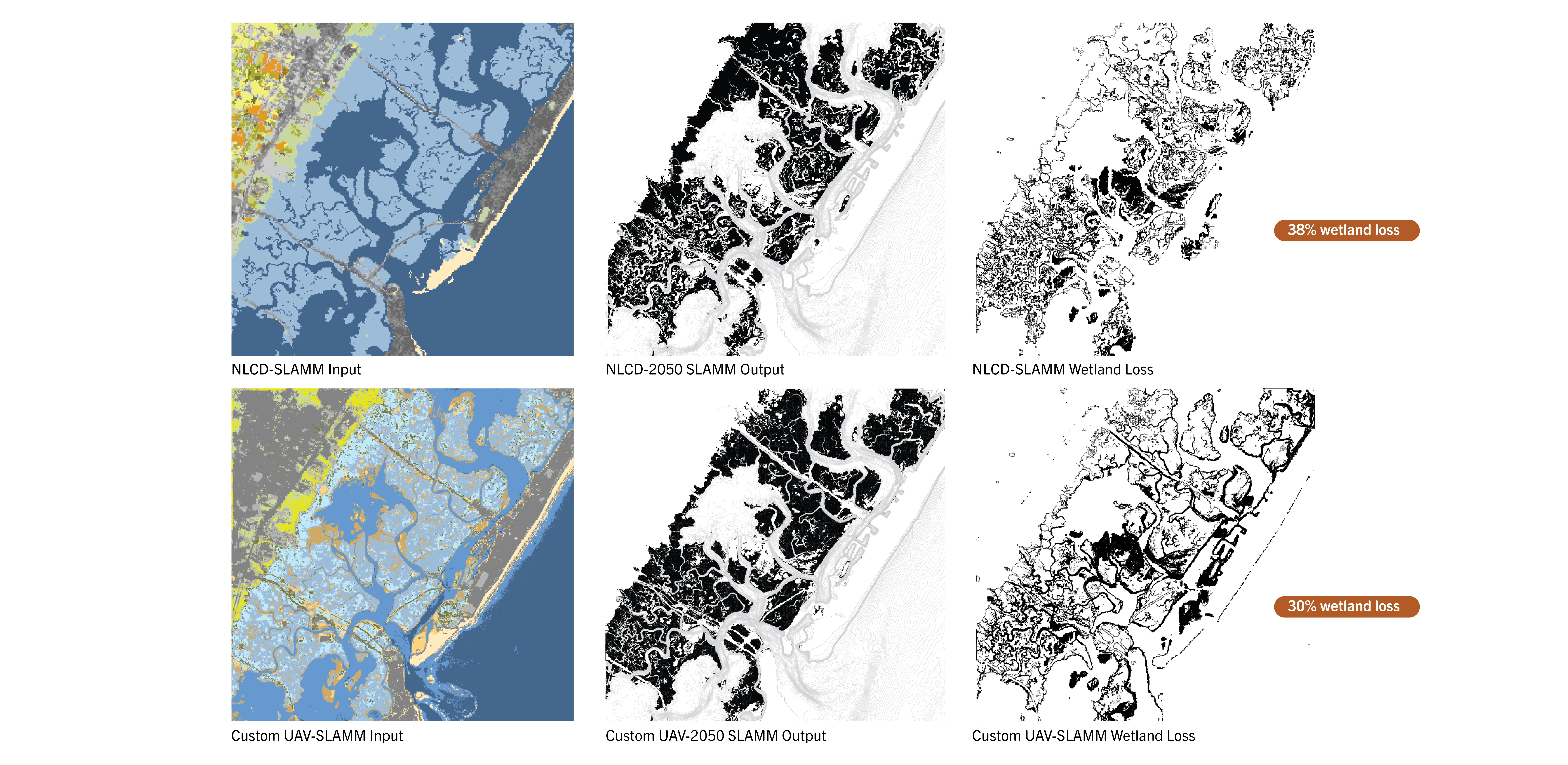
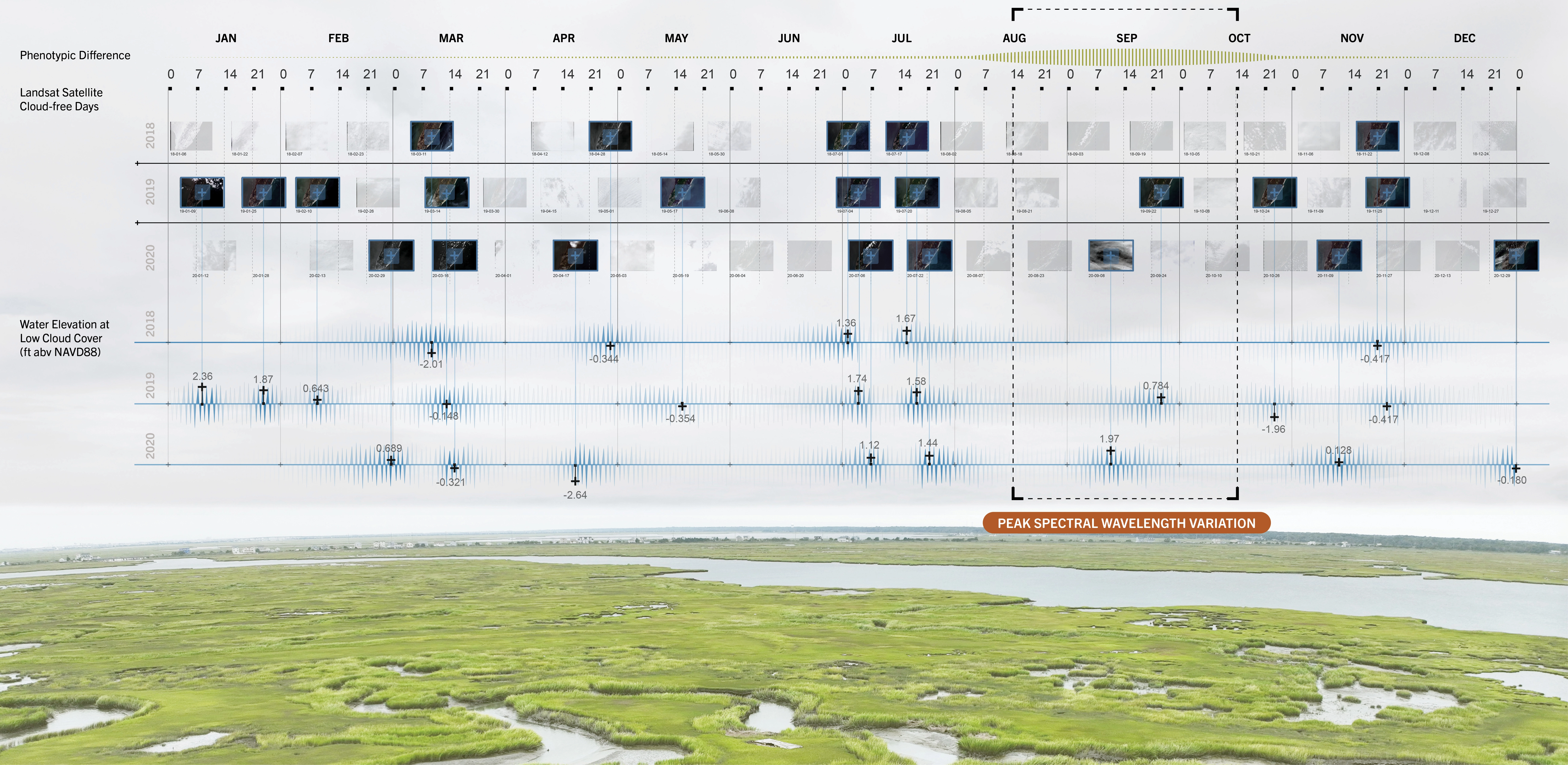
Our team is working with federal and state agencies to model and monitor six wetland restoration sites totaling 500 acres along coastal New Jersey. This work aims to create high-resolution models to determine sediment placement and track salt marsh elevation and vegetation composition over time. Such “nature-based features” are increasingly proposed to address weakened storm defenses, biodiversity loss, and carbon stock depletion resulting from wetland loss. These experimental yet critical features require understanding environmental dynamics across varied spatial and temporal scales. However, coastal wetlands are notoriously difficult to map using satellite-sensed data due to fluctuating water levels and variable spectral characteristics (the wavelengths of materials "seen” by sensors). This difficulty is compounded by the fact that state and federal land cover datasets overlook the complexity of these landscapes in favor of more generalized classifications. Moreover, due to limited access, conventional surveying equipment cannot be used in wetlands.
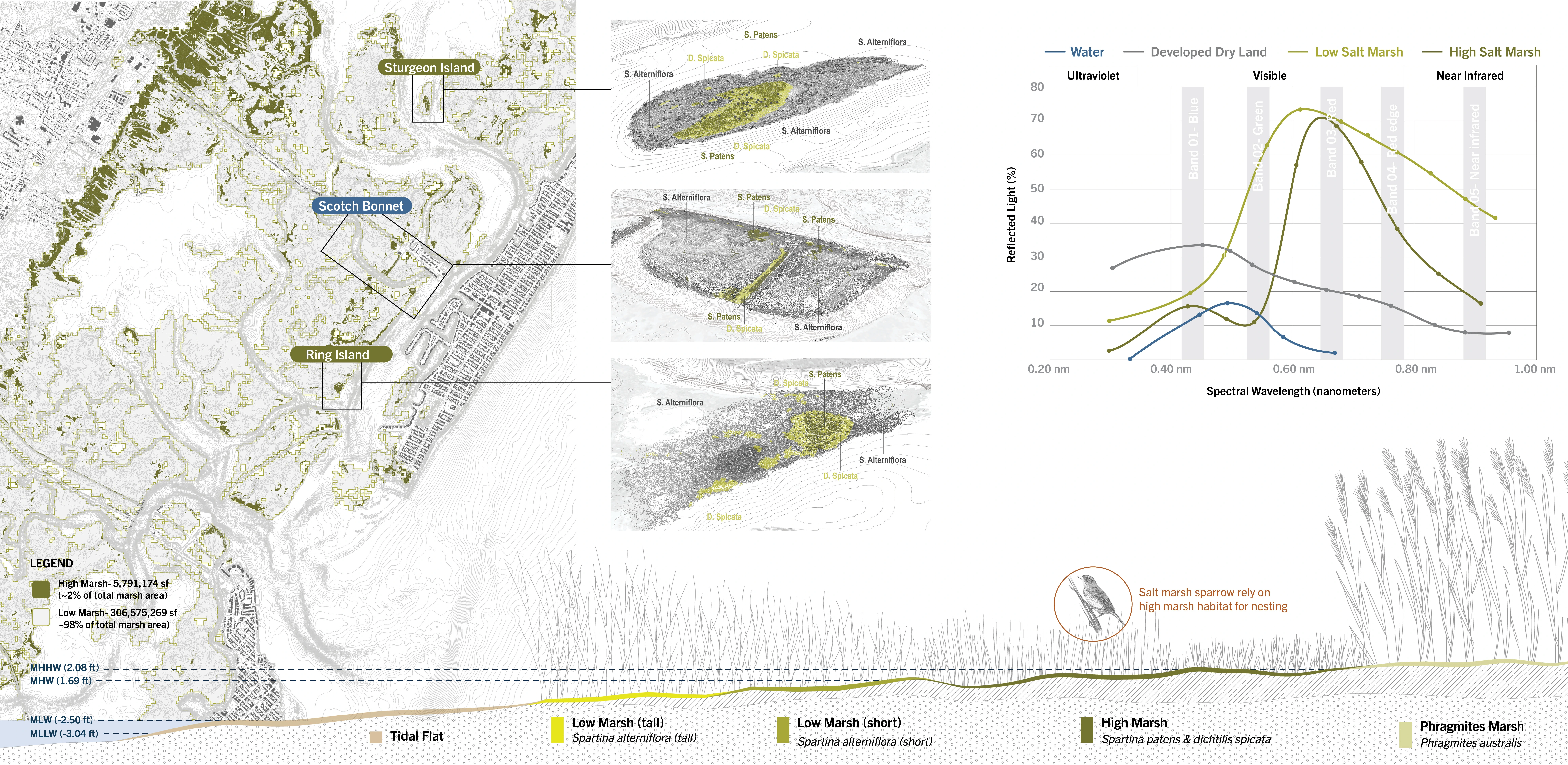
GPS-enabled drones, field survey receivers, and machine-learning algorithms enable novel methods to model and measure landscape changes. With these tools, we developed custom spectral libraries from field-collected data to create land cover maps at a “mesoscale.” The enhanced richness (resolution), reach (coverage), and return (frequency) of custom in situ data better capture the landscape characteristics needed for inputs into various models. These data and models are essential to determine material placement and profiles to support marsh viability. In addition, survey elevations taken from historical sediment placement sites were crucial for establishing target elevations to maximize the creation of high marsh habitats and optimize revegetation rates of low marsh areas. High marshes provide vital nesting sites and temporary refuge for key bird species during floods.
Our team will annually monitor each site to assess performance relative to modeled scenarios. The findings will serve as a blueprint for sediment placement techniques for landscape-scale restorations in other Atlantic Coast locations. Equipped with custom in situ remotely sensed data, designers can recover surveying as a central aspect of practice, contribute to new research frontiers, and participate in large-scale, interdisciplinary coastal infrastructure projects. J.B. Jackson understood that landscapes constantly evolve, but we no longer live in the temporal context he assumed. Landscape architecture is one of the few fields that offer ways to negotiate the misalignment between historical time, human experience, and the planetary time of global heating.
-
- Karen M'Closkey, ASLA - EMLab Director
- Sean Burkholder, ASLA - Project Leader
- Keith VanDerSys - Project Leaders
- Lucy Salwen, Associate ASLA - Research Associate
- Mariya Lupandina, Student ASLA - Research Assistant
- Clarasophia Gust, Student ASLA - Research Assistant
- Zicheng Zhao - Research Assistant
- Shuyi Hao - Research Assistant
- Aaron O'Neil - Research Assistant
Advertisement
Related Awards
Honor Award, Research
Race and the Control of Public Parks
This research uses a century long historical analysis of the public park system in Dallas, Texas, USA to uncover the physical and psychological ways in which public landscapes and the works of landscape architects have segregated urban spaces and how we might fight against these design practices. Through reframing past practice this work seeks to create a method for informing design thought and practices that seek to create a more just built environment.

Related Articles

Landscape Architecture Magazine
LAM Wins Five ASBPE Awards
Landscape Architecture Magazine earned national and regional honors for editorial excellence, publication design, and profile.
Jun 1 2026