.webp?language=en-US)


Envisioning Francisville's Future
The level of analysis is amazing! It's informative and environmentally sensitive, and it provides clear design direction for this community. Very impressive.
Awards Jury
-
'Envisioning Francisville's Future' is a comprehensive analysis and planning project based in the socially, economically, and physically degraded Philadelphia neighborhood of Francisville. Sophomore landscape architecture students undertook a unique, thorough process of studying and applying lessons from planning and design texts, local case studies, an extensive site inventory and analysis; community aspirations; sustainable initiatives, and the McHargian method of regional analysis to develop team-based transit-oriented development (TOD) master plans.
-
Introduction
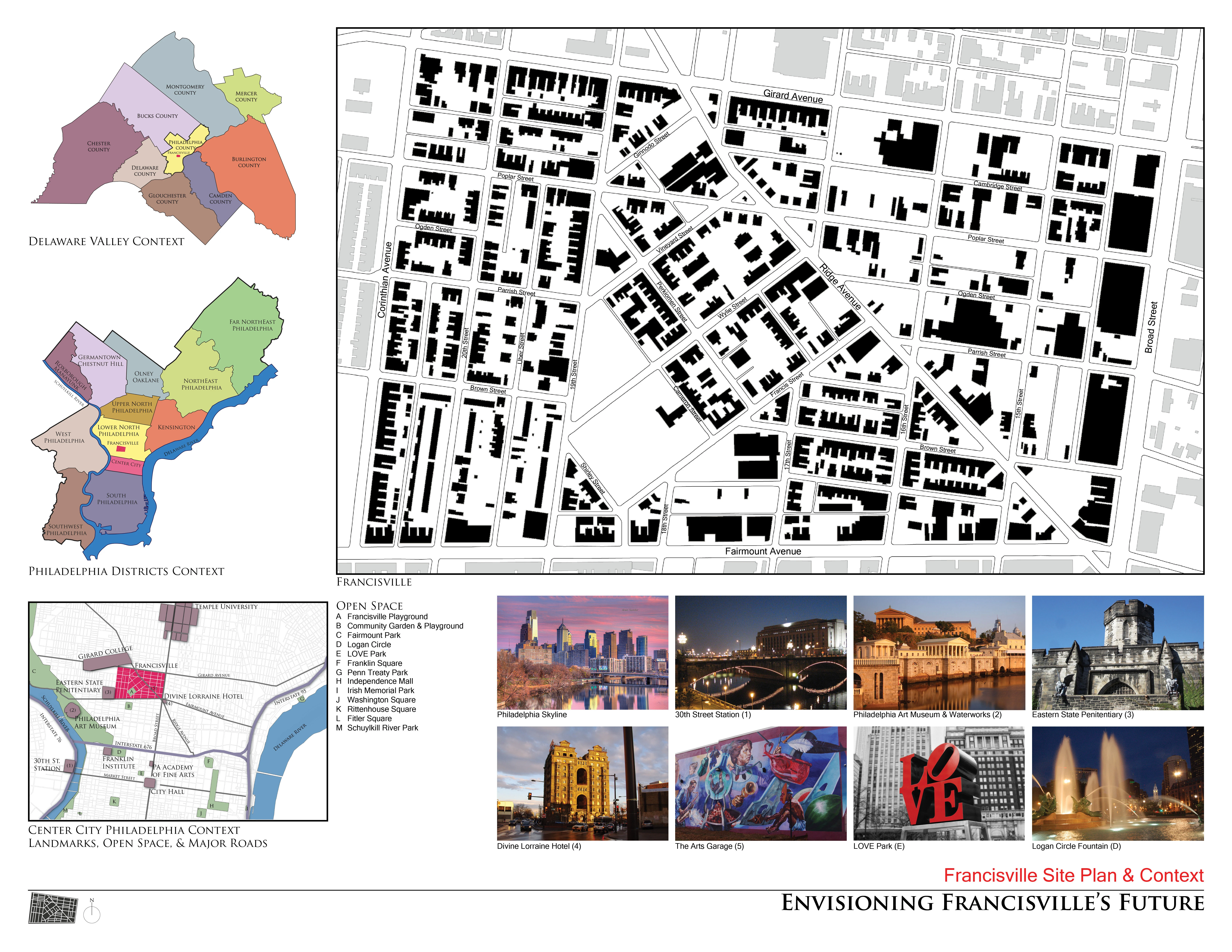
The 'Envisioning Francisville's Future' project is located within the Philadelphia, Pennsylvania neighborhood of Francisville, which has experienced a half-century of social and economic depression including a large residential migration, decay of the neighborhood's physical form, and the loss of significant commercial activity. In 2001, the City began the Neighborhood Transformation Initiative and created many empty lots in Francisville by demolishing dilapidated structures. Since 2003, the Francisville Neighborhood Development Corporation (FNDC) has sought to revitalize the neighborhood by viewing abandoned lots as an opportunity for infill housing, encouraging commercial ventures, and implementing initiatives that aspire to make Francisville the greenest neighborhood in Philadelphia.
Project Goal and Objectives
The goal of this project was to teach undergraduate landscape architecture students the process of developing a sustainable community revitalization plan in an urban setting. Students were expected to understand the social, cultural, economic, and ecological aspects of Francisville; acknowledge recent city planning principles and urban greening initiatives; accomodate residents' needs and desires; and work in a team to incorporate this knowledge in master plans wherein Francisville's urban fabric is restored and a diverse, active community may live in the future.
Environmental and Social Inventory & Analysis
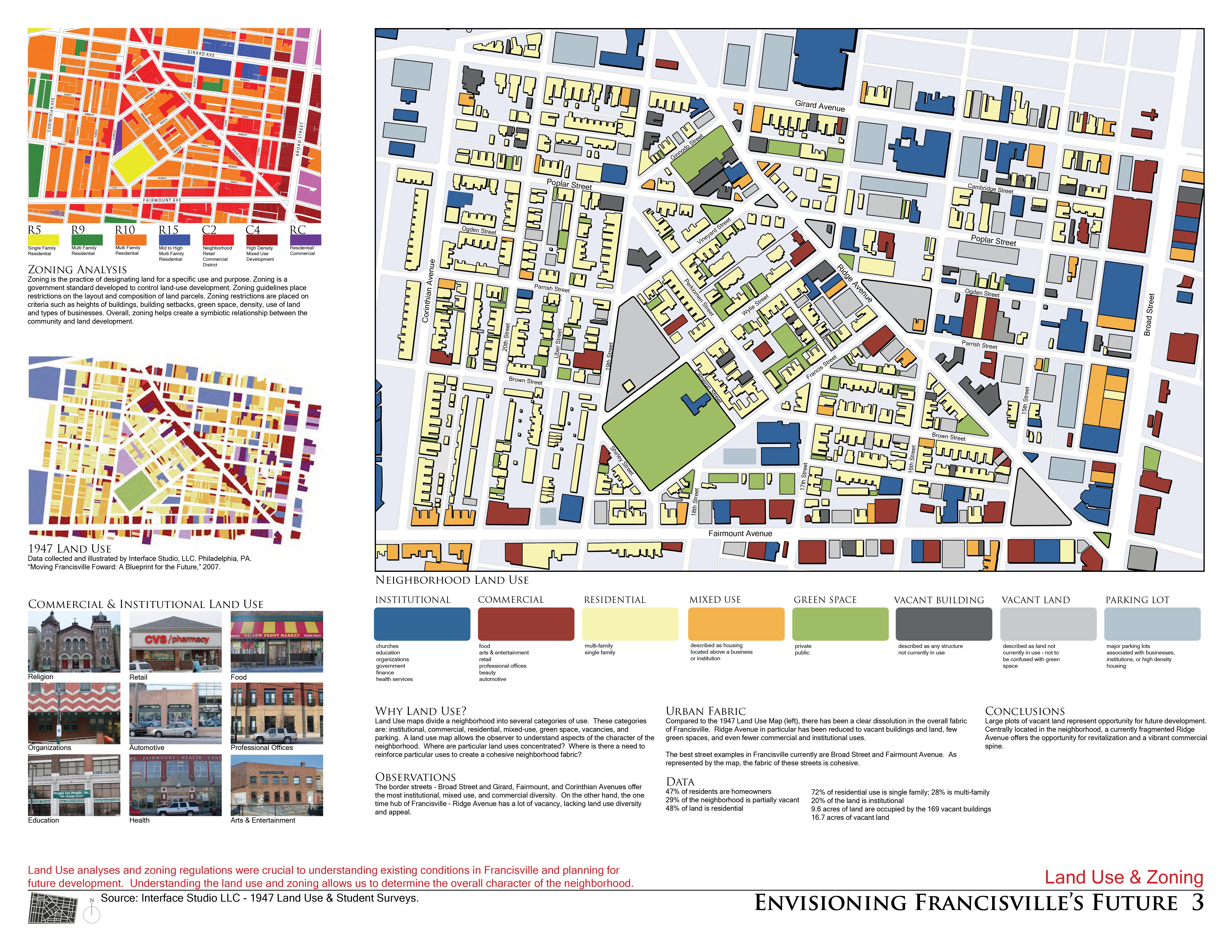
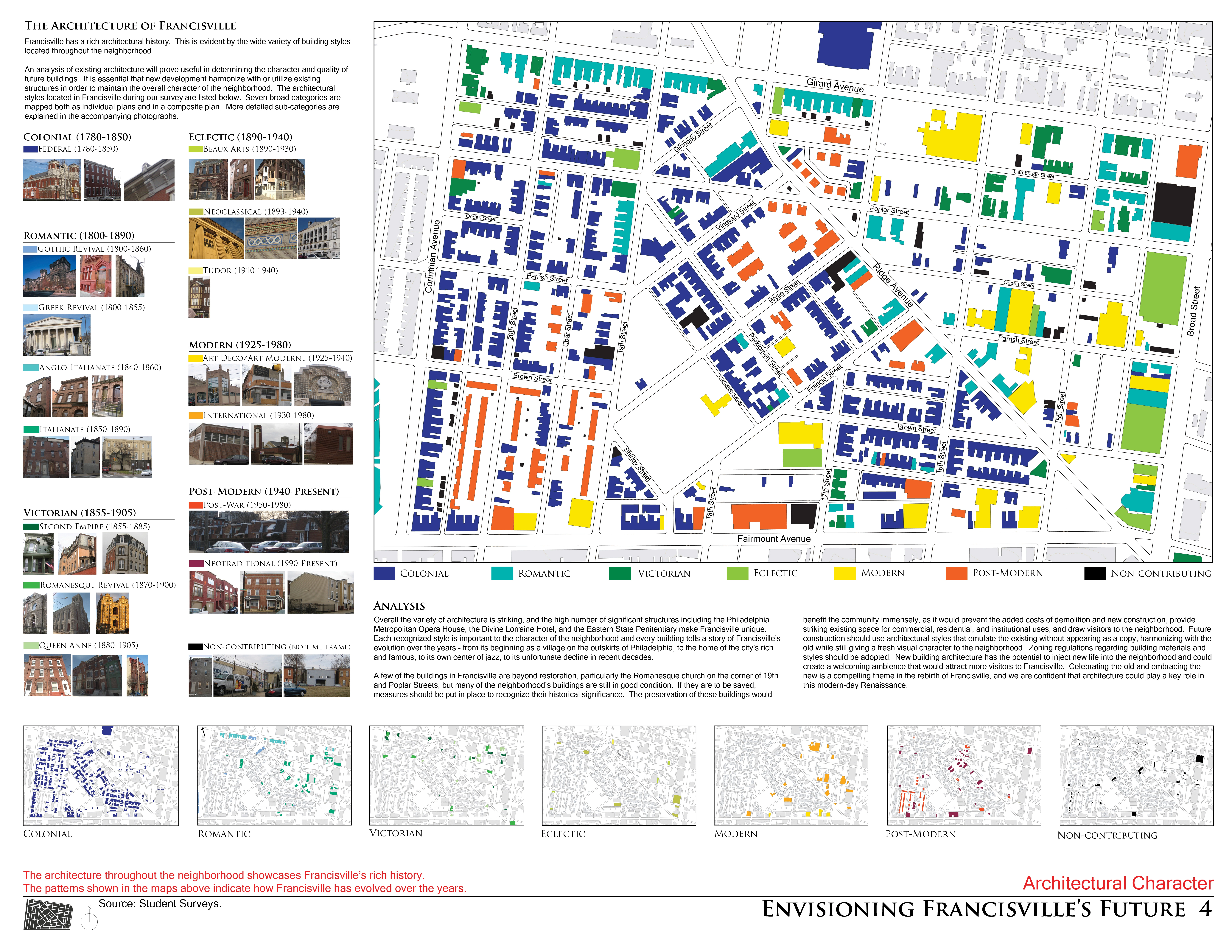
Three tasks comprised the inventory and analysis: first, students were required to read texts that would provide them with theoretical, practical, and site-specific knowledge. Second, students undertook investigations of local precedents focusing on dense urban form, a viable commercial corridor, and the integration of a green network within an urban fabric. Third and finally, students completed an extensive inventory and analysis of various aspects of Francisville and Philadelphia from zoning codes to hydrology and land use to architectural style.
Studio Readings
Three texts guided the analysis, inventory, and design efforts of this project. Kevin Lynch's The Image of the City presented students with a framework to understand residents' image(s) of Francisville in terms of landmarks, edges, districts, nodes, and paths, and how the image may be improved or enhanced by design. The Next American Metropolis: Ecology, Community and the American Dream by Peter Calthorpe provided the historical and theoretical reasoning for encouraging transit-oriented development (TOD) as well as the practical guidelines and criteria for implementing them. A comprehensive master plan produced in 2007 by Interface Studio, LLC., of Philadelphia, entitled “Moving Francisville Forward: A Blueprint for the Future” supplied students a substantial body of work from which to learn and verify the history and future desires of the community.Case Studies
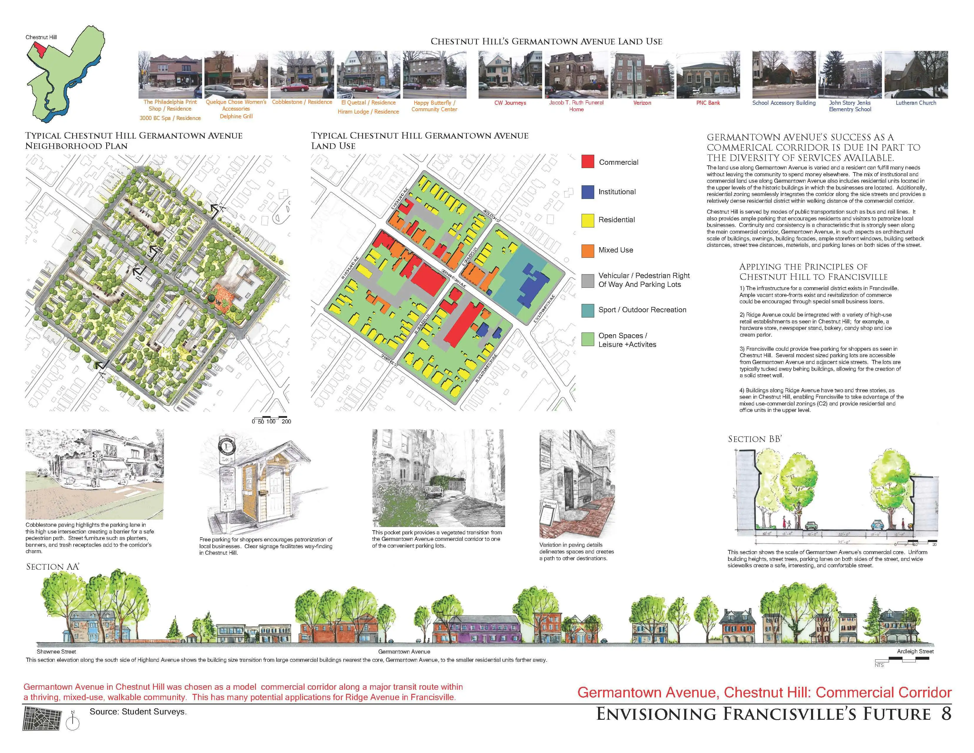
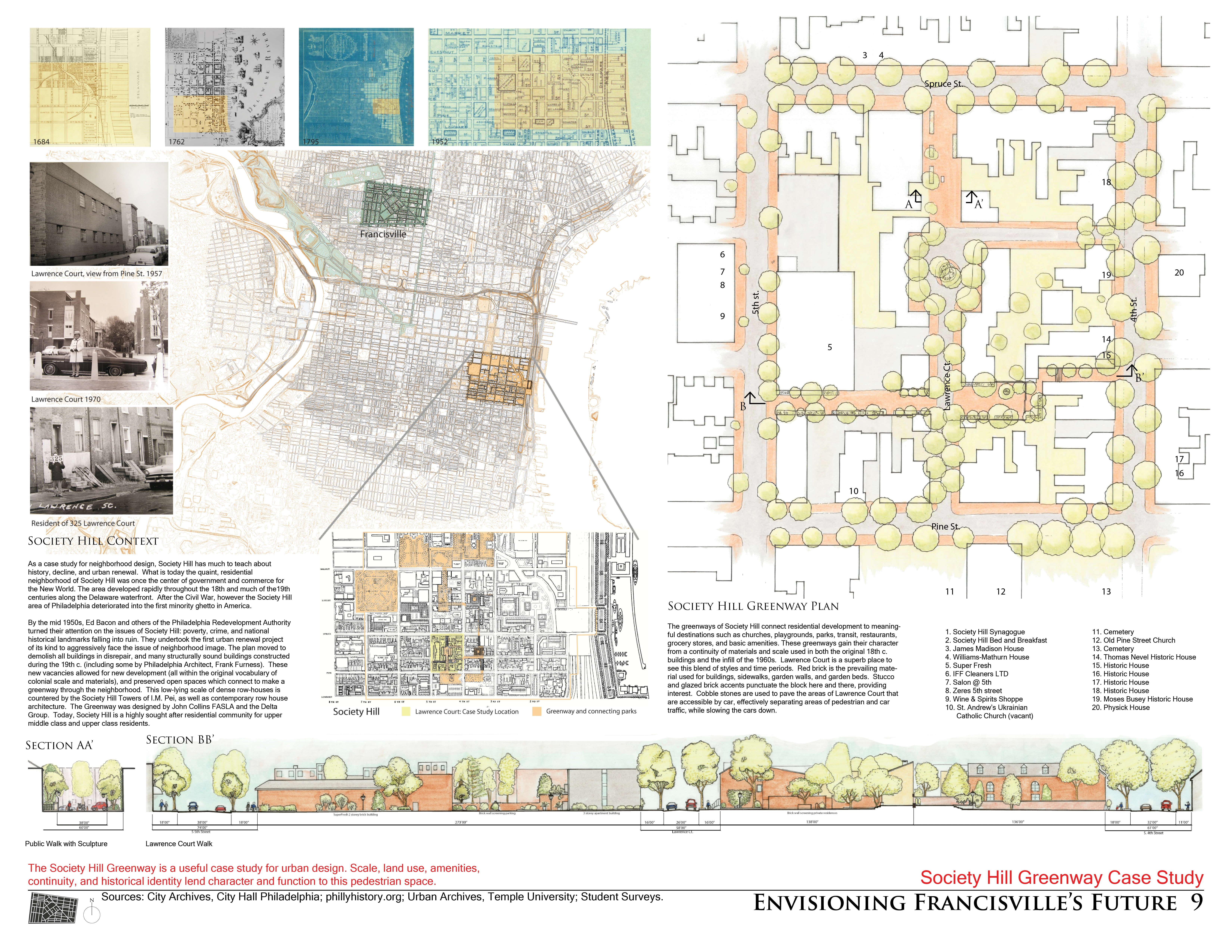
Three case studies were performed in separate Philadelphia neighborhoods, each serving as a model for a specific aspect of design that could be adopted and adapted to Francisville. First, the neighborhood of Fairmount, adjacent to Francisville, was chosen as a model of urban density for its closely spaced two- and three-story row homes that create a solid street wall necessary to making Francisville a place again. Students were required to field-measure and hand-draft one neighborhood block to understand its physical dimensions. Chestnut Hill was chosen as a model for its thriving mixed-use, walkable commercial corridor - Germantown Avenue. Continuity there is seen in the scale of buildings, awnings, facades, ample storefront windows, uniform building setback and street tree distances, locally-sourced building materials, and on-street parking. Students were required to document the surrounding context, materials, select dimensions, and variety and location of uses using photographs, diagrams, and digital or hand drawings. A similar method was employed when students analyzed Society Hill, a model of an urban green network within an historic residential neighborhood. Like Francisville, it was once a strong commercial area that has suffered population decline, poverty and urban blight, and has been the subject of a redevelopment plan. Now a sought-after address for upper-middle and upper-class residents, this community successfully includes open space and greenway corridors, mixed-use commercial, institutional and residential areas and human-scaled street furniture.Site Inventory and Analysis
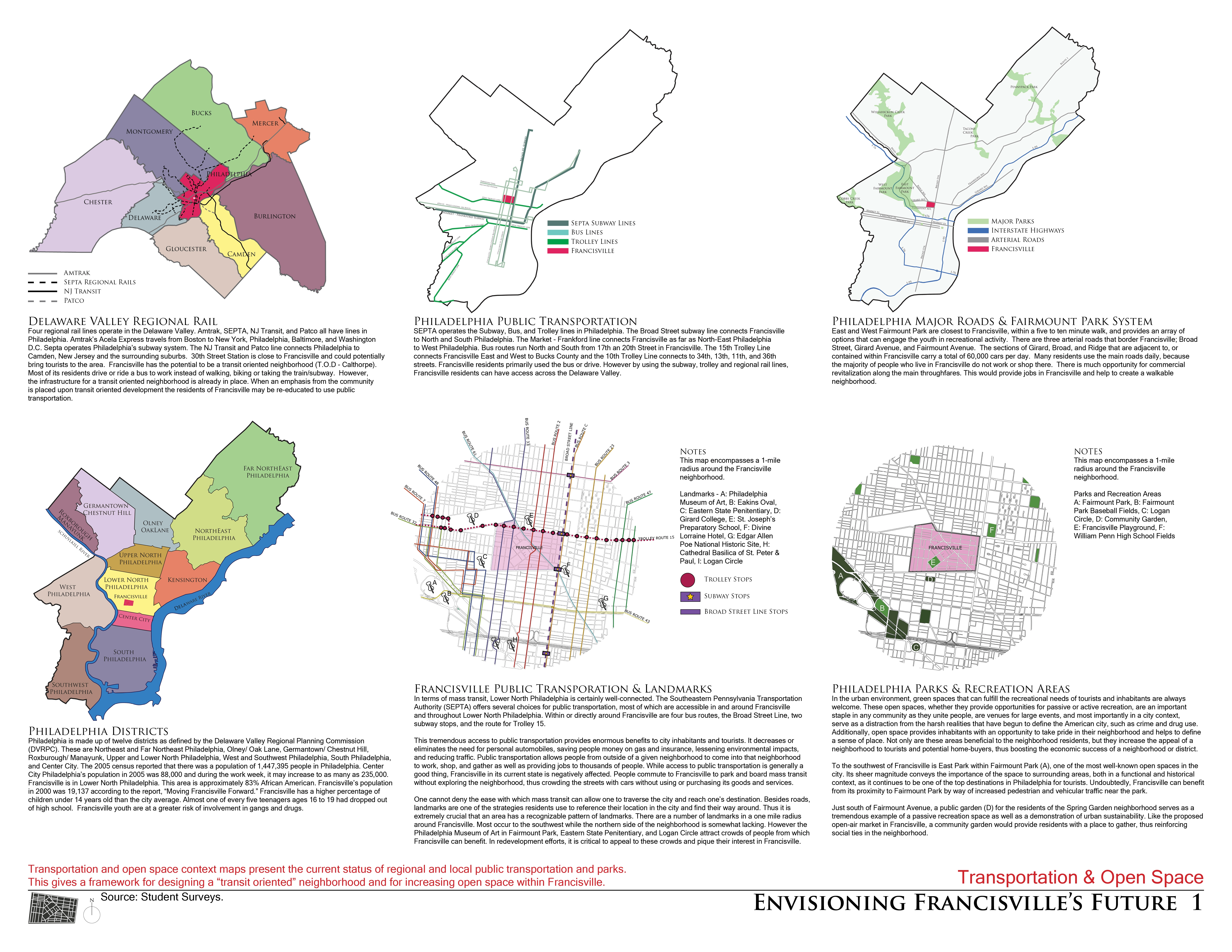
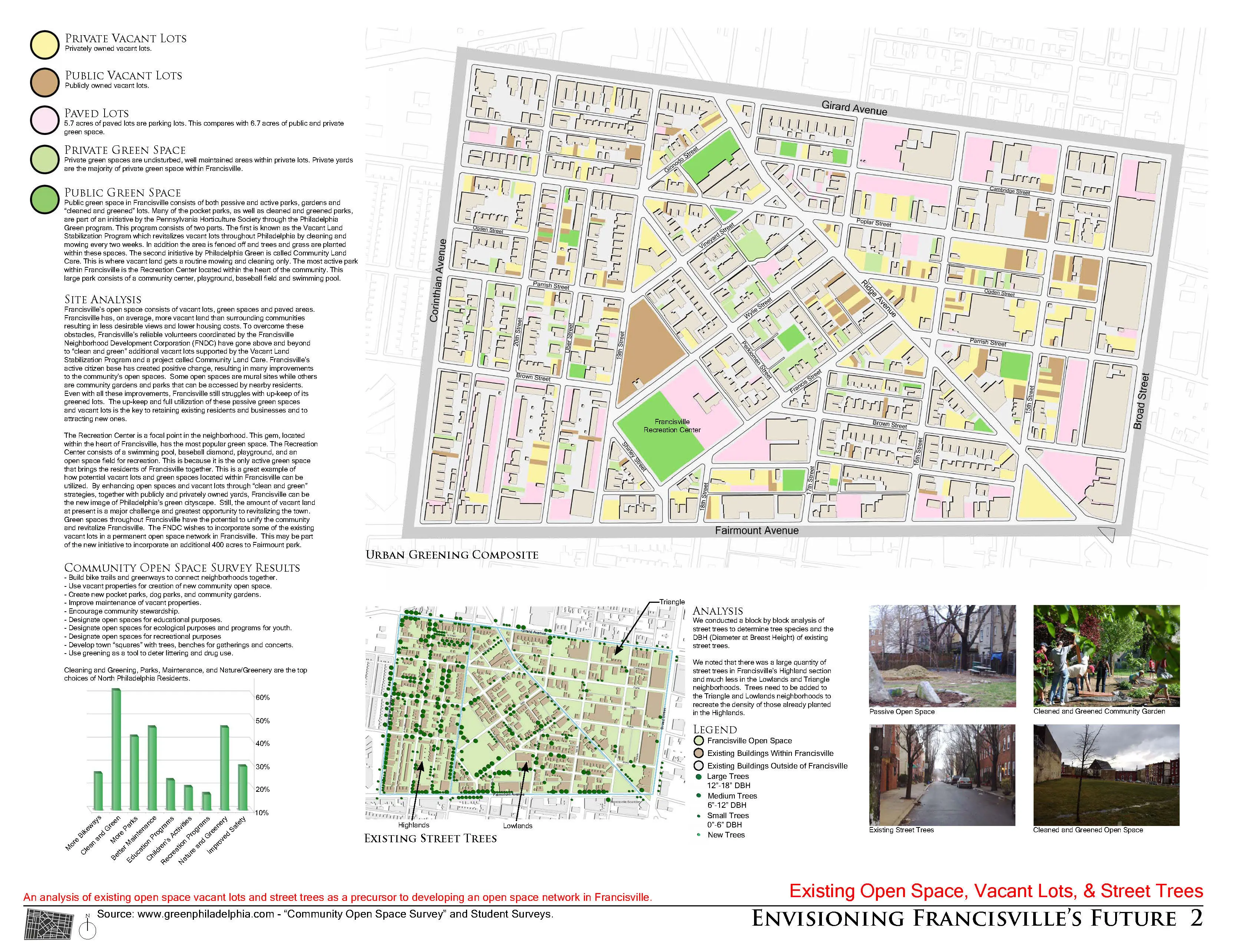
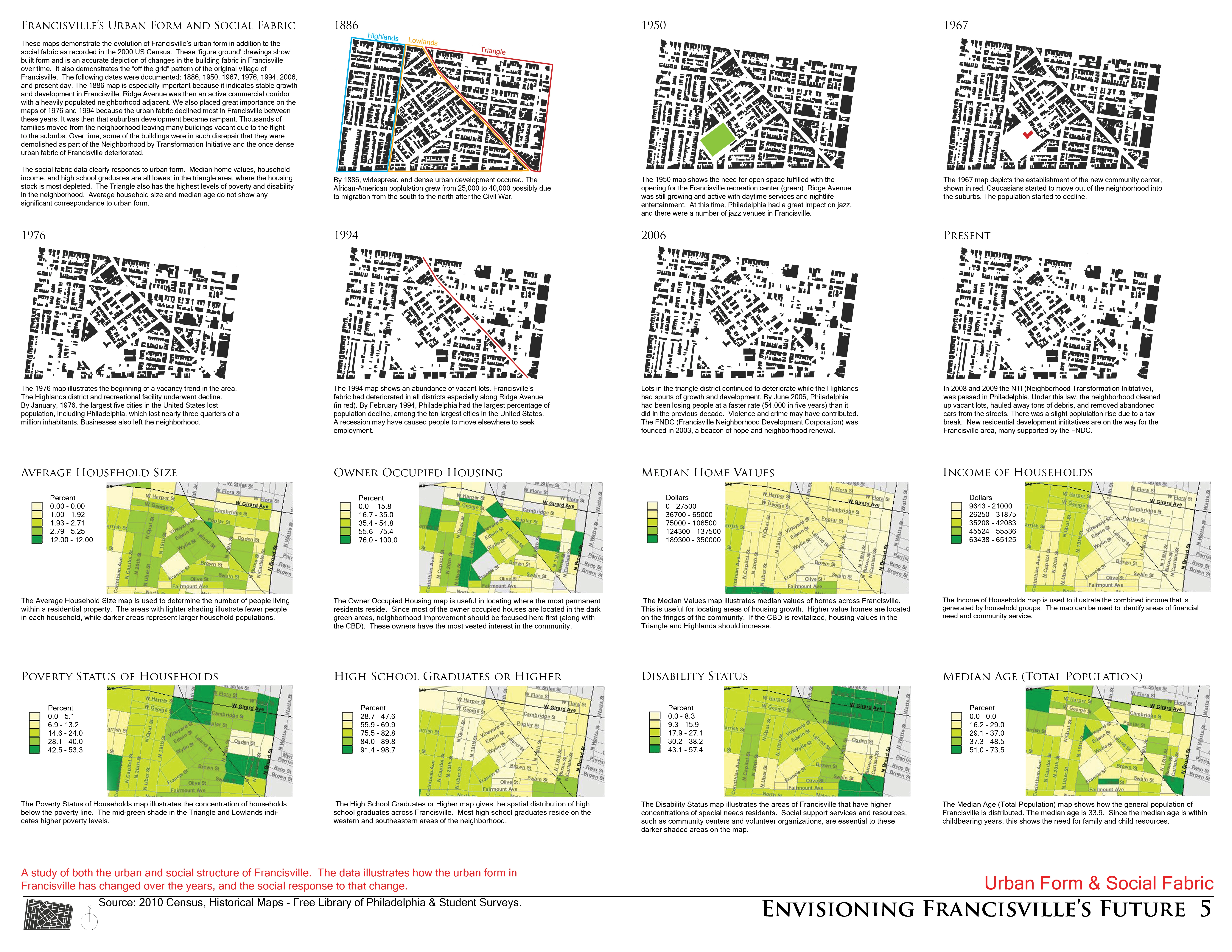
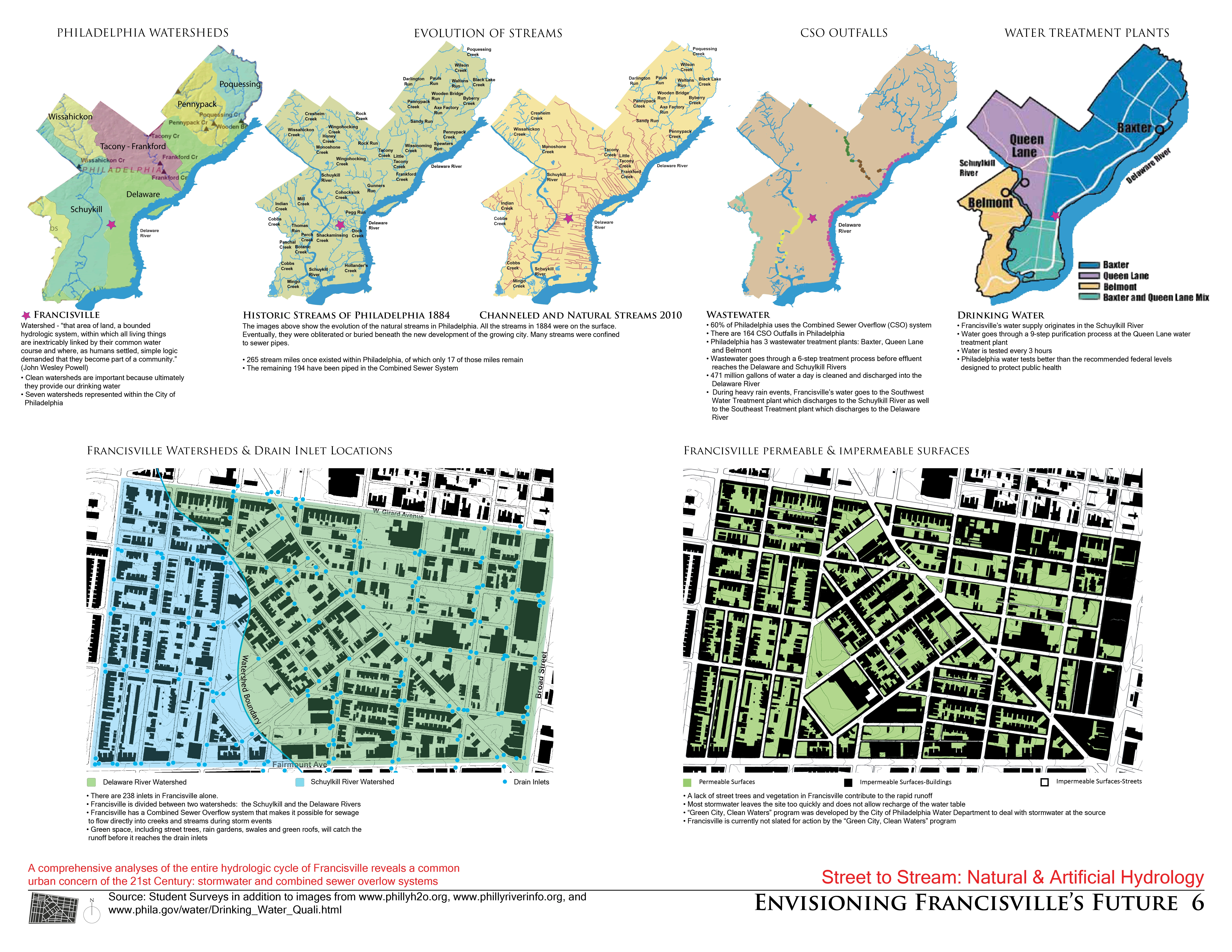
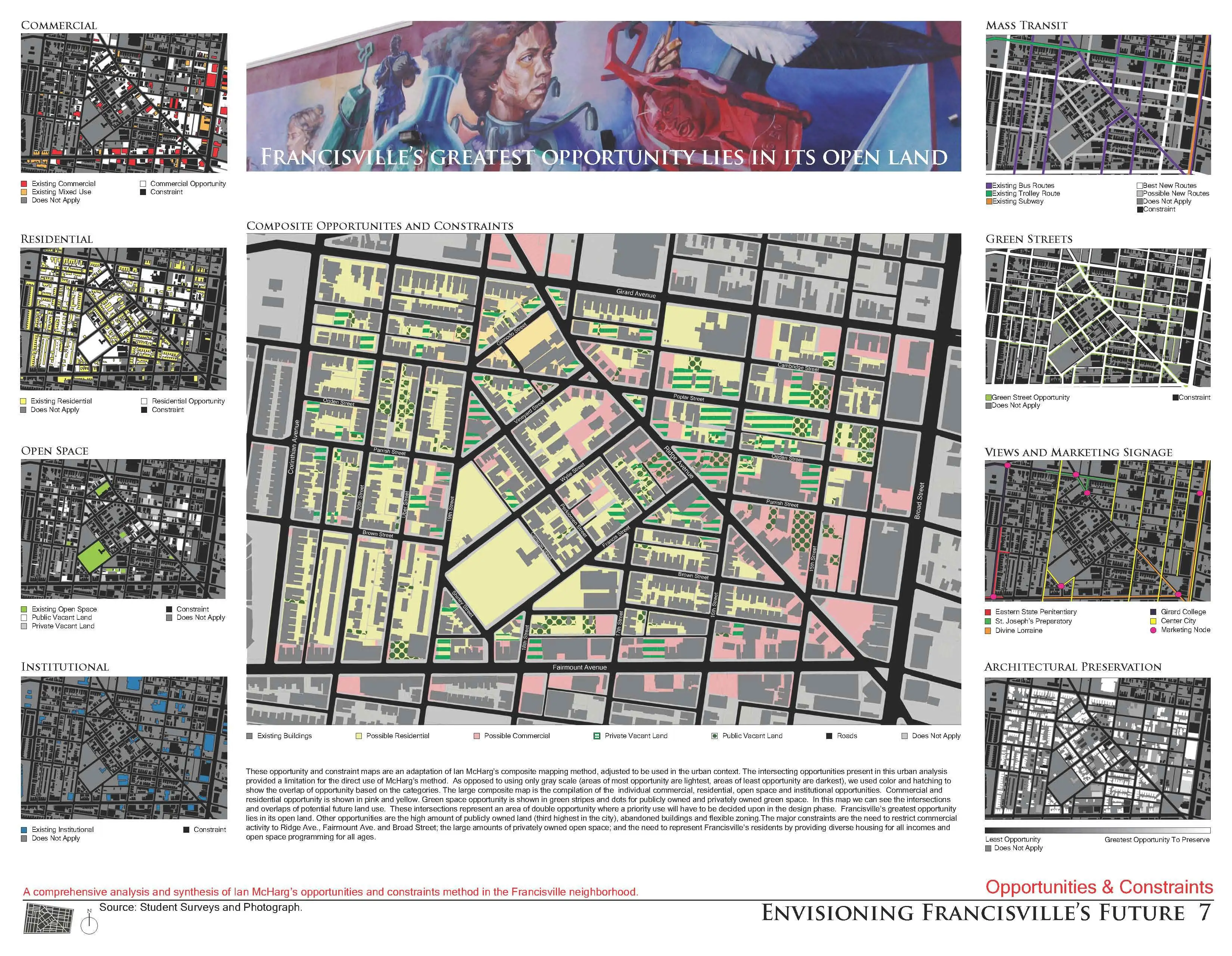
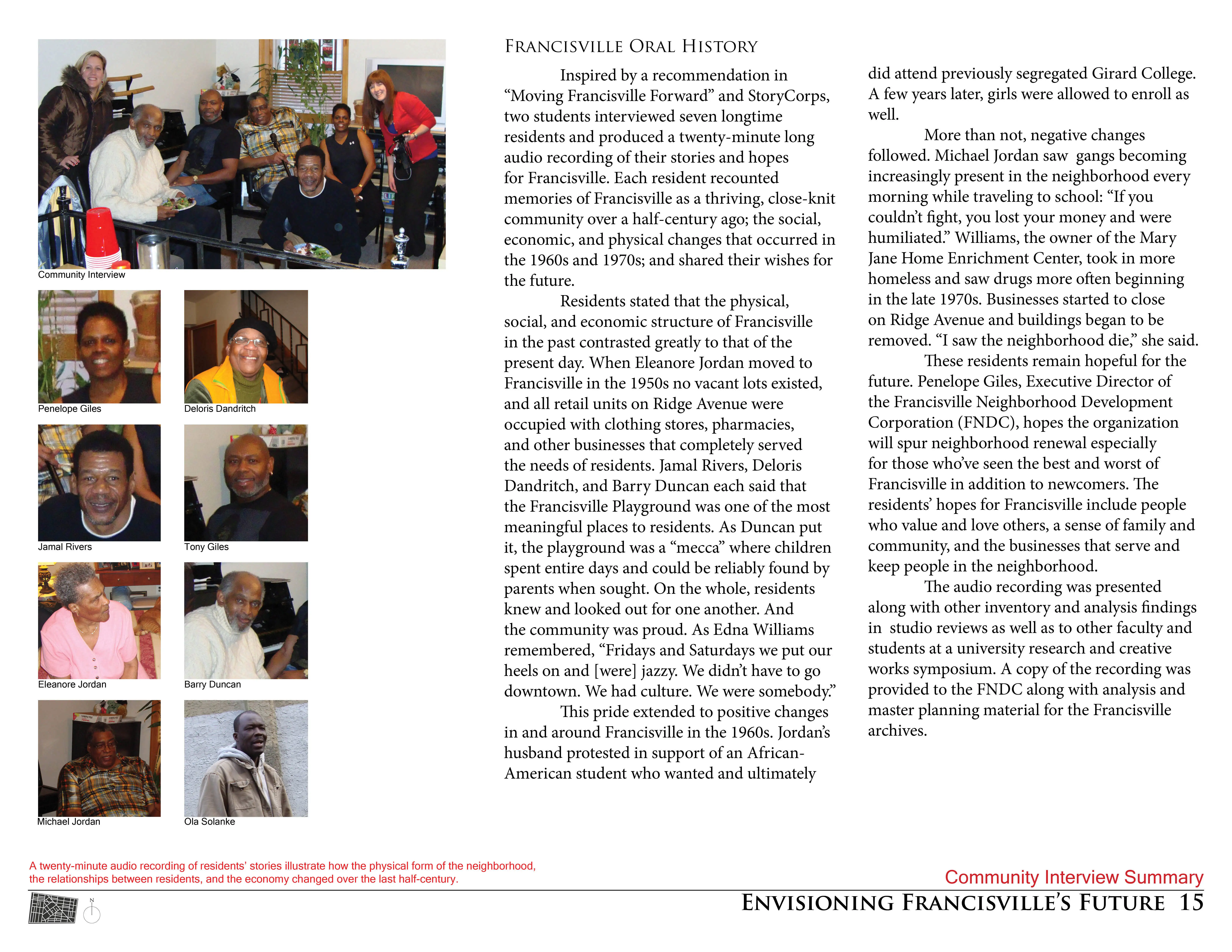
A comprehensive site inventory and analysis was undertaken to understand the social, ecological, and physical aspects of Francisville. Unless otherwise noted, students retrieved information via site visits and GIS maps and presented their findings digitally using a variety of computer programs. Regional, City, and Neighborhood Context inventory and analyses encapsulated scalar relationships including but not exclusive of mass transit, open space, community and civic organizations, land ownership, landmarks, physiographic regions, and surface waterways. The evolution of the urban fabric traced the fluctuation of building density within Francisville at eight distinct times using figure-ground drawings created from maps at the Philadelphia Free Library. Landforms examined topography, building height, views, and the urban heat-island effect. Data from the U.S. Census Bureau including poverty status of households, owner occupied housing, and disability status of residents was mapped to understand where various types of housing and services might be concentrated in design. The Philadelphia Zoning Code was investigated to grasp the dimensional parameters within which the students must design. Land use was examined on scales ranging from the neighborhood to street showing the large-scale concentrations and patterns of land uses to the small-scale variety of retail, office, and service-oriented businesses that exist in Francisville. The architectural style of the buildings within Francisville were catalogued and examined to identify the various styles and the locations in which they are concentrated. Using information from “Moving Francisville Forward”, site visits, and the City of Philadelphia, the open spaces between buildings were categorized in terms of various forms of ownership, care, and surface condition. The artificial and natural hydrology of Philadelphia and Francisville were analyzed in terms of their need and potential for introducing stormwater BMPs and envisioning Francisville as the greenest neighborhood in Philadelphia. Finally, some of Francisville's residents shared their memories and dreams for the neighborhood in interviews that were recorded and edited into a twenty-minute long audio recording.Community Involvement
Beyond these recordings, Penelope Giles, Executive Director of the FNDC, gave students a guided tour of Francisville and later reviewed the above analysis with a member of the Philadelphia City Planning Commission and an Associate of Interface Studio. Students incorporated the juror's comments into opportunities and constraints drawings that were used to guide infill design. Students began this phase of design by applying the McHargian method of regional analysis and site selection outlined in Design with Nature.Master Plans
Eight teams comprised of three to four students created master plans that sought to synthesize the above analysis in the design studio. Two are included within this submission:
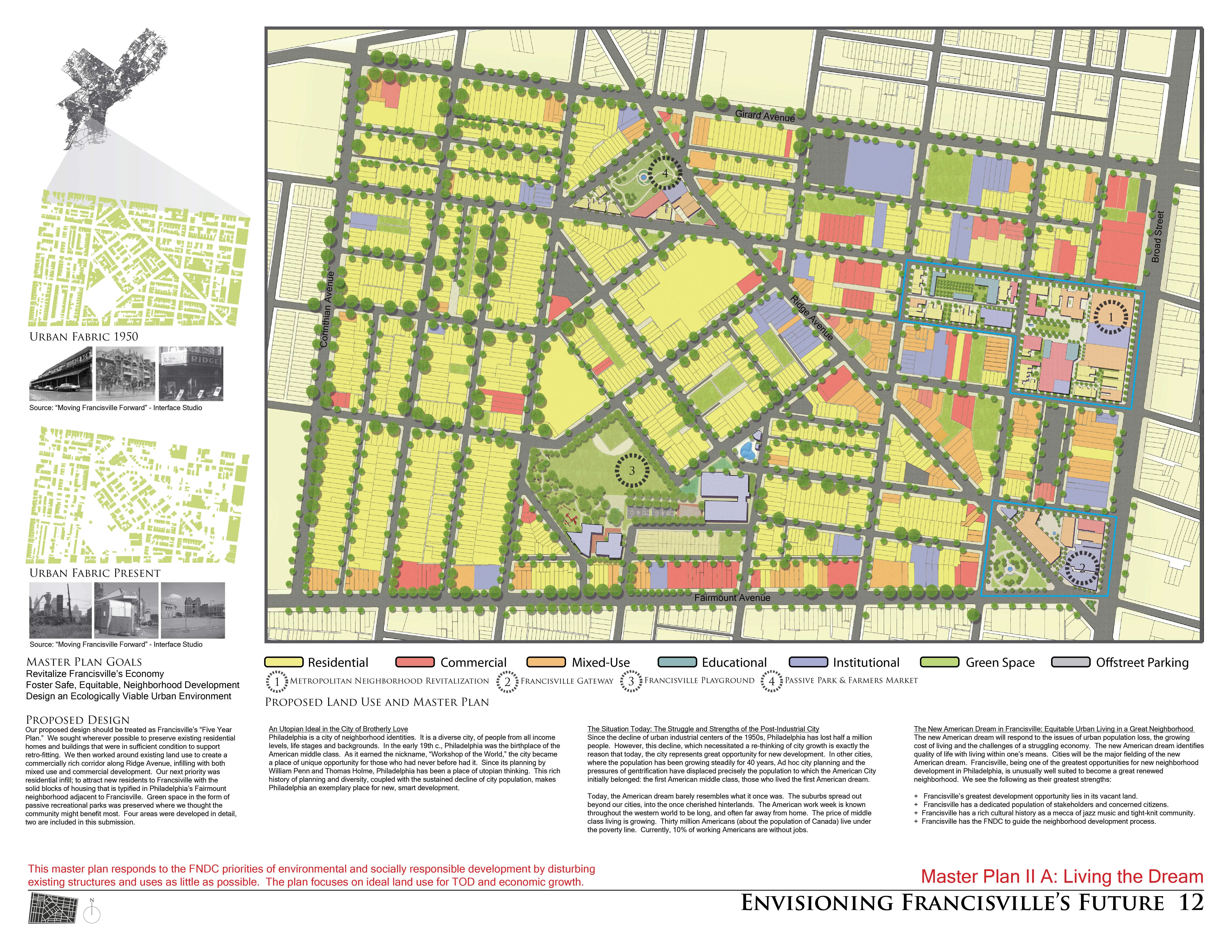
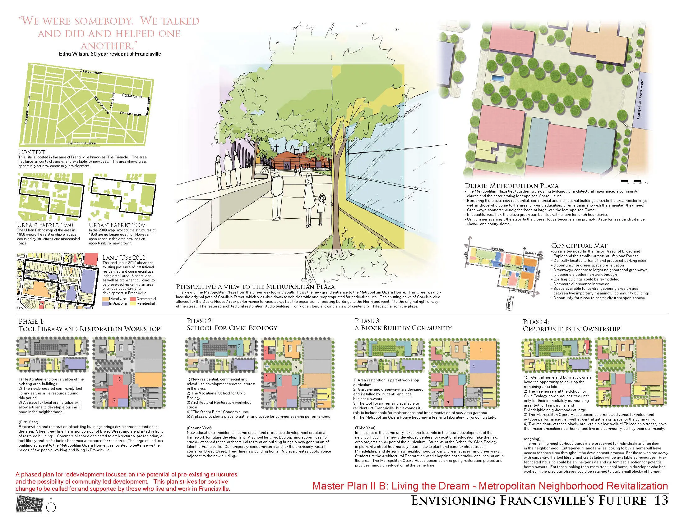
- 'Living the Dream' is a five-year masterplan comprised of phases that structurally retrofit commercial and residential buildings to attract new residents and businesses, preserve green space for passive recreational parks, and locate training facilities where citizens can be taught and empowered to sustain the community. More detailed designs of the Metropolitan plaza area and a gateway to Francisville are also included.
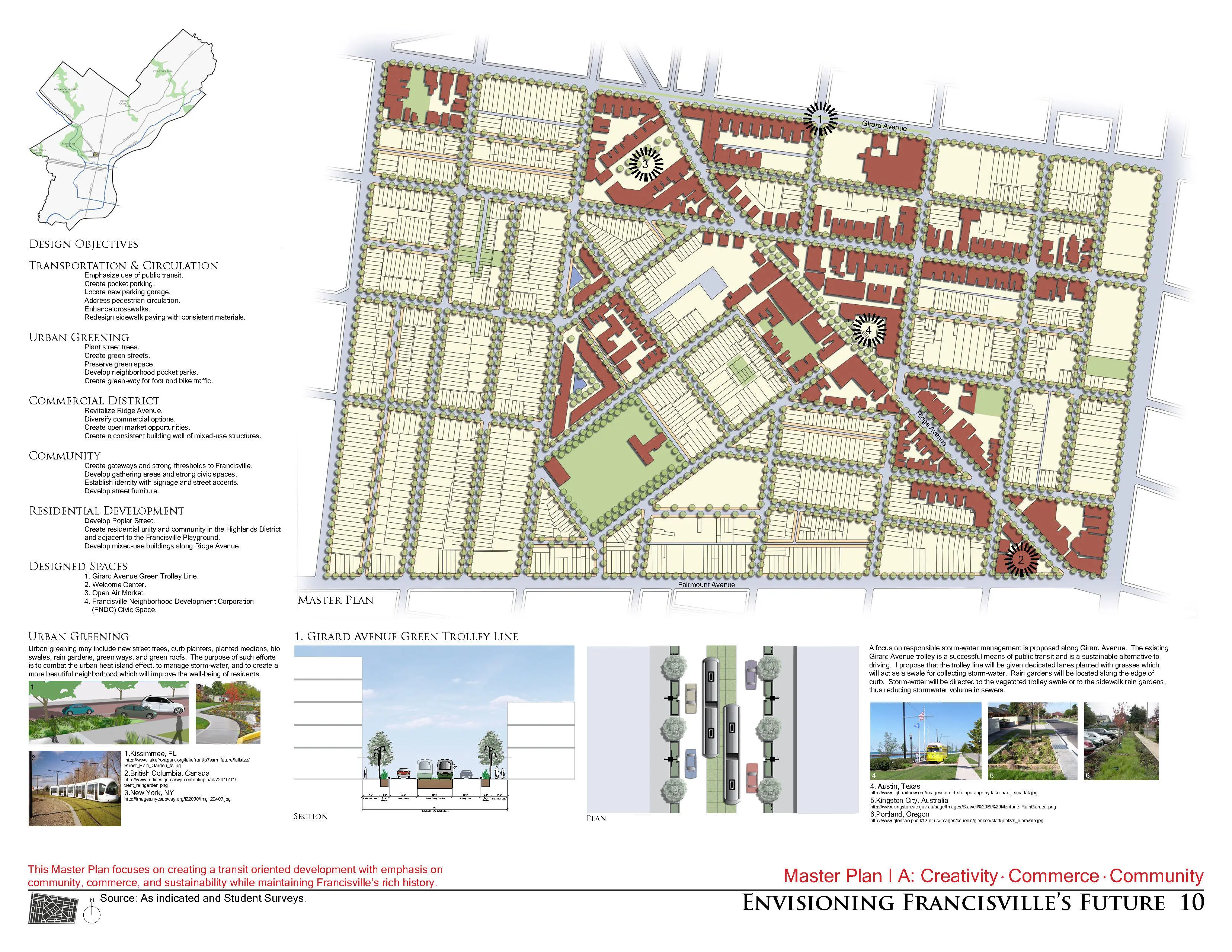
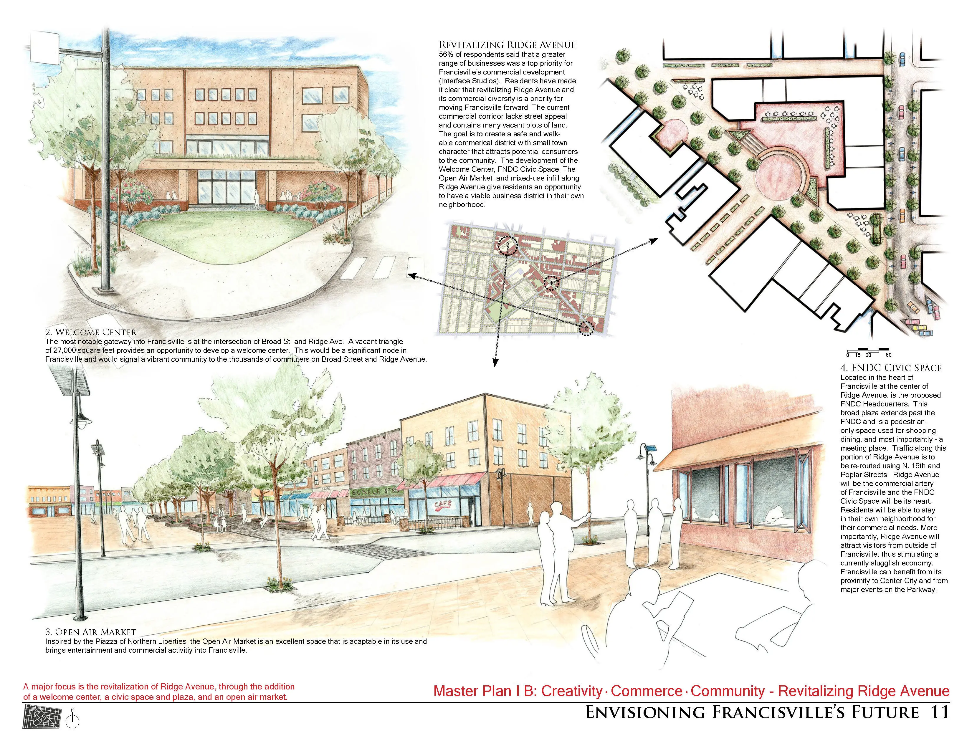
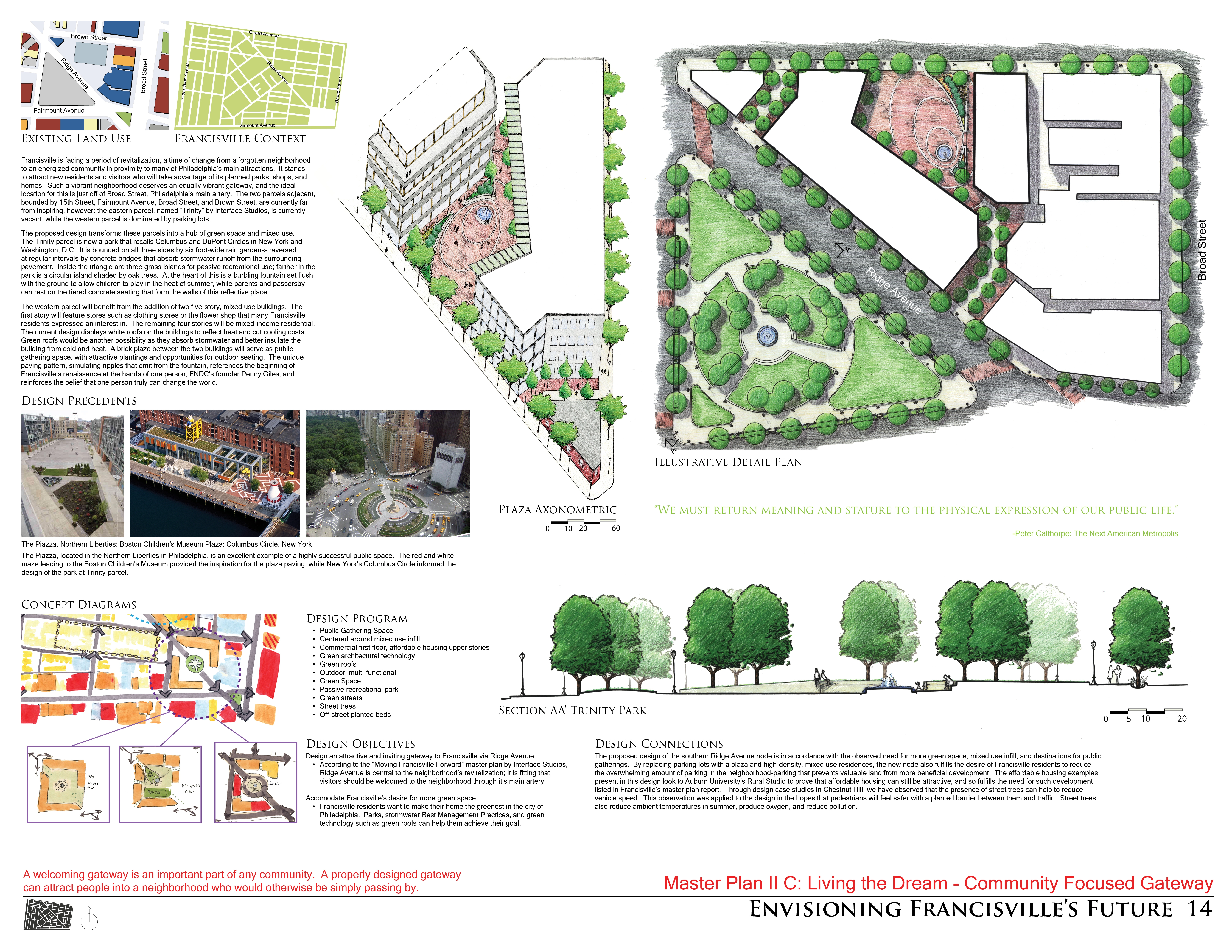
- 'Creativity, Commerce and Community' places emphasis on public transportation, the design of pocket parks, and enhancement of pedestrian circulation through use of crosswalks and consistent sidewalk and street furniture materials. An Urban Greening Plan will create green streets (street trees, rain gardens, and curb planters) through the preservation of green space during development. A welcome center serves as a gateway node for the revitalized Ridge Avenue commercial corridor along which an open air market and FNDC Civic Space are proposed.
These master plans and neighborhood designs were presented before members of the community in Francisville for their feedback. All of the above was made available to the FNDC in hard copy and digital form at their request, and to maintain and further the interest in revitalizing Francisville. Students also spent a day working on two community-service projects that were planned outside of and prior to the studio: setting posts in a vineyard and installing fence rails and a trellis in the community garden.
-
Francisville Neighborhood Development Corporation (FNDC)
Penelope Giles, Director;
Tony GilesCity of Philadelphia
David Fecteau, PlannerInterface Studio
Mindy Watts, Planner, Associate
Advertisement
Related Awards
Award of Excellence, ANALYSIS AND PLANNING
Rethinking Taj Heritage Corridor: A River as Historic Connection
Locates between Taj Mahal and Agra Fort, this proposal on Taj Heritage Corridor aims to reestablish the image of riverfront that was destroyed during the problematic reclamation project in 2002-2003. By creating a recreational water treatment canal along the original river bank, a landscape urban infrastructure is proposed to visually connect the city's scattered historic riverfront monuments and create public space for both tourists and local community. With a full respect of the silently mild image on Yamuna River in Agra, the design proposed an educational space that highlights the inherent dialogue between environment and history. Through analysis in different scales with the understanding of extreme site conditions, political background, and feasibility potentials, the design demonstrates the strong capacity of landscape intervention in resolving the complex contradiction between modernity and historic environment conservation.