.webp?language=en-US)


Dust to Dust
Laura Bryant, Student ASLA; Chelsea Vargas, Student ASLA

The narrative is compelling and the attention to detail is excellent. A beautiful, simple design that addresses a real need for our time.
Awards Jury
-
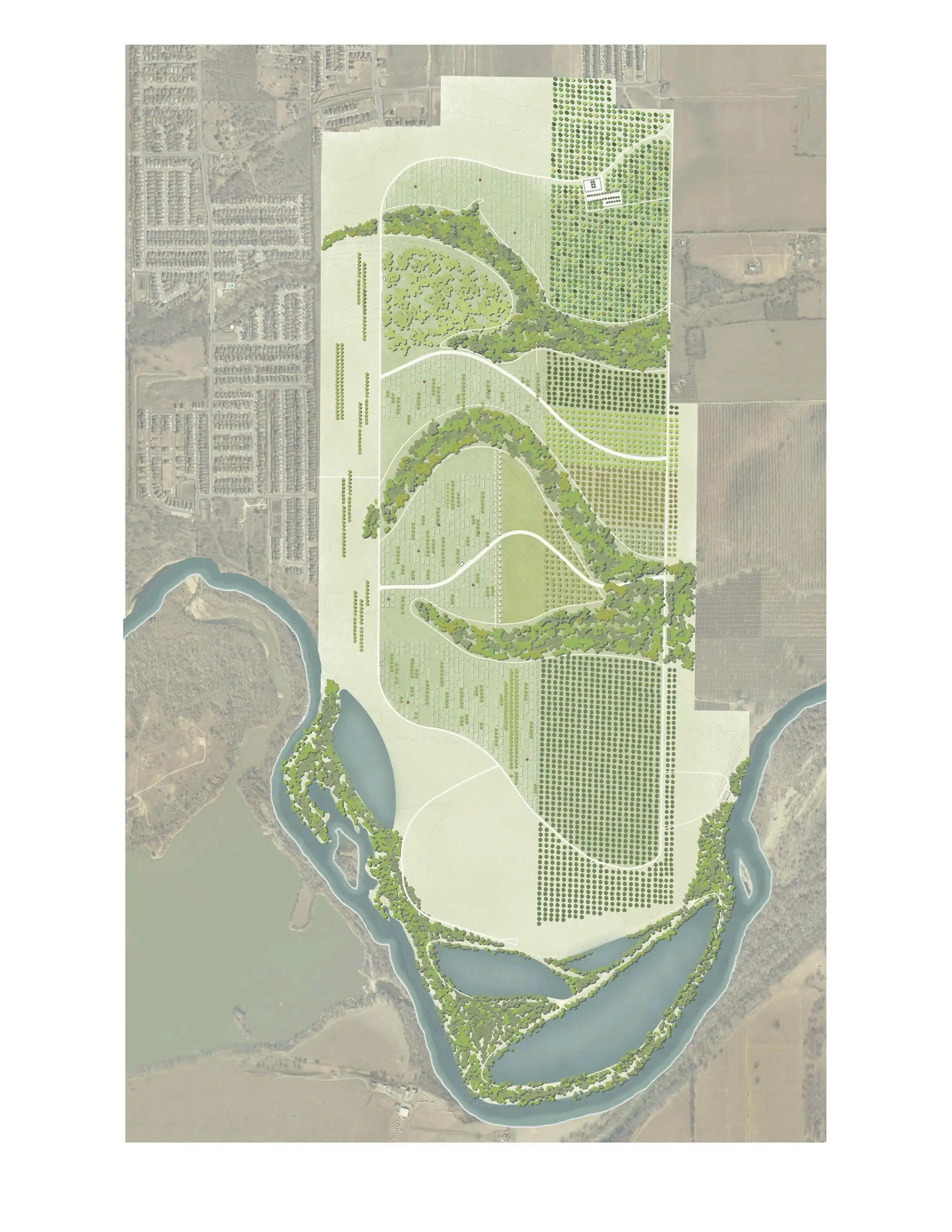
This proposal for a 990-acre cemetery just east of Austin, Texas draws parallels between the human cycle of life and death and the geological cycle of sedimentation and erosion. The site is shaped by fluvial processes, resulting in two major swales which organize the zones of disposition, each formed as a cut in the earth. The detailing of the burial plots themselves highlight the act of sedimentation and the continual change that occurs over time.
-
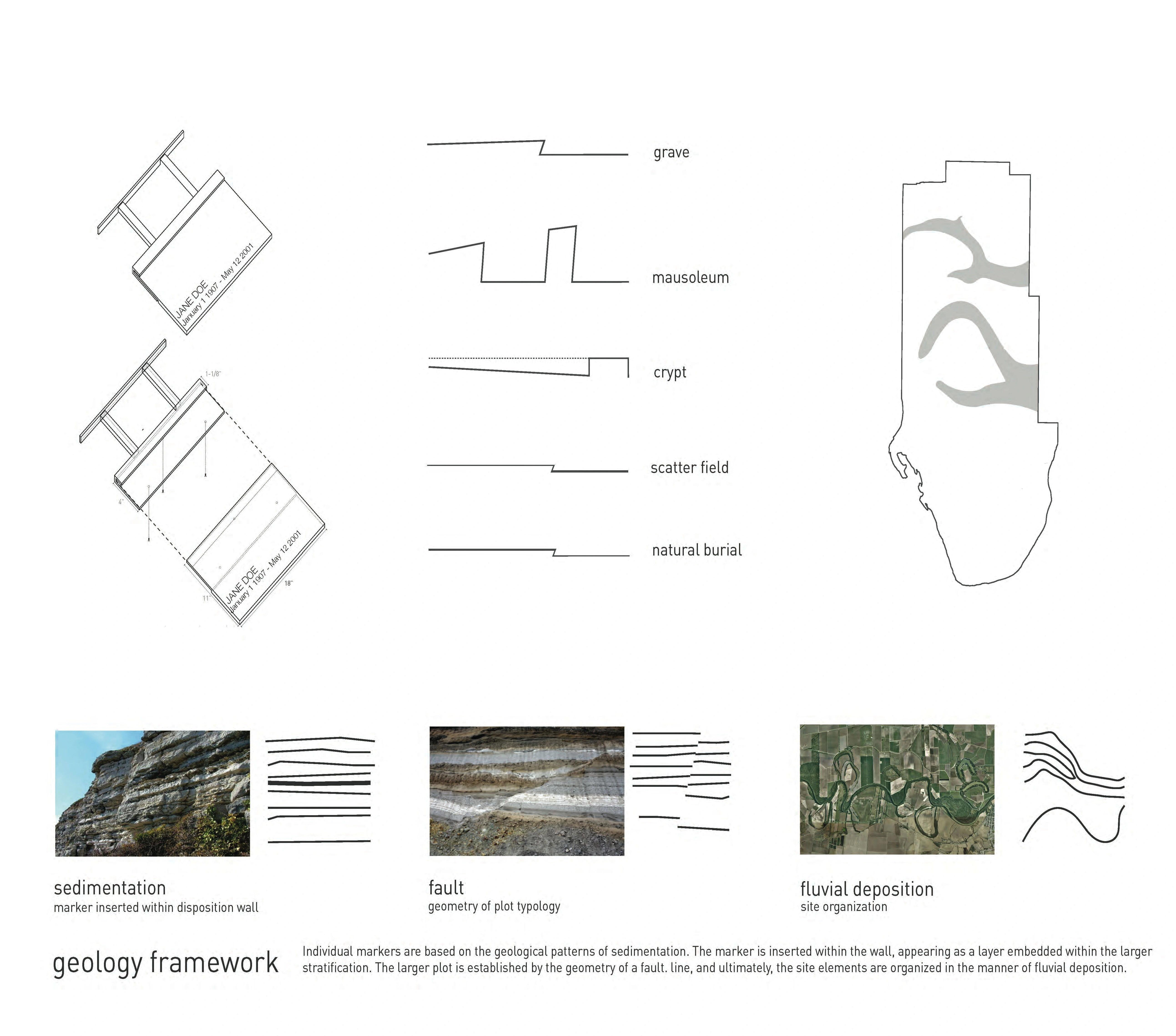
A cemetery is a place where the connection between body and ground can be directly experienced. The very concept of ashes to ashes, and dust to dust applies not only to the body, but to the earth itself: the geological cycle is defined by the constant creation and destruction of stone, through sedimentation and erosion. This cemetery highlights the act of bodily disposition as an act of cultural sedimentation. In order to create grounds for the dead, we used ideas of geological processes to form the ground in response to disposition. We employed three different types of geological processes for three different scales of the project. The markers are reminiscent of sedimentation, the laying down and cementation of soil over time. The plots are reminiscent of faulting or uplifting, a sudden shift in the earth at a specific moment in time. And the organization of the site is reminiscent of fluvial processes, the cyclical depositing, eroding and shifting of riverbeds over time.
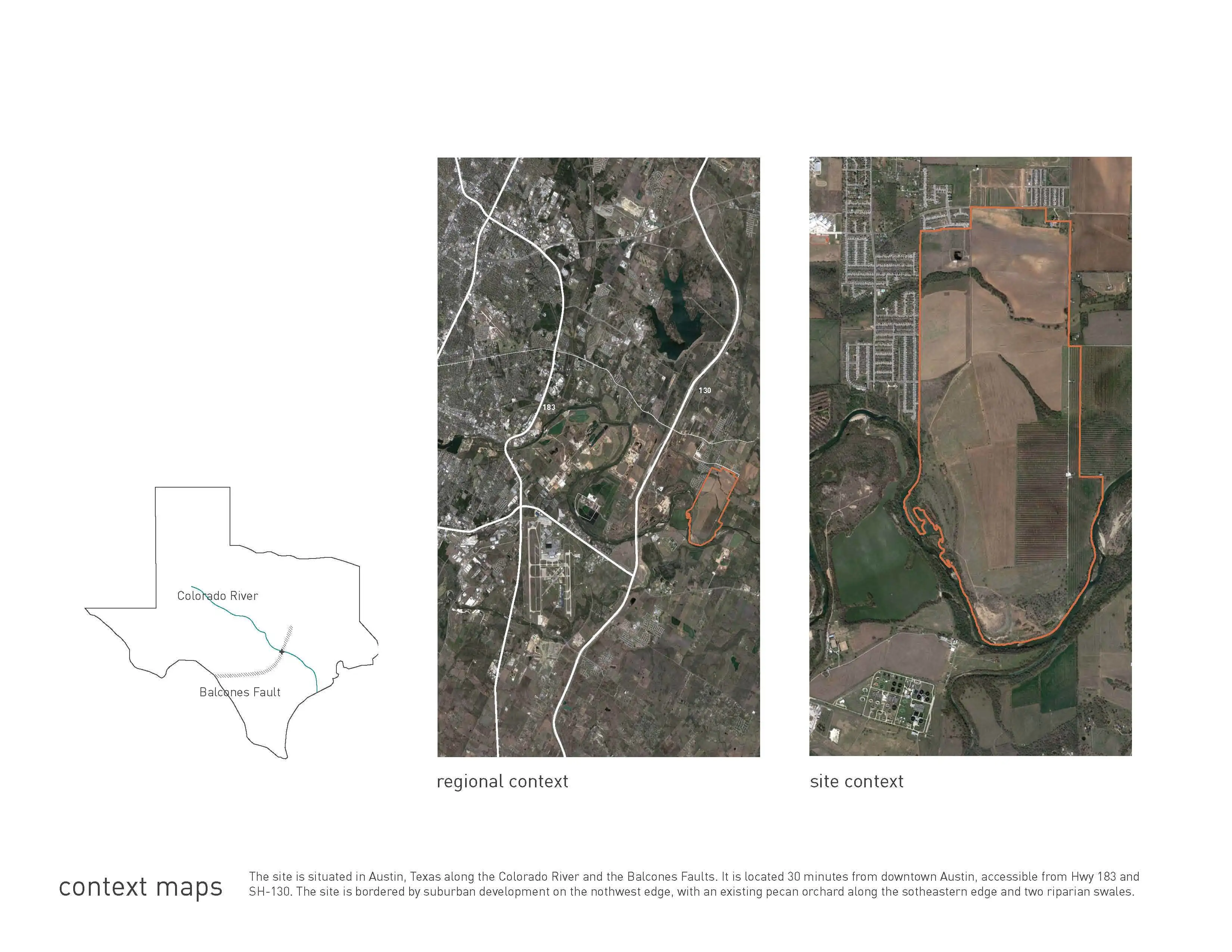
The 990-acre site for the cemetery is located east of Austin, Texas, about 30 minutes from downtown. Sitting along the Colorado river and just east of the Balcones fault zone, the site is bordered to the west and north by single-family housing and to the east by agricultural land. The southern end will be converted to a gravel quarry before the whole site becomes a cemetery.
Currently, the flat and expansive site is used for hay fields and pecan orchards. Two major vegetated swales cut through the site. This existing vegetation is the basis for the three main vegetation types in the proposal. Native prairie will replace many of the hay fields. Bottomland forest will follow the swales and riparian edge. Upland forest, including the existing pecan orchard and a proposed tree nursery, will occupy a band along the eastern edge of the site. The prairies consist primarily of native Texas blackland prairie grasses such as bluestems and muhlys while the turf pathways between disposition plots are planted with a native grass turf mix (including grasses such as buffalo and blue grama). The bottomland forests are planted with species such as bald cypress, cedar elm, and yaupon holly and the upland forest—the eastern strip of orchard, nursery, and forest—includes oaks, pecans, and cedar elms. The trees from the eastern strip are repeated within the area of disposition to provide shade and break up the extensive disposition zones. Although the swales are bounded by pedestrian paths, the paths occasionally become boardwalks allowing for the vegetation of the swale to extend into the prairie areas. Visitors will thus experience both the edge and the interior of the swale.
The proposed program at the site will include both constructed wetlands for recreation and habitat in the southern end of the site (where quarrying will have occurred) and a tree nursery in addition to the primary cemetery program. The cemetery itself will include one primary chapel and crematorium, three smaller chapels, and a reception platform. The cemetery will accommodate six distinct disposition types: in-ground burial, interment in a crypt, interment in a mausoleum, inurnment in a mausoleum, natural burial (in which a shrouded body is placed into a grave dug by family and friends), and ash scattering. These plots will be laid across the slightly undulating terrain.
For each of the disposition types, a concrete retaining wall will appear as a cut in the earth, making layers of sedimentation visible. The concrete will be poured with varying aggregates, cement types, and hydration in order to achieve a stratified appearance and to emphasize the idea of sedimentation. The markers themselves will be highly customizable bronze plates of varying size depending on the type of disposition. The marker plate slides into a poured-in-place-bracket in the wall and serves as a shelf for leaving mementos for the deceased. For those disposition types without individual plots—ash scattering and natural burial—no individual bronze markers are placed. Instead, the wall serves as a threshold to delineate the zones of disposition: a bigtooth maple forest for natural burial and a wildflower meadow for ash scattering. In the scatterfield, wildflower seeds can be scattered along with the ashes, thereby creating a loose, ephemeral marker in the area of scattering.
This proposal aims to give expression to the idea that both the cycle of life and death and the cycle of geological processes allow us to see the passage of time. The vegetation will change and escape the parameters we’ve defined, the ground will continue to shift and change, and the bodies of the deceased will return to the earth and define a new stratum in the physical or geological accumulation of time.
-
University of Texas at Austin
Hope Hasbrouck, Assistant Professor; Carmen Garufo, Assistant Professor; Matt Fajkus, Assistant ProfessorEddy Wylie Designs
Eddy Wylie, Principal
Advertisement
Related Awards
Award of Excellence, General Design
A Floating Forest: Fish Tail Park in Nanchang City
In Nanchang, within the Yangtze River floodplain, we revitalized a heavily degraded 126-acre landscape into a floating forest that manages stormwater, restores habitats, and provides diverse recreational spaces—all within a limited budget and a short timeline. This innovative urban nature model strengthens the district’s identity and spurs surrounding development. Fish Tail Park offers a scalable solution for flood-prone regions, seamlessly integrating flood resilience, ecological restoration