
.webp?language=en-US)


From Landscape Architecture to Art (and Back?): "Realities" of Nature, Layered Up
by Darren Sears
In my fifteen years of landscape architecture education and practice I always felt pulled in two directions. On one hand, I was excited by the rapidly-evolving, idea- and technology-driven side of the field emphasizing the interconnectivity of cultural and natural processes. But on the other hand, I was still drawn to engage nature in a form-focused way that treats it as static and distinct; it’s this passion that led me to landscape architecture in the first place, before I appreciated the field’s complexity and potential.
About seven years ago I began what I expected to be a one- or two-year break from the profession to give some undivided attention to that original passion, through artwork, despite knowing its limitations. I suppose I wanted to get it out of my system. That work wouldn’t have taken the form that it did without those intervening years of design, but I never expected that the two pursuits (and those two directions) would intermingle to the degree and depth that they have. The journey isn’t finished yet, but it’s shed some new light on how these seemingly contradictory attitudes toward nature might be visualized and reconciled. This post, drawing and building upon my 2023 publication in the International Journal of Cartography, will dive into that journey.
Part of what initially attracted me to landscape architecture was its emphasis on the “view from above” a site and simultaneously the immersive experience from within it. Together they satisfy what seems to be my compulsion to fully “know” a place—to “surround,” frame, and organize it while being surrounded by it, too. Both of those conditions can be created through physical engagement and intervention, or to some degree through representation alone. (The compulsion isn’t unique; something like it has driven imaging and manipulating the earth for centuries, as Denis Cosgrove has described.) This dual emphasis in the field has been tilting toward the latter, immersive side—toward the tactile and temporal and away from detached, controlling, and fixed—but it’s an un-balancing that I haven’t exactly embraced. I look for a sense of structure and control not just in the plan view but also in the on-site experience itself: ideally that experience is spatially “compressed” (and seemingly frozen in both time and space) in a way that makes the “view from above” perceptible on the ground. For me, contingency and indeterminacy can be exciting and inspiring, but so can the guardrails we try to place around them.
Even further resisting this turn toward the interactive and process-oriented, my compulsion for ordering is especially strong for natural environments, where I mean “natural” in a relative, superficial sense. (The real complexity of that term, though, does end up playing a central role in where all of this leads.) For me, the origin of these environments outside of human intentionality makes their ability to engage and enchant us all the more significant in general. But when they have a particularly “structured” aspect—distinct external or internal “frames,” related to Joan Nassauer’s idea of “orderly frames” (1995) but with a different kind of effect—they seem to generate a uniquely potent form of that knowability. The structuring can itself be the result of human manipulation, again physical and/or graphical. But ideally it exists “naturally”—in the form of sharp edges and contrasts creating islands and archipelagos, slicing or compressing the natural world into more comprehensible pieces. I think of mountains with complex vegetational zonation patterns, incorporating rare species and ecosystems, as the best example of this. They’re like miniature continents, eliciting a kind of “world at your fingertips” sensation.
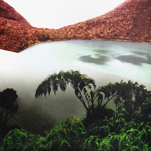
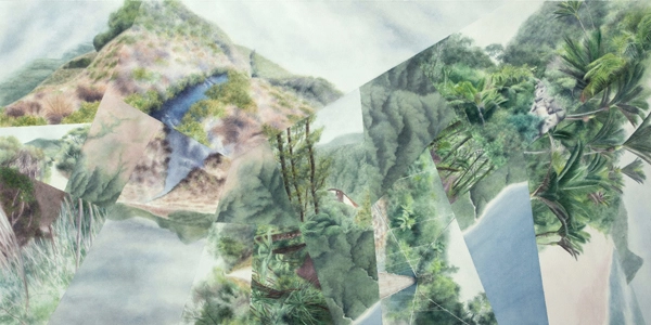
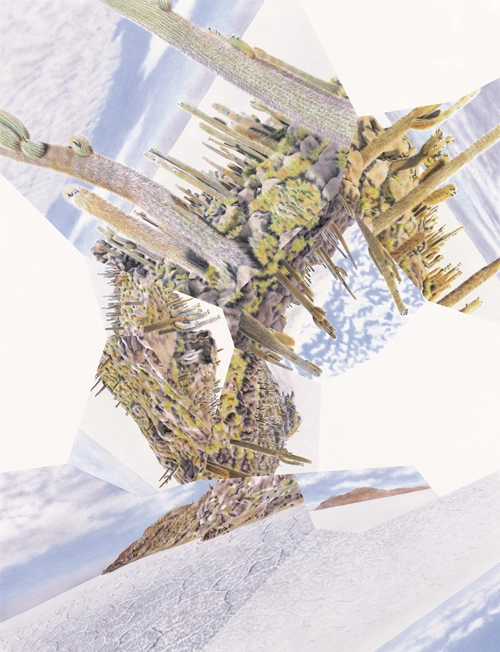
The urge to add definition to natural places—or, especially, accentuate definition that’s already there—has an artistic, “modernist” element that paradoxically landed me in design offices that focus mainly on urban sites. I assumed I’d find a way of resolving that issue. But in the meantime, early in my career I set out to satisfy the urge in my own time by montaging pieces of travel photos to invent impossibly sharp precipitation gradients and to maroon plant populations on precariously tiny islands. The goal was to emphasize the edges of each view fragment and the contrasting views beyond it rather than the individual fragments themselves. That translates to a sense of traveling through and at the same time floating above the geography as a whole—or experiencing the plan view at ground level, as I put it earlier. These photomontages evolved into oil paintings and eventually (around the time I decided to leave design practice) into watercolors.
The focus of the watercolors gradually shifted from geographical fantasies to idealizations of real locations that I could explore and document in depth. To date they cover ten countries on six continents, weighted toward South America and Oceania. Edges and contrasts are still the theme, but the components in each composition have multiplied in number (and they’ve started to incorporate aerial views, too), breaking down the contrasts into finer gradations. The works have taken on a cubist, mosaic-like quality. Evolving them in yet another direction, I’ve also expanded the subject matter to include nature structured and sliced up by human intervention: remnants of native ecology surrounded by urbanization or cultivation.
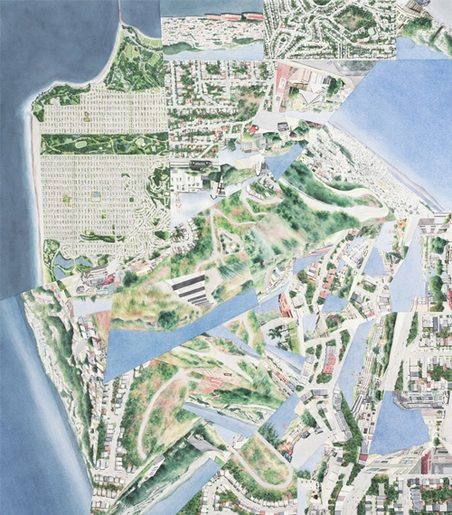
Since the emphasis of all these works is on the spatial relationships between the different facets, I think of them as immersive maps (or, more descriptively, as “worldviews”—compressing entire, multidimensional “worlds”). Particularly as the compositions have become more intricate and incorporated the aerial components, becoming more straightforwardly cartographic as a result, “painting” feels secondary to map “design” in terms of both the process and the product.
This article will continue here on The Field next week—stay tuned for more on how this artistic exploration of immersive mapping has evolved to engage multiple perspectives on ecological stability and change.
References
Corner, J. (1999). The Agency of Mapping: Speculation, Critique and Invention. In Denis Cosgrove (Ed.), Mappings (pp. 213–252). Reaktion Books.
Cosgrove, D. (2008). Geography and Vision: Seeing, Imagining and Representing the World. I.B. Tauris & Co. Ltd.
Getch Clarke, H. A. (2005). Land-scopic Regimes: Exploring Perspectival Representation Beyond the “Pictorial” Project. Landscape Journal, 24(1–05), 50–68.
Nassauer, J. I. (1995). Messy ecosystems, orderly frames. Landscape Journal, 14(2), 16-170.
Sears, D. (2023). Fracturing & Fluidity, Isolation & (Dis)Integration: Mapping Ecological Islands & Edges in Painting & Music. International Journal of Cartography, 1-22.
Darren Sears is an artist-cartographer based in San Francisco. He received his MLA from Harvard’s Graduate School of Design and BA from Stanford, and has practiced design with Terrain Studio, SWA Group, and Martha Schwartz Partners. Darren is represented by HANG ART Gallery in San Francisco, and further explores the themes of his visual work through journal articles, musical composition, and regular talks at cartography and geography conferences.