.webp?language=en-US)


The Digital & The Wild: Mitigating Wildfire Risk Through Landscape Adaptations
Jordan Duke, Student ASLA

The project showed a quality of planning and analysis that could be replicated in other contexts. A remarkable project!
Awards Jury
-
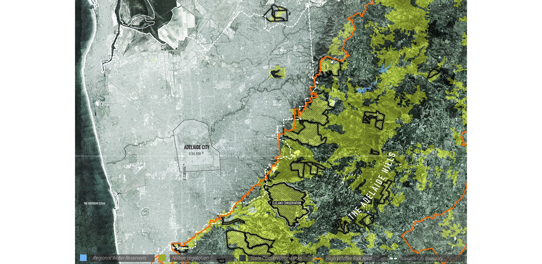
Fire plays a critical role in the ecological processes of the Australian landscape. But when wildfires become uncontrollable, human lives and infrastructure are put at risk. Rising temperatures and fewer rainfall days resulting from climate change is extending the wildfire season, making wildfires even more difficult to contain. Using Cleland Conservation Park in South Australia as a testing ground, this thesis hypothesizes mitigating wildfire risk through digital environmental monitoring sensors paired with short and long term landscape adaptation strategies.
An ongoing feedback loop of data compresses our reaction time to outbreaks from reactionary to preemptive. On a longer timescale, data processing can adapt landscapes by tweaking ecological processes on site to generate fire breaks, windbreaks and reduce fuel loads. These didactic devices employed across the site register environmental phenomena previously invisible to the eye, triggering human behaviour changes while generating new approaches to fire management and a new park typology. By establishing frameworks of negotiation with ecology – not controls – the thesis contemplates our evolving relationship between nature and the digital world. -
Landscape Architecture & Wildfire Risk
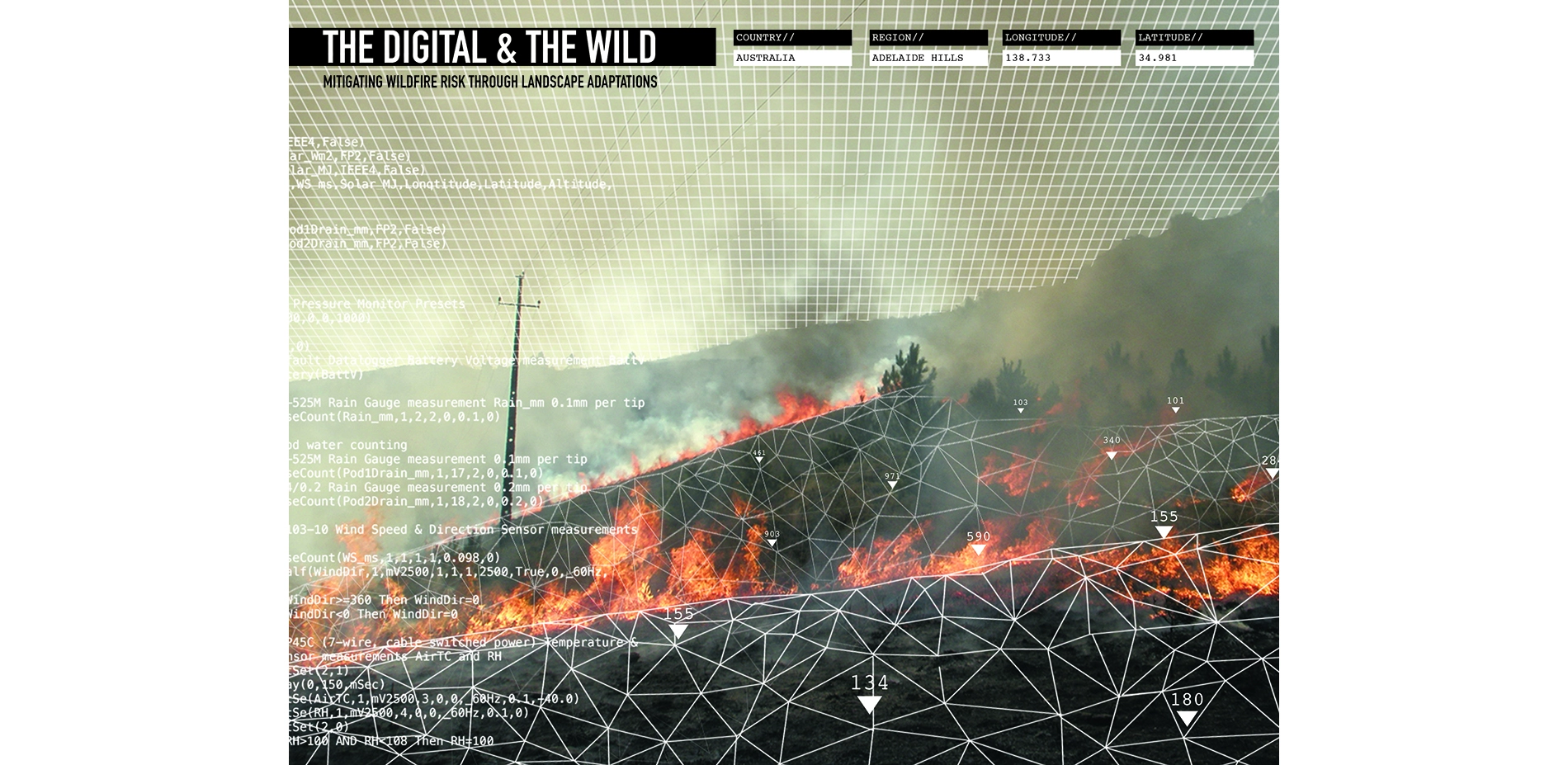
On January 5th 2015, on the outskirts of Adelaide, Australia, huge plumes of smoke rose from the horizon as thousands of hectares blazed. The red orange glow in the night sky was a persistent reminder of the wildfire’s power. The Sampson Flat fires in the Adelaide Hills were preceded by the 2014/2015 summer season, one of the hottest on record with one of the lowest rainfalls. Despite our best efforts to predict and manage them, devastatingly large wildfires still occur and as such, fires have become more frequent, intense and difficult to contain than ever.
As a discipline that precipitates change and adaptation, landscape architecture can provide a new alternative to fire management in an uncertain and changing climate. Furthermore, with modifications, the thesis is adaptable to other fire prone landscapes like California or Fort McMurray. Rejecting the traditional conservationist approach to park management, the project aims to blend the boundaries between nature and technology and establish a new understanding. The thesis allows landscape architecture to be the negotiator of a multi-disciplinary approach to address wildfires - and ultimately - climate change.
Fire Management Today: Reactive vs Preemptive
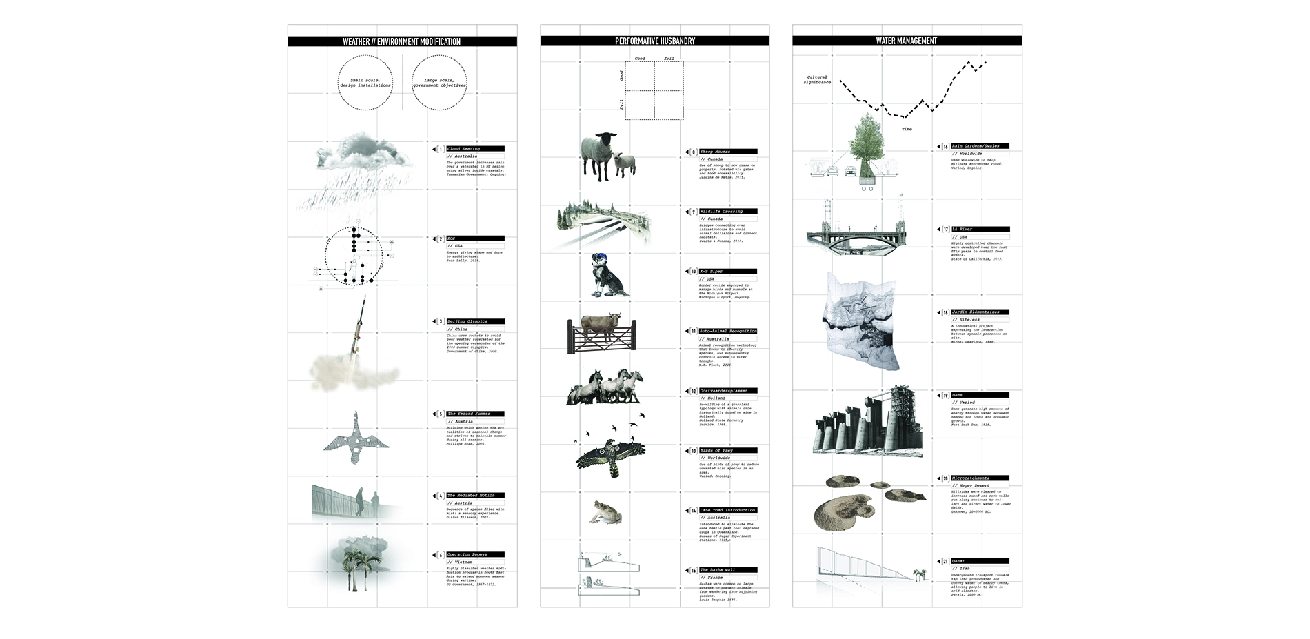
Today, a portfolio of fire management techniques exists which include remote sensing, drones, GIS mapping, volunteers and trained firefighters, community bushplans, firebreaks (the removal of vegetation for emergency access and fuel breaks) and prescribed burnings (burning forest patches during cool seasons). While many of these techniques track and evaluate an area’s likelihood of burning, only a select few reduce the risk of a large wildfire occurring in the first place. Landscape architecture has tools to increase the number of preemptive strategies available to fire services to reduce risk, as well as create places of cultural and ecological value.
Timescales & The Agency of Landscape Architecture
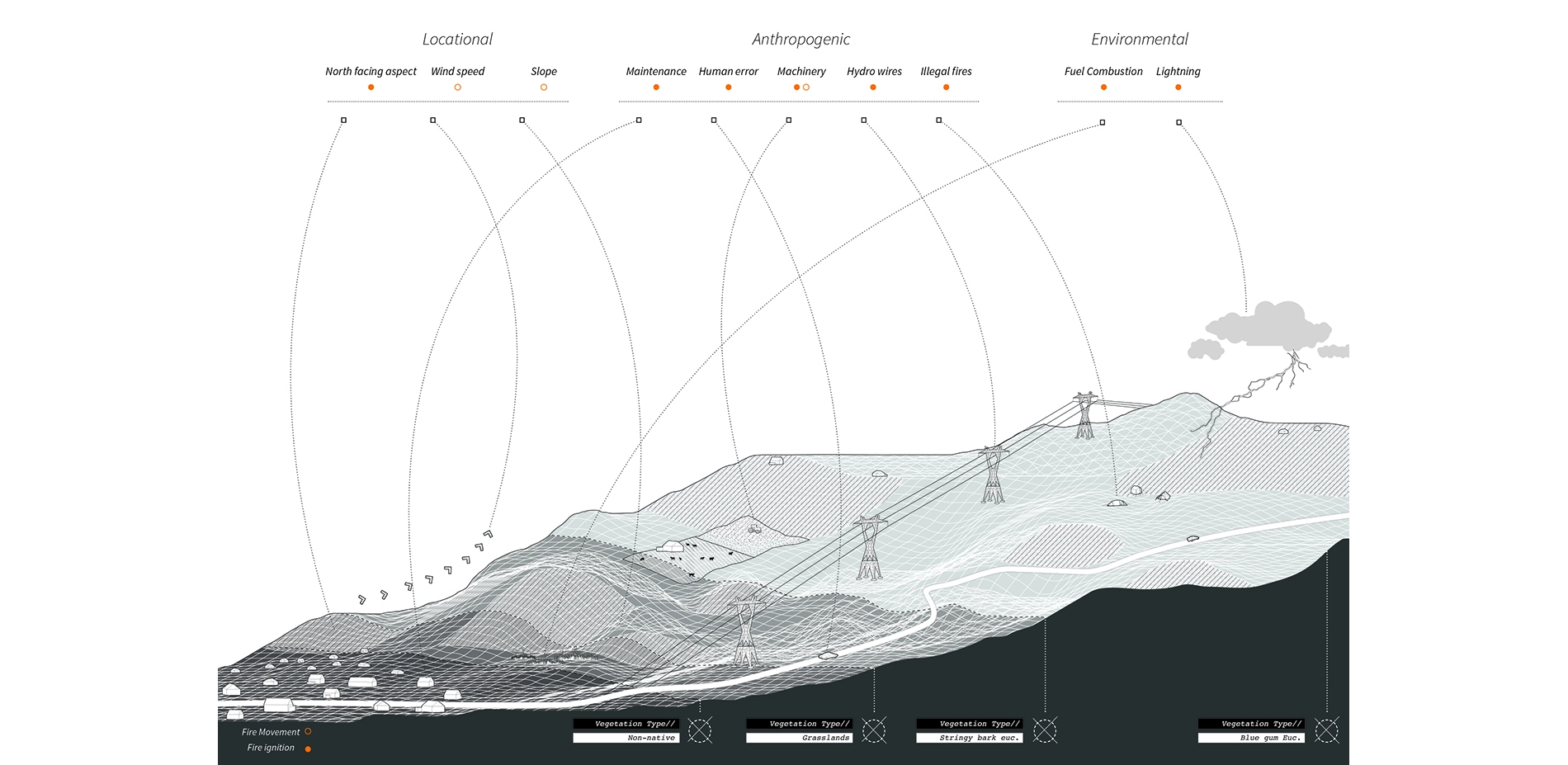
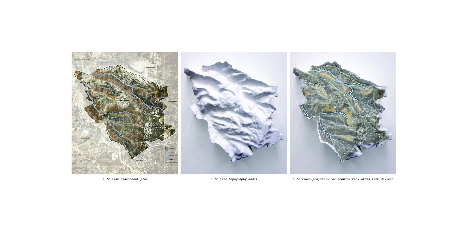
Using the landscape itself to derive risk mitigation strategies, documentation of the on-site operational elements were identified. Specific elements found on site are changeable, within the agency of landscape architecture and an alterable timescale of a human.
Documented elements include: climate and weather, human infrastructure; flora and fauna; water; topography; and soils. It is through the adaptation of select on-site elements - climate, weather, water and flora/fauna - that highly specified devices were designed to mitigate wildfire risk.
Timescales & Sensor Technology
In thinking about timescales, strategies were developed to address two time scales: the short and the long-term. As sensors become cheaper and easier to deploy, it allows for real time monitoring of fire variables that are known to indicate the likelihood of a wildfire. These variables include (but are not limited to) things such as slope, water availability, humidity levels, wind direction, temperature, vegetation densities, fuel loads and vegetation types.
Using sensors to track these variables we produce an ongoing feedback loop of data; real time sensors allow us to shorten our response time from reactionary to preventative when critical levels are hit. Responding to inputs of data, short-term these devices can immediately activate water redistribution, increase humidity levels and soil moisture levels.
Long-term, these devices trigger landscape adaptations. Trees becomes windbreaks, eroded valleys open up firebreaks in the forest, and fuel management is conducted by shepherding fauna around the site. By engaging with existing vectors on-site like hydrological channels, wind patterns and animal movement corridors, the landscape architect curates ecological processes to achieve desired landscape outcomes.
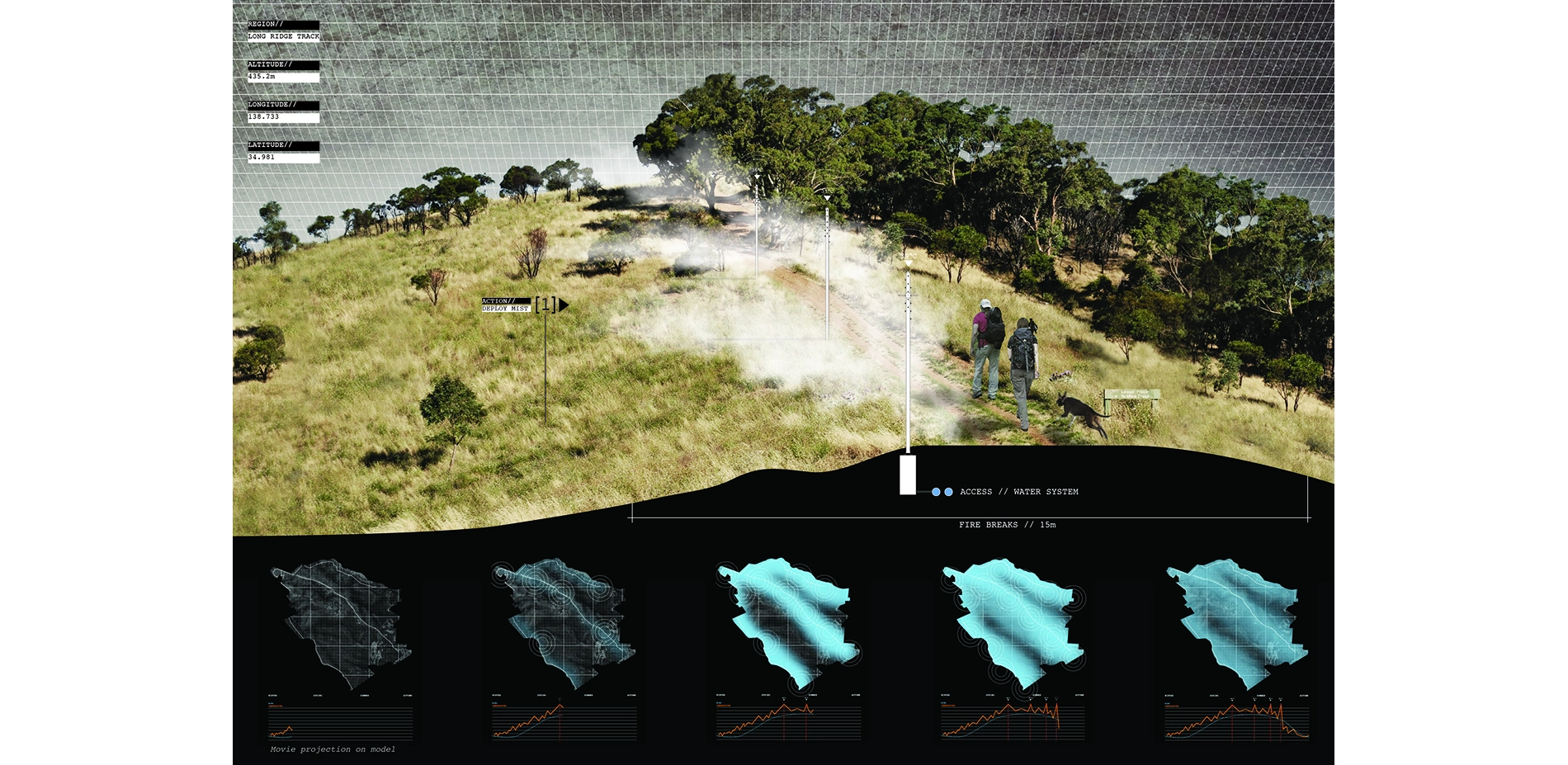
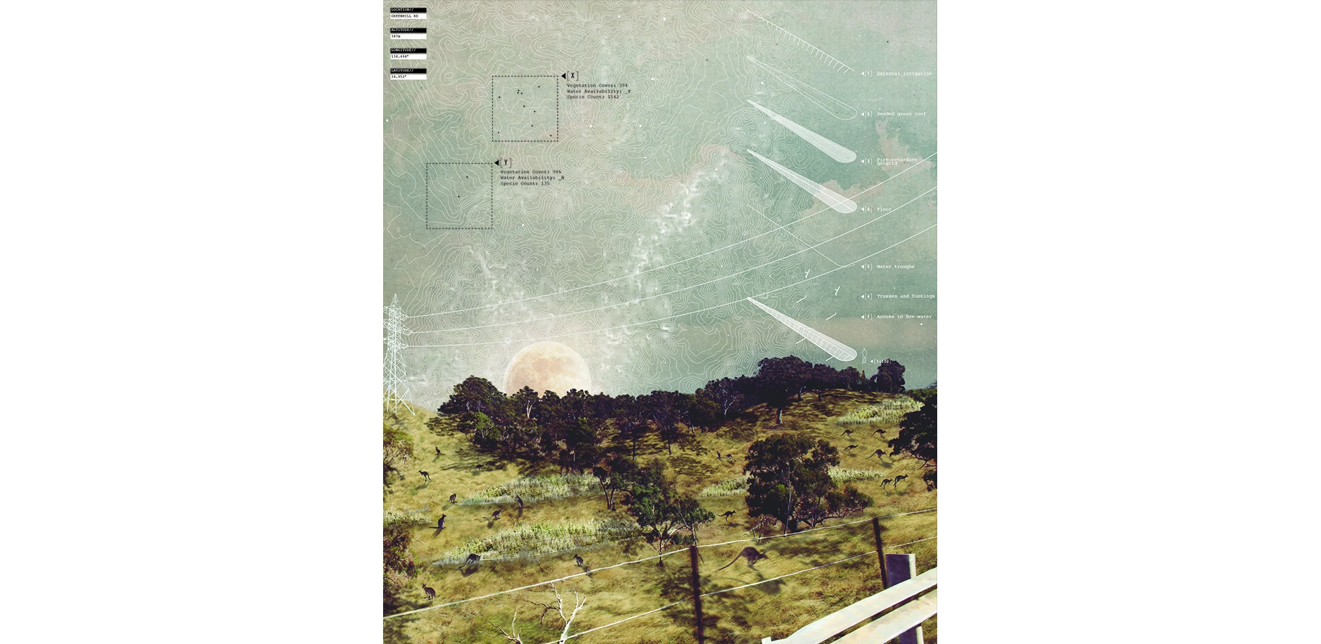
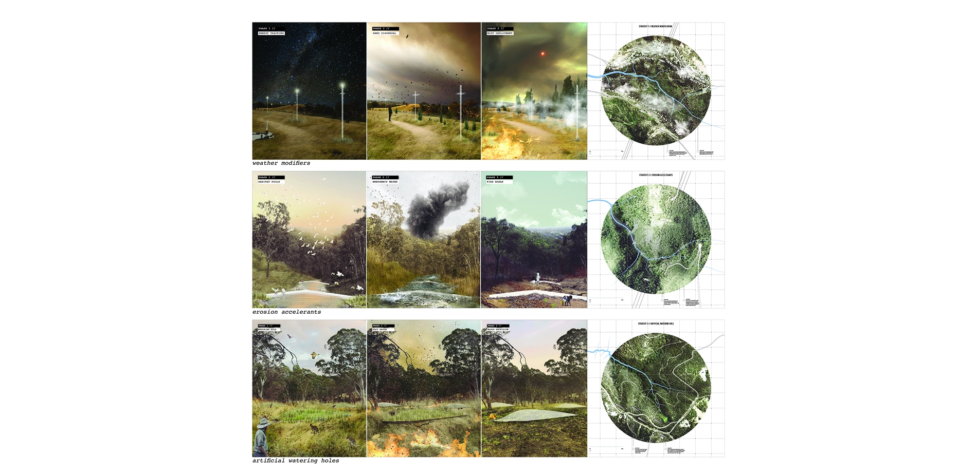
Device 1: Weather Modifiers
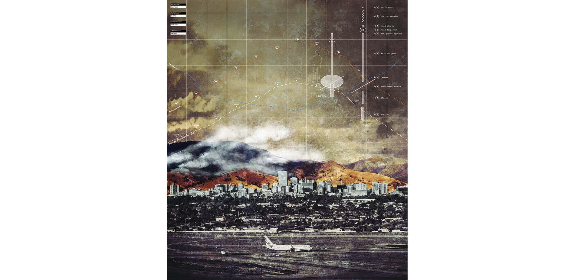
Weather modifiers are placed as a continuous datum along ridges and valleys, taking advantage of the continuous south-west sea breeze arriving off the Southern Ocean. When temperatures hit 35 degrees Celsius, the weather modifiers respond by dispersing mist, increasing the humidity levels. As the sea breeze reaches the devices, the cooler, wet air is spread across the site. On windy days, the device disperses Mediterranean cypress seed via a rotating mechanism. Along these ridges, these fire-resistant cypress trees grow into an allée, becoming windbreaks which slow the pace of fire and trap flyaway embers.
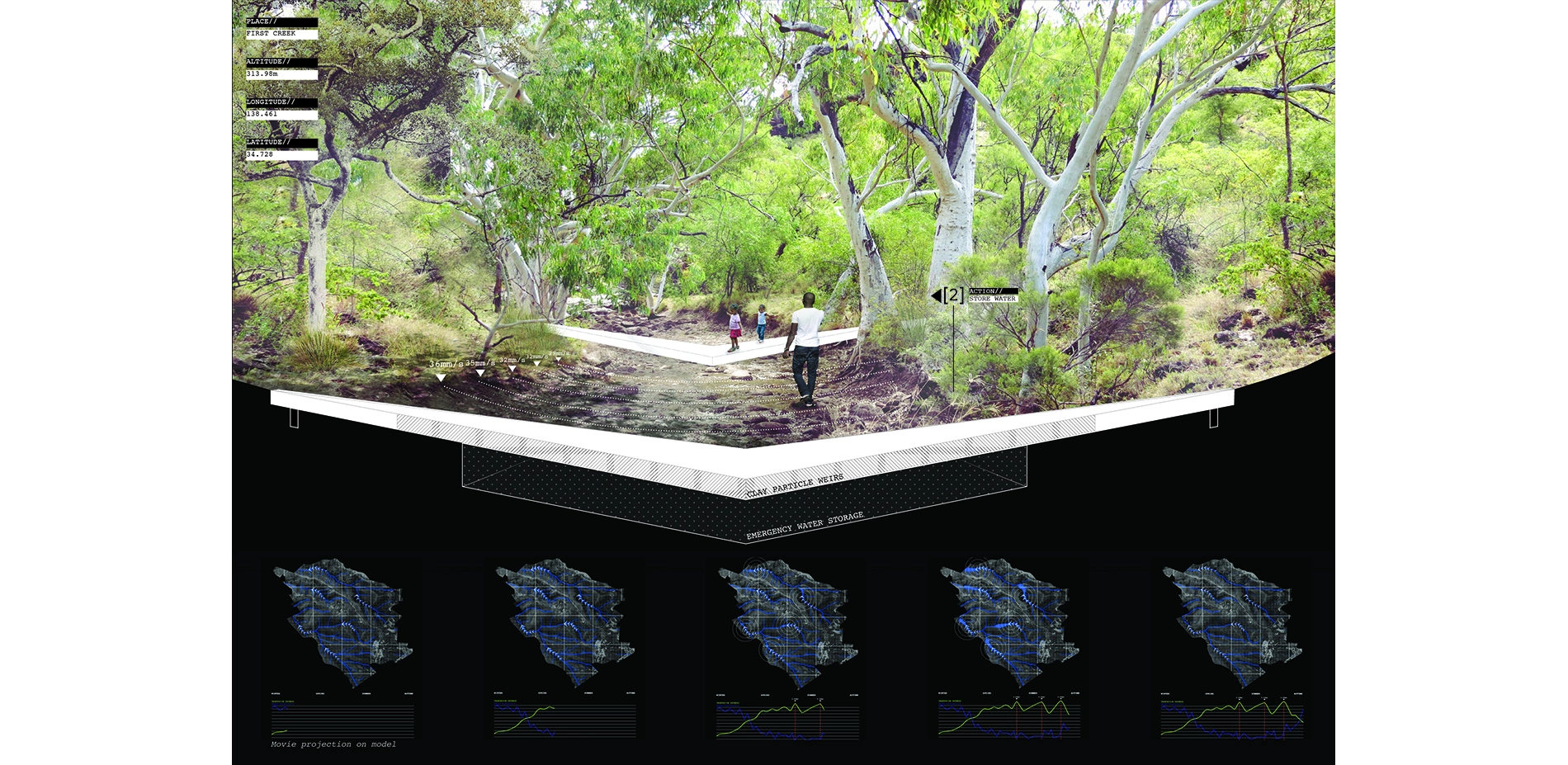
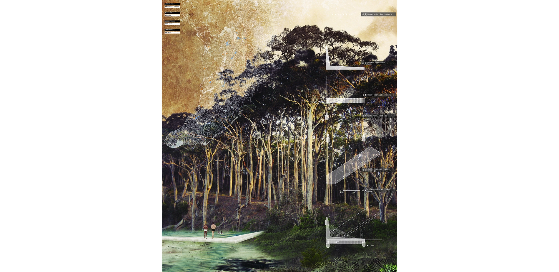
Device 2: Erosion Accelerants
The erosion accelerant devices are placed along the valleys of the site, capturing the increased rainfall during large storm events and the heavy, winter rains. Nine months of the year, the water is exposed as pools for swimming and wildlife refuges areas. During times of increased water availability, water is stored beneath for emergency fire events. When sensors indicate a wildfire on-site, the stored water releases into the valley below, eroding away vegetation with its enormous velocity. Long-term, weirs located beneath the device filter loam and sand, allowing only clay particles to pass through. With time downstream soil becomes less conducive to vegetation, effectively widening the valley by creating firebreaks in the vegetation and allowing for emergency access to firefighters.
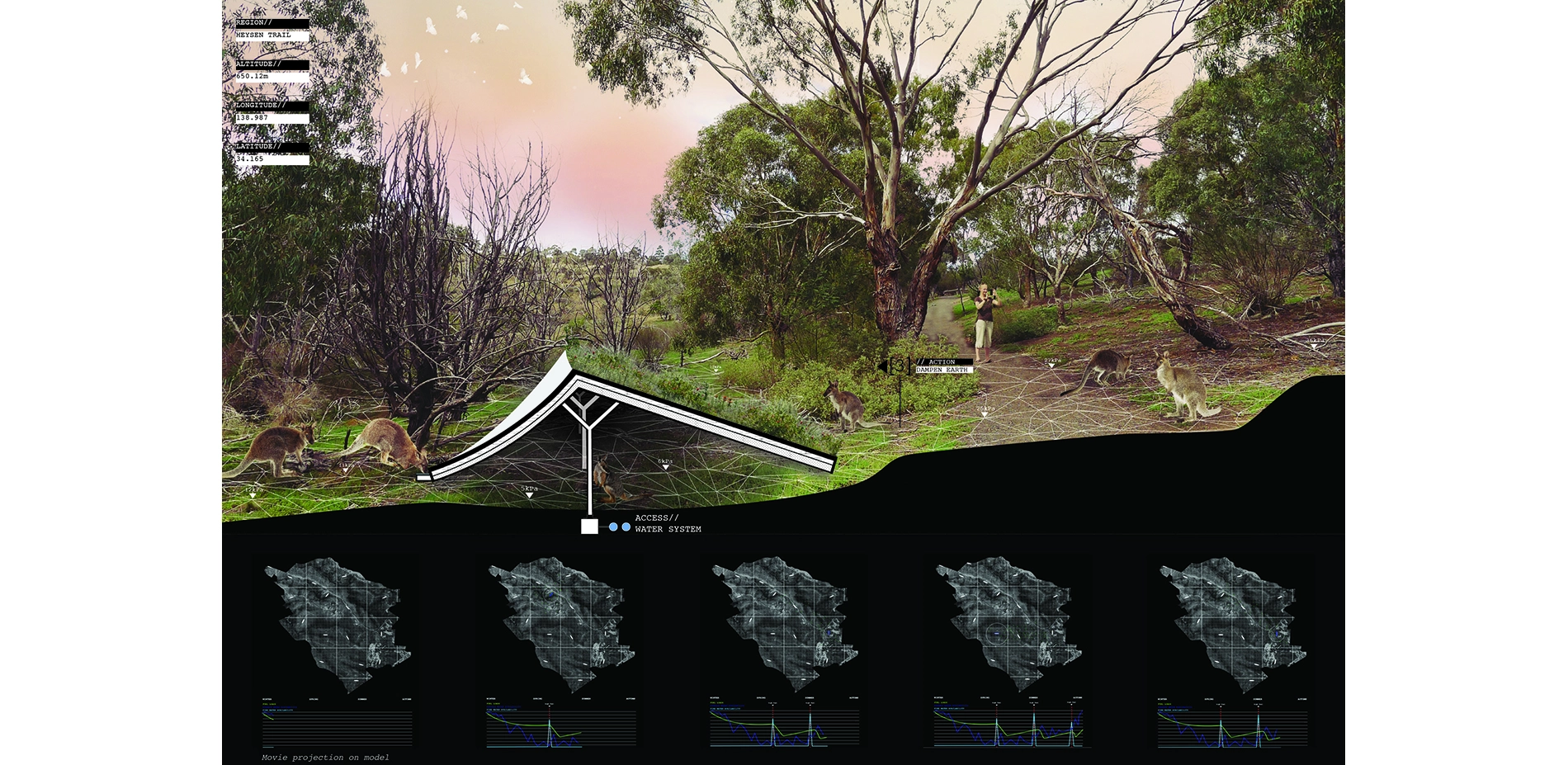
Device 3: Artificial Watering holes
The artificial watering holes are placed along open tracks in which animals frequently move through, such a foot paths and roads. These structures produce fresh green vegetation and a watering trough - both which attract native wallabies and kangaroos. The devices have their water supply wirelessly switched on and off, like rotating taps. The scarcity of water on site at certain times of year triggers a migration of animals to the area, who through the feeding of nearby vegetation, bring down fuel loads. During fire events, animals seek out cool and dark areas to hide, and these devices double as a refuge for animals before and after catastrophic fires.
Modifying Human Behaviour
Beyond acting as short and long-term risk mitigation strategies, the devices are didactic. Highlighting invisible phenomena and patterns normally imperceptible - but unquestionably contributing to climate change and subsequently wildfires - the devices attempt to modify human behaviour that contributes to climate variability.
At night, the weather modifiers among the hills are visible from the city, their intensities indicate the energy usage of the citizens of Adelaide. Registering from far away, it visualizes energy consumption to the city below. Highlighting periods of water availability in the regional water reservoirs, the number of pools activated within the erosion accelerants signal to users times of water scarcity. Finally, artificial watering holes are placed in highly visible areas to roadways and paths. The abundance of the green grass among the arid landscape and the surreal number of wallabies indicates an area high in fuel loads, and that care must be taken to avoid accidental ignition. The immediate visualization of energy, water scarcity and fuel loads brings immediate awareness to people and their daily actions.
Landscape Architecture As The Negotiator
The deployment of cheap sensors provides us opportunities to understand the landscape through many timescales, and quicken our response time to fire events. Long-term, these devices generate landscape adaptations like wind breaks, firebreaks and reduced fuel loads.
However, more fundamentally these technologies and devices become ingrained in the collective memory and cultural understanding of a place. They allow invisible and imperceptible phenomena contributing to climate change become highly conspicuous. In real time, they modify human behaviour and engenders a new type of sustainability that is behavioral based. Our daily actions have a direct link to larger, global scale issues, and as such, we can begin to make changes in our lives to tackle this global problem. Through landscape architecture, the collective conscious of a population is altered - and as such - real behavioral change occurs.
Advertisement
Related Awards
Award of Excellence, General Design
A Floating Forest: Fish Tail Park in Nanchang City
In Nanchang, within the Yangtze River floodplain, we revitalized a heavily degraded 126-acre landscape into a floating forest that manages stormwater, restores habitats, and provides diverse recreational spaces—all within a limited budget and a short timeline. This innovative urban nature model strengthens the district’s identity and spurs surrounding development. Fish Tail Park offers a scalable solution for flood-prone regions, seamlessly integrating flood resilience, ecological restoration