
.webp?language=en-US)


Sifting the Landscape: Transforming Vacant Lands through Smart Decline
Yuxian Li, Student ASLA
A fabulous set of tools to manage expectations for those in leadership positions to engage neighborhoods and communities. Modest and implemental, this project was smart and sensitive to the situation. Having access to these tools would make me as a leader sleep better at night.
Awards Jury
-
Many cities are currently facing severe shrinkage globally, resulting in increased vacant urban land and structural abandonment. As such, massively depopulating urban areas are now seeking ways in which to more intelligently manage deteriorating neighborhoods while strategically locating development in growing areas. This project aims to develop a design framework for Smart Decline through reclaiming and repurposing vacant lots. The approach emphasizes the implementation of development in dense nodes and temporary or green functions outside of these nodes to be managed and allow the city right size itself. A GIS based development suitability model was used to identify pockets of future nodal development while the Land Transformation Model was used to predict future sites of high probability decline. Then, a process of regenerating the vacant/abandoned lots called “Sifting the Landscape," was developed and applied prior to design program decision making.
-
Background
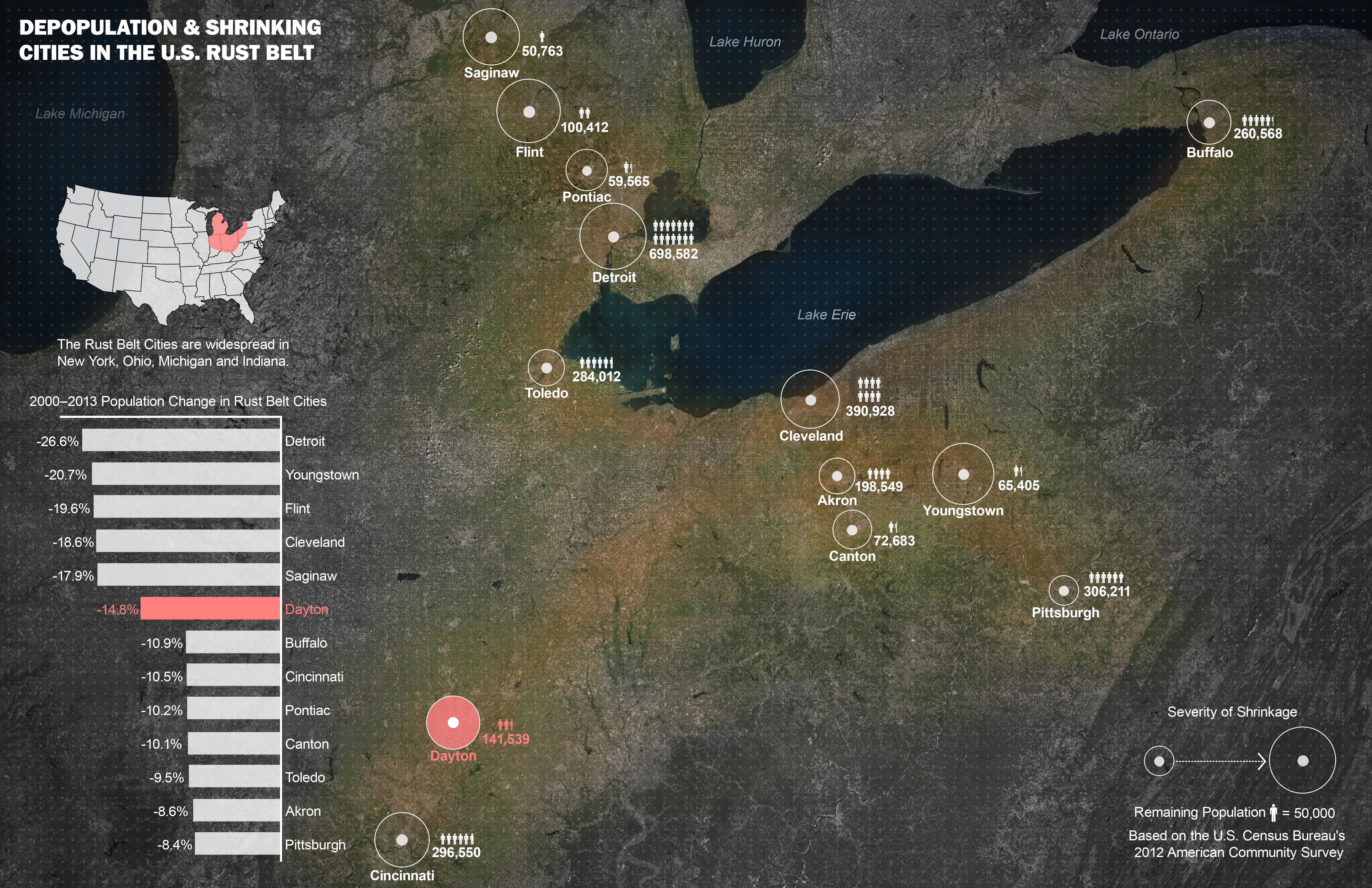
Between 2011 and 2050, the world’s population will increase by 2.3 billion and urban populations are expected to double. Despite urban population increases, many areas have also undergone large population losses. These cities are labeled as ‘shrinking,’ or massively depopulating cities facing extreme population losses. Over the last 50 years, 370 large cities globally have experienced shrinkage. As of 2012, 144 cities were shrinking, one quarter located in the U.S. Shrinkage has been reported to be a predominant causal factor for increased vacant urban land and structural abandonment.
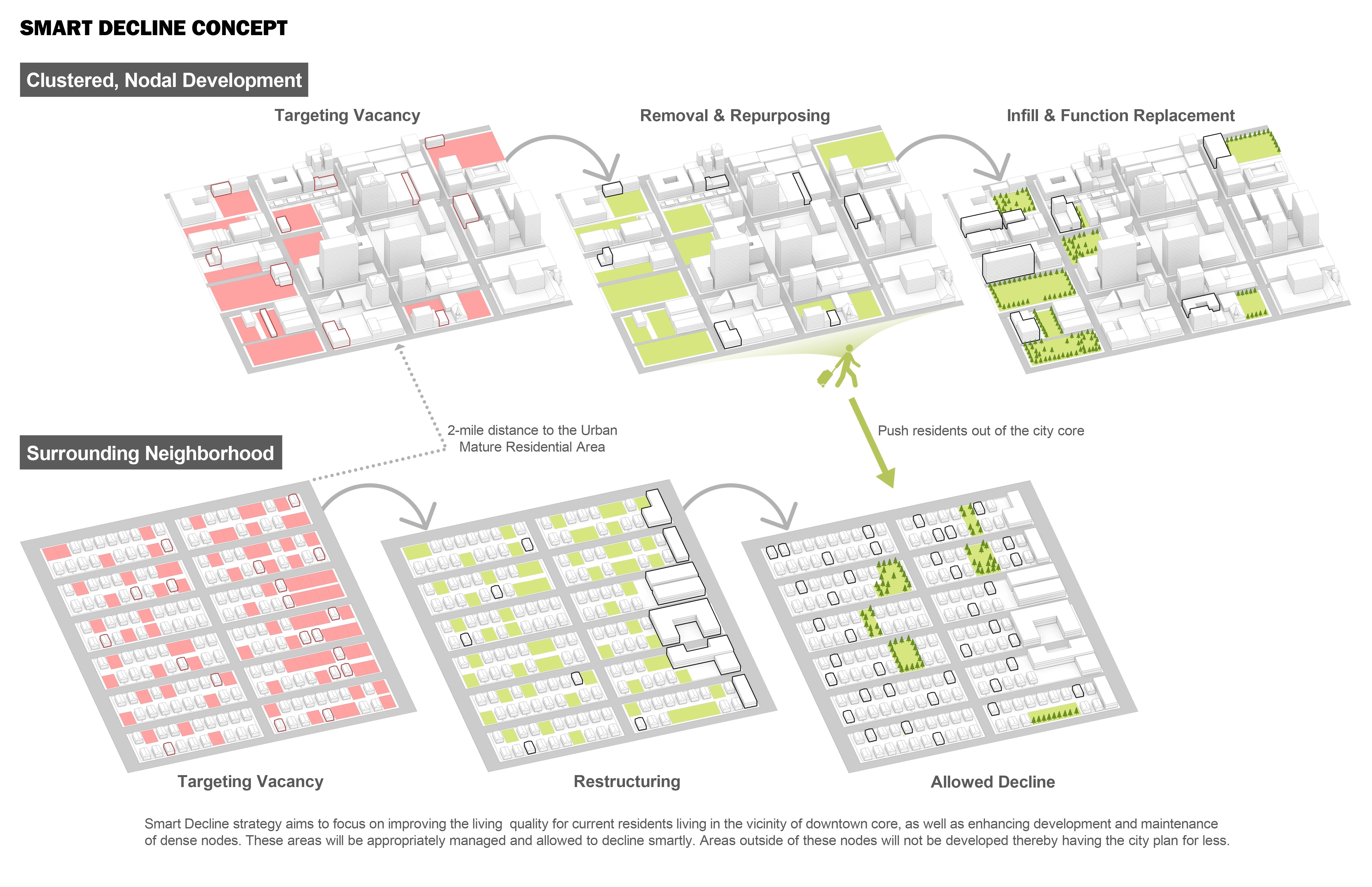
The inability to retain viable developments in shrinking cities has necessitated a shift from traditional urban growth to the allowance of Smart Decline. This approach dictates that cities strategically develop in dense nodes where development potential exists while allowing parcels outside of these areas to simply be managed or decline. Rather than force new developments into decaying areas, the idea is to allow the city to right size itself. Smart Decline seeks to reclaim and repurpose vacant lots through implementing permanent or temporary functions where possible. It is the re-appropriation of unused urban space for common community needs.
Study Area
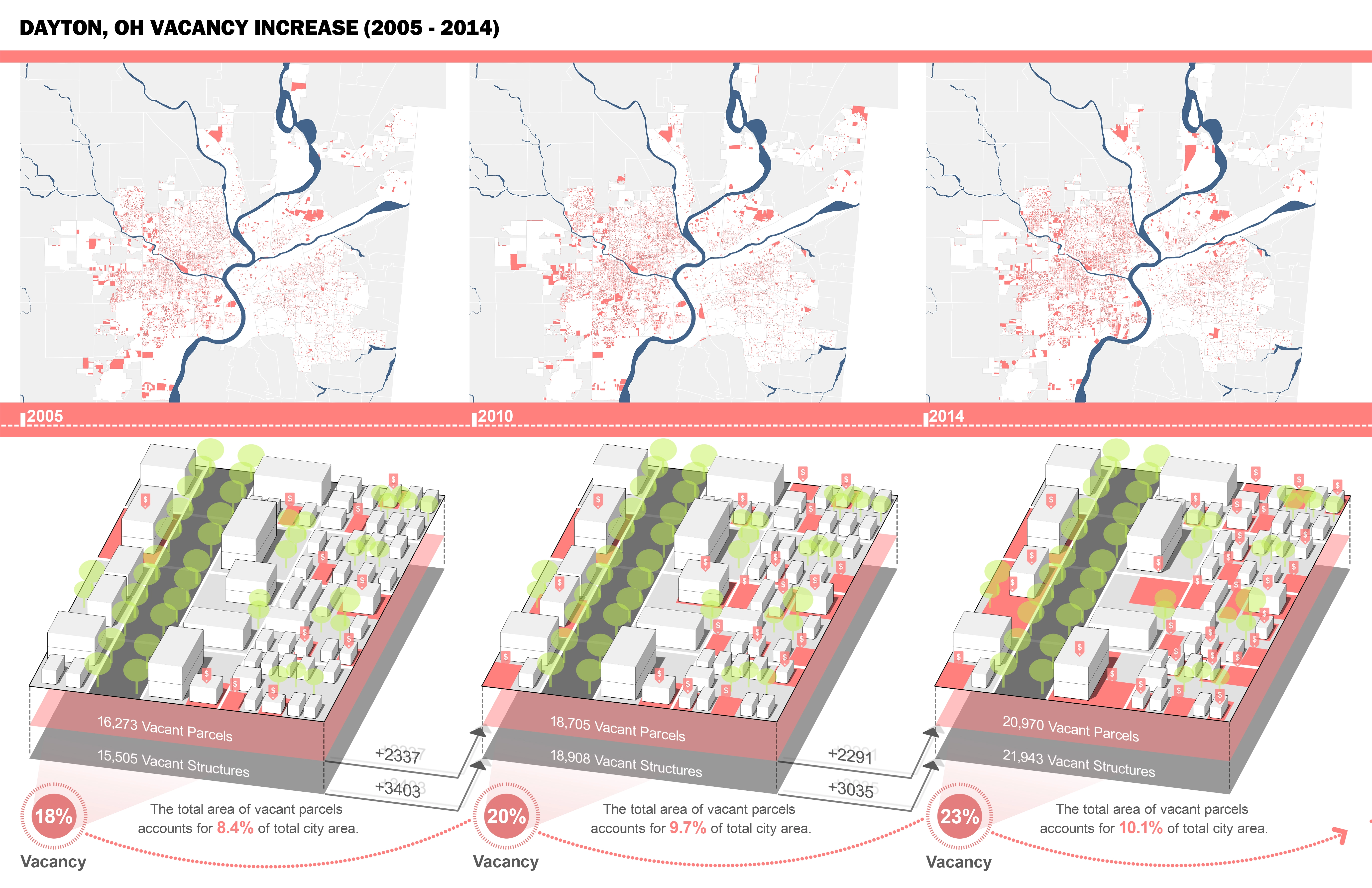
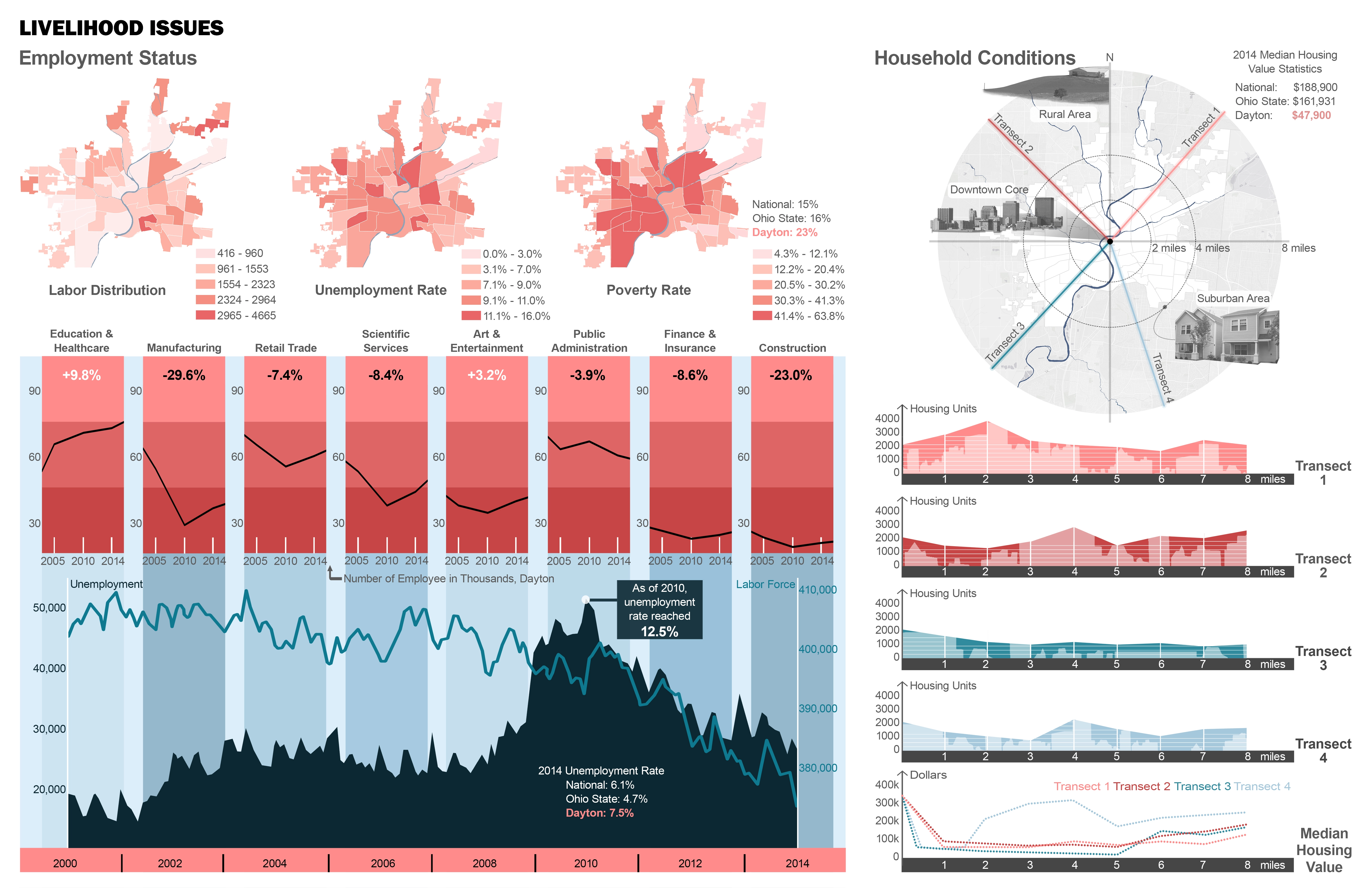
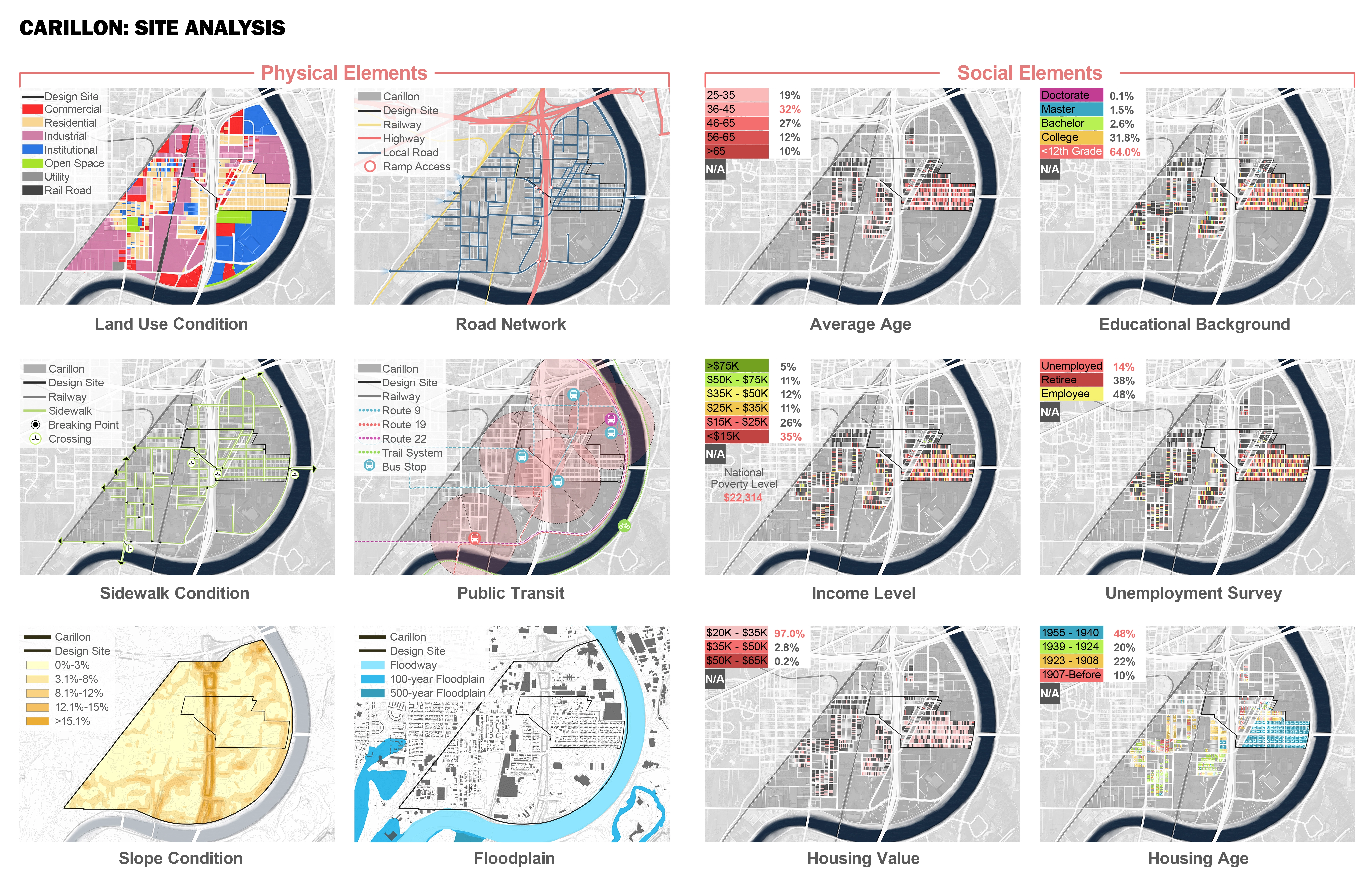
The collapse of the American housing market in 2008 amplified foreclosures and housing abandonment throughout many U.S. cities. Municipalities in the Rustbelt, a postindustrial region in the Northeastern and Midwestern U.S characterized by declining industries and falling populations, were hit particularly hard. Dayton, Ohio, a shrinking Rustbelt city, ranks in the top 10 in U.S. urban depopulation. From 1960-2010, its population decreased by 46%; over the last 10 years, unemployment has increased by nearly 170%. In the 1980s, manufacturing began to significantly decrease and by the 1990s, service and retail trade sectors began to employ more people than did manufacturing. A large proportion of the new service jobs relocated to suburban locations due to lower costs and taxes. Increased suburban job opportunities led to disinvestment and decay in the urban area. A buffer analysis reveals that Dayton’s number of housing units reach their zenith around 4-8 miles outside of the city center. Similar patters occur when examining housing value, suggesting that there are fewer housing units remaining in the urban core, and those that remain are of low value.
Dayton is the 6th most depopulated city in the U.S. From 2005 to 2014, the vacant parcel rate of Dayton increased approximately 3% per 5-year period; by 2014 the proportion of vacant parcels accounted for 23% of the city’s total area. As of 2010, the unemployment was 12.5%. Currently, the city poverty rate is much higher than national and state levels. Dayton is composed of 22% abandoned properties with the density of abandoned properties much higher in the west, which is characterized by minority and low income populations.
Spatial Analytics
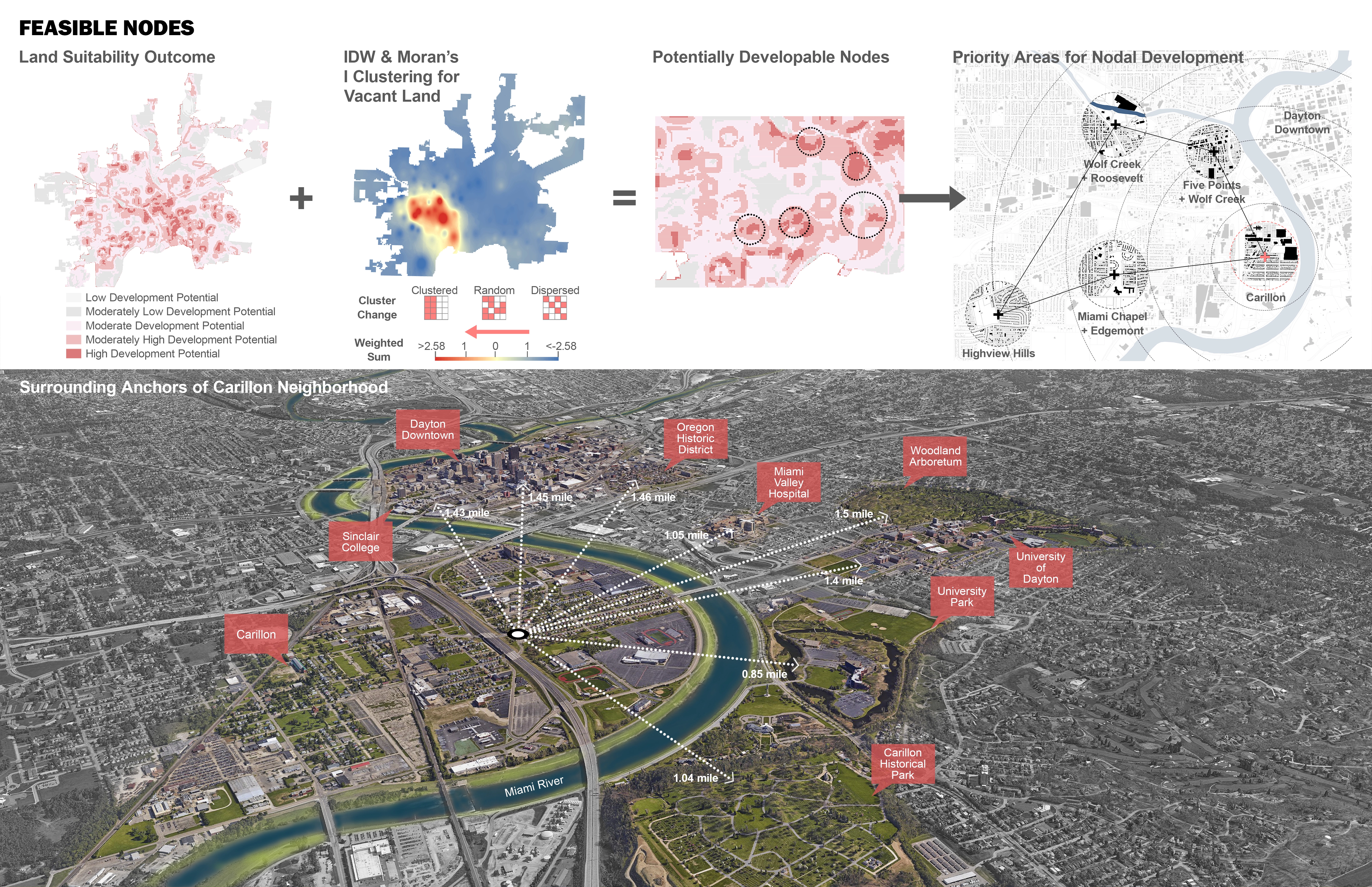
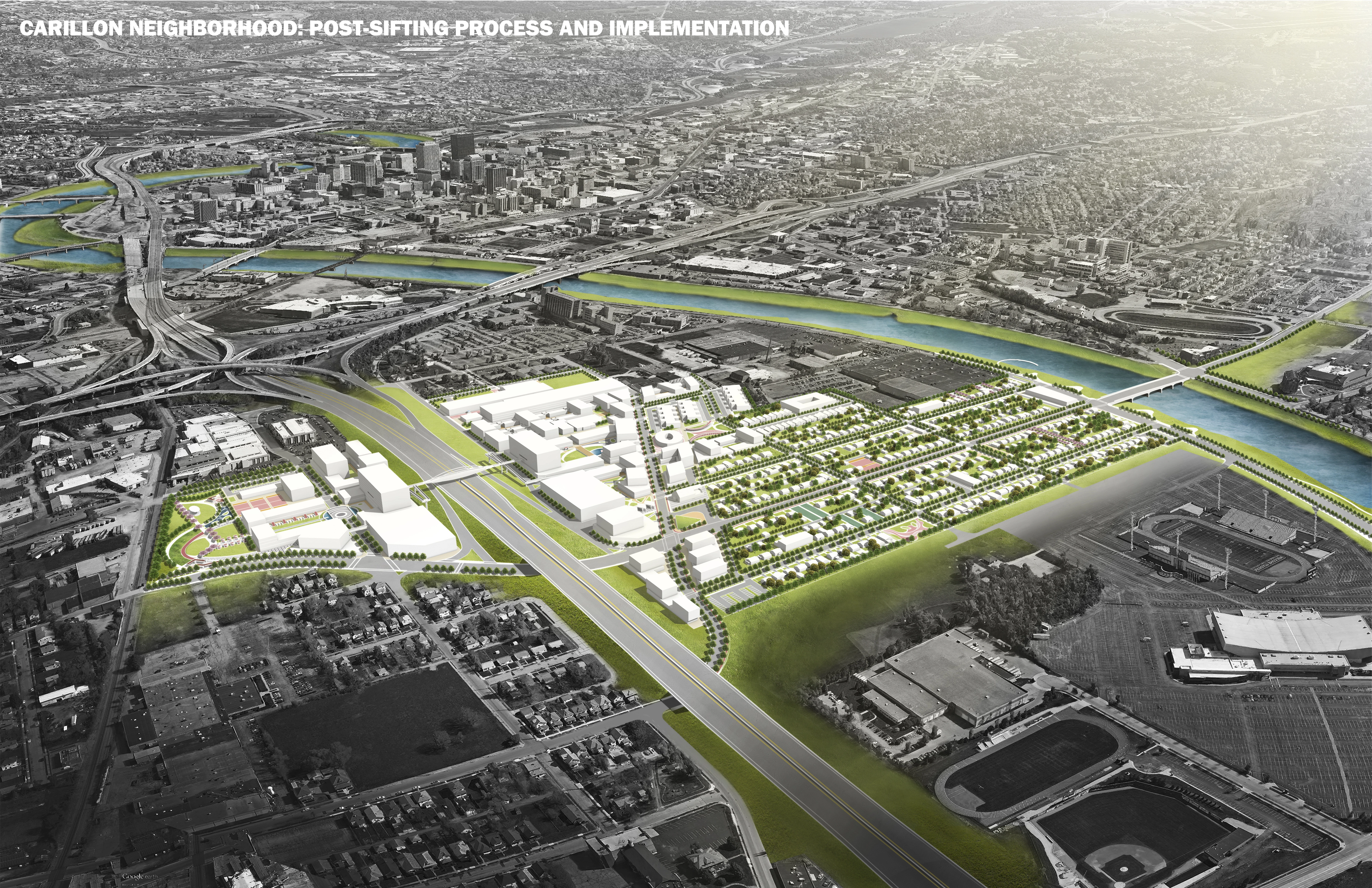
A suitability analysis was applied to determine where the highest developable areas are in the city, identifying five neighborhoods in the southwest of Dayton as highly developable. These five neighborhoods are targets for future nodal development. The Carillon neighborhood is adjacent to several major anchors within Dayton, including downtown, the Miami Valley Hospital, the University of Dayton and several major parks. Dayton’s city plan suggests to use universities, hospitals and schools as reinvestment anchors for stimulating adjacent vacant land regeneration.
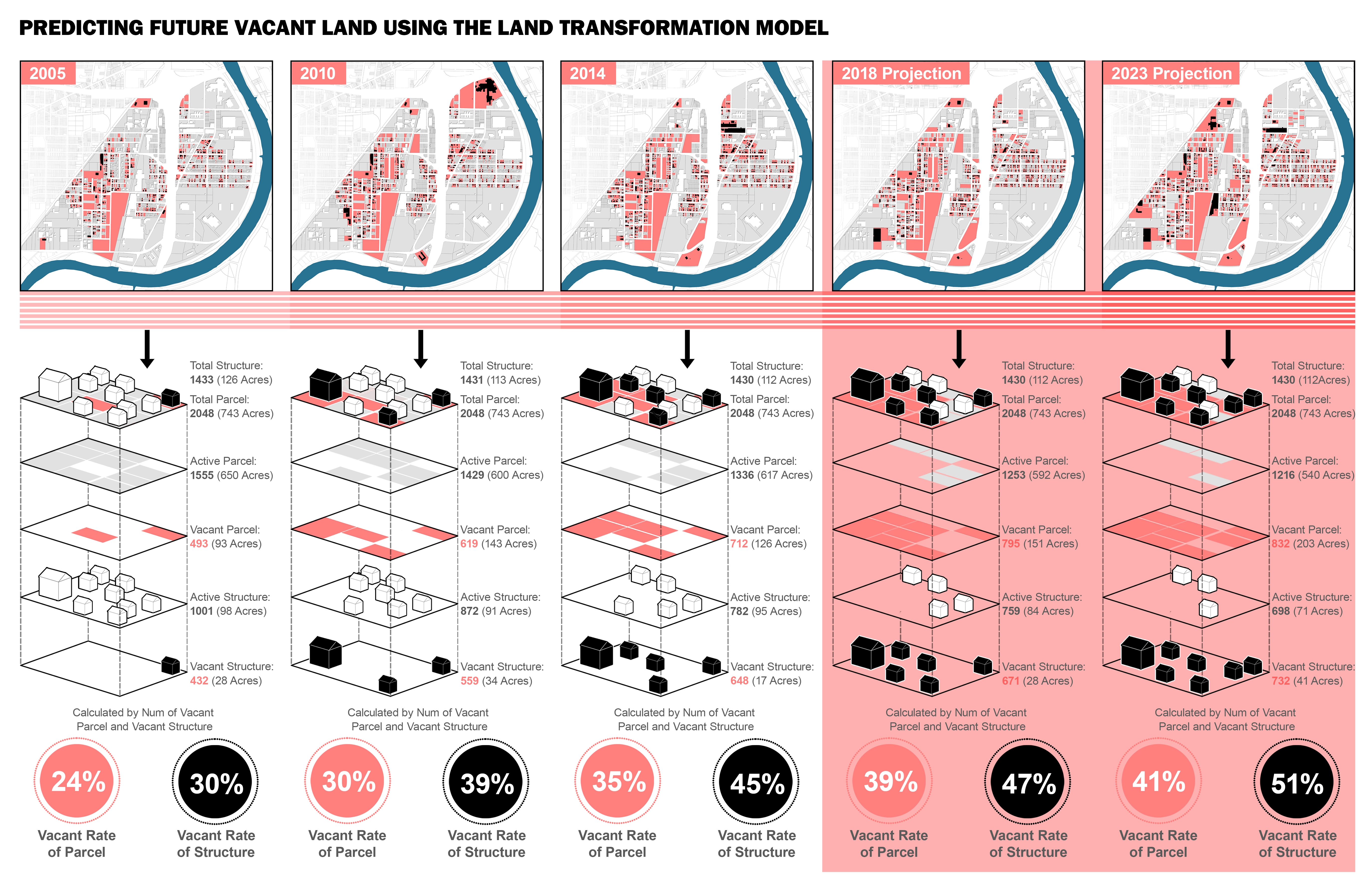
An aging population, a high-employment rate, a low-education level and low housing market conditions are the major characteristics of Carillon. As of 2014, its vacancy rate was 35%. As such, we determined which parcels were most suited for future decline. To predict vacant land, the Land Transformation Model (LTM) was employed. It is a GIS based land use prediction tool which simulates urban land use change based on land use change probabilities. The LTM estimates the impacts of changes, and forecasts future land uses following four steps: (1) input data is stored and managed, (2) predictor variables are examined, (3) the likelihood of change is derived and (4) the amount of land expected to transition is determined. Using this process, we predicted vacant lands for 2018 using patterns from 2005-2010 and 2023 using patterns from 2005 -2014. Multiple predictor variables such as distance from delinquent parcels, distance from commercial areas, distance from highway, distance from schools, appraised value, unemployment rate and vacancy rate were also employed. Prediction outputs suggest that the vacancy rate of Carillon will continue to increase, primarily in parcels on the periphery of the neighborhood.
Planning Strategy
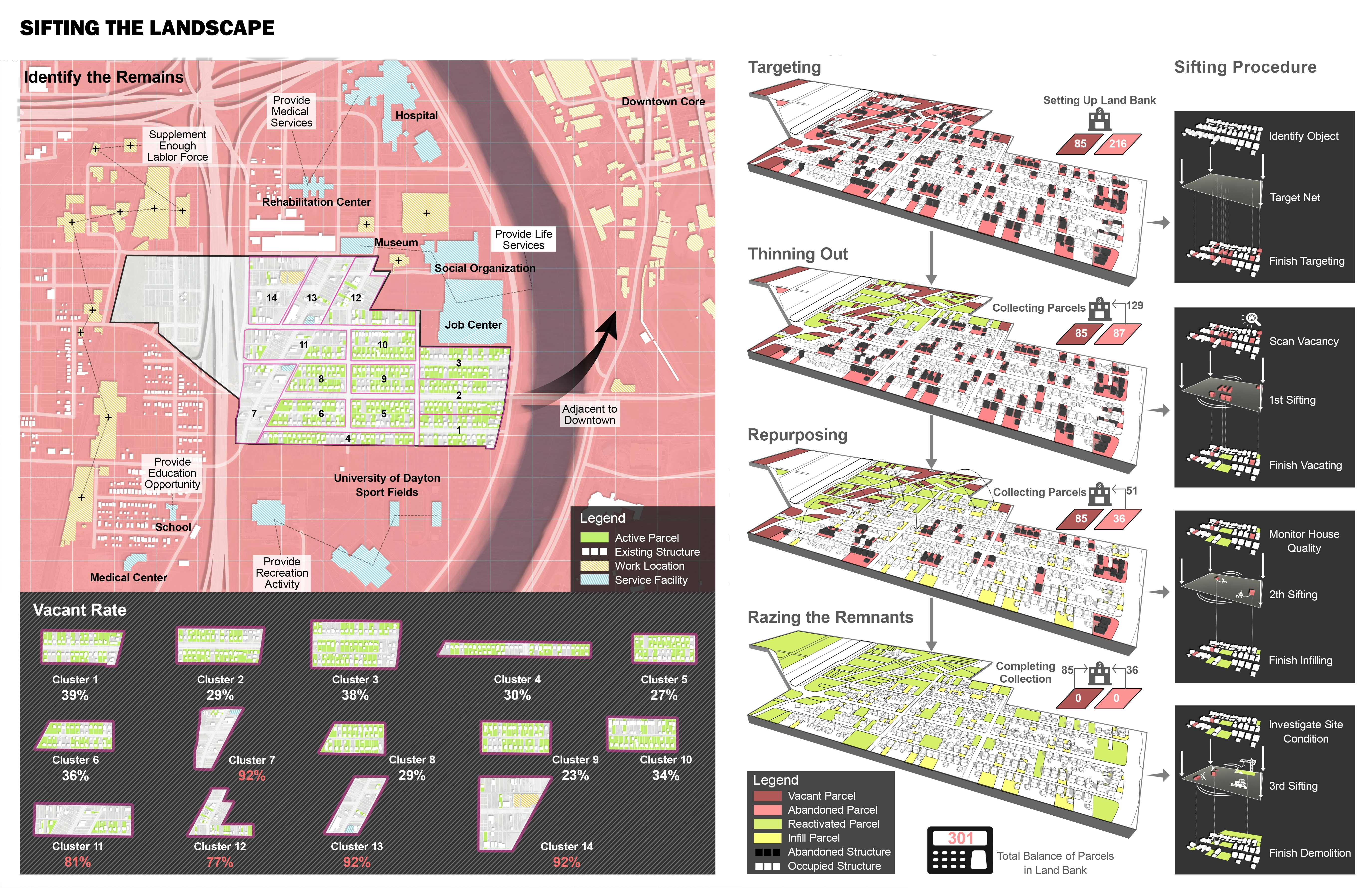
To determine the best method of future functionality in developmental or declining areas, we developed a framework which called “Sifting the Landscape,” a four step process to help regenerate vacant/abandoned lots.
Step 1: Targeting
Inventory existing vacant and abandoned lots and analyze the causes and social/economic costs of continued abandonment/vacancy. Historic data on public and nonprofit expenditures for relevant community and economic development are collected and land suitability analysis are used to prioritize areas of potential revitalization. Lands unsuitable for development and in decline are then recorded and registered as potential components of the city’s land bank.
Step 2: Thinning Out
Based on this inventory, blocks in which the vacant parcel rate exceeds 50% are then prioritized for renovations. The demolition of aging and worsening structures and land banking of vacant properties for better management and reinvestment is necessary in these areas. Simultaneously, lots located in low vacant parcel clusters are stabilized through rehabilitation efforts and housing assistance resources.
Step 3: Repurposing
Once thinned out, the reformation of zoning codes and new comprehensive plans to facilitate vacant property revitalization must be taken in to consideration to support neighborhood reinvestment plans and help attract private reinvestment. Comprehensive plans must ensure that revitalization and reclamation remain a top priority. For residents who live in highly vacant areas, financial provisions must be made to accommodate any relocation efforts necessary.
Step 4: Razing the Remnants
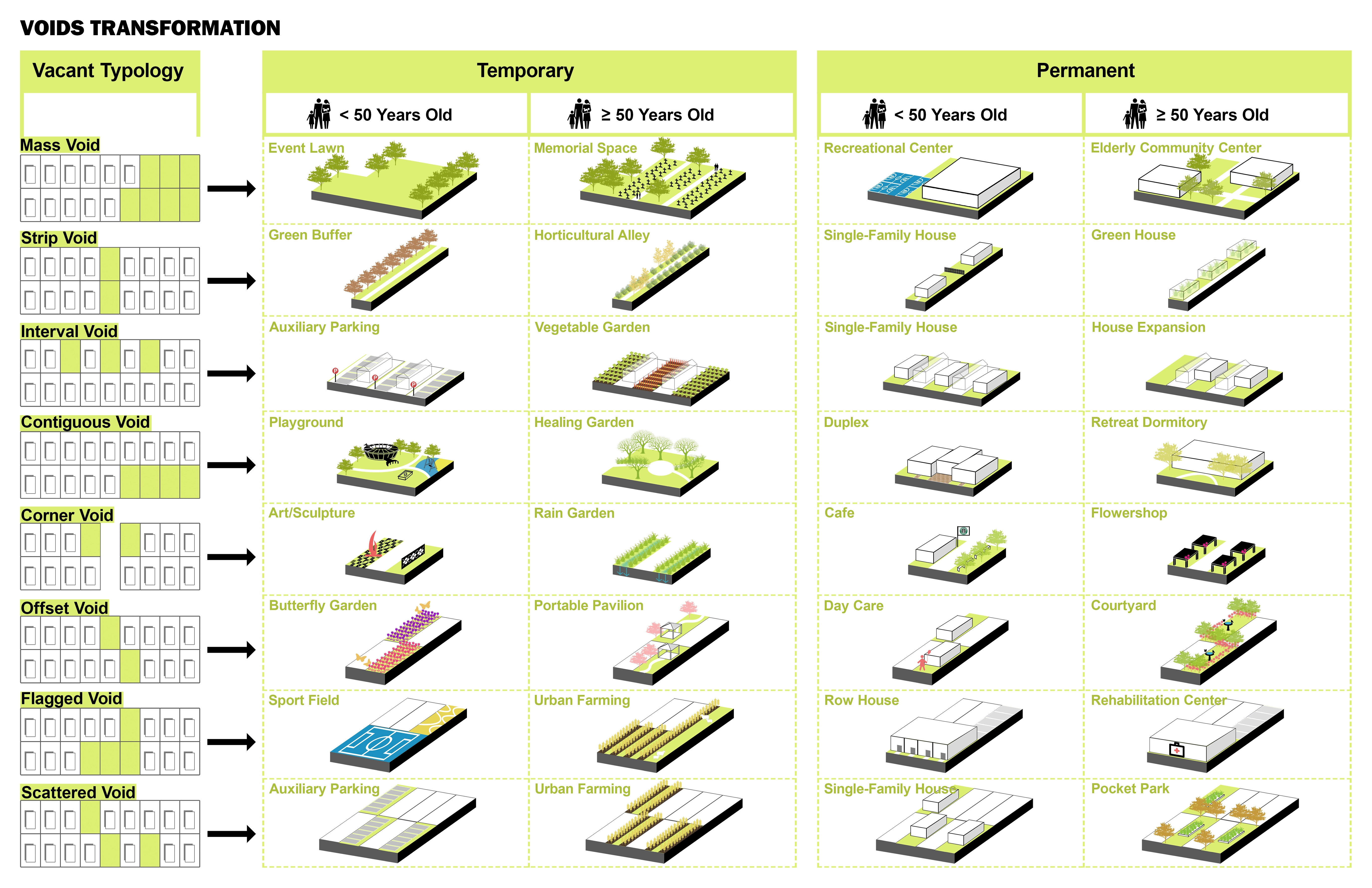
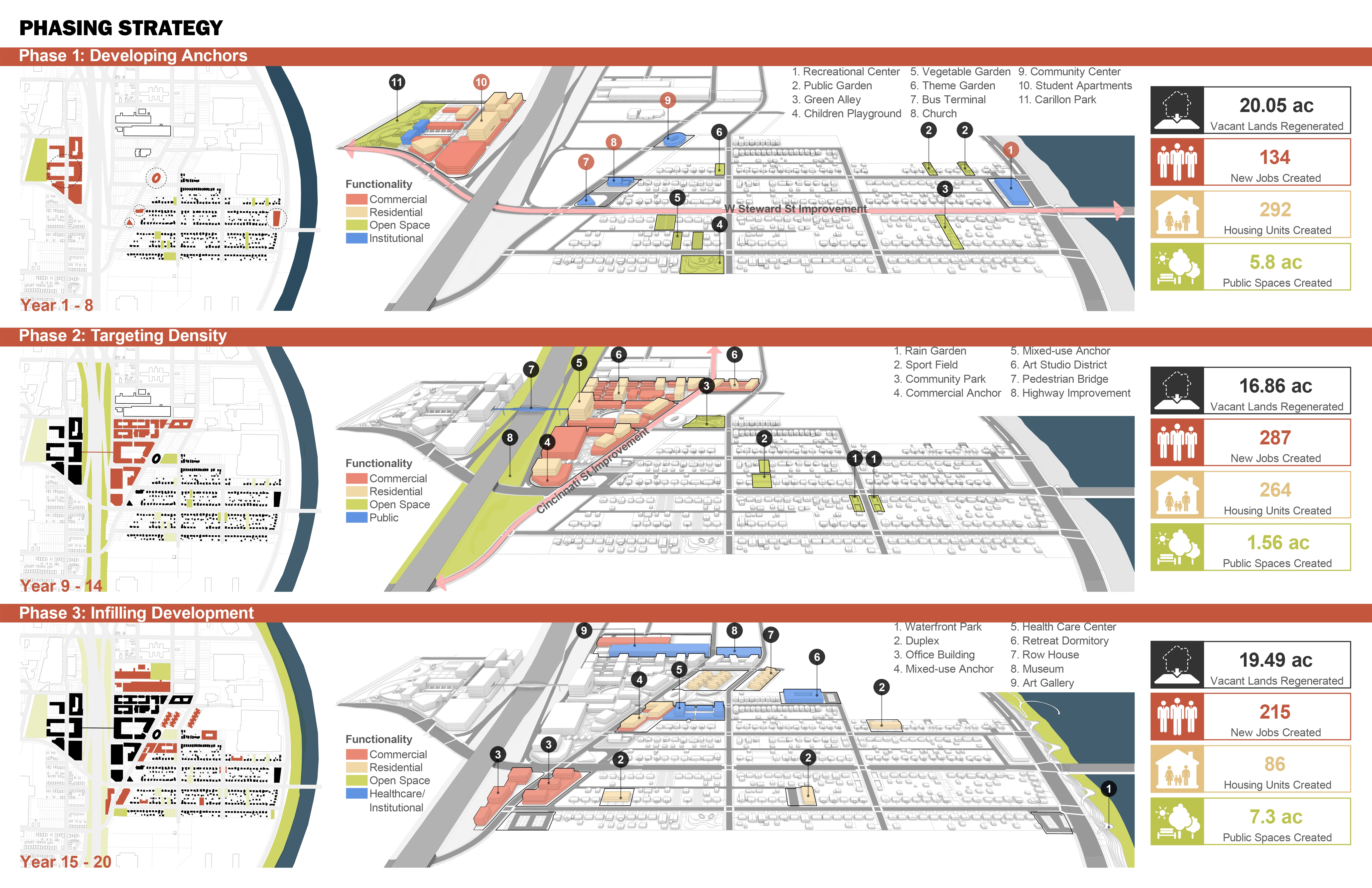
All remaining vacant and abandoned lands must then be preserved, retrofitted or cleared based on the efforts suggested from the repurposing phase. Once the sifting process is complete, a design strategy can be developed to implement temporary or permanent functions into the once vacant or abandoned properties. Currently, 301 parcels are managed by the city’s land bank to be resold or rented according to the comprehensive master plan of Carillon.
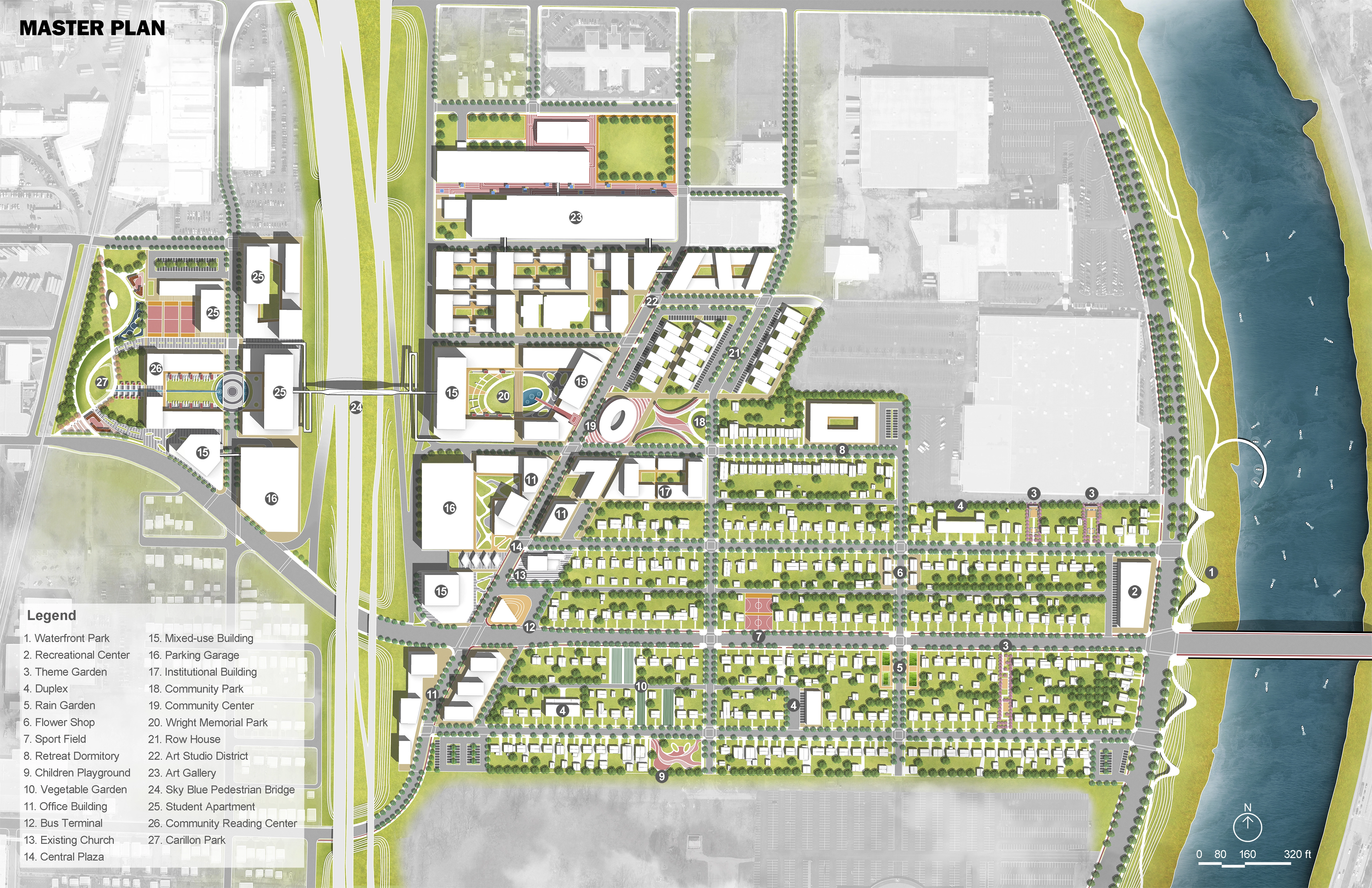
Design Schematics and Impact
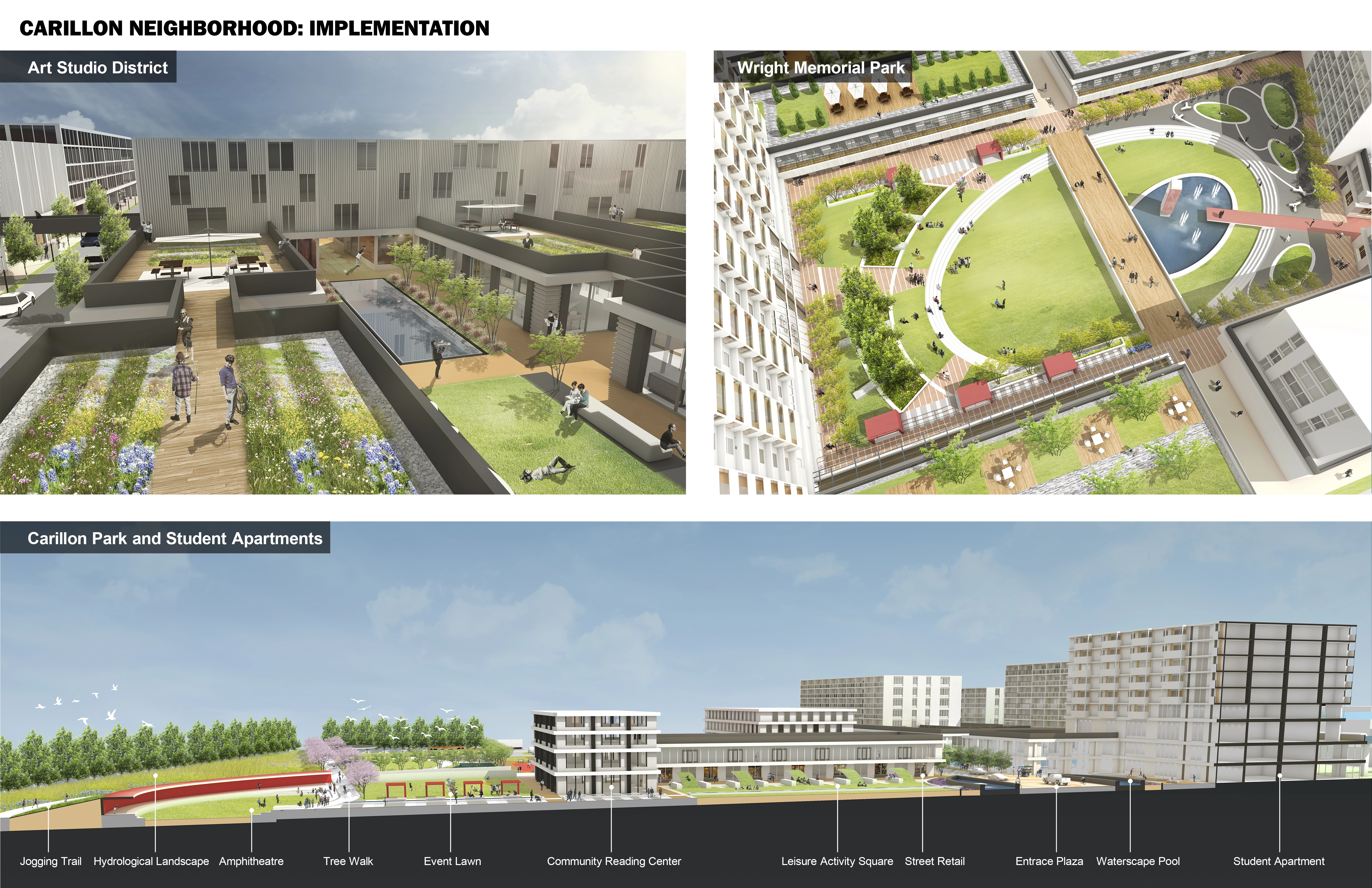
The design strategy for Carillion was to provide support functions to the surrounding developmental anchors while minimizing displacement of existing residents. West Stewart St. and Cincinnati St. will serve as the primary arteries to the design and create an important interchange for connecting local and national bus lines. In addition to preserving existing residential areas, mixed-uses will attract infill development and provide job opportunities for residents. Commercial uses provide basic job services and enhance the local economy while increased open spaces provide various activity spaces.
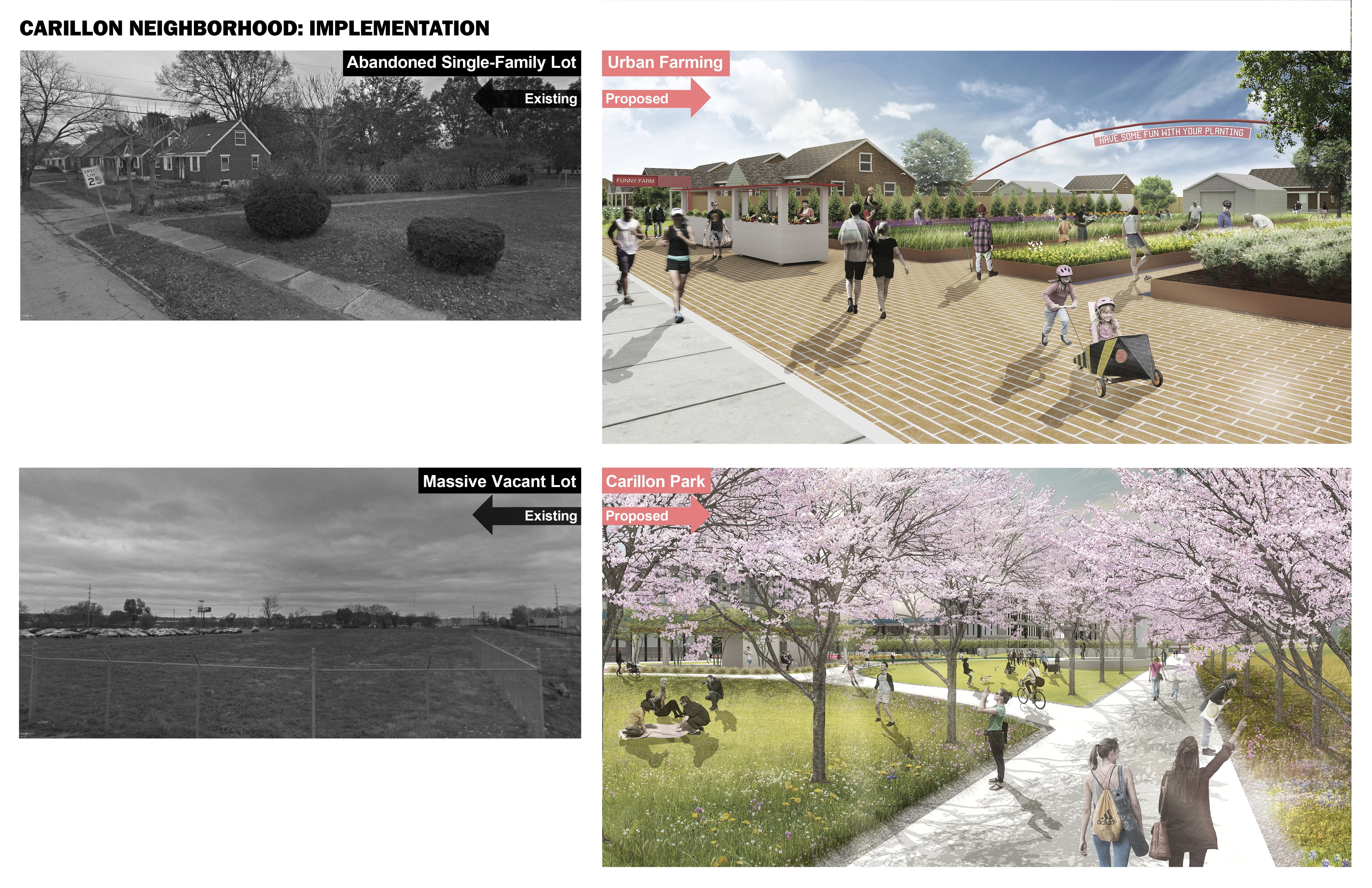
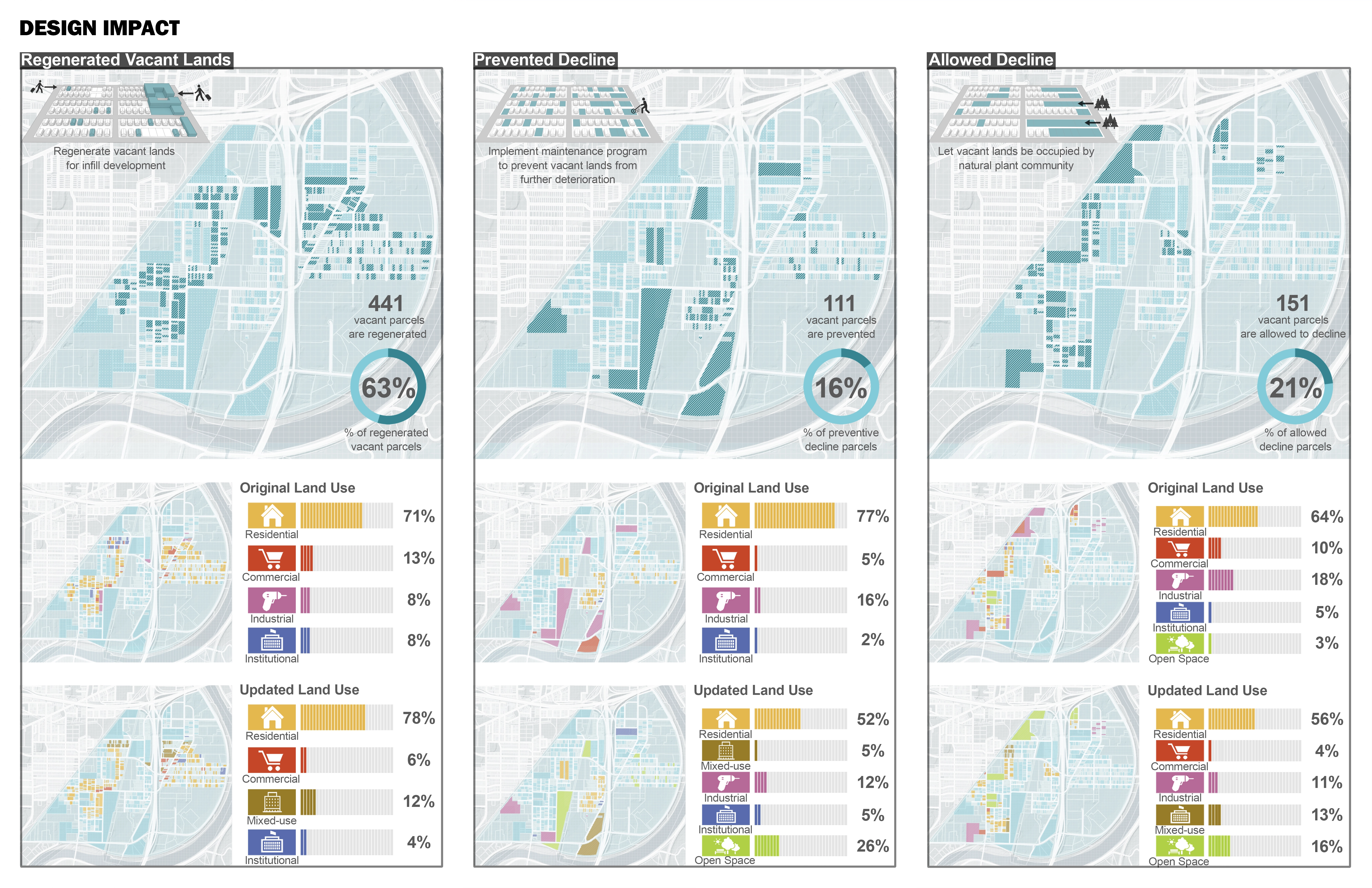
A riverside park connects to the Miami Valley Trail system and is a tourist attraction which provides residents with recreational space. For providing sufficient healthcare services for seniors, several buildings developed on vacant lots will function as a dormitory and healthcare center. Existing abandoned warehouses will be developed as art district while an obsolete governmental building is retrofitted into a community center. Student apartments will attract younger people from the University of Dayton and Sinclair College. In existing residential areas, interstitial vacant parcels are transformed into varying types of temporary gardens. According to the design, 63% of existing vacant lands will be regenerated through development, 16% will be prevented from further deterioration and 21% will be allowed to decline.
Advertisement
Related Awards

Honor Award, Analysis & Planning
A Cultural Approach: The Fort Peck Tribes Hazard Mitigation Plan
In collaboration with the Fort Peck Assiniboine and Sioux Tribes, EPA, and FEMA, the Fort Peck Tribes Hazard Mitigation Plan (HMP) adopts a culturally responsive approach to hazard mitigation planning that features connection to place.

