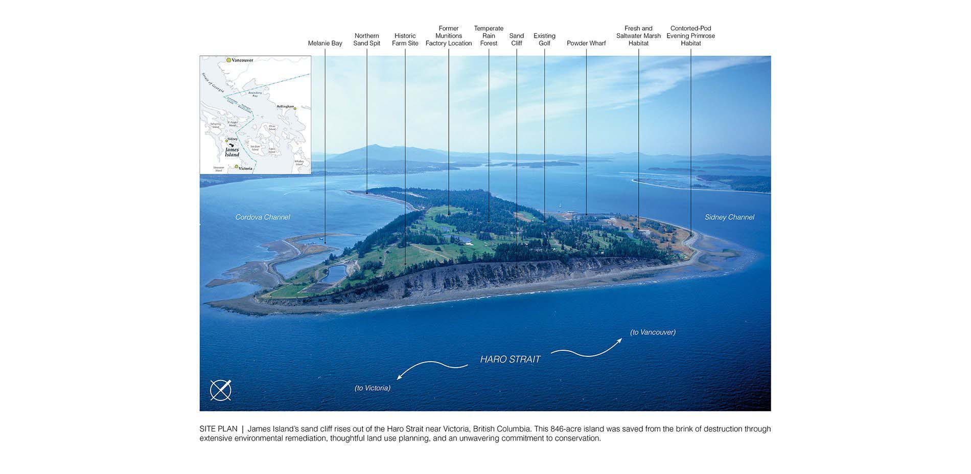
Site Plan. James Island’s sand cliff rises out of the Haro Strait near Victoria, British Columbia. This 846-acre island was saved from the brink of destruction through extensive environmental remediation, thoughtful land use planning, and an unwavering commitment to conservation.
Photo Credit: Sue Drinker
Media: Please submit high-resolution image requests to images@asla.org.
The intrinsic beauty and ecology of James Island was nearly lost to a Canadian explosives factory. Remarkably, the island’s fragile ecosystems survived are now protected through a new master plan and permanent covenants held by the Nature Conservancy.
Photo Credit: Client (above), Dick Durrance (below), Sue Drinker (lower right)
Media: Please submit high-resolution image requests to images@asla.org.
A wind shadow phenomenon caused by the tall sand cliff on the southern end of the island creates a localized area highly protected from the elements. This was a critical discovery as the team identified opportunities for indoor/outdoor experiences.
Photo Credit: Design Workshop, Dick Durrance (lower right)
Media: Please submit high-resolution image requests to images@asla.org.
Several weaknesses of the previous zoning plan were resolved to preserve the rural island character of the region through shared public amenity areas, community supported agricultural uses, and permanent protection for the spectrum of critical habitat zones.
Photo Credit: Design Workshop
Media: Please submit high-resolution image requests to images@asla.org.
Circulation is limited to small electric vehicles allowing the plan to be shaped around a network of small scale roads and open space connections, each with a unique landscape experience ranging from dense forest to grasslands to open coast.
Photo Credit: Design Workshop (lower left), Dick Durrance (lower center), Sue Drinker (lower right)
Media: Please submit high-resolution image requests to images@asla.org.
A commitment to conservation was defined by protecting nearly 20% of the island, including exceedingly rare estuary and dune ecosystems. Access to these areas was preserved for educational and research purposes by school children, university students, and environmental professionals.
Photo Credit: JLL Specializes Asset (upper left), Sue Drinker (lower left, center right)
Media: Please submit high-resolution image requests to images@asla.org.
Allowable density was significantly reduced and reflects a more thoughtful land use pattern. Limits on square footage for both residential and commercial uses, and an agricultural land reserve across nearly 50% of the island further ensure a minimal footprint.
Photo Credit: Design Workshop
Media: Please submit high-resolution image requests to images@asla.org.
Individual homesites were located using on-site micro-climatic field verifications in order to maximize the potential for open indoor/outdoor living spaces allowing residents and guests an intimate connection to the coastal landscape.
Photo Credit: JLL Specialized Assets
Media: Please submit high-resolution image requests to images@asla.org.
To minimize environmental impacts associated with transporting materials and laborers to construct site-build structure, all buildings must be prefabricated on the mainland, delivered via barge to the island, and then sensitively placed into the landscape.
Photo Credit: Client (lower left, upper and lower right), Studio Greene (upper left)
Media: Please submit high-resolution image requests to images@asla.org.
The sustainable coastal architecture of James Island is characterized by the re-use of local materials, green roofs, utilizing foundation piers rather than poured slabs, and thoughtful placement fully integrated into the native landscape.
Photo Credit: JLL Specialized Asset
Media: Please submit high-resolution image requests to images@asla.org.
James Island Village, nestled in the wind shadow from the sand cliff, forms the culinary and cultural heart of the community with organic gardens, orchards, artist studios, poolhouse with green roof, and a central gathering space.
Photo Credit: Design Workshop (left), CCY Architects (right)
Media: Please submit high-resolution image requests to images@asla.org.
The existing golf course was re-imagined to work in concert with the native landscape, rather than against it, and was converted to exclusively organic fertilizers, integrated pest management, and maintenance by electric vehicles and equipment.
Photo Credit: JLL Specialized Asset
Media: Please submit high-resolution image requests to images@asla.org.
A deep respect for indigenous cultures and a sustainable economy framed around local community-supported agriculture will supply residents not only with food, but a greater sense of purpose as members of the Gulf Islands region.
Photo Credit: Design Workshop (center left), Sue Drinker (center right), Dick Durrance (upper and lower right)
Media: Please submit high-resolution image requests to images@asla.org.


