Project Statement
Not every highway or large urban infrastructure
that divides a city can be buried underground or bridged
by a structure with a park on top of it. Such solutions
are often too costly, sometimes problematic, and possibly
far beyond necessary in most cases. In many instances,
reconnecting the severed urban fabrics of a city can
be done in beautiful, but simpler ways. Through my investigation
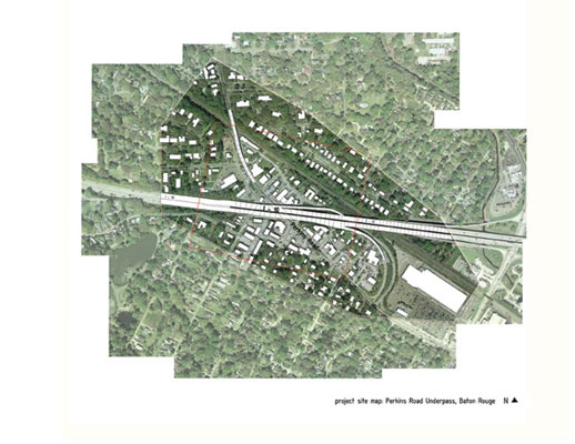
of an area known as Perkins Road Underpass in Baton
Rouge, my project investigated new possibilities in
reconnecting a city across a dividing infrastructure
system.
Project Narrative
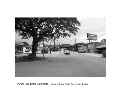
Many residents of Baton Rouge are familiar
with the uniqueness of the commercial district surrounding
the area where Perkins Road crosses under I-10. It has
a distinctive identity and it is identified as a special
place within the city. It is home to a thriving and
eclectic mix of local businesses which service the local
neighborhoods along with the wider city population.
It has a supermarket, a hardware store, a yoga center,
several hair salons, and some dry cleaners. It also
has a thriving nightlife with several restaurants and
bars that are local favorites. The area is the ending
point of a Mari Gras parade and the St. Patrick’s
Day Parade. It also has an emerging art scene with some
art galleries and the recent addition of a small art
festival. The underpass area has become very recognizable
as a place within the city. It is a point of destination
and it has tremendous potential as a cultural center
for the city.
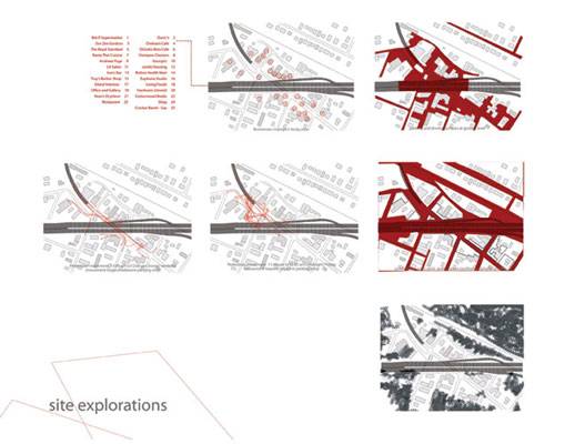
Despite the strength and character in
this district, it has weaknesses which prevent it from
living up to its potential and which could also endanger
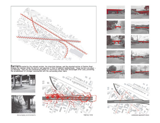
its future. The largest obstacle to the district’s
potential is the entanglement of roadway/railroad infrastructure
systems which cut through and divide district. In addition
to the elevated roadway of interstate I-10 running east
to west and dividing the site, there are entrance and
exit ramps which connect to Perkins Road from the highway,
there is a railroad corridor also running east to west,
and there is a portion of Perkins Road that is elevated
to bridge the railroad corridor. These structures are
defining elements for the underpass district, but they
also create physical and psychological barriers within
the district and between the district and nearby neighborhoods.
Bringing about reconciliation between these large structures
and the urban fabric they tear through requires thinking
about how the structures can be better connected with
the activity and the scale of the city and neighborhood
they cross, something which the structures around the
underpass currently do not do.
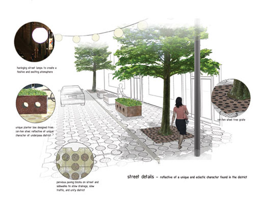
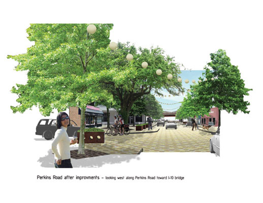
In addition to the barriers created by
the intrusion of these infrastructure systems, the district
has a more general weakness in the organization and
design of its connecting public spaces which also needs
to be addressed. The connecting spaces between the constituent
businesses of the district are haphazard and little
planned. This creates an ambiguity which weakens the
place’s overall physical identity. Remedying this
problem requires a focus on the delineation and the
aesthetics of pedestrian spaces. A stronger spatial
connection among the component businesses of the district
would strengthen its identity to visitors and also its
constituents and neighbors.
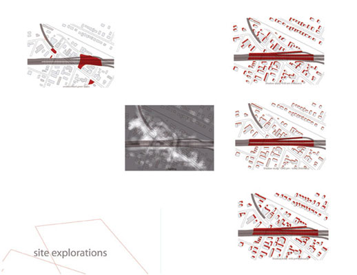
In creating a design solution and a plan
for the site, I developed three goals. First, I felt
that the design should seek to strengthen the site’s
inherent character rather than overwhelm it. Second,
the site should maintain its role as a neighborhood
center. Third, the design should create further opportunities
beyond its own solution.
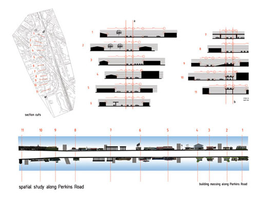
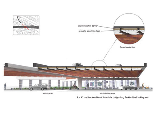
The most visible obstacle in the underpass
area is the underpass itself, where 1-10 bridges over
the district and Perkins Road. It is a highly visible
structure and creates a strong division between areas
to the north and south. It is easy enough to cross under
the bridge, but the noise, darkness, and material nature
of the space under the bridge are unpleasant and discouraging.
Despite the problems posed by the bridge, it is also
a defining feature and is a part of the districts identity.
Because of this, solutions to the problems caused by
the bridge should be found without hiding its identity
and altering what it is. My proposed design solution
utilizes a layer of noise reducing insulation and a
layer of acoustic absorption material to reduce loud
noise but also maintain the bridges structural identity.
The texture of the absorption material would become
an important part of the aesthetic design underneath
the bridge. A layer of spaced wood planks across the
bridge support beam perpendicularly, would reveal both
the absorption material and the bridge structural beams
above. Lighting above the planks would illuminate the
texture of the absorption material and lights below
would illuminate the wood planking and spaces below.
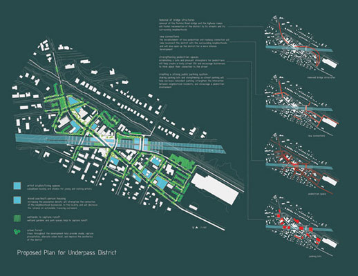
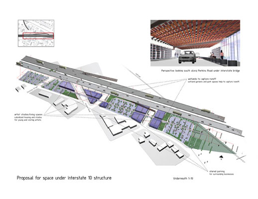
The space defined by the bridge can become
a pleasant place that creates continuity in the fabric
of the district rather than dividing it. For example,
building upon the emerging character of the site, with
the use of the noise reducing materials and the creative
reuse of the space, subsidized studios and living spaces
for young and visiting artists could be created. A unique
atmosphere with affordable living is often appealing
to young artists and could be the catalyst which develops
the district into the strong cultural center it could
be. In addition to studio spaces, green spaces under
the bridge composed of shade loving wetland plants could
be built which would absorb the water runoff that currently
collects under the bridge and would also help to create
a more appealing and connective space. Further building
upon the structure of the bridge, the division between
the east and westbound lanes which creates a strong
axis, could become an interesting walkway adding a new
dimension to the organization of the district.
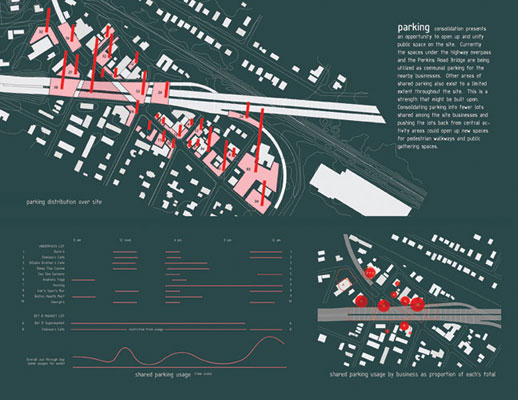
A particular strength of the site that
was observed early on was that many of the businesses
in the district share parking (albeit haphazardly).
In particular, much of the space under the highway underpass
is used for this purpose. This tradition on the site
has helped promote a sense of unity in the district
in some ways. Expanding upon this tradition, parking
areas could be consolidated further and moved back from
pedestrian designated areas to improve the connective
spaces between businesses. This would open up opportunities
to create a walkable atmosphere and would also open
up spaces for the creation of small public gathering
and event spaces. These spaces could be designed in
a way that reflects the unique and creative nature of
the underpass area and would also create a vibrant atmosphere
that would become an attraction for visitors and a pleasant
amenity for nearby residents.
I addition to the physical design of
public spaces in the district, policies to encourage
greater connection to a more pedestrian space could
be encouraged through the use of an overlay district
that would govern future development in the area. The
district could be used to create incentives and more
opportunities for entrepreneurs and creative industries
which would help maintain the underpass area as a location
for the unique and local. Additionally, such a district
could be used to encourage the type of building which
will embrace the district as a unified public space
and encourage its unity in the long term. Furthermore,
an overlay district would also increase local control
by businesses lying within its boundaries allowing for
a more deliberate form to development which could match
the goals of the district.
An important part of making any improvements
of course is financing. Financing can also play a part
in strengthening the ties between businesses and the
district. One method used might be tax increment financing
or TIF. A TIF district will allow the property taxes
from added value created by development in the area
to be utilized for improvements for a specified amount
of time. In short run, tax revenues would be diverted
to the district which would increase revenues for the
city in the long run as the improvement would encourage
new development in the district.
|