Project Statement
Led by landscape architects, this grassroots
collaborative planning process directly engaged hundreds
of multidisciplinary professionals and citizens to create
long-term plans for Seattle's interconnected "green
infrastructure." Both visionary and analytical,
the project innovated urban watershed-based planning
units, calculated long-term future scenarios, and incorporated
diverse stakeholder input. The resulting plans depict
comprehensive 20- and 100-year green infrastructure networks
in flexible, layered GIS maps and propose an illustrated
framework of transferable near-term strategies adopted
by the City.
Narrative Summary
Project Background,
Goals and Objectives
After celebrating the centennial of Seattle’s
Olmsted Plan in 2003, many city residents were left
wondering, “Where is the vision for our next century
of open space?” Despite palpable public interest,
neither civic resources nor municipal will were evident
to engage the question.
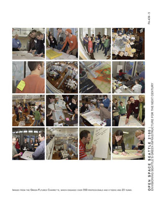
Without funding, client or mandate, Open Space Seattle 2100 (OSS2100) took up the mantle to engage the design/planning profession’s role as public advocate and educator. Stepping in to fill an evident void, we rallied thousands of dollars of grant and donor funding (including an ASLA CIP grant), engaged a wide spectrum of academic and professional design communities, provoked earnest interest and action from elected officials, and stoked the flames of popular imagination through the more than 350 participants in the Green Futures charrette. In doing so, we have begun to create a new paradigm for the ways that Seattle conceptualizes, funds, and prioritizes green infrastructure expenditures. But more than that, the ripple effects of Open Space Seattle 2100 and the resultant plan, The Living Lattice: A Network of Neighborsheds, has firmly rooted itself in the civic imagination of the city, and momentum continues to build for implementing a comprehensive, long-term green infrastructure plan for the city.
Not seeking
to find “answers,” our process was built
upon the promise of engaging the public to ask un-asked
questions. Through research, we brought precedents of
open space typologies and systems from around the world
to the fore. With invited lecturers, we energized and
excited the broader public community by introducing
innovative approaches and perspectives. By the end of
the process, the bounding energy of the public’s
engagement was overwhelming. Through the charrette process,
a cohesive vision materialized, and has been formally
integrated with the city’s future planning efforts.
But more important, this process empowered
the community of landscape architects and design professionals
to step out in front of policy makers and elected
officials to educate and inform the public, thus encouraging
the City to initiate dramatic new goals and approaches
for effectively implementing sustainable infrastructure.
As word of this effort spreads, cities both regionally
and nationally are now adopting the 100-year planning
concept, and are explicitly looking to our process of
engagement as a model.
The primary goal of Open
Space Seattle 2100 was to generate awareness and action
towards transforming urban space into a city's sustainable
"green infrastructure," to:
create a bold integrated Open Space
Plan with implementation strategies for Seattle's
next hundred years which will enhance the health and
well-being of both our cultural and natural environments.
This vision of a regenerative green infrastructure
will strive to create a healthy, beautiful Seattle
while maximizing our economic, social, and ecological
sustainability.
In this year-long process, objectives
were to: raise awareness of predicted future scenarios,
such as climate change and new demographics; proactively
propose new integrated design and planning solutions;
forge a striking vision of a potential interconnected
network of open spaces; and to highlight the leadership
role of landscape architects in (re)shaping the quality
and sustainability of urban development. In the process,
other objectives were achieved including illuminating
connections between open space, density, livability,
and sustainability; creating a context where diverse
professionals and citizens would convene to exchange
ideas and develop new relationships; and catalyzing
a long-term advocacy coalition and planning process
to advance the quality of Seattle's integrated open
space.
Programming, Inventory, Analysis,
and Public Engagement
This phase included:
1. Preliminary consultation with numerous stakeholder
focus groups, including City staff, non-profits,
underserved and minority groups, and concerned citizens.
This was followed by the formation of a coalition
advisory group of over 50 organizations. This
group assisted in crafting eight Open Space
Principles that were subsequently endorsed
by Seattle City Council, and helped articulate our goals,
objectives, and the future scenarios that charrette
participants would use.
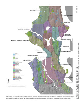
2. For the first time in Seattle city-wide
planning, we used the underlying anatomy of the landscape
as the basis for partitioning the city. By dividing
the city into 18 urban watershed study areas,
we broke new ground in approaching urban planning by
using watershed units rather than political boundaries.
This natural framework helped participants to transcend
traditional social rivalries while illustrating critical
ecological and mobility connections within and between
watersheds.
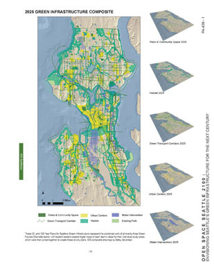
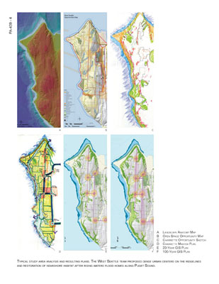
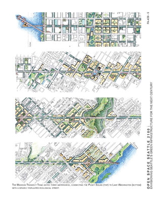
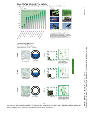
3. Inventory and Analysis
was conducted for each watershed study area, using GIS,
research, and local knowledge. We produced "dossiers"
of background information and a carefully developed
large-scale GIS "Opportunity and Constraint"
maps for each watershed study area. The analytical
base mapping displayed relevant spatial information
to inform charrette participants, illustrating information
that is typically not considered by city residents as
they conceptualize the city, including existing parks
and open spaces; water bodies and buried streams; projected
urban growth areas; designated transportation, bike
and pedestrian routes; land cover and uses; and hazard
zones such as earthquake faults and steep slopes. Some
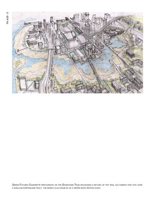
teams mapped predicted conditions, such as higher shoreline
water levels anticipated for year 2100.
4. Research and Development of Planning
Tools. In addition, we produced the "Green
Futures Toolkit" to inspire and inform
charrette participants. The Toolkit contained case studies
of over 16 exemplary urban open space systems, an illustrated
typology of 23 open space types, and a menu of implementation
mechanisms, as well as the Charrette Brief conveying
future scenarios and production requirements for each
team.
5. Public Education:
We sponsored a four-part public lecture series
with nationally-known speakers addressing issues of
environmental and social significance, and a local panel
to convey important technical and environmental
issues. In all, over 1000 people attended the
public lectures. We also posted the full Green Futures
Toolkit on our website (open2100.org)
and maintained a blog summarizing relevant
issues, research, and events.
Design as a Planning Method
The project merged both planning and design methods,
borrowing the design charrette model
and developing design ideas while adhering to sound
planning principles and protocols. With the
involvement of numerous design professionals on each
team--often led by landscape architects--the design
process easily came into play during the 2-day
charrette. We gave the 23 teams future scenarios
and copies of the Green Futures Toolkit and asked them
to concur on goals, propose concepts, and develop interconnected
green systems that linked to neighboring watersheds
and to overall city networks. Over the course of the
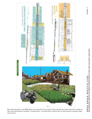
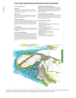
two days, teams drew 100-year and 20-year plans with
priorities for immediate implementation. This positive
collaboration and common ground resulted in strong
overall concepts and rich illustrative drawings.
Follow-up development by student leaders further illustrated,
extended, and tested design ideas and prototypes.
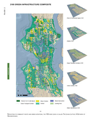
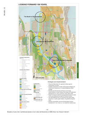
At a planning level, we converted plans
from the charrette into GIS databases,
using consistent criteria and legends for each watershed
so that all 18 watersheds could be merged onto drawings
showing the whole city, on both 20-year and 100-year
horizons. These databases are deeply layered, so that
they can digitally reveal the richness of ideas represented
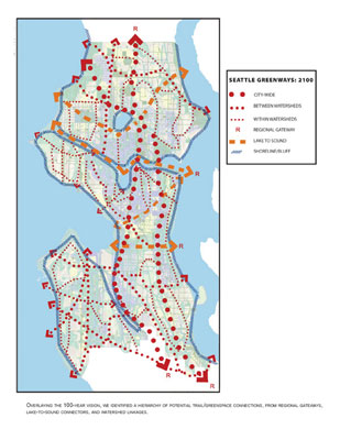
in each area of the city. We further analyzed the plans
to identify a hierarchy of potential connective
pedestrian and bicycle corridors, from regional gateways
and "Lake to Sound" trails, to inter-and-intra-watershed
loops.
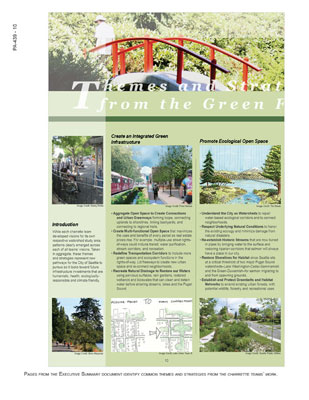
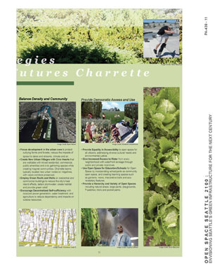
The depth and range of the teams' design
solutions provided fodder to craft a set of 17 strategies
for urban green infrastructure transferable
to any city. We grouped these under the themes of Create
an Integrated Green Infrastructure; Promote Ecological
Open Space; Balance Density and Community; and Provide
Democratic Access and Use.
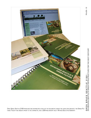
We documented these illustrated strategies,
the final collated plans and ideas for each watershed
study area in a 230-page report, titled Envisioning
Seattle's Green Future: Visions and Strategies from
the Green Futures Charrette, which can
now be found in libraries and neighborhood community
centers throughout the city. We also produced and broadly
distributed a 16-page Executive Summary
with the same title, containing the full report on a
cd.
Outcomes, Implementation, and Value
to the Client
With commitment and a clear implementation strategy
developed by coalition representatives, Open Space Seattle
2100 has already effected a host of outcomes and catalyzed
a series of actions:
Actions by the City of Seattle
Seattle City Council unanimously endorsed the
project's Eight Open Space Principles. Most
recently, the Council passed a multi-pronged resolution
directing City departments to incorporate OSS2100
goals and green infrastructure concepts
into their planning and to identify a citizen's advisory
process to assist the City in implementing green
infrastructure strategies. As a result, already
the City is developing a process for employing a sustainable
infrastructure approach to Capital Improvement
Projects (CIP), integrating departmental projects and
including social and environmental benefits
in their asset management program. The City
intends to emphasize management of the 30 percent land cover
in public ownership (including street rights of ways)
as multi-functional open space; this
represents a dramatic paradigm shift from traditional,
myopic departmental views. The City also will evaluate
cost-benefits of green infrastructure and identify best
practices in other communities. Additionally, the GIS
databases from The Living Lattice
plans are being used in the current Bicycle Master Planning
process.
Non-profit and University Advocacy
and Research
Spin-off from the OSS2100 process has catalyzed and
informed numerous non-profit efforts in the city. Two
new non-profits have taken on advocacy of the OSS2100
strategies as major components of their missions.
Several local groups are using the specific watershed
plans in their ongoing planning efforts and
are beginning to use grant opportunities to implement
some of their visions. Ideas from the charrette have
been added to the recently completed "Bands of
Green" 20-year trail proposal
sponsored by the Seattle Parks Foundation. A new university
institute to focus on green infrastructure research
and design has formed and has partnered with
the city to investigate the potential for stormwater
mitigation and other ecological approaches to the design
of city streets.
Replication by Other Cities
In the past six months the project has been disseminated
locally, nationally, and internationally, in numerous
publications and presentations.
San Francisco, Wichita, KS, Kobe Japan, and local communities
are already explicitly borrowing our principles
and processes, and we are being asked to apply
the process at both larger and smaller scales locally.
Public Benefit
Perhaps most significantly, citizens' views of what
is possible in their city's future have changed. One
seasoned open space advocate observed, "Life
is not the same after being asked to envision Seattle's
open space in 100 years." The City's Director
of Planning takes the long view, commenting:
"I hope that 100 years
from now, people will say they appreciate the farsighted
legacy that Open Space Seattle 2100 left to the city."
|