Problem Researched
From the fringes of its urban areas to its extensive northern and southern forests, critical natural landscapes across the Midwestern US are becoming increasingly transformed by development. Sometimes abrupt and sometimes subtle, these landscape changes are having unintended consequences on the valued natural character of the region. As a result, people who look to the natural landscapes of the region for their livelihood and their leisure are finding the very characteristics and experiences they desire are changing rapidly or disappearing altogether. Changes caused by landscape fragmentation and urban sprawl can result in reduced quantity or quality of resources, decreased access, and higher costs. These impacts affect a wide range of commodity, environmental, recreational, community, and governmental interests, and have significant implications for landscape design, planning, management, and policy.
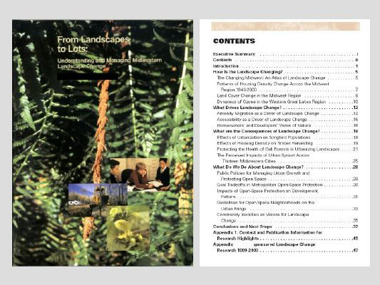
A solid program of research is needed in order to guide landscape change and make appropriate decisions about the future. This has been a key message of the ongoing Landscape Architecture Foundation’s Futures Initiative, which has also underscored the need for landscape architects to collaborate with others in the natural and social sciences and design professions to address complex issues relating to landscape change. It is in this same spirit that the Landscape Change Integrated Research and Development Program (LCIP) was initiated. In 1999 a group of federal agency researchers joined together across disciplinary lines in a coordinated effort to examine critical questions related to landscape change across a 7-state region of the Midwest. Led by a landscape architect and an environmental economist, our team has gone on to build a body of applied research relevant to stakeholder needs. Although the program continues to grow and evolve, this data summary focuses on work accomplished during the first five years (1999-2003) as summarized in the From Landscapes to Lots publication (Figure 1).
Relationships Investigated
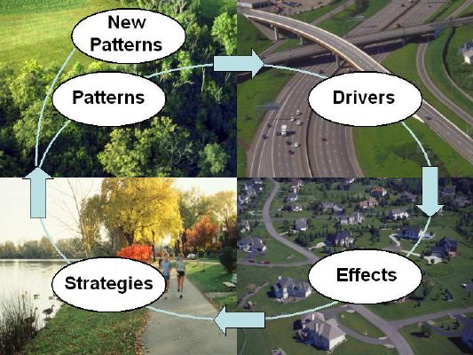
To identify key questions for research, we developed a process model for understanding landscape change (Figure 2). This model views landscape change as a process where patterns of change result from one or more driving forces of social, economic, or technological origin. These changes may have effects on people and ecosystems, sometimes for the better, but the changes that concern most resource-oriented stakeholders are often expressed as negative impacts. As depicted by the looped model, strategies undertaken to address the consequences of change feed back into the model, resulting in new landscape patterns and altering the trajectory of the change process. Four main questions resulted from this modeling process, each with a number of sub-questions responding to stakeholder needs:
- How is the landscape changing? What are the critical patterns of landscape change? Where are today’s hotspots of change and how can we predict future ones?
- What drives landscape change? What forces drive landscape change? How do such drivers as landscape attractiveness work in concert with technological change and the aging population? Do people's perceptions of changing landscapes drive further change?
- What are the consequences of landscape change for people and ecosystems? How does the quality of people’s lives change? How are plant and wildlife communities impacted? How resilient is the transformed landscape, and how well does it serve societal and ecological needs?
- What do we do about it? Growth management tools abound, but how well do they work? How can communities benefit economically without losing local character and quality of life? How do we mobilize new landowners to collectively maintain healthy landscapes? In what capacities can landscape architects and others work most effectively?
Methods of Inquiry Used
Our research program began with meetings and discussion among internal and external stakeholders to identify priority projects within each of the four question areas. Because the LCIP was conceived of as an integrated research program, some projects brought multiple talents to bear on broad research questions. Other projects had a more narrowly focused target, and integration was achieved by synthesizing study findings through various communication products. In both cases, an LCIP competitive funding source supplied an initial incentive for collaboration between research participants, many of whom came together for the first time to address common problems. This seed money provided a catalyst to leverage additional research funds, and in the program’s first five years $.56 million in dedicated program funding was matched by $3.4 million in contributing funds by federal agency collaborators and another $2.5 million by cooperating public and private institutions for a total of more than $6.4 million for research.
Research methods for individual projects ran the range from analysis of county-level resource and demographic data to look at broad scale changes across the 7-state region over time to detailed bird nesting surveys and stakeholder focus groups to identify the impacts of change within critical populations or case study locations. While researchers were guided by quality control and peer review processes to maintain a high degree of scientific rigor in their work, they were also challenged by participating practitioners and administrators to answer the “So what?” questions and make their work useful and accessible to designers, planners, managers, and policy makers. Involvement from a number of landscape architectural researchers and those from other applied professions also helped to challenge the team’s work for relevancy and applicability.
Results of Research
The LCIP sponsored 91 studies over the period 1999-2003. While several of these projects are still in progress, the program to date has provided solid research information in each of the four question areas. Representative projects are described below and in the accompanying figures:
Highlights of Findings:
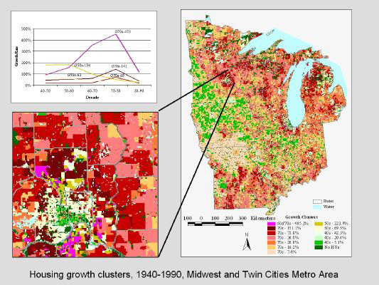
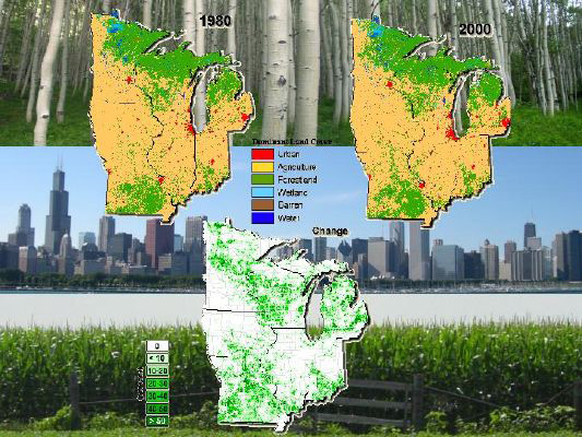
- How is the landscape changing? Our research has helped identify the critical patterns and trends of changes in the Midwest region over recent decades. Detailed information on housing density and land cover (Figures 3 & 4), and county data on forest characteristics, plants and animals, and human demographics have been organized in a web-based atlas available to researchers, planners, and decision makers. Studies on other critical patterns such as ozone levels are helping to understand trends and linkages beyond the region.
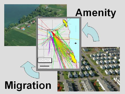
- What drives landscape change? Physical, biological, social, and economic factors combine in complex ways to draw people to locations within the region not only to visit, but also increasingly to build primary residences and second homes. This amenity migration has traditionally centered on the riparian areas within the region but is increasingly spreading to forest and agricultural areas of the urban and rural fringes (Figures 5 & 6).
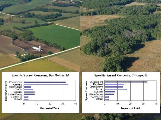
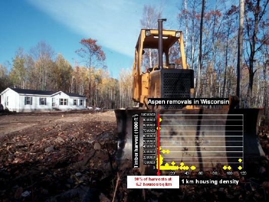
- What are the consequences of landscape change? Forest parcelization and low-density development patterns are affecting the people and ecosystems of the region. At the urban fringe, forest fragmentation is reducing songbird populations and the health of oak ecosystems. There also are concerns in more rural areas, such as economic impacts to the forest industry as increasing housing density results in fewer timber removals (Figure 7). Concerns about sprawl among metropolitan residents have increased across the Midwest region, with the perceived effects on environmental quality, farmland and open-space protection, traffic, and other problems varying in intensity from city to city (Figure 8).
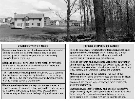
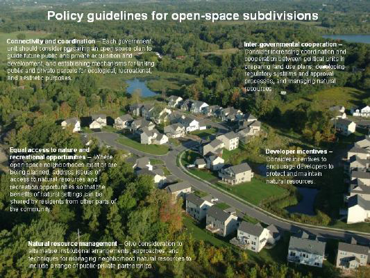
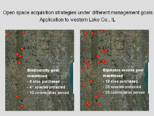
- What do we do about it? Strategies for avoiding, minimizing, or ameliorating the negative effects of landscape change include policies aimed at protecting open space by regulating land use, providing incentives to landowners and developers, and educating homeowners (Figure 9). The effectiveness of many open-space protection strategies has not been tested, but approaches that integrate multiple tools and authorities have the highest potential for succeeding. Understanding the goals of planners and residents can go far to achieve long-term, effective, and equitable guidelines for landscape change (Figure 10).
Impact: These findings are further summarized in the From Landscapes to Lots publication and in an accompanying website, and are detailed in more than 70 scientific articles published thus far. The following products exemplify the impact the LCIP is having:
- A special double issue of Landscape and Urban Planning on the “Social aspects of landscape change” describes causes, consequences, and solutions relevant to better understanding the relationships between people and urbanizing landscapes. Seven of the issue’s 13 articles remain listed among the 25 most downloaded articles on the journal’s website.
- Web-accessible regional maps of housing density change from 1940-2000. Methods originally developed for the LCIP have become indispensable to the federal National Fire Plan for identifying communities at risk of wildland fire and have been applied nationally.
- An interactive element of the web-based atlas mentioned above lets users select from a list of city names to view hotspots of rapid land cover change and generate maps and data tables of land cover change for 1980-2000 for any user-defined area. This effort won a major federal agency award for putting research information into the hands of users.
- A multimedia CD entitled Oak Wilt: People and Trees—A Community Approach to Management details Best Management Practices to halt the spread of Oak Wilt in urbanizing landscapes. The CDs have been widely distributed to landscape architects, developers, planners, urban foresters, and other key audiences.
Role of the Landscape Architect: Landscape architecture is prominently represented in LCIP efforts. In addition to the program’s co-leader, the LCIP has collaborated with 11 principal investigators from landscape architecture programs at eight universities. Across 15 different projects, this work demonstrates the contribution of landscape architectural perspectives to research in landscape change and illustrates the range of topics that constitute landscape architectural research. Example project titles include:
- Aligning social and ecological drivers of urban landscape change;
- Predicting scenic perception in a changing landscape;
- Nature at the urban edge: Ecological-psychological values;
- Community identities as visions for landscape change;
- Conflict in interface forestry: Nature, science, and landscape change;
- Integrating social values in landscape change assessments; and
- Comparing perceptions of riparian function to assessed values and conditions: Management in a changing landscape.
Conclusions
The Landscape Change Integrated Research and Development Program has helped to build awareness and provide information and tools to designers, planners, managers, and policymakers for understanding and guiding development oriented landscape change in the Midwestern US. While the research program began as a largely regional effort, several of its products and findings have made an impact nationally and internationally. As an interdisciplinary collaboration, the LCIP has brought diverse talents together to address complex social and environmental issues that transcend disciplinary and professional boundaries. While landscape architecture has been viewed as an integral player in the mix from the start, as the program evolved participants have come to even more fully appreciate the value of landscape architectural research perspectives in understanding the dimensionality of problems and issues in landscape change.
Landscape architecture has an important role to play in landscape change research, but it is also the role of the profession to bring the fruits of this research into practice and policy for responsibly guiding future development of the landscape. Through initiatives such as the LCIP and LAF’s Futures Initiative, the linkages between research, practice, and policy can be strengthened.
 |
|
Steering Committee: Thomas R. Crow, John F. Dwyer, Eric J. Gustafson, Robert Haack, Warren E. Heilman, Pamela Jakes, Dennis May, Frank R. Thompson, and J. Michael Vasievich.
Principal Scientists: David Bengston (Ecological Economics), Joseph Charney (Meteorology), Thomas Crow (Landscape Ecology), John Dwyer (Urban Forestry), Paul Gobster (Landscape Architecture), Eric Gustafson (Landscape Ecology), Robert Haight (Forest Economics), Warren Heilman (Meteorology), Pam Jakes (Forestry), Jennifer Juzwik (Forest Pathology), Charles Michler (Forest Genetics), Robert Potts (Social Science), Thomas Schmidt (Forestry), Herbert Schroeder (Environmental Psychology), Stephanie Snyder (Operations Research), Susan Stewart (Recreation Research), Frank Thompson (Wildlife Ecology), Lynne Westphal (Urban Planning), Patrick Zollner (Landscape Ecology)
Communications: Deb Dietzman, Group Leader, Sharon Hobrla, Information Technology Specialist

|
|
|
|
|