
.webp?language=en-US)


Dredge Ecologies: Climate-Adaptive Strategies for a Changing Island in a Changing Climate
Marybeth Campeau, Student ASLA

This project addresses the challenges involved in managing a landscape that is constantly evolving. The analysis and presentation of advanced and complex information are consistently clear. Every image and diagram is carefully organized and supports the overall plan and guiding concepts with apparently no extraneous information. Most impressive is how it successfully targets its audience--the local community who can actually use the information.
Awards Jury
-
For the past decade, a community coalition has fought to protect Eagles Island, the largest island in a deltaic archipelago at the confluence of the Cape Fear and Northeast Cape Fear Rivers, as a recreational amenity. Located 20 miles from the Atlantic coast and nestled between the two most rapidly growing counties in North Carolina, Eagles Island exemplifies the anthropogenic challenges and opportunities faced when analyzing and planning for sea level rise. With threats of private development looming, this project provided the local coalition a compelling and comprehensive vision for the island that embodies the mission of conserving and managing the land’s natural and cultural assets and providing compatible educational and recreational activities.The project’s framework blends multiple levels of meaning to (re)imagine a future that acknowledges and builds upon cultural histories, resulting in a program that fosters climate-adaptive, ecologically rich, and biodiverse habitats using dredged material. Through a process that holistically assessed the island’s evolving history, this project grounds conceptual design solutions in a systems-based plan to make the vision a resilient reality.
-
An Island Manipulated by Cut and Fill
The history of dredging on and around Eagles Island has ravaged its landscape in the service of economic priorities. This project grapples with the 3220-acre island’s centuries-long relationship with cut and fill for capital gain in a dynamic riverine system. The proposed framework flips the script and considers the impacts of redistributing remediated dredged sediment with nature-based solutions that support ecological and community wellness.
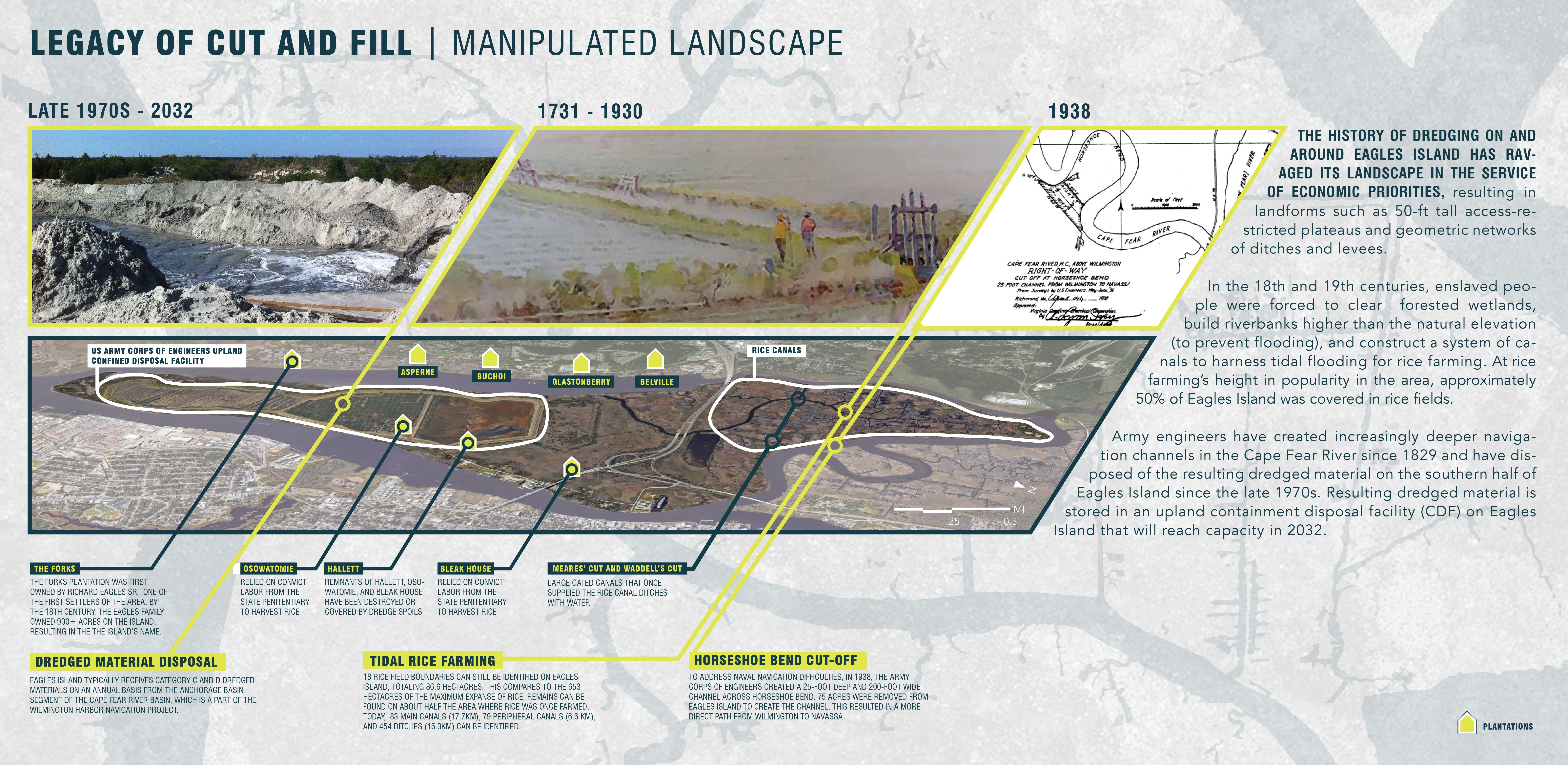
Dredging on and around Eagles Island in the service of agriculture, commerce, and transit has been achieved through both physical labor and mechanical means.
In the 18th and 19th centuries, enslaved people were forced to clear forested wetlands, build up riverbanks, and construct a system of canals to harness tidal flooding for rice farming. The land’s manipulated topography on the northern half of the island is a visual reminder of the relationship between human bondage and capitalism.
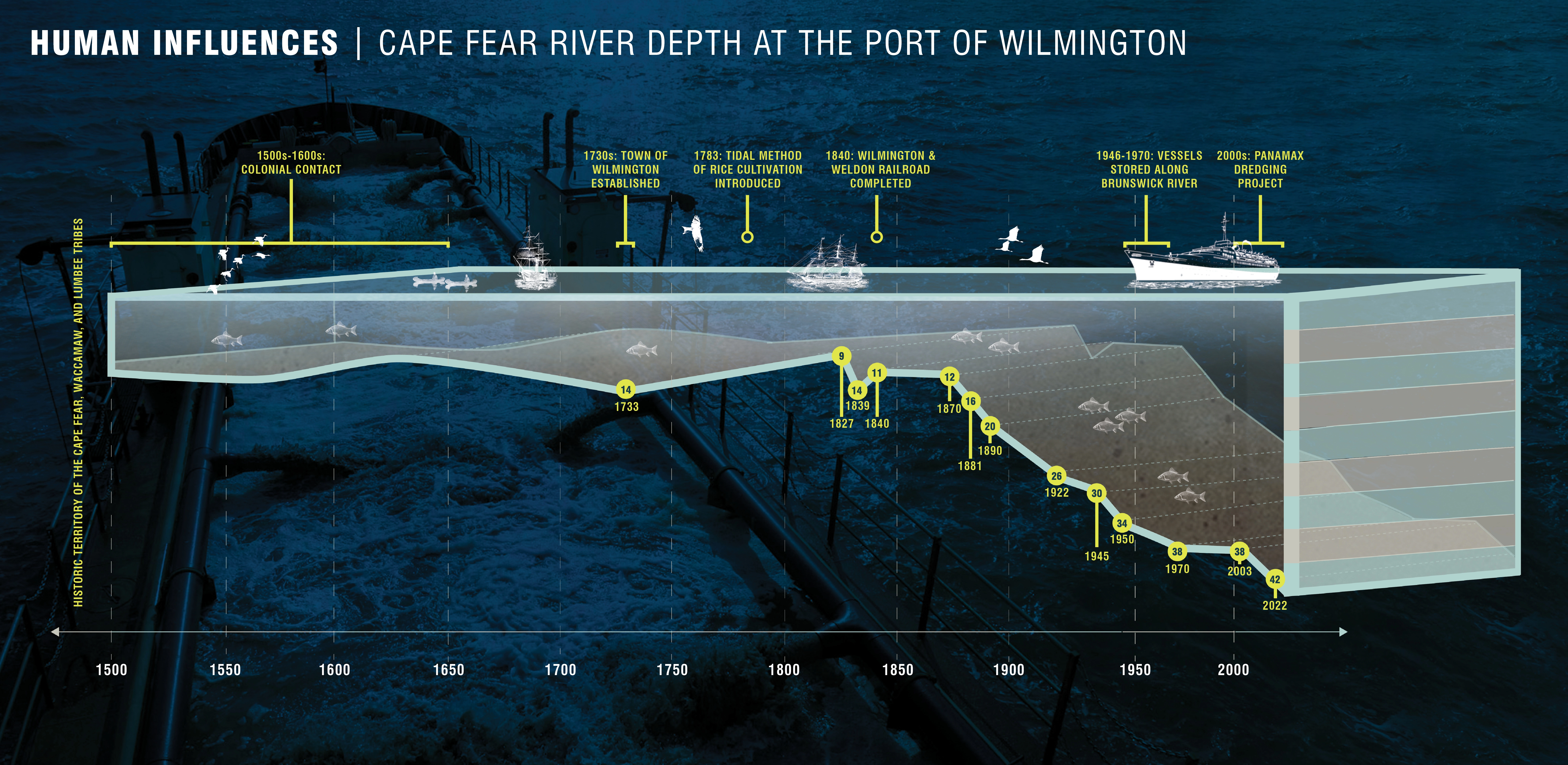
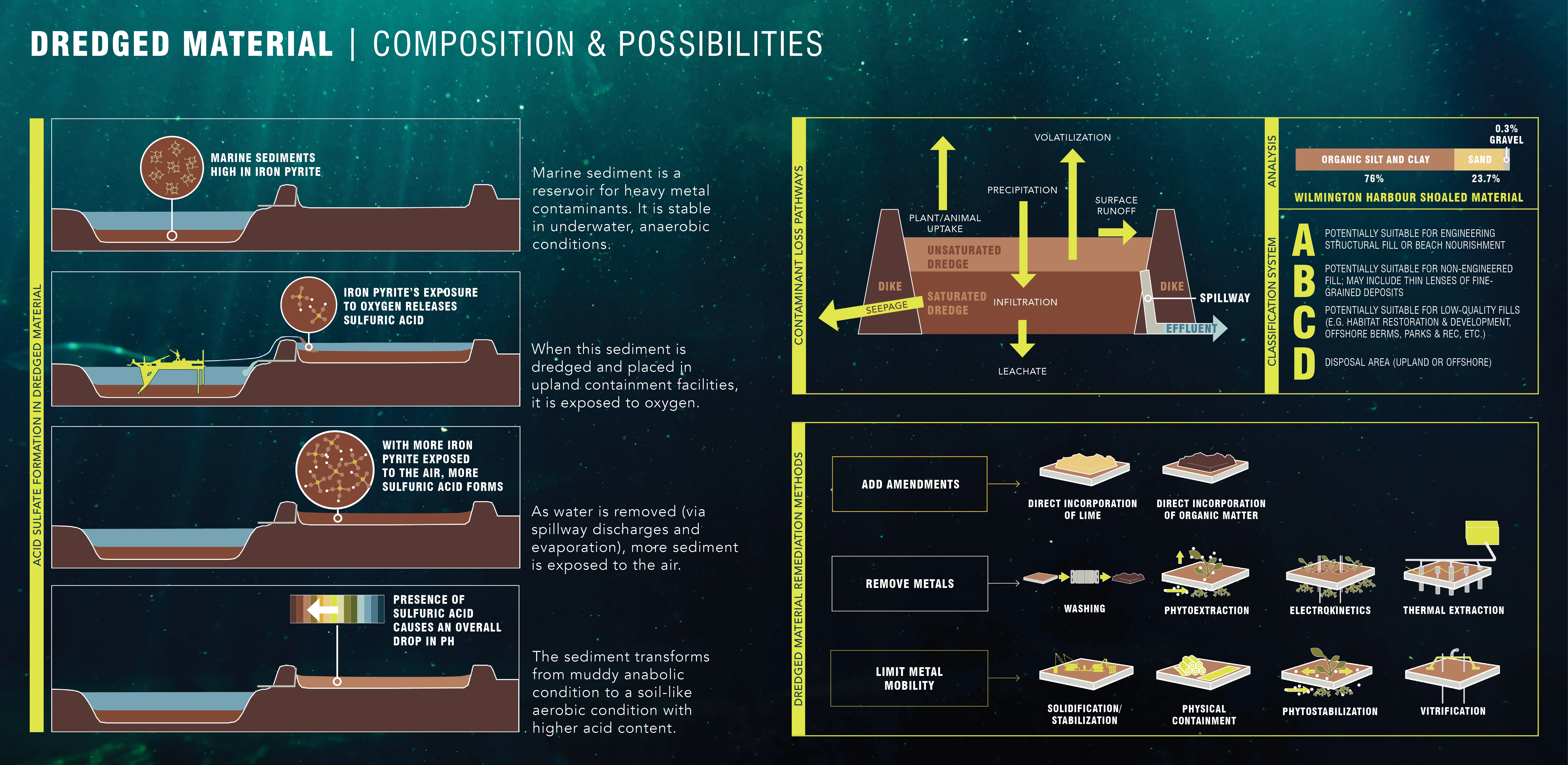
The island experienced dramatic changes when dredging became more efficient with mechanization. Army engineers have created increasingly deeper navigation channels in the Cape Fear River since 1829 and have disposed of the resulting dredged material on the southern half of Eagles Island since the late 1970s. Dredging of the harbor located on the Cape Fear River allows large ships to access the port directly to the east of Eagles Island. Resulting dredged material is stored in an upland containment disposal facility (CDF) on Eagles Island that will reach capacity in 2032.
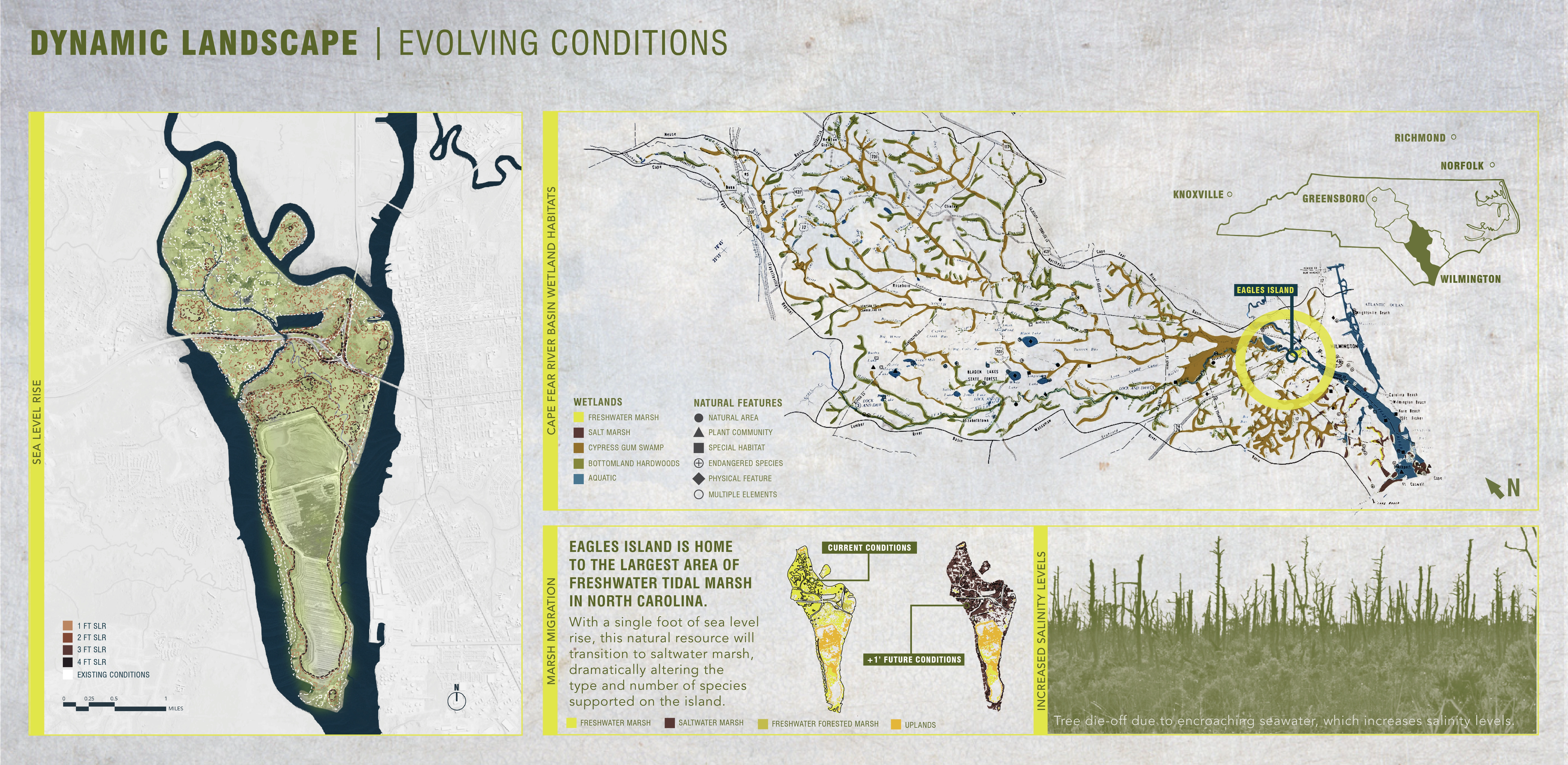
Climate Change and Evolving Conditions
While cut and fill has created landforms such as 50-ft tall access-restricted plateaus and geometric networks of ditches and levees, sea level rise (SLR) continues to alter the island’s footprint and ecological systems. On the northern part of the island, most of the elevation ranges between one and three feet above sea level. With increasing water and salinity levels, the process of marsh migration is already in progress. While SLR on the island is primarily due to climate change, dredging activity also contributes to the increased water levels. Human, mechanical, and climatic factors all contribute to the ever-evolving topography of the island.
Ecological and Cultural Significance
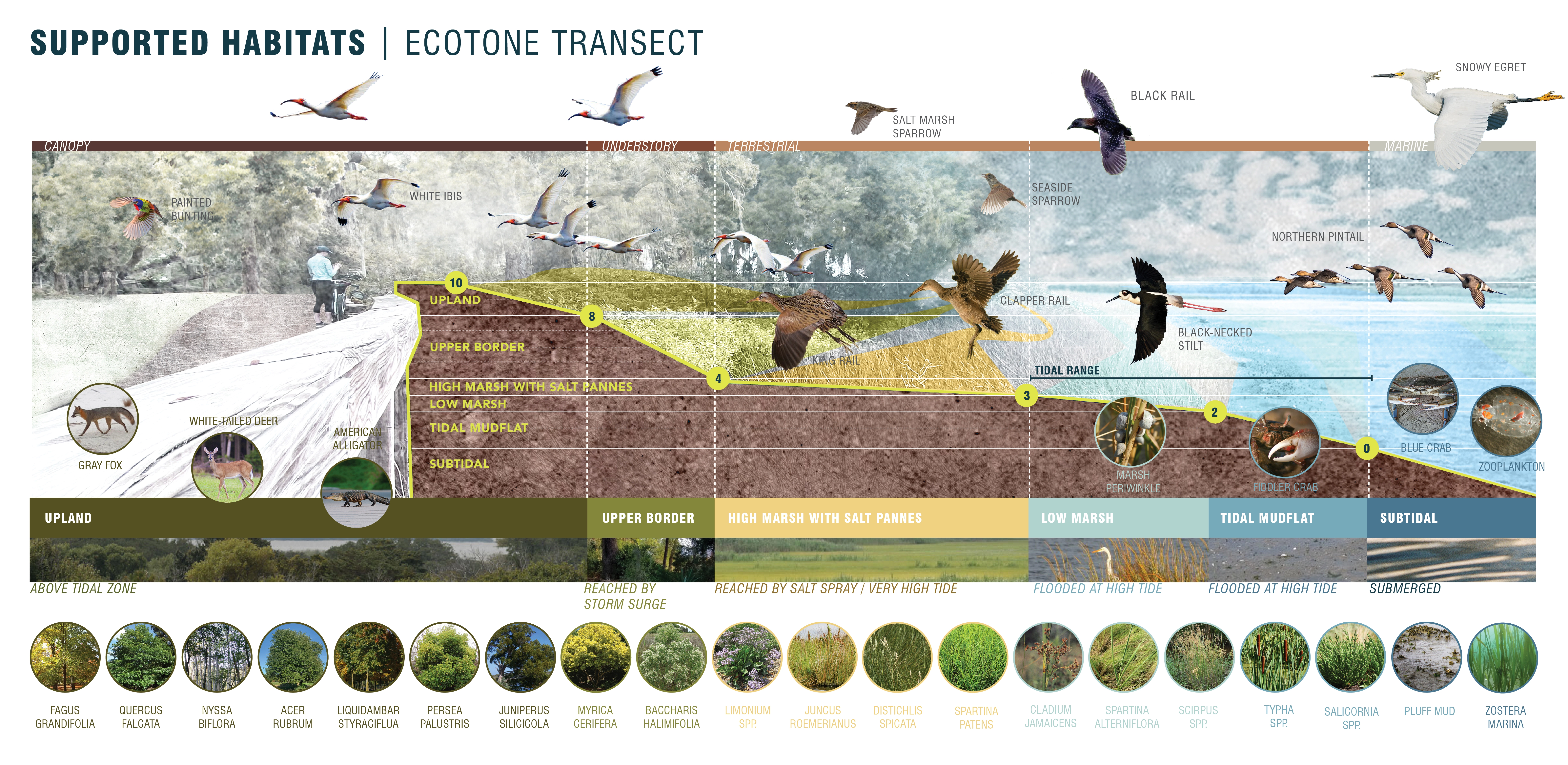
Even in a highly altered and bifurcated state, the island still features regionally notable ecological assets. The dredged material and surrounding brackish marsh create important habitat for a great number and variety of shorebirds, leading Audubon to designate the site as an Important Bird Area. The northern half of the island features the largest freshwater tidal marsh in North Carolina. The disappearing freshwater tidal marsh habitat provides a two-way buffer by protecting against flooding and SLR upstream, while also helping filter pollutants that come downstream from the rivers.
Conserving Eagles Island as a Nature Park
Hybrid Ecologies responds to a decades-long vision to conserve Eagles Island as a natural area. The northern half of the island is experiencing land loss because of SLR and dredging activity. The southern half of the island has an abundant resource of sediment in its nearly full upland CDF. This framework proposes unifying the northern and southern areas of the island in one comprehensive management plan that appeals to various community, government, and private stakeholders and dynamically adapts to the realities of climate change. Instead of half of Eagles Island lost to SLR and half restricted with an at-capacity CDF, the whole site could be in symbiotic relationship as a resilient landscape that balances economic and ecological priorities in a nature park.
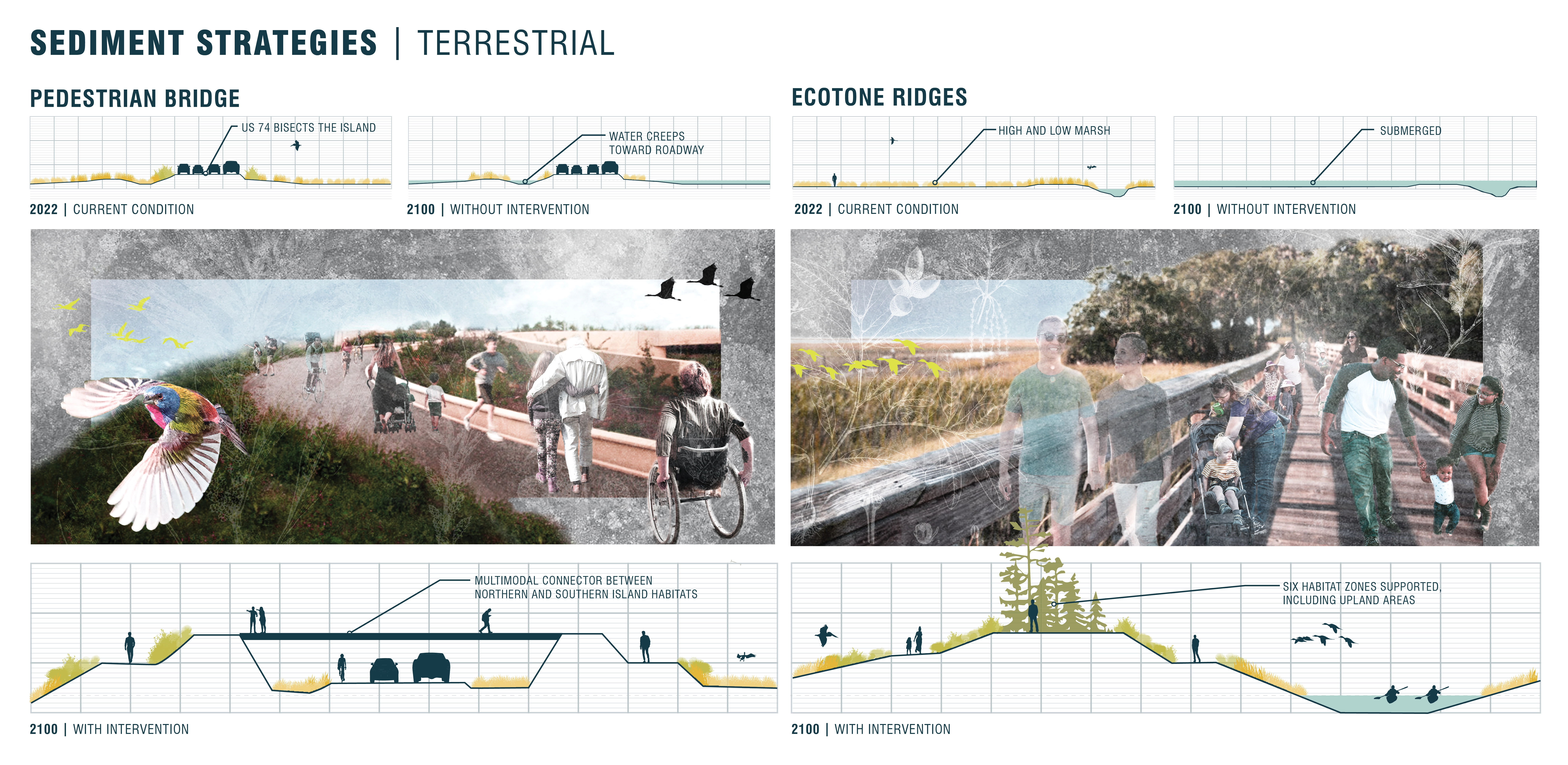
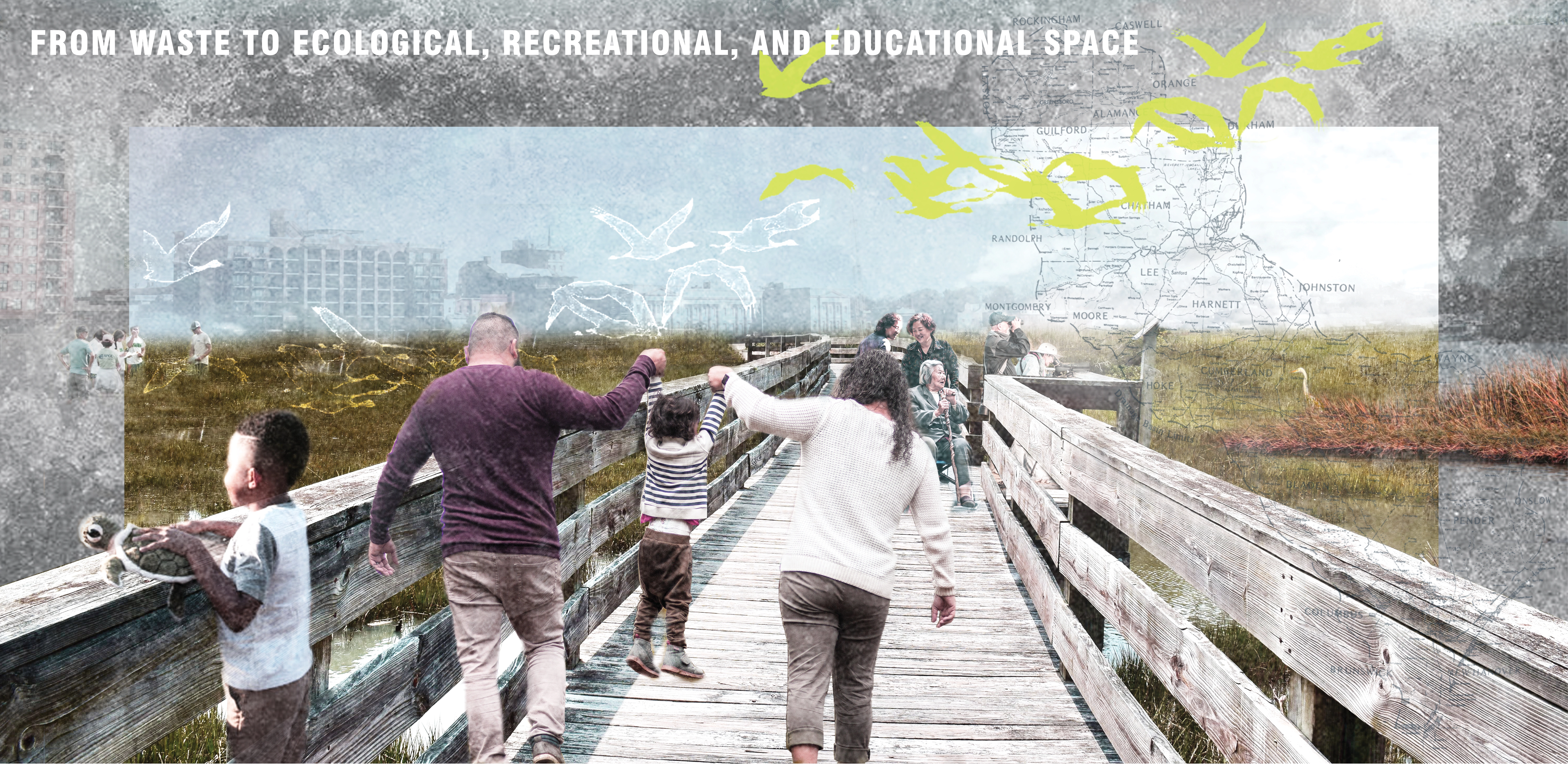
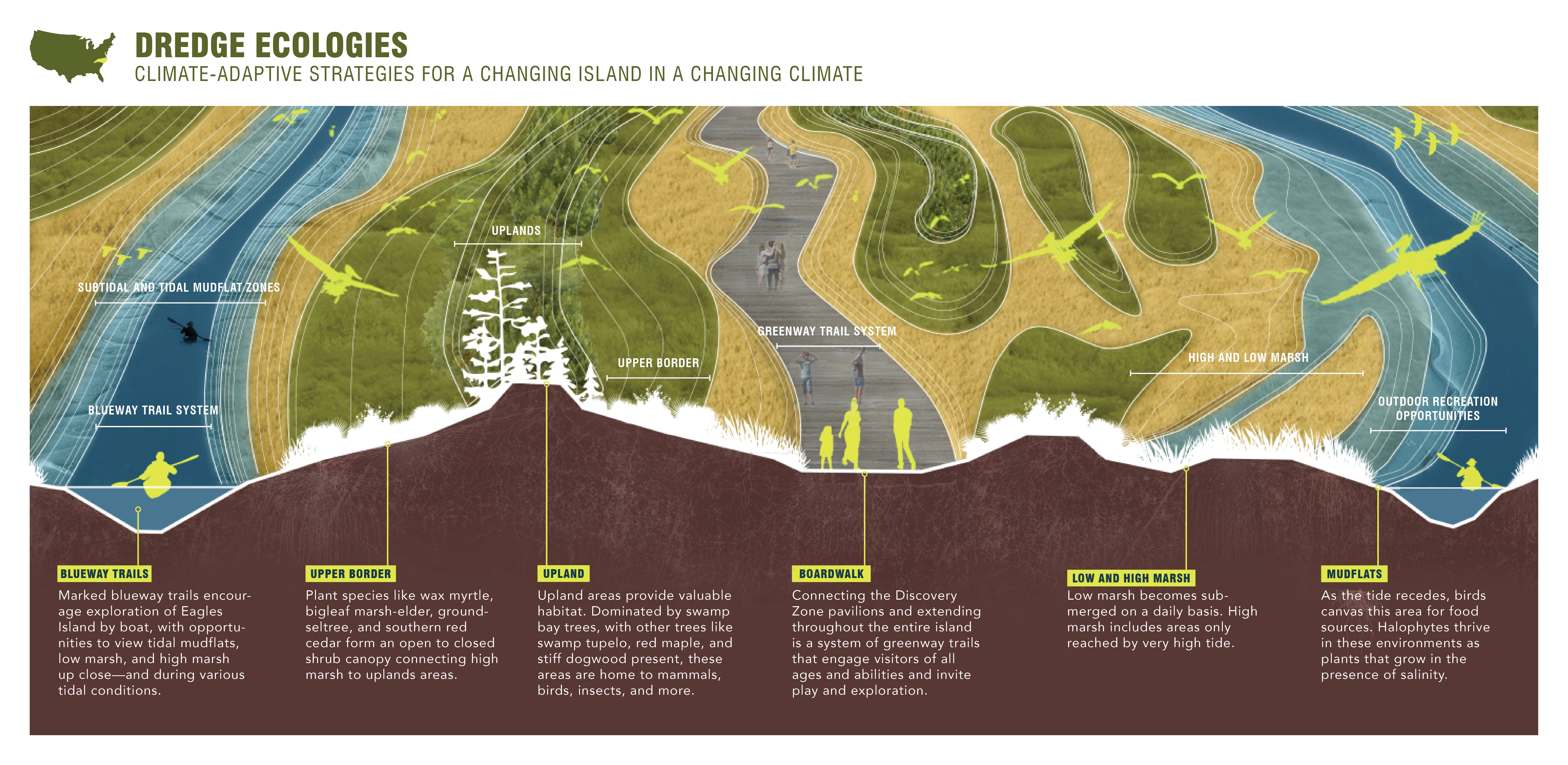
With climate change and SLR realities at the forefront, the project imagines that habitat constructed with remediated dredge could be made publicly accessible through a network of elevated boardwalks (greenways) and kayak trails (blueways). The nature park would provide space for an immersive marine and estuarine wetland experience, historical and cultural education about the island’s history and past inhabitants, and opportunities to witness the process of restoring critical coastal habitat.
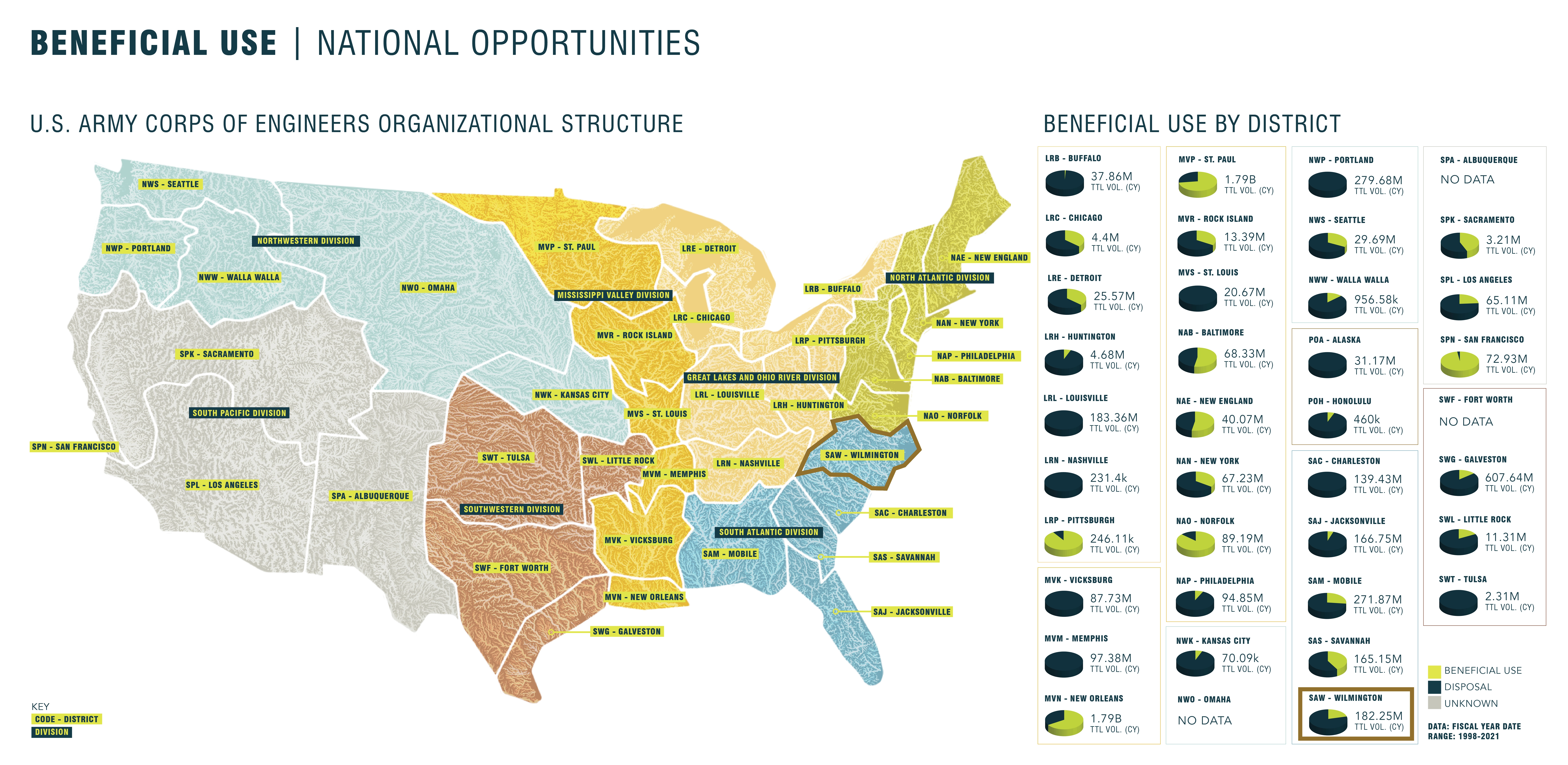
USACE and Eagles Island
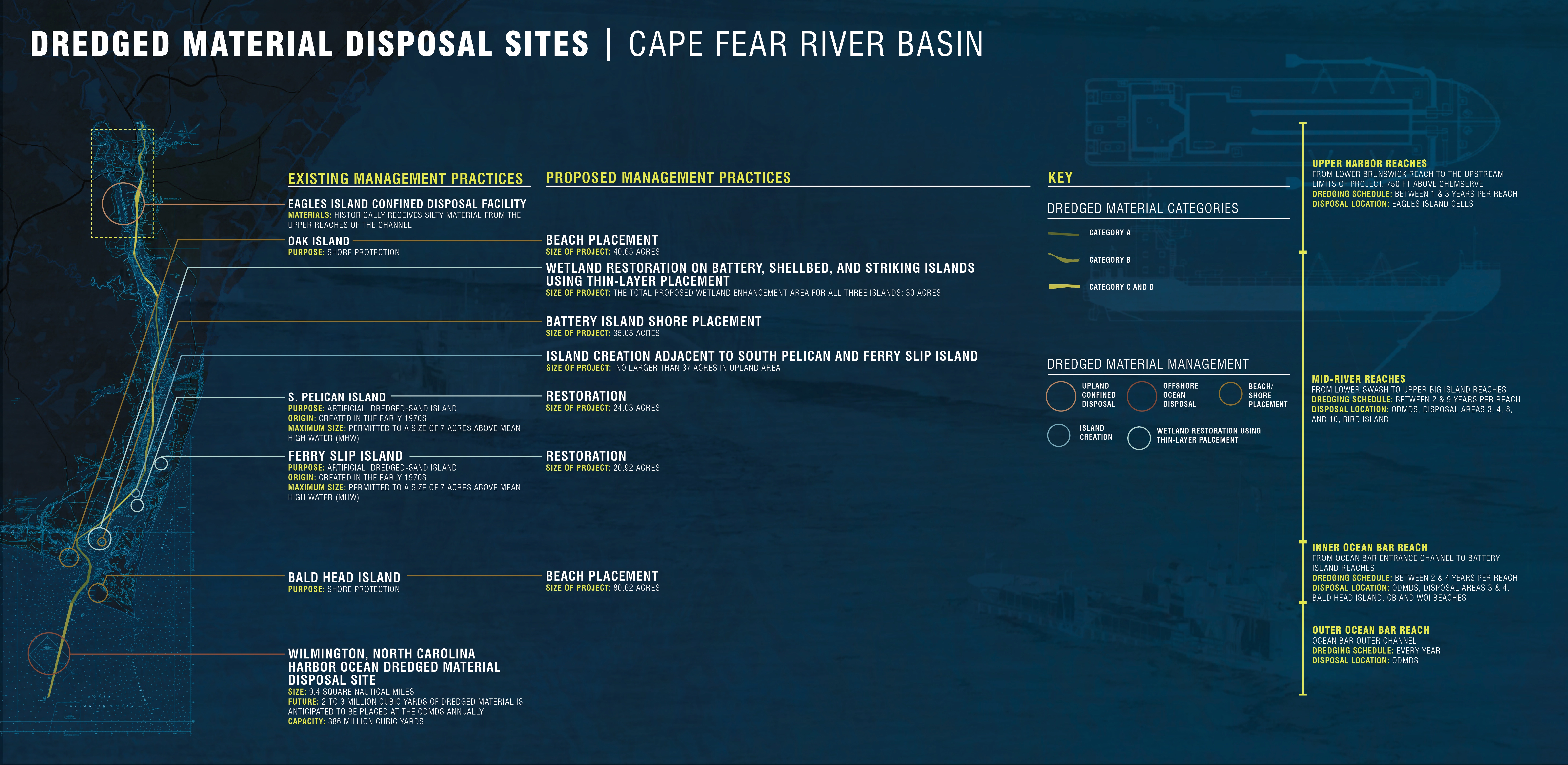
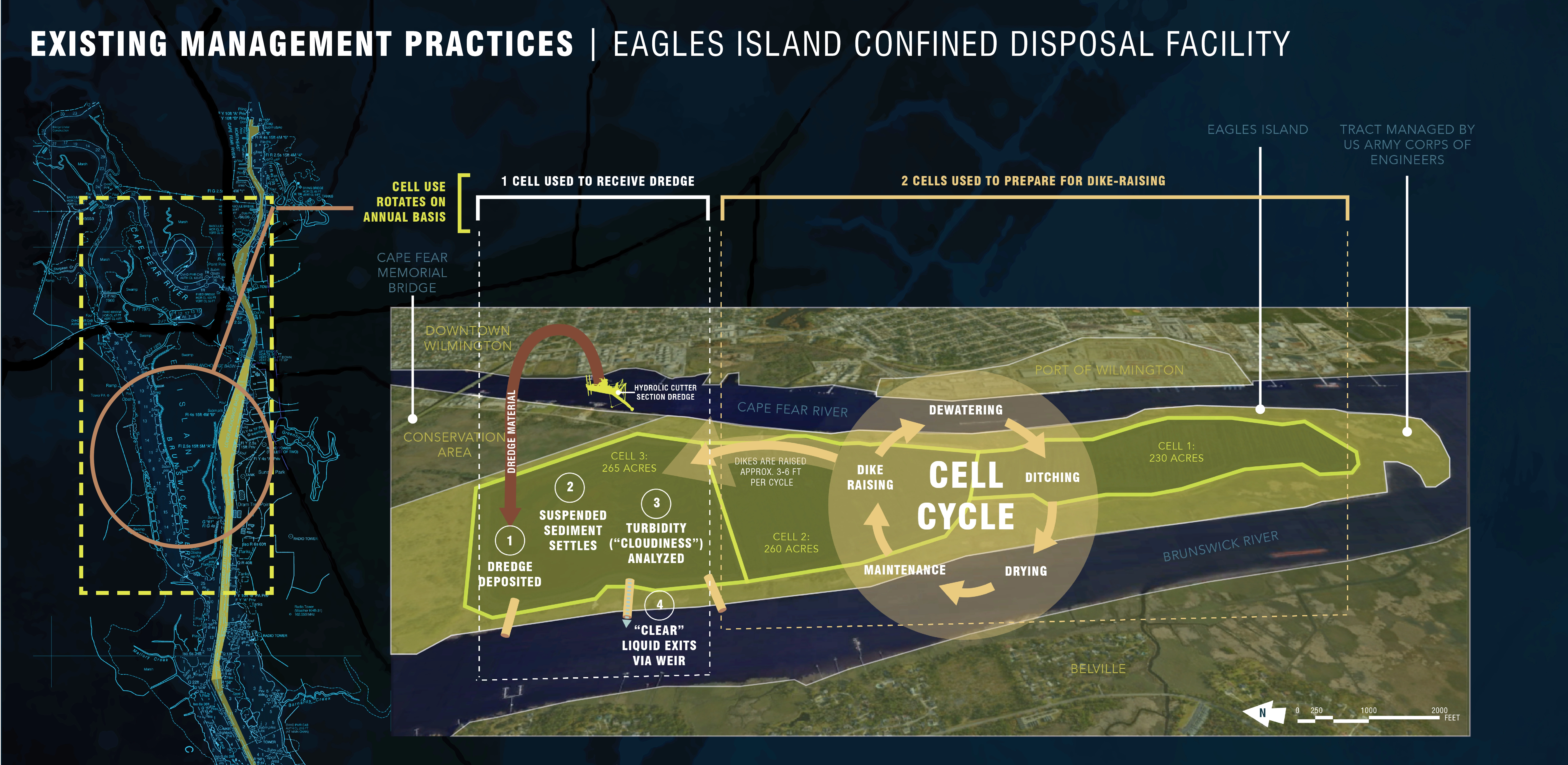
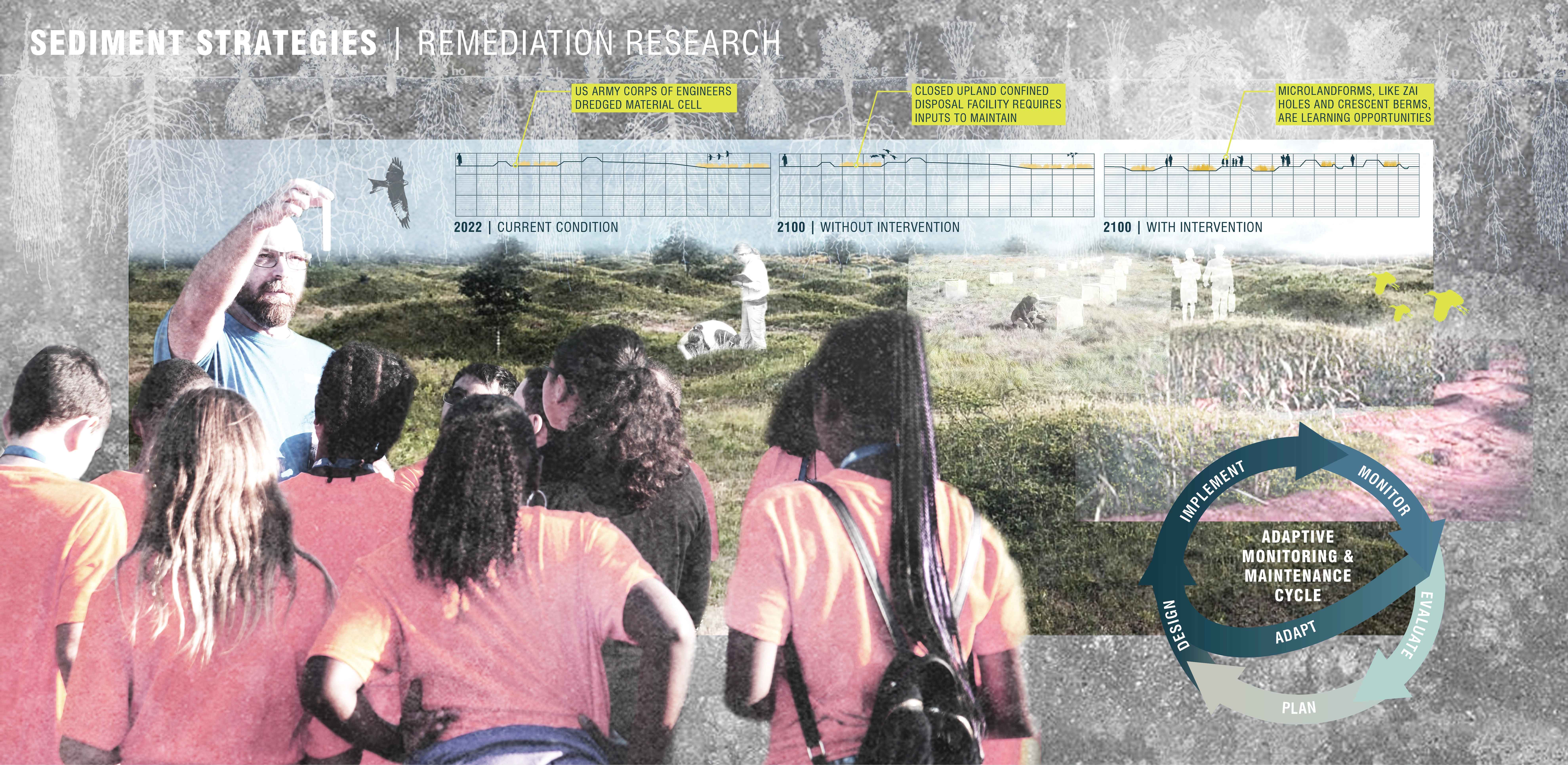
The U.S. Army Corps of Engineers (USACE) has been actively managing an upland CDF on Eagles Island since the late 1970s. A total of 755 acres of diked upland are contained within the three cells on the 1,473-acre tract. Each year, and on a rotating basis, one of these cells receives dredged material, while the other two go through a dewatering cycle. After dredged material is dewatered, the sediment is used to construct increasingly taller dikes so that the cells can hold even more dredge. When this area reaches capacity in 2032, the CDF will close, and all the dredged material that typically goes to Eagles Island will be shipped out to the Wilmington, North Carolina Harbor Ocean Dredged Material Disposal Site in the Atlantic Ocean.
Remediation Possibilities
The USACE contains dredged marine sediment in facilities like the one at Eagles Island because it has a high level of acidity that, without remediation, can be harmful to the environment. In an upland CDF, there are a variety of contaminant-loss pathways, posing a threat to the surrounding environment. A closed CDF requires perpetual inputs to manage the existing dredged material. With inaction resulting in a future condition of urban communities living adjacent to 755 acres of a potential environmental hazard, plans for alternative use of the site and its contents become more pressing. A literature review reveals that the three main dredged material remediation strategies are adding amendments, removing metals, and/or limiting metal mobility. The best and most cost-effective dredged material remediation techniques can be determined when an end goal for the sediment has been established.
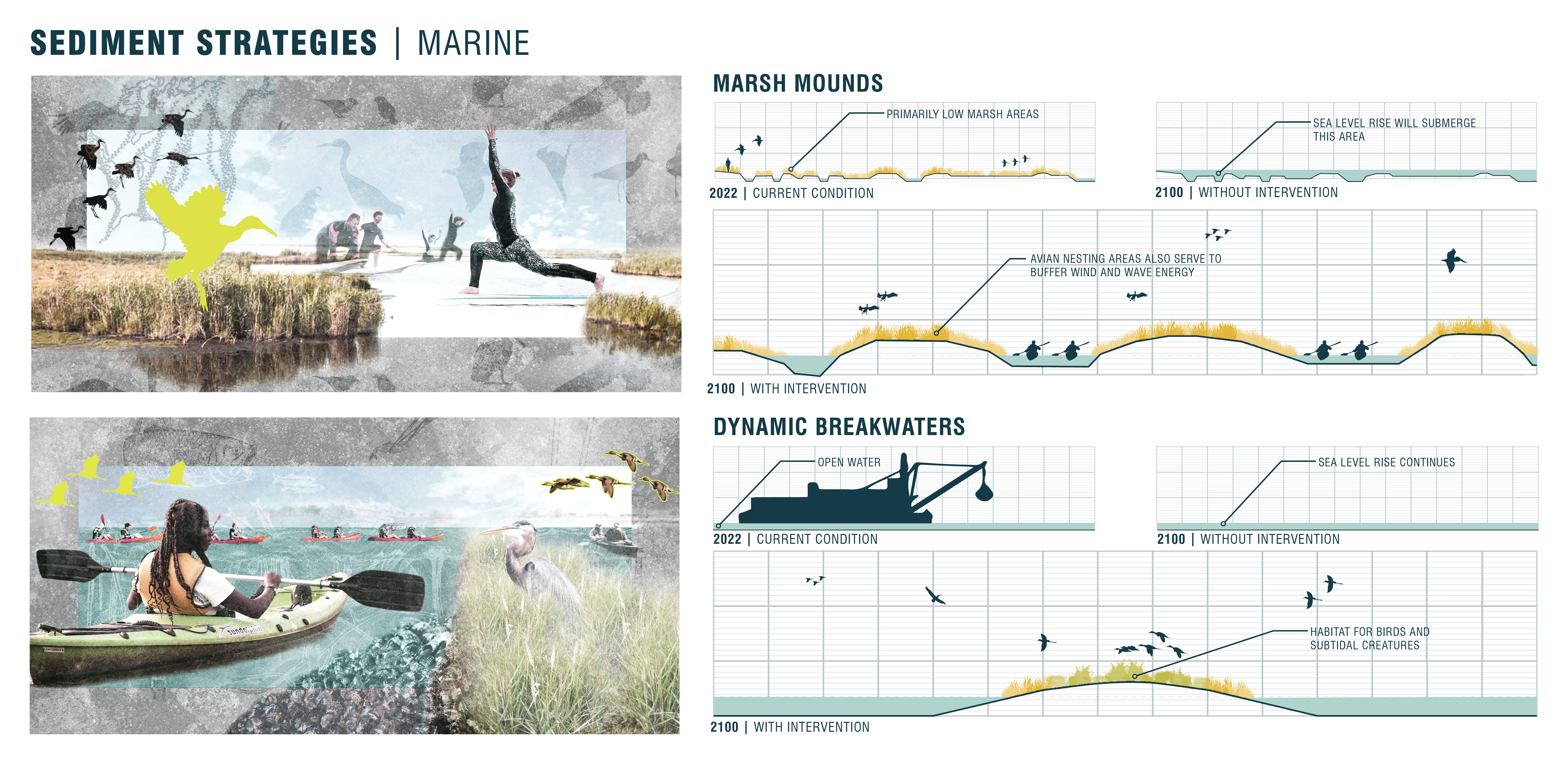
Sediment Strategies
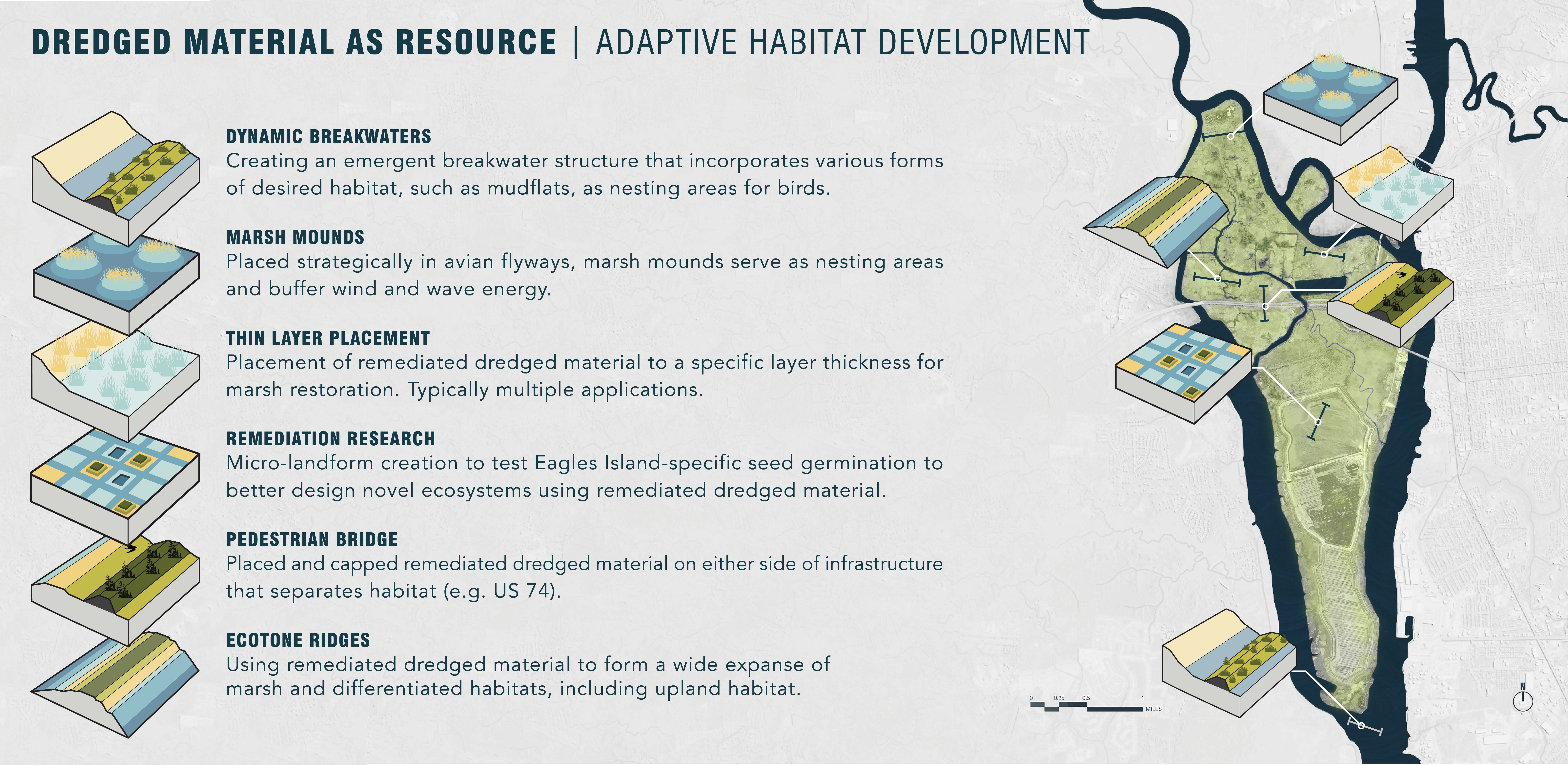
This framework proposes that the surrounding community use the sediment to its benefit. Preserving and creating as much land at various elevations in connected corridors would ensure higher levels of biodiversity are achieved. Sediment strategies considered for Eagles Island include dynamic breakwaters, thin layer placement, marsh mounds placed in avian flyways, remediation research, the construction of ecotone ridges, and using sediment to construct a pedestrian bridge. By envisioning dredged material as a resource for adaptive habitat development, ecologically diverse environments can be created and supported, transforming Eagles Island into a publicly accessible recreational and educational space.
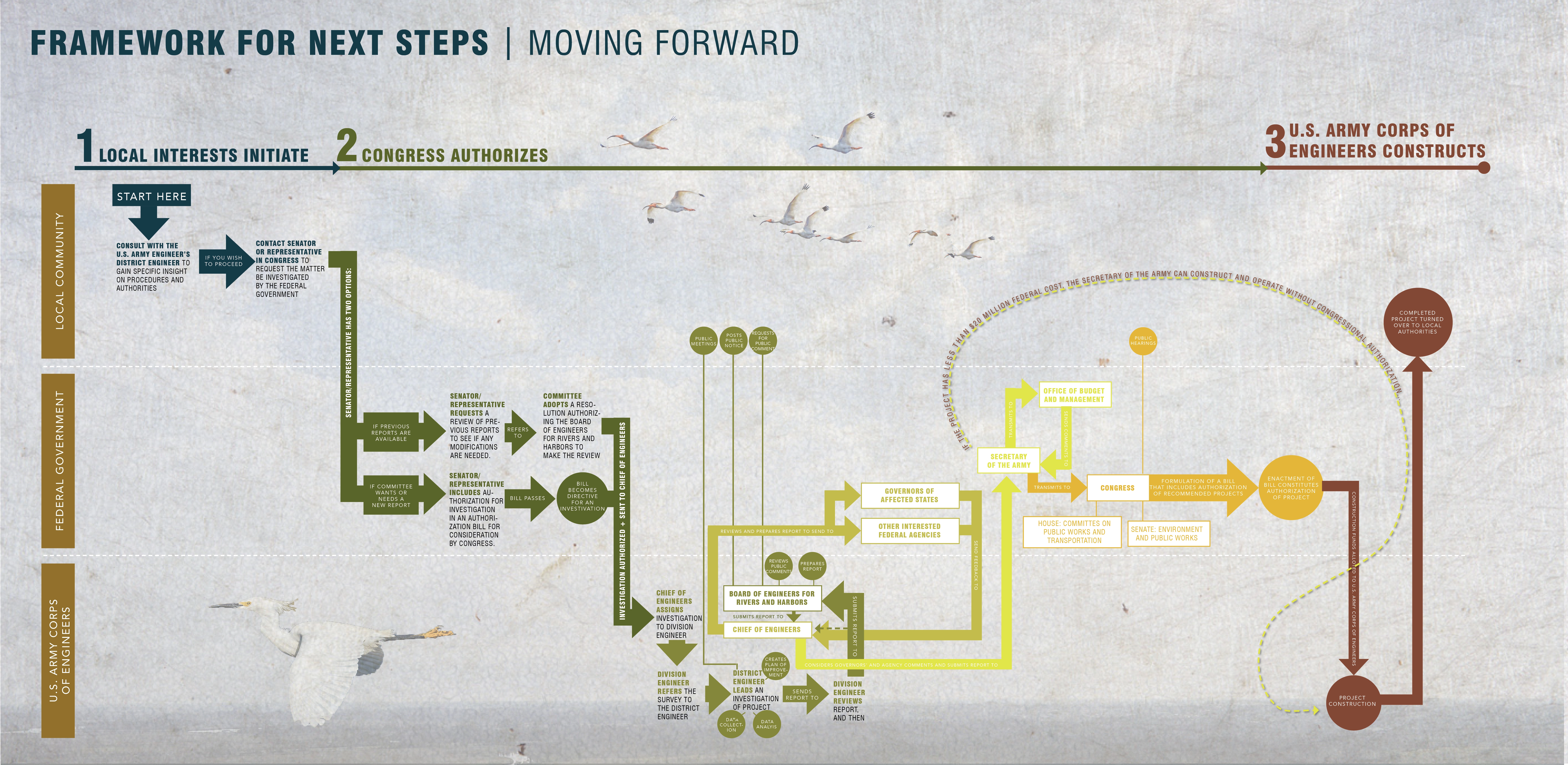
Engaging With Partners
Untangling a bureaucratic web and sifting out stakeholder roles is a complicated task for a volunteer community task force. Communicating to interested parties how the process of initiating and processing a USACE project unfolds is an important step toward making the vision a reality. This project clarifies the community’s role and equips them with key information to approach their state representative as a concrete action that can be taken to begin the process.
A Climate-Adaptive Example for the Beneficial Reuse of Dredged Materials
Hybrid Ecologies is an example of a replicable analysis and planning framework for reimagining the fate of closed upland CDFs and their contents near growing urban areas. In the US, over 200 million cubic yards of material is dredged annually from the bottom of federally constructed and maintained navigation channels. About 10-15% of dredged material requires special handling (USACE Beneficial Use), while the remaining 85% is available for beneficial use. Of this available sediment, approximately 38% is currently used to deliver environmental, economic, and social benefits (USACE RSM Tool). This leaves approximately 135.4 million cubic yards of available, yet discarded, dredged material. This project challenges landscape architects to consider their responsibility to explore sediment sourcing alternatives for public and private projects across the country.
A Balanced Approach
Like many coastal environments, Eagles Island is not a pristine and untouched island; rather, it has been significantly manipulated for centuries–and it will continue to be shaped by climate change. Hybrid Ecologies proposes yet another human alteration of the island to further shape its direction, but in the service of community and environmental health. By engaging with dredged material and bringing together decision-makers facing climate-based challenges, this project illuminates landscape architects’ role in visualizing resilient, site-specific design solutions.
Advertisement
Related Awards

Honor Award, Analysis & Planning
A Cultural Approach: The Fort Peck Tribes Hazard Mitigation Plan
In collaboration with the Fort Peck Assiniboine and Sioux Tribes, EPA, and FEMA, the Fort Peck Tribes Hazard Mitigation Plan (HMP) adopts a culturally responsive approach to hazard mitigation planning that features connection to place.

