.webp?language=en-US)


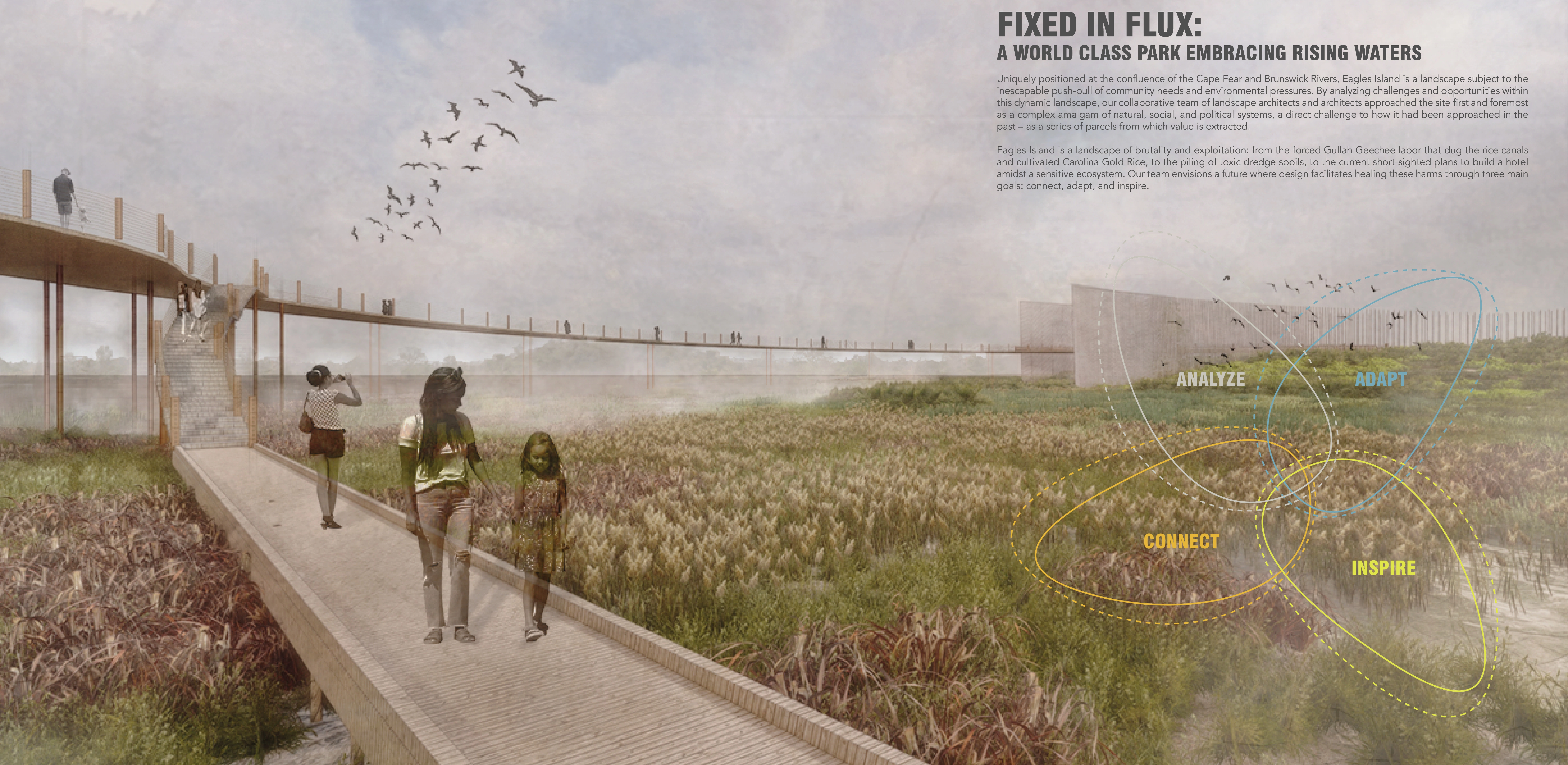
Fixed In Flux: A World Class Park Embracing Rising Waters
Brian Vaughn, Student ASLA; Lauren Joca, Student ASLA; Makayla Esposito, Student ASLA; Davis Turner, Student ASLA; Hassan Shata, Student ASLA
This project maximizes the expertise of landscape architects and architects in a collaborative effort that balances human placemaking and ecological systems.
Awards Jury
-
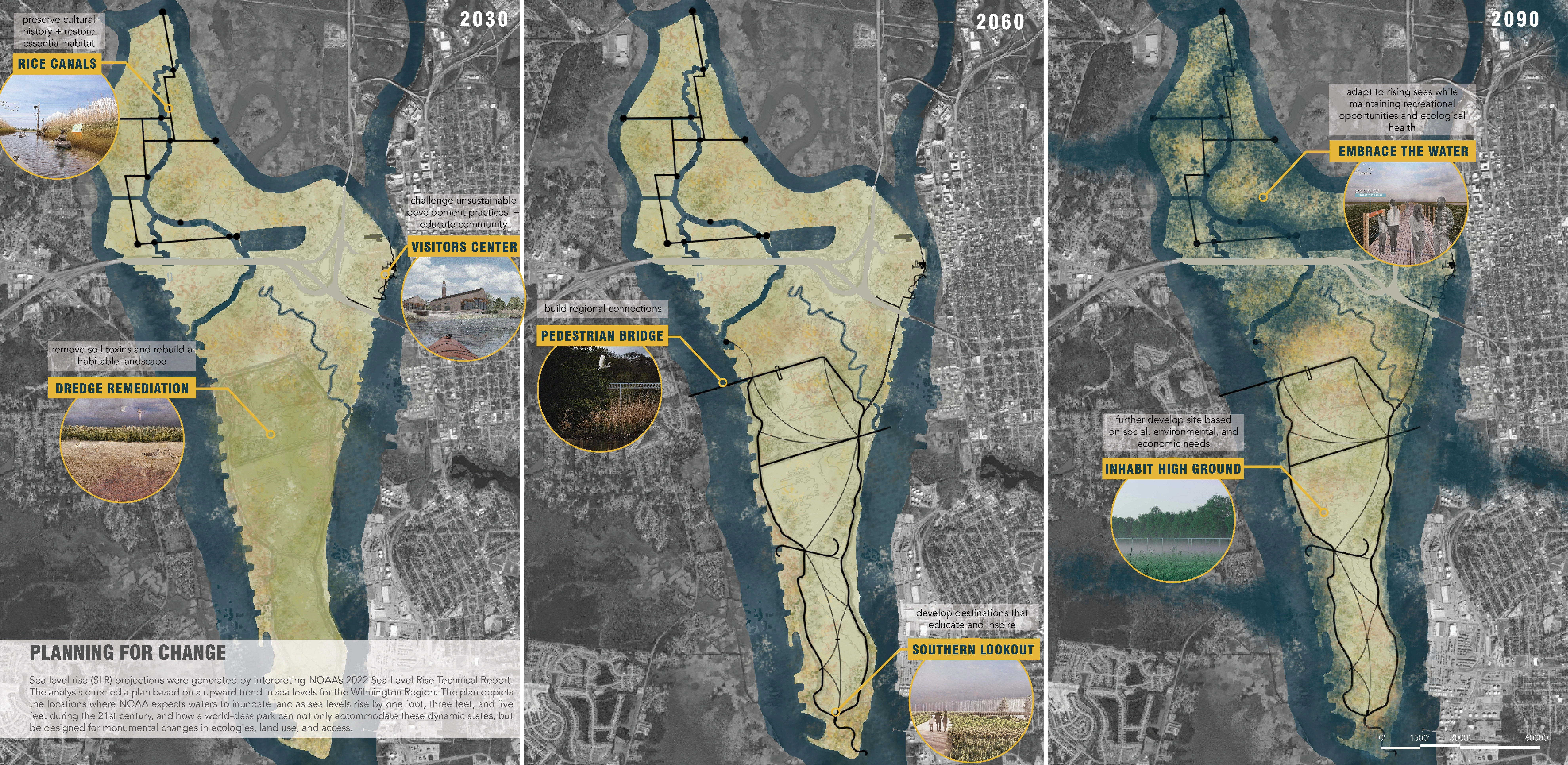
Eagles Island, an ecologically vital freshwater marsh, has been continually altered through processes of extraction and deposit. This landscape, directly adjacent to Wilmington, North Carolina and between two of the state’s fastest growing counties, presents a generational opportunity for community stakeholders. Developed through informed and multiscalar analysis, Fixed in Flux proposes a ecologically distinct and regionally significant park that anticipates adaptation to dynamic natural forces through the next century and beyond.
This project contends with pressing soceital issues: reconciling brutal histories of rice extraction by enslaved people, unsustainable status-quo coastal development, and rising waters caused by a changing climate. Informed through robust land suitability analysis, the project proposes a riverfront Visitors' Center on the limited high ground. Additionally, the project reimagines an existing 25 foot-tall earthen berm that contains dredge spoils as an amenity for recreation and circulation–linking thousands of surrounding residents to the park across two rivers. Fixed In Flux reconciles the contemporary challenges of sea level rise and unsustainable development, countering extractive attitudes towards coastal ecologies with park that countless generations will cherish.
-
HISTORY & CONTEXT
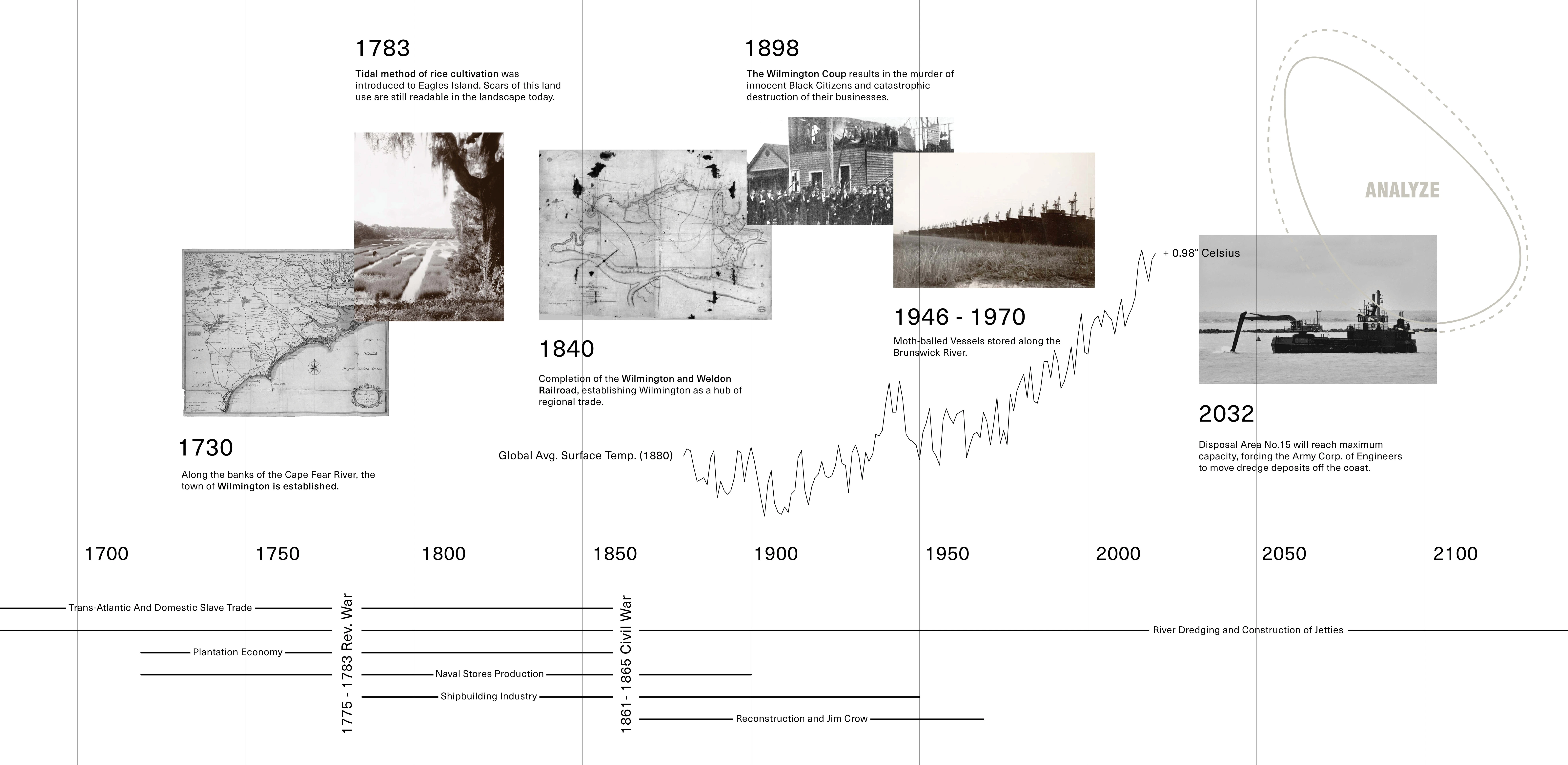
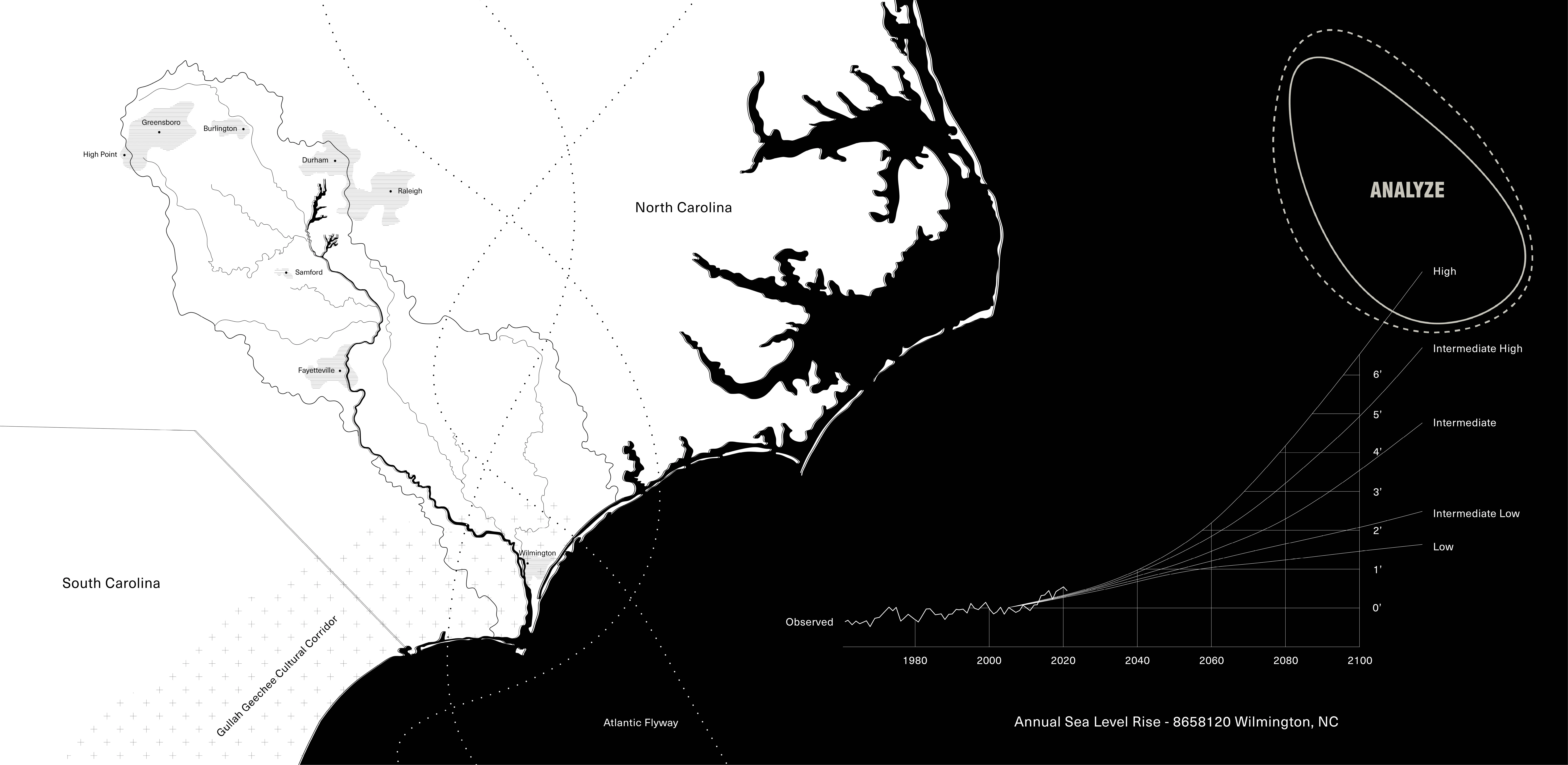
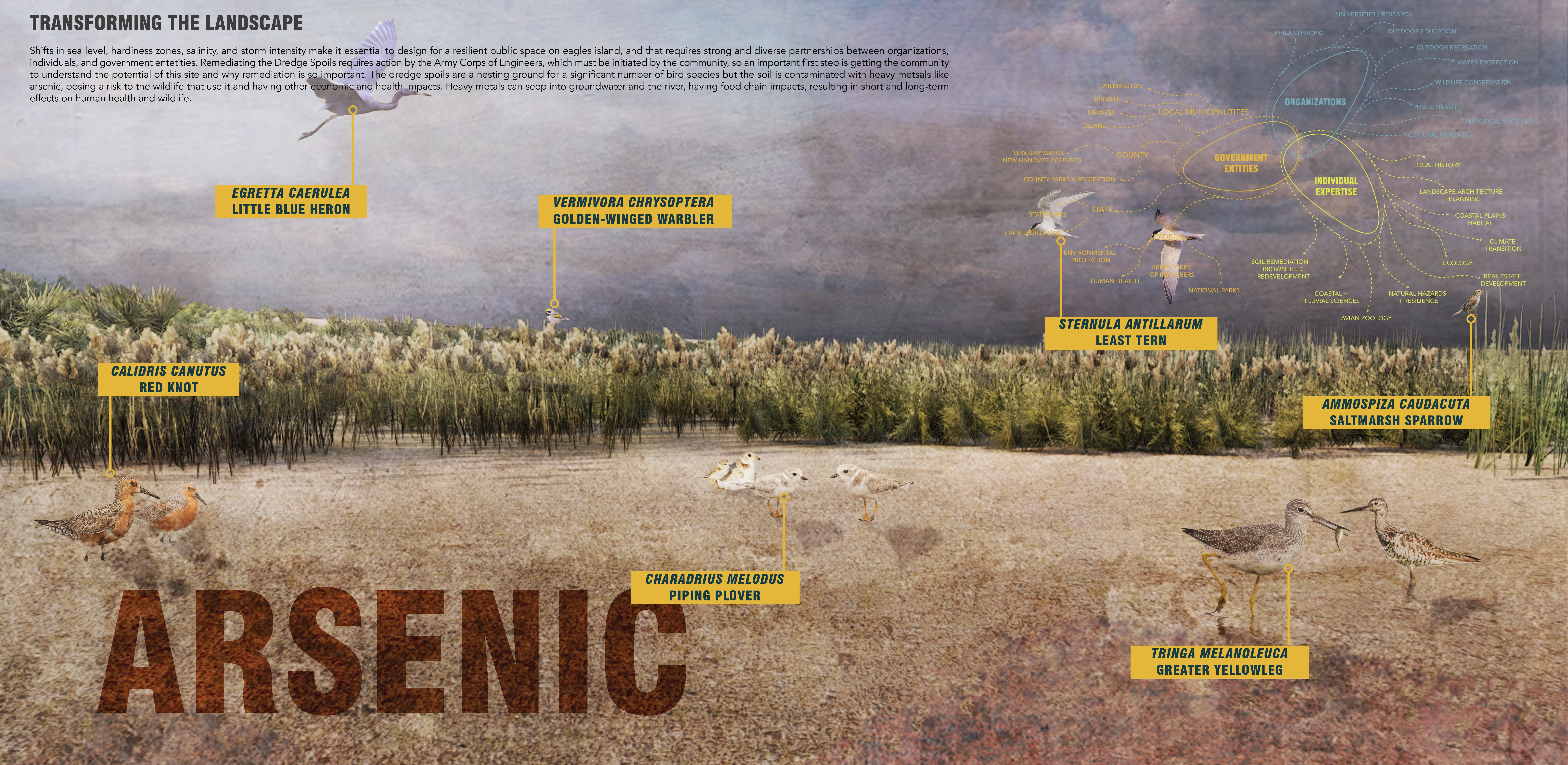
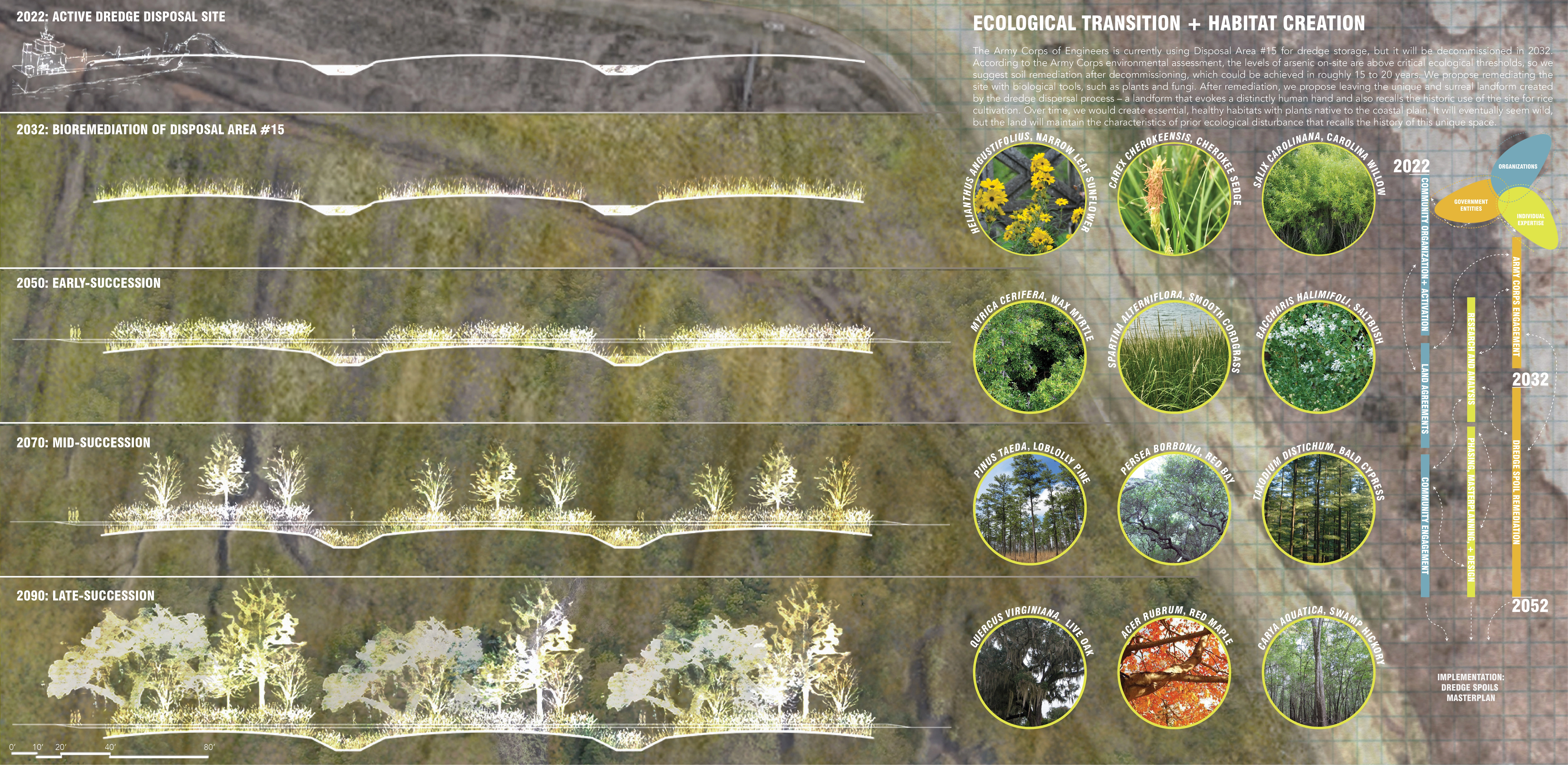
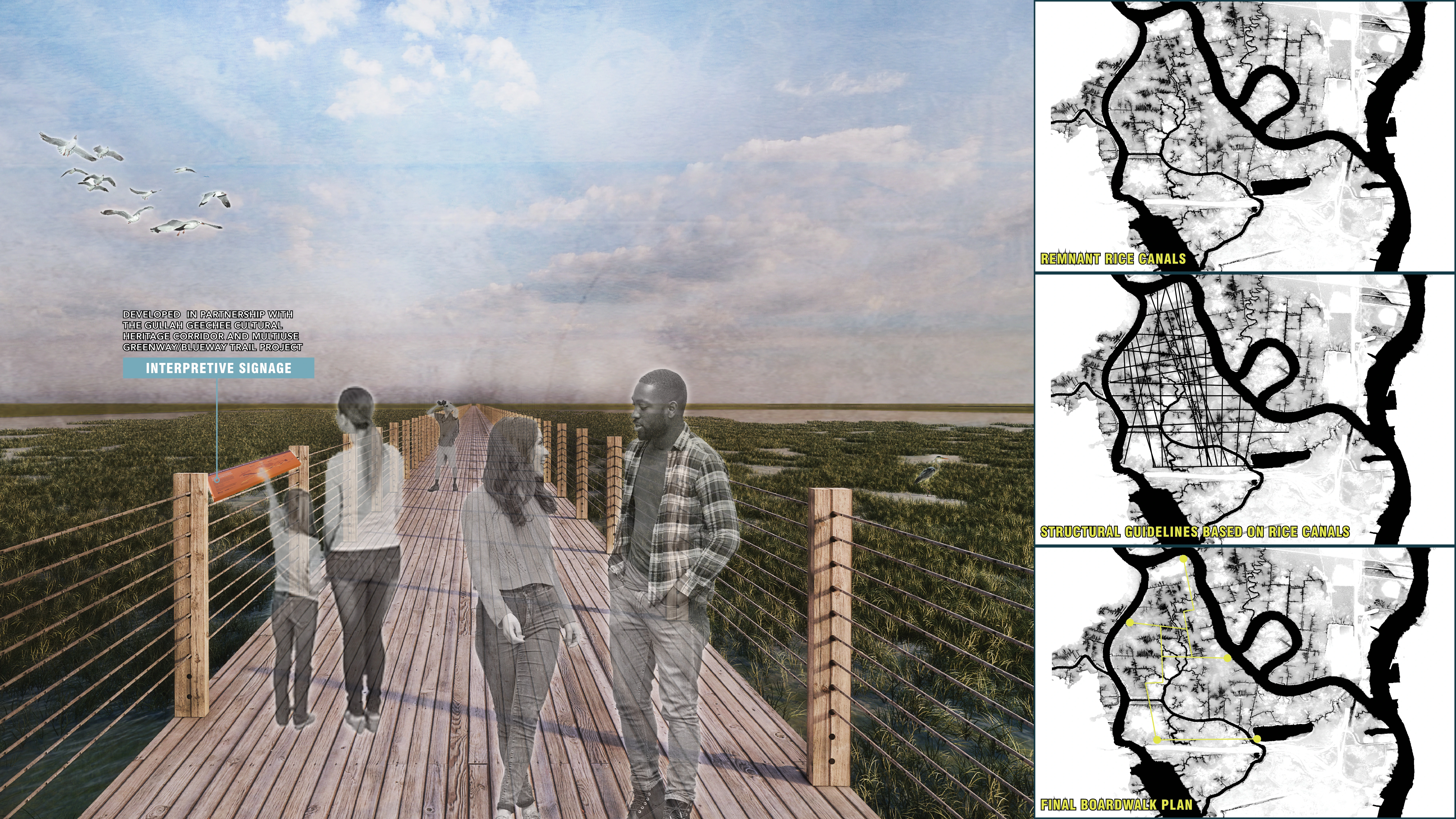
Eagles Island sits at the confluence of the Cape Fear and Brunswick rivers in Wilmington, North Carolina, a coastal city with a growing population known for its historic charm and nearby access to pristine beaches. The northern end of the site retains the scars of remnant rice canals that were once part of a rice plantation, constructed and cultivated by enslaved Gullah Geechee peoples. A proposed regional Gullah Geechee Heritage Trail will link local culturally historic sites in Navassaand Southport, NC, with the potential to link to the historic rice canals of Eagles Island through blueway and greenway trails. The southern end of the site is currently being used to store dredge spoils from the Cape Fear river, but is set for decommissioning in 2032. Surrounded by an earthen berm 24 feet above the surrounding sea level, it is a surreal wasteland. Its toxic soils and unique landform reveal the heavy hand of humans in shaping our world and natural systems – an embodiment of the anthropocene.
SITE ANALYSIS
As a collaborative team of landscape architects and architects, we agreed to approach the site first and foremost as a complex amalgam of natural, social, and political systems, a direct challenge to how it had been approached in the past – as a series of parcels from which value is extracted. In taking this approach, we examined and analyzed many layers of environmental, social, cultural, and economic data.
One of the most significant drivers of change at Eagles Island is sea-level rise. The latest NOAA projections published in February 2022 indicate that sea level will rise at least one foot by 2050, regardless of interventions to lower greenhouse gas emissions. By using NOAA marsh migration maps, we gained a better understanding of what the future conditions might look like on Eagles Island – how the current tidal freshwater marsh will transition to saltmarsh and later to unconsolidated shore. Shifts in USDA hardiness zones and salinity indicate future shifts in habitat range for flora and fauna, and analyzing these shifts inspired our multi-generational approach to the site.
Analyzing extant habitat and vegetation revealed that Eagles Island is the largest area of tidal freshwater marsh habitat in North Carolina. This ecosystem serves as an important nursery for spawning aquatic and marine species. Much of the site also provides critical breeding, migratory, and all-season habitat for a number of bird species, and the dredge spoils area has been designated as a global-priority Audubon Important Bird Area (IBA). The dredge spoils, slated for decommissioning in 2032, are contaminated with heavy metals such as arsenic, posing a risk to the wildlife that use it and having other economic and human health impacts. Zooming out and examining the island’s position within the larger Cape Fear watershed revealed the likely reasons for the polluted spoils: the watershed is home to nearly a third of North Carolina’s population, is heavily industrialized, and receives runoff from a significant amount of farmland.
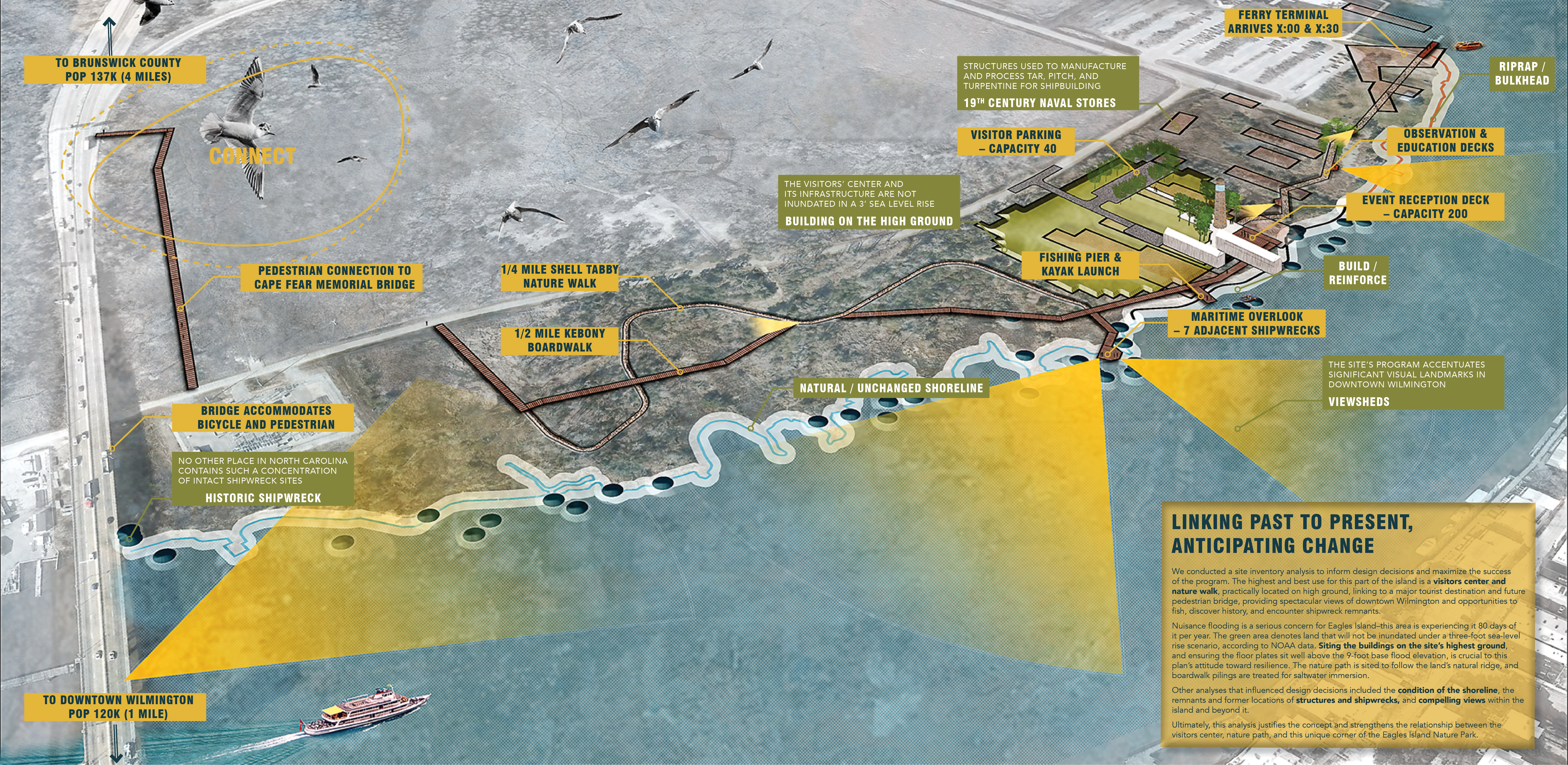
Eagles Island has suffered collateral damage for economic development in the Wilmington region since colonial times. By using archival maps of the area, we determined the location of historic rice canals, former naval stores and shipbuilding operations, and more recent dredge disposal, which all informed proposed plans for the site. We studied projected economic pressures on the island through examining regional and national population trends and census projections.
Census information, combined with analysis of existing pedestrian and bike connectivity through Strava data, and mapping regional green space with ArcGIS, revealed major gaps in access to green space as well as existing bike/pedestrian infrastructure. This analysis highlighted the essential role of Eagles Island in connecting disparate communities through recreational amenities.
COMMUNITY ENGAGEMENT
Three key members of the Eagles Island Task Force served as representatives for the community. Stakeholders presented on the island's history and context, what they saw to be opportunities and constraints, and the community’s overarching vision for the site: a world class “central park” for the Wilmington metro area that facilitates conservation, education, and recreation. Throughout the semester, we presented analysis and designs to these stakeholders, and received feedback that we incorporated into further iterations.
APPROACH
Stakeholders seek a park that supports regional connection, stewards a healthy ecosystem, and celebrates Gullah Geechee culture. Our interdisciplinary team realized that a truly resilient design must also embrace the dynamism of Eagles Island. The island’s rich history has seen the land shaped for human use, but its ecological character is also rooted in change as a tidal freshwater marsh. From daily fluctuations in water level to large scale alterations in landform, the only constant on Eagles Island is change. It is a place that is fixed in flux. By structuring our overall design in broad phases, providing some site-specific approaches, and not shying away from the difficult truth of a changing climate, we are striving to be agile and flexible, embracing change and facilitating positive transformation.
Eagles Island is a landscape of brutality and exploitation: from the forced Gullah Geechee labor that dug the rice canals and cultivated Carolina Gold Rice, to the piling of toxic dredge spoils, to the current short-sighted plans to build a hotel amidst a sensitive ecosystem. But this landscape is also one of possibility. Our team envisions a future where design facilitates healing these harms through three main goals: connect, adapt, and inspire.
CONNECT
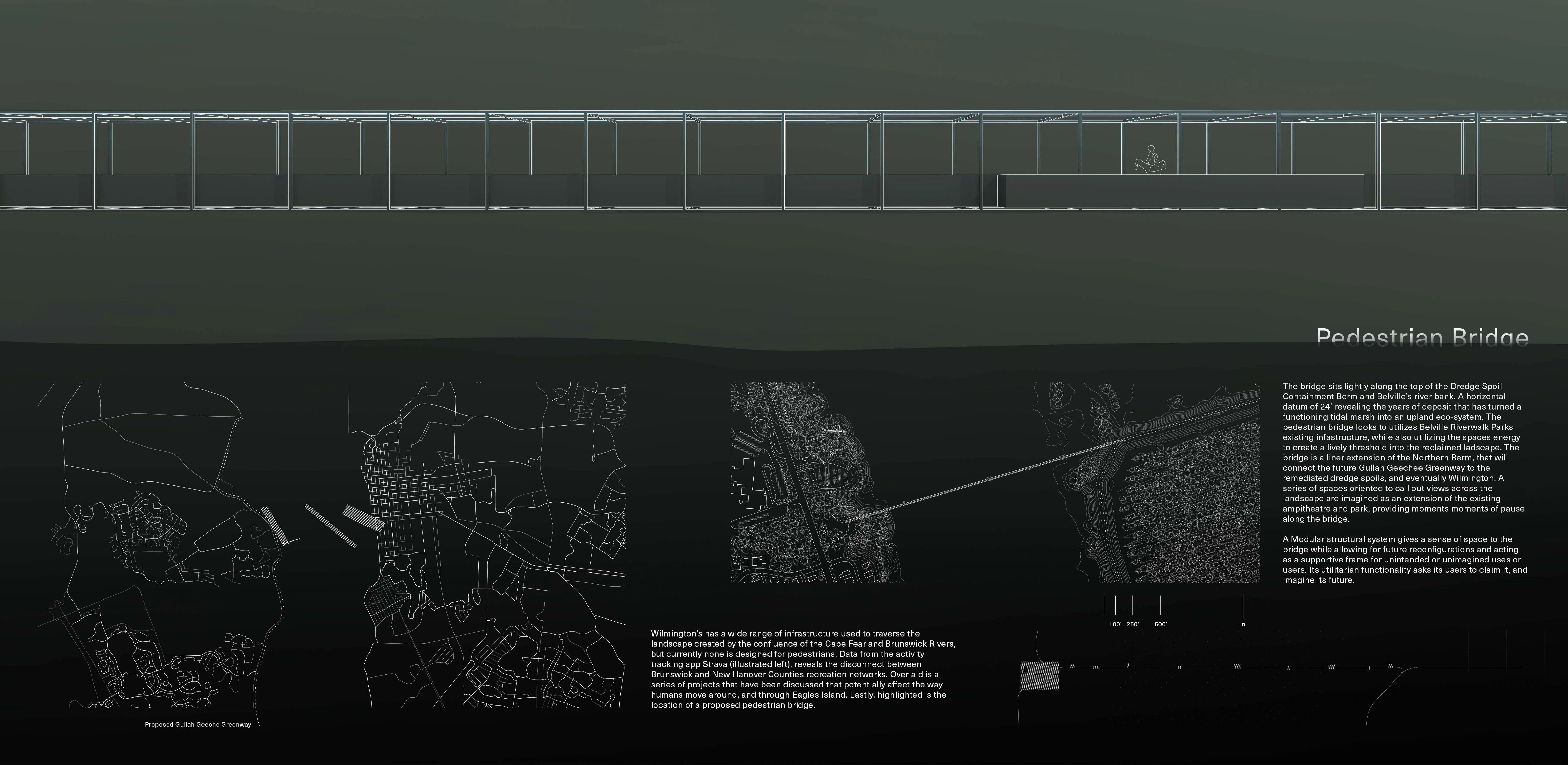
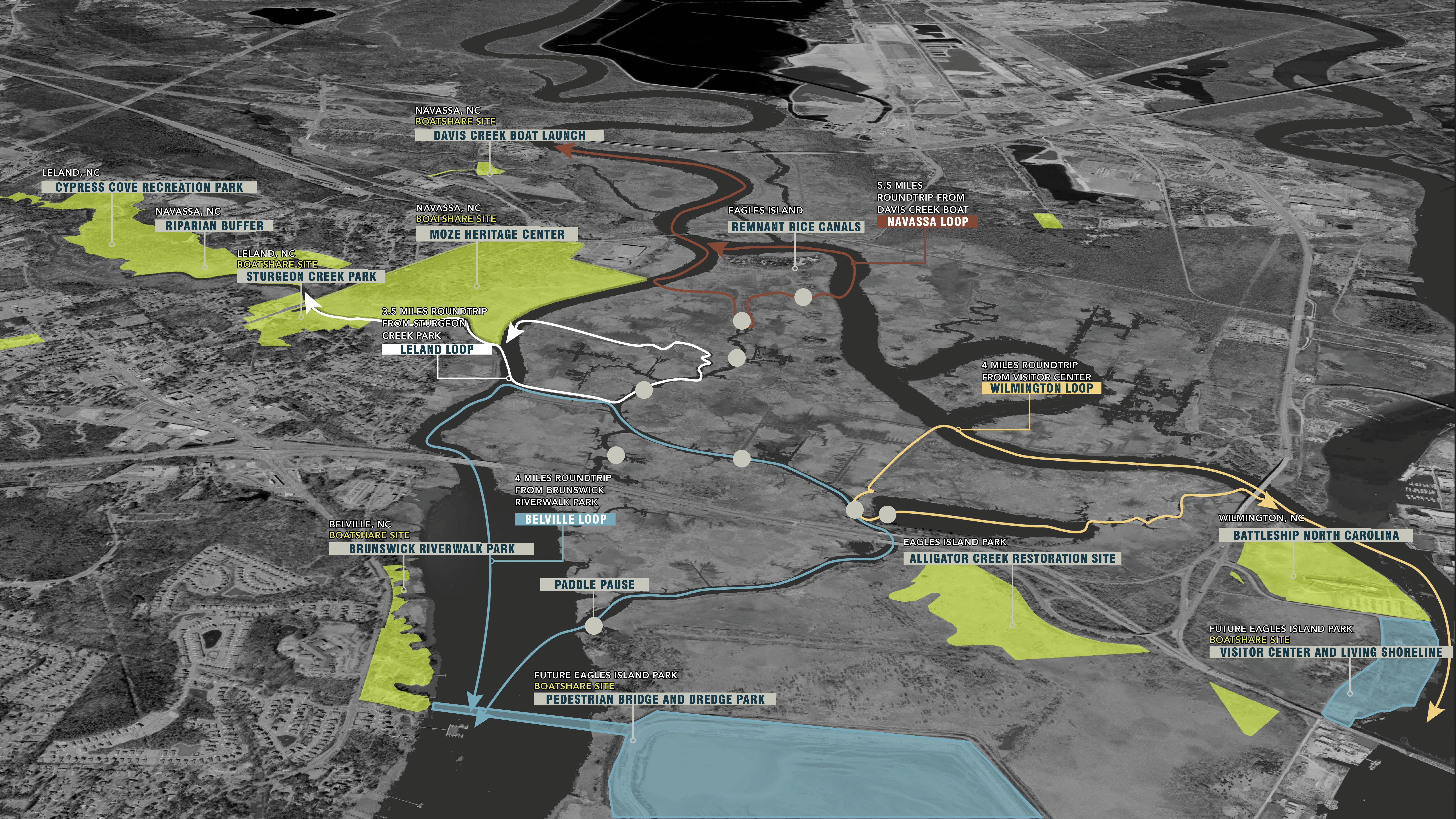
The plan supports connections to other community centers, reaching out along the western edge of the park to engage Belville, Leland, and Navassa across the Brunswick River. A pedestrian bridge from Brunswick Riverwalk Park in Bellville will provide community access directly to the reimagined dredge spoils, with this site chosen because of its proximity to a Belville school and potential to facilitate educational experiences. A concentration of boat-share rental sites in Leland and Navassa parks will allow these communities to explore the remnant rice canals built by the Gullah Geechee people.
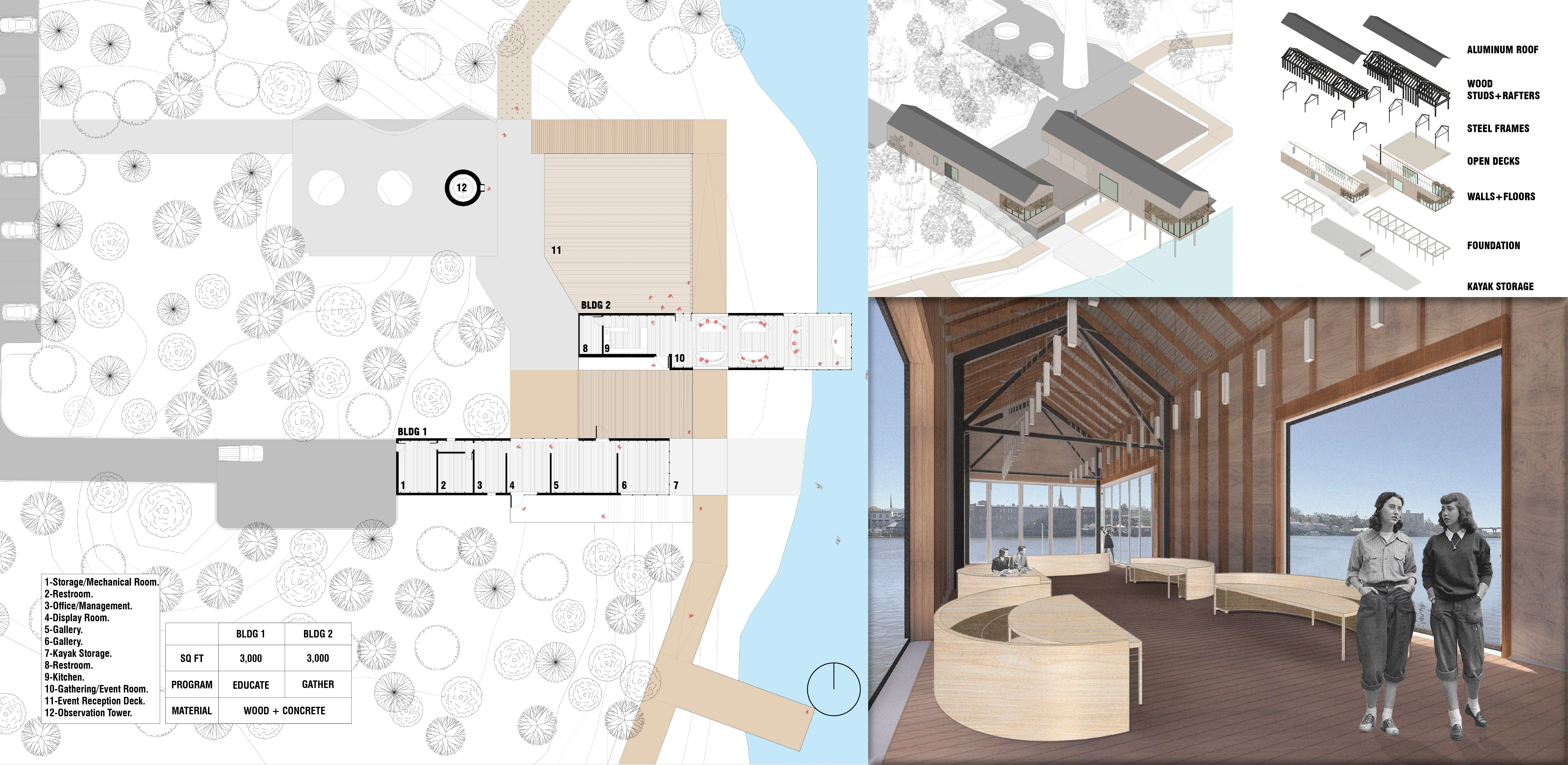
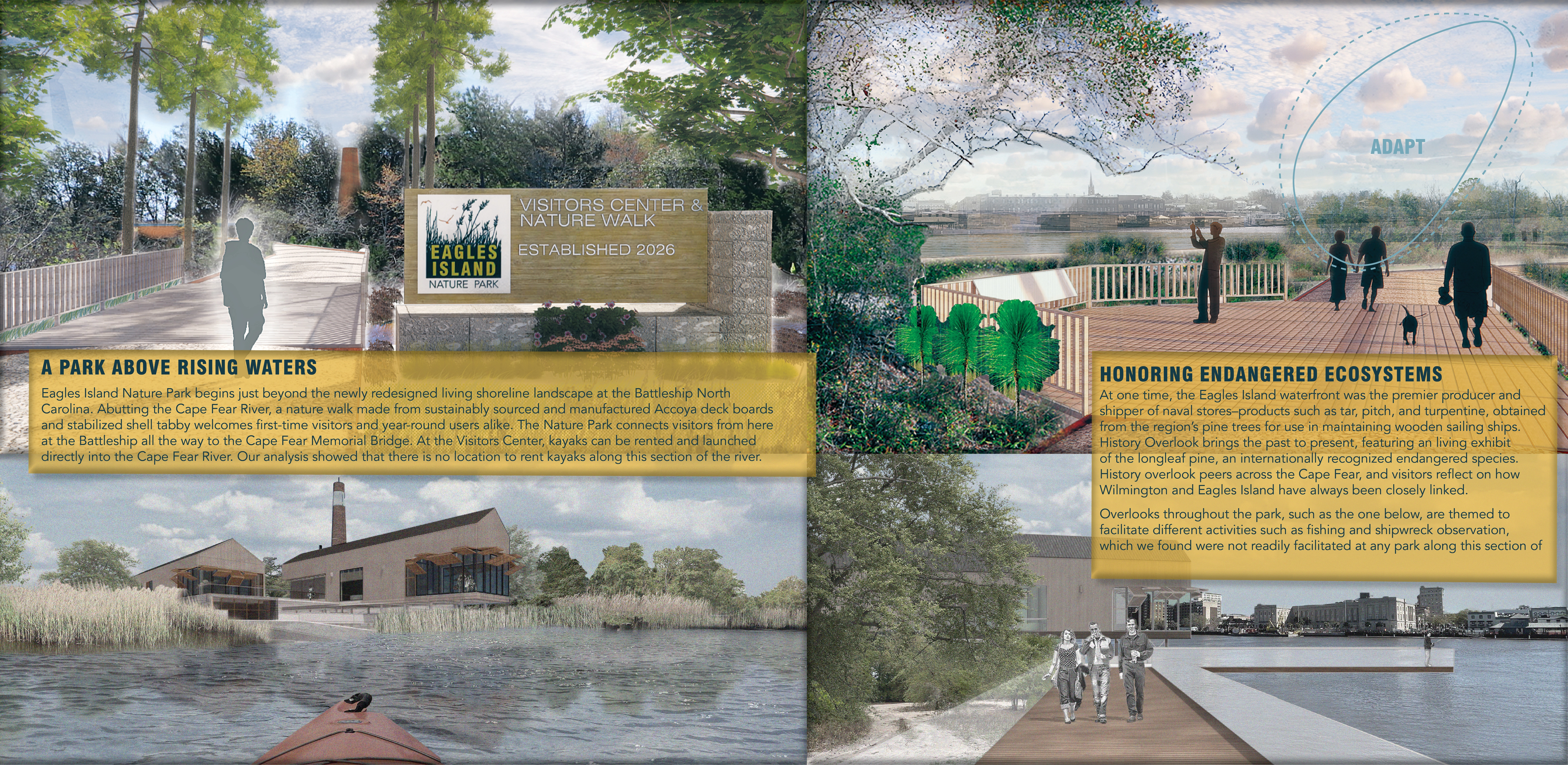
The proposal challenges the plan for a hotel on the high ground near the Battleship, North Carolina, instead using this land for a Visitors' Center. The Center is a major node, introducing visitors to the complex natural systems at work throughout the island and providing access to the reimagined dredge spoils and historic rice canals as the launch point of our park ferry system. Accessible by a ferry from downtown Wilmington, the Center draws people to the island.
ADAPT
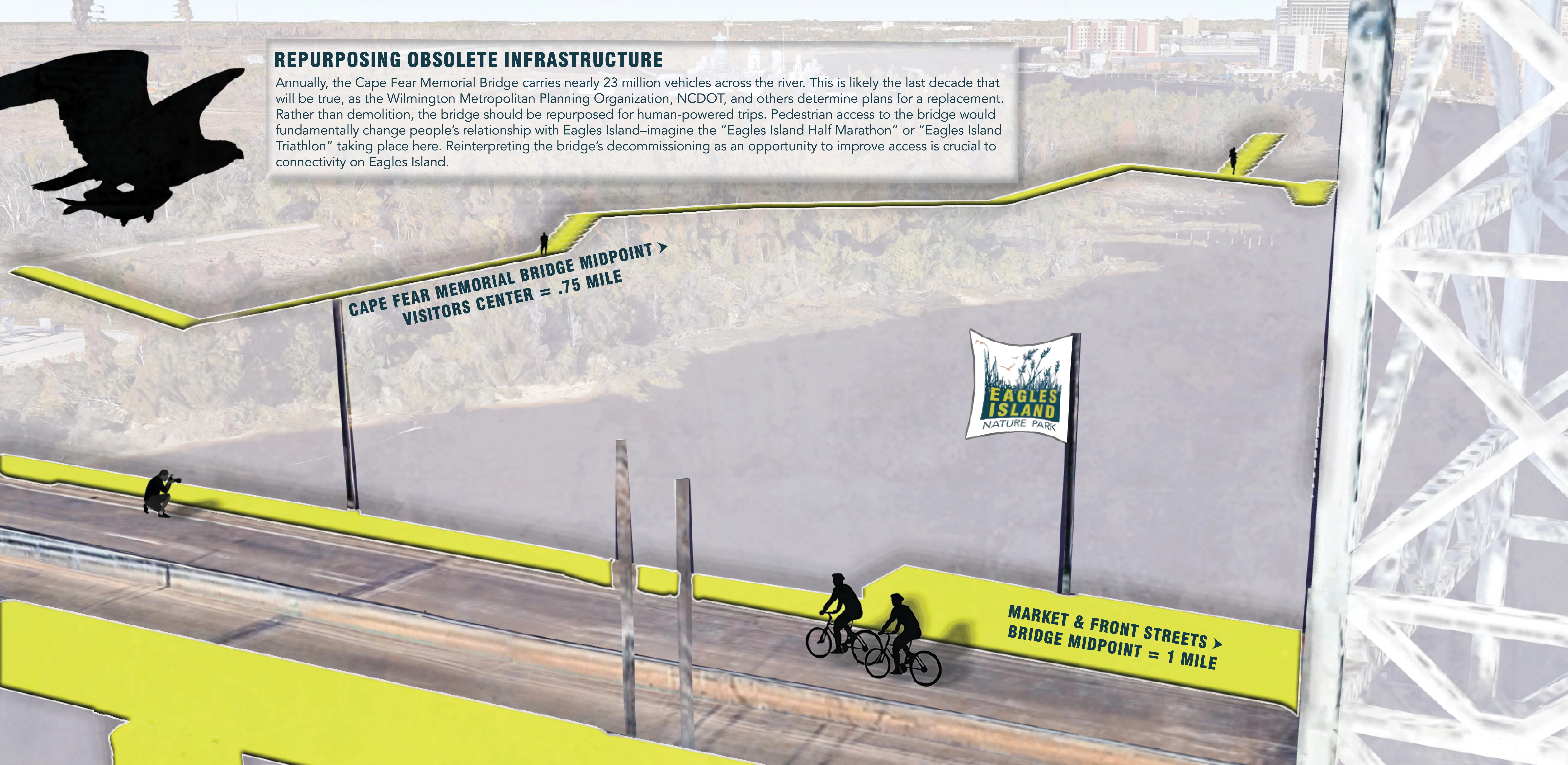
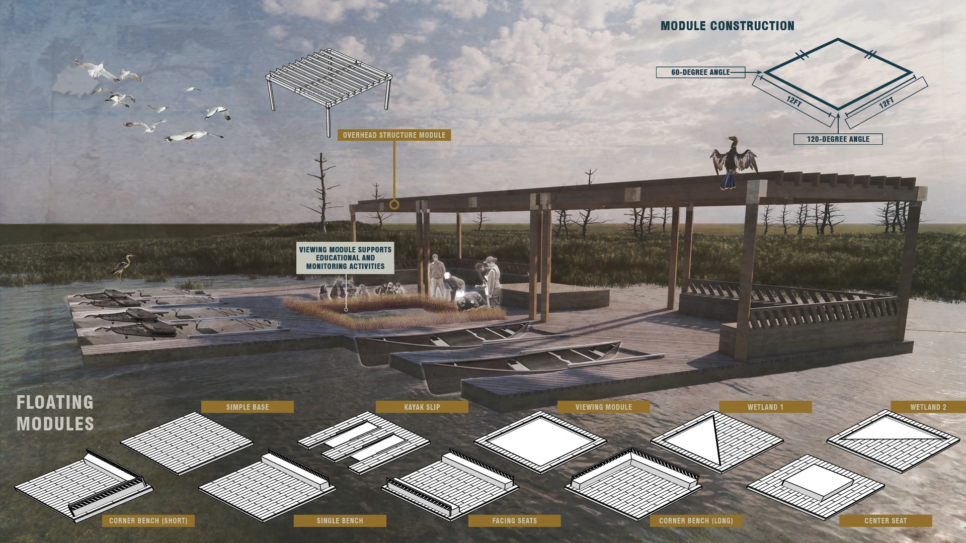
Adaptation drives the park’s design. The living shoreline surrounding the Visitor’s Center buffers against storm surge and, over time, evolves with rising water levels. Adaptive reuse of the Cape Fear Memorial Bridge saves the structure from demolition after its decommissioning and creates a vital, multi-modal connection between the park and its adjacent communities. Phytoremediation of the dredge spoils transforms a waste landscape into renewed habitat that supports a healthy upland ecosystem. Implementation of flexible floating dock systems, called Paddle Pauses, enable exploration of the rice canals in the near-term while allowing for new, future programs to support the developing ecological and cultural realities. By embracing future conditions, rather than fighting against them, this park proposal benefits multiple generations.
INSPIRE
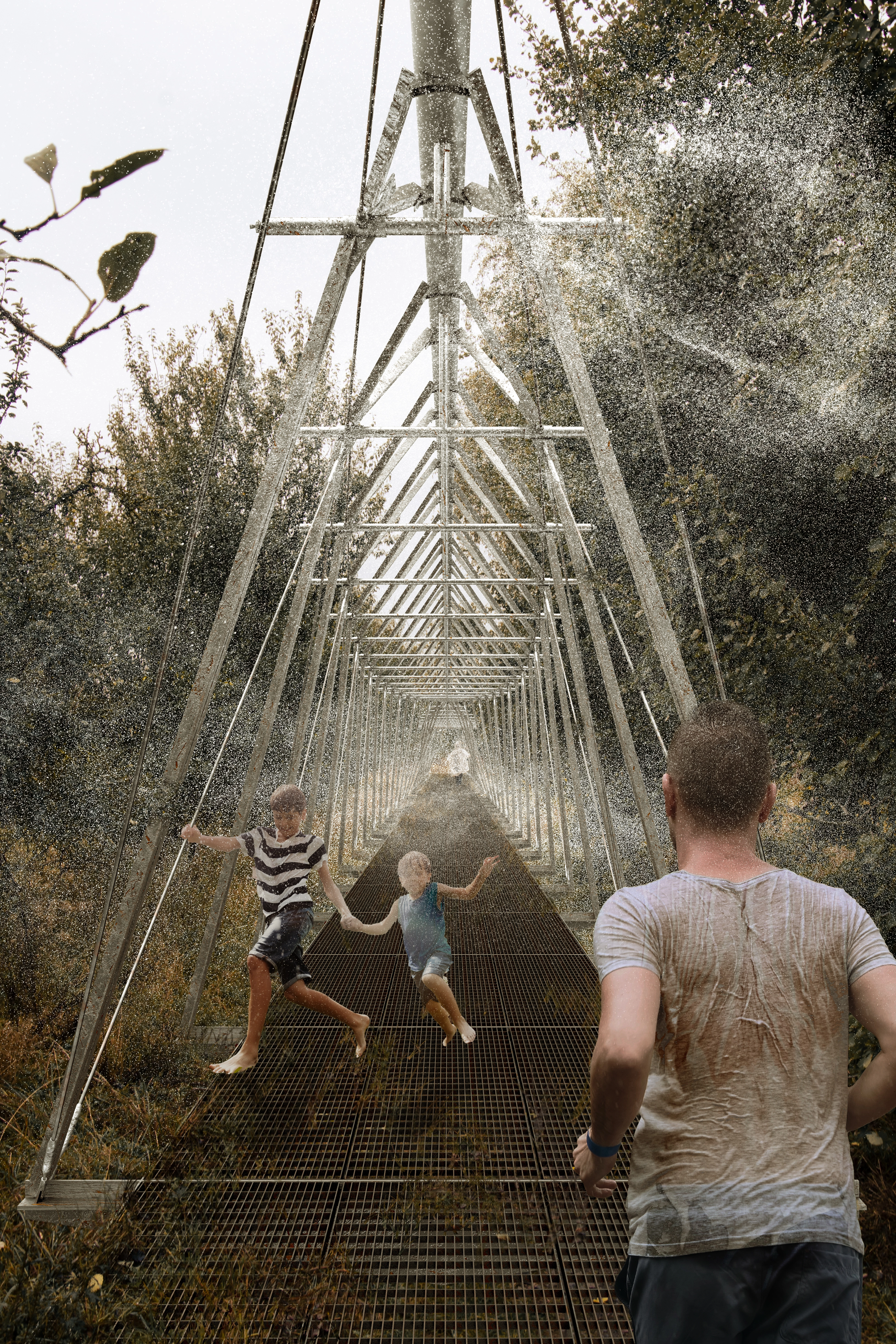
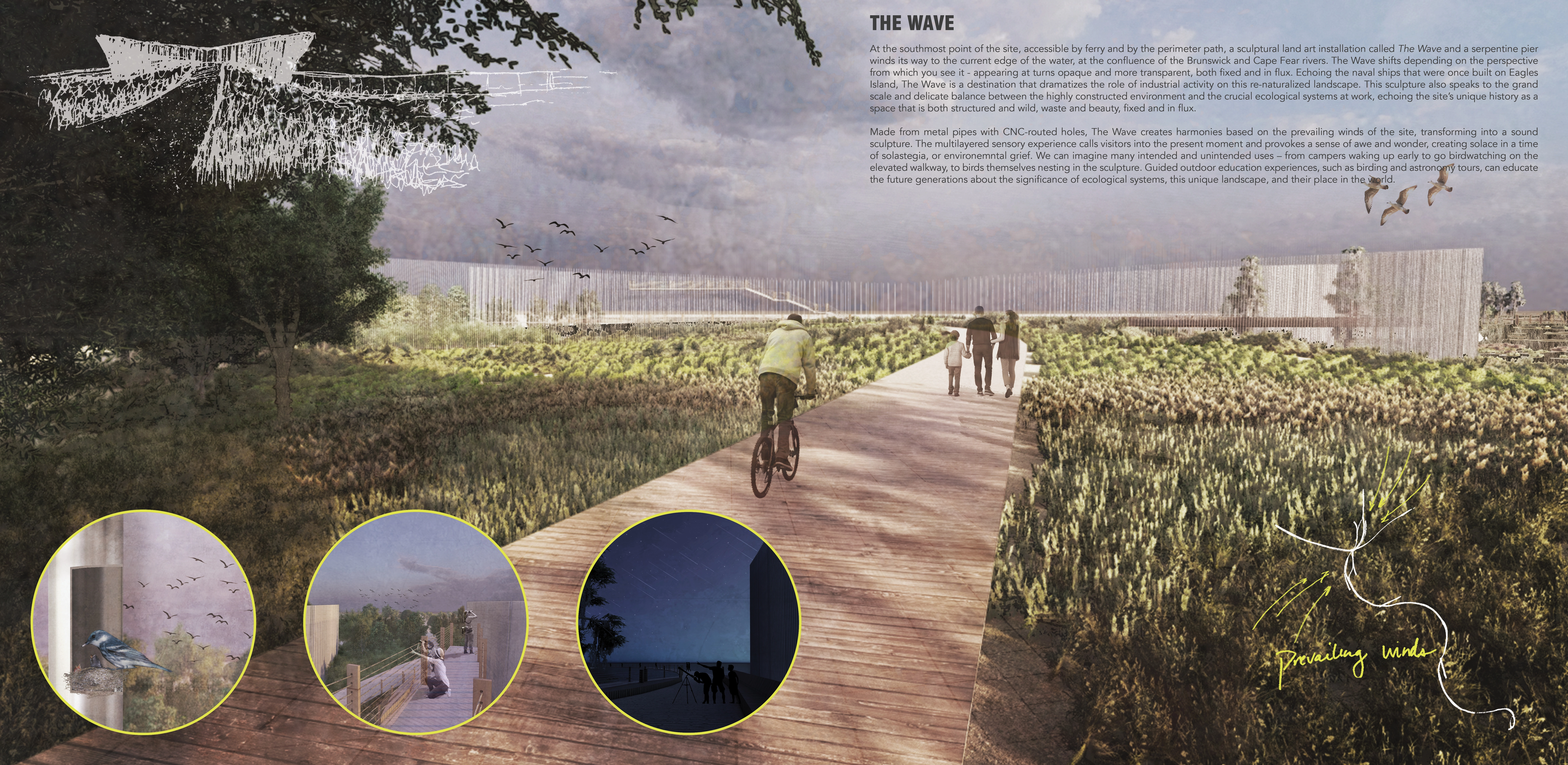
Connecting to cultural history of the site with blueways along the planned Gullah Geechee Heritage Trail highlights both the history of the land as well as the living Gullah Geechee community. Introducing people to a history integral to the culture of the coastal plain, as well as providing space for the community that is very much alive. Environmental education inspires the next generation to be stewards of this landscape through programming and design. Public art and experiential landscapes such as The Wave provide a fixed frame that juxtaposes the fluid nature of natural systems. Through multiple channels, we strive to restore a corporeal connection to the water by taking an approach that embraces rather than resists the rising tides.
-
- Lloyd Singleton - Director, NC Cooperative Extension, New Hanover County Center / Project Client, Eagles Island Central Park Task Force
- Evan Folds - Supervisor, New Hanover Soil & Water Conservation District / Project Client, Eagles Island Central Park Task Force
- Amy Mead - Area Agent, NC Cooperative Extension, Brunswick County Center / Project Client, Eagles Island Central Park Task Force
- Jesse Green, AIA, LEED AP - Design Principal, Hanbury / Coastal Dynamics Studio Partner
- Shawna M. Mabie, AIA, LEED AP BD+C, WELL AP - Associate, Project Manager, Hanbury / Coastal Dynamics Studio Partner
- Captain Doug Springer - Founder, Cape Fear Water Tours / Eagles Island Historian
- Brayton Willis - Chairman, North Carolina Gullah Geechee Greenway - Blueway Heritage Trail Project / Project Advisor
-
- Narrow leaf sunflower
- Cherokee sedge
- Carolina willow
- Smooth cordgrass
- Saltmeadow cordgrass
- Black rush
- Desert saltgrass
- Big cordgrass
- Saw-grass
- Bushy seaside tansy
- Starrush whitetop
- Virginia saltmarsh mallow
- Firewheel
- Prickly pear
- Black eyed susan
- Yucca
- Saltbush
- Wax myrtle
- Yaupon holly
- Loblolly pine
- Longleaf pine
- Red bay
- Bald cypress
- Live oak
- Sand live oak
- Red maple
- Swamp hickory
- Saltmeadow cordgrass
- Sabal palm
Advertisement
Related Awards
Honor Award, Student Collaboration
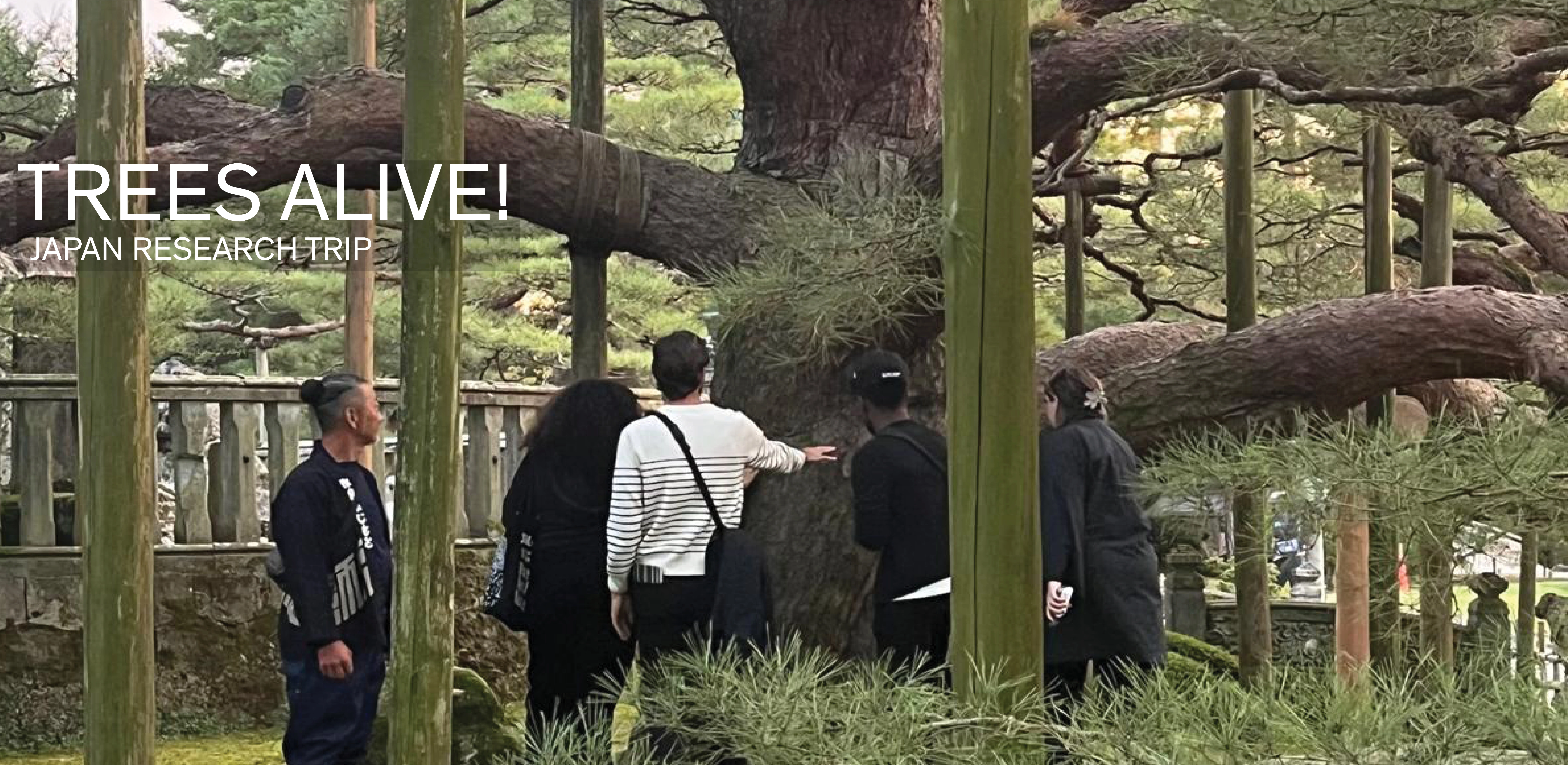
TREES ALIVE!: Techniques, Details, Traditions
TREES ALIVE! is a collaborative research and travel exchange between American and Japanese landscape architecture programs to study the techniques, details, and cultural traditions for trees in contemporary urban landscapes. Students participated in collaborative technical workshops and visits to significant gardens and landscapes to investigate urban tree planting and legacy tree conservation in Tokyo, Kanazawa, Chicago, Columbus (Indiana), Philadelphia, and New York. Two technical