
.webp?language=en-US)


2022 ASLA Professional Awards
Honor Award, Analysis & Planning
Accelerating Rural Recovery and Resilience: The Pollocksville Community Floodprint
Pollocksville, North Carolina, United States
Client: Town of Pollocksville, North Carolina
The place-based approach recognizes the financial realities, multigenerational social networks, and personal place attachments that must be considered in rural recovery processes. The team also identified potential funding sources and created support materials for seeking external investments, resources, and grants.
Awards Jury
-
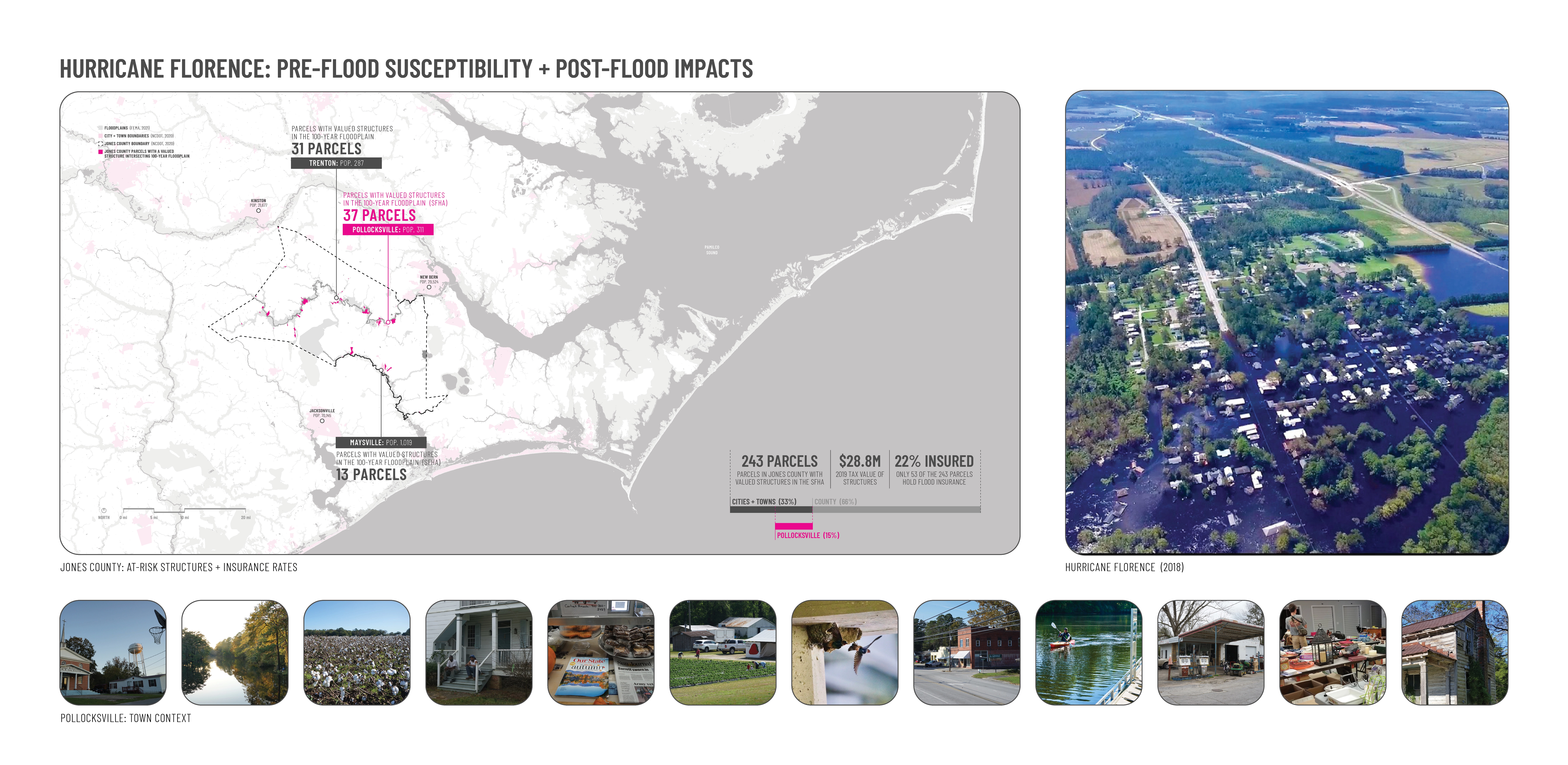
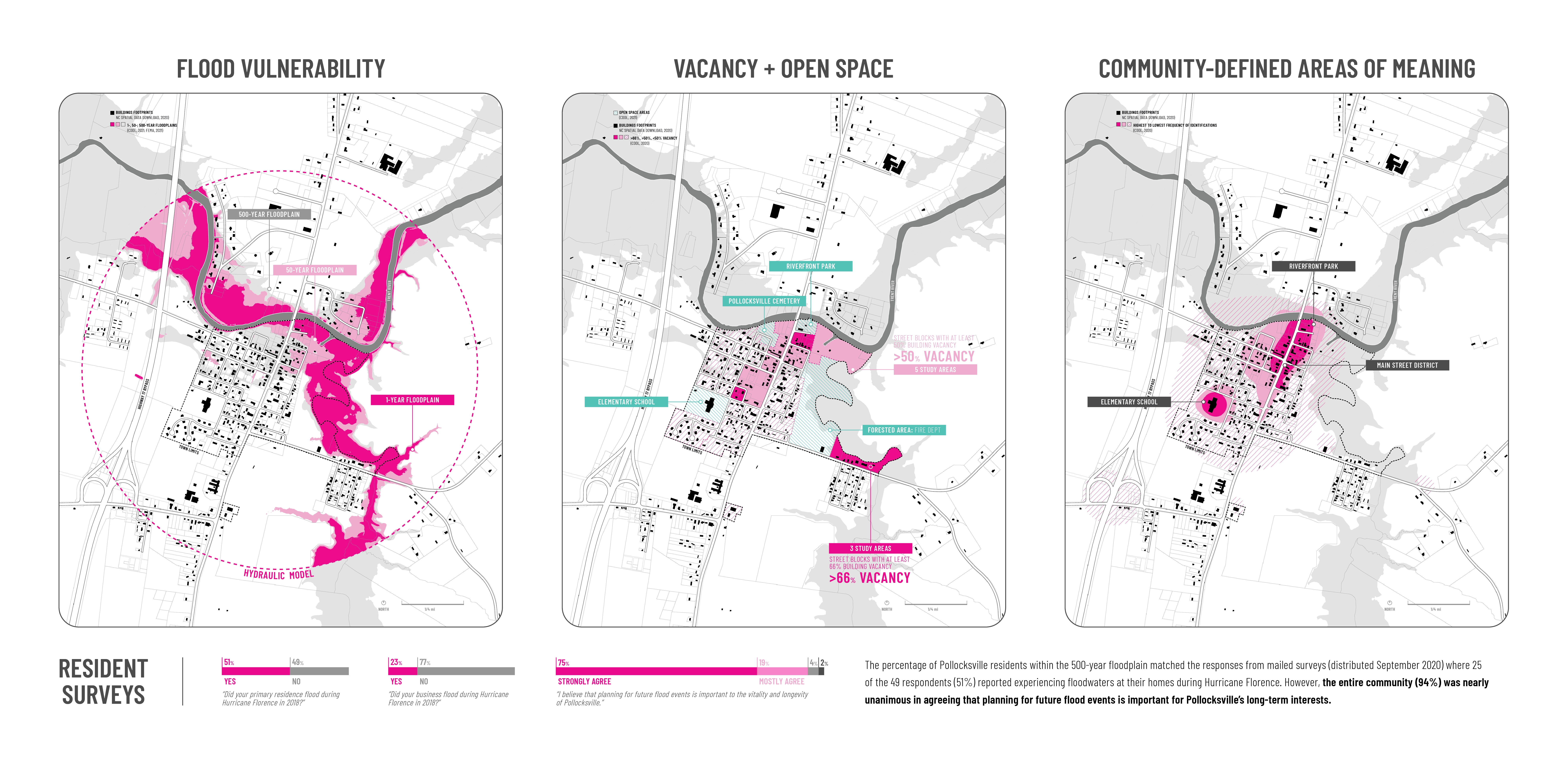
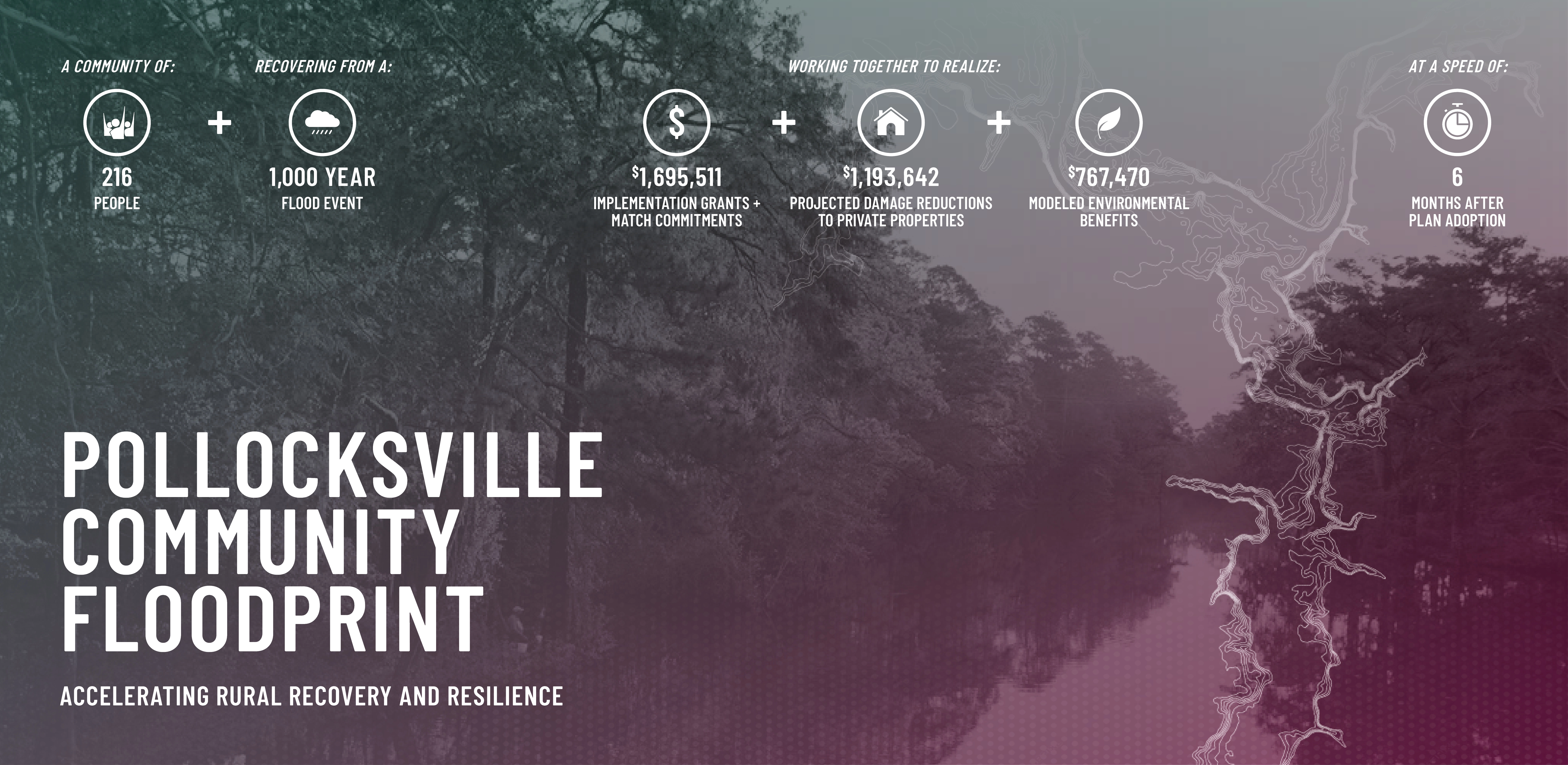
Pollocksville, North Carolina (population 216) is in the midst of a multi-year recovery process resulting from Hurricane Florence (2018). The rainfall generated by Florence was equivalent to a 1,000-year storm event, causing $17B in damages in North Carolina. In Pollocksville, the storm's flooding impacts far exceeded the 500-year floodplain, inundating dozens of homes and nearly two-thirds of the town’s commercial properties. The Pollocksville Community Floodprint bolstered local recovery efforts through an integrated portfolio of projects that were co-produced with the community via participatory processes and rigorous analysis. Outcomes are assisting local leaders make Pollocksville more resilient to future shocks. The project was rooted in place-based approaches to community planning and development, hazard mitigation, and climate adaptation. The plan recognizes the financial realities, multi-generational social networks, personal place attachments, and bespoke micro-migration strategies that must be considered in the recovery processes of low-wealth rural areas. The resulting town-adopted document illustrates processes that both respond to Pollocksville’s efforts to build back better and provide transferable lessons to other under-resourced communities that are disproportionately impacted by environmental threats.
-
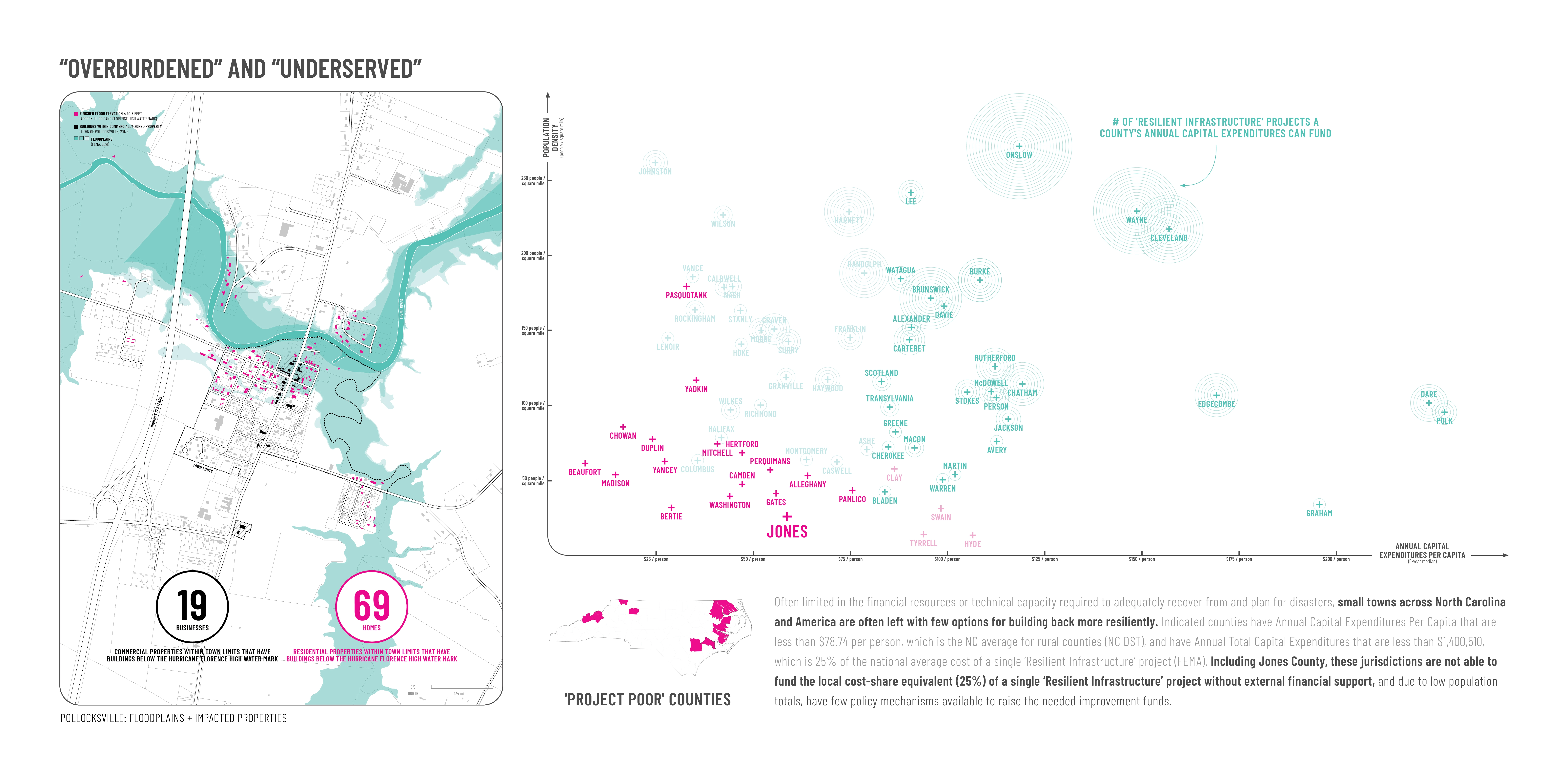
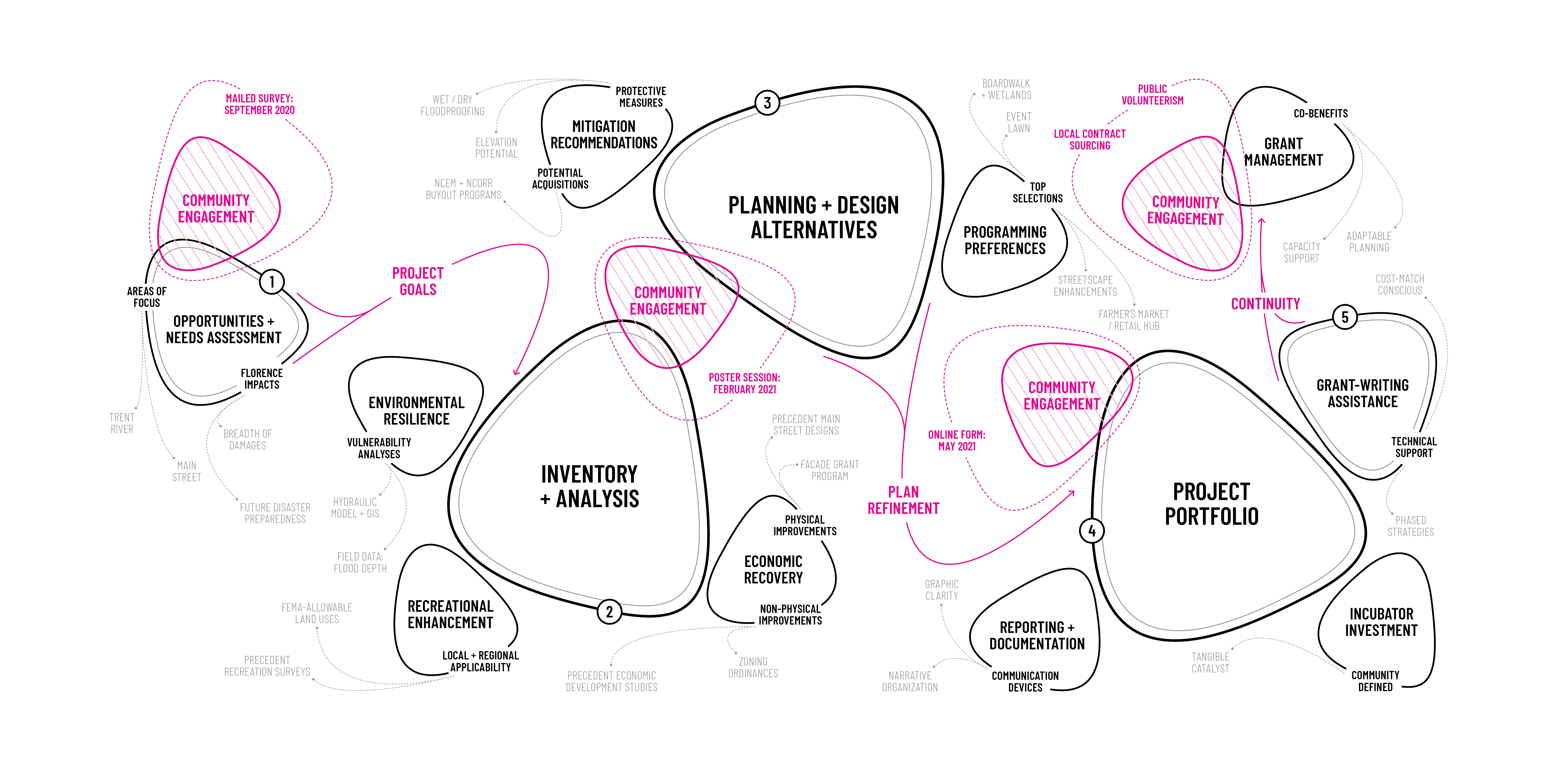
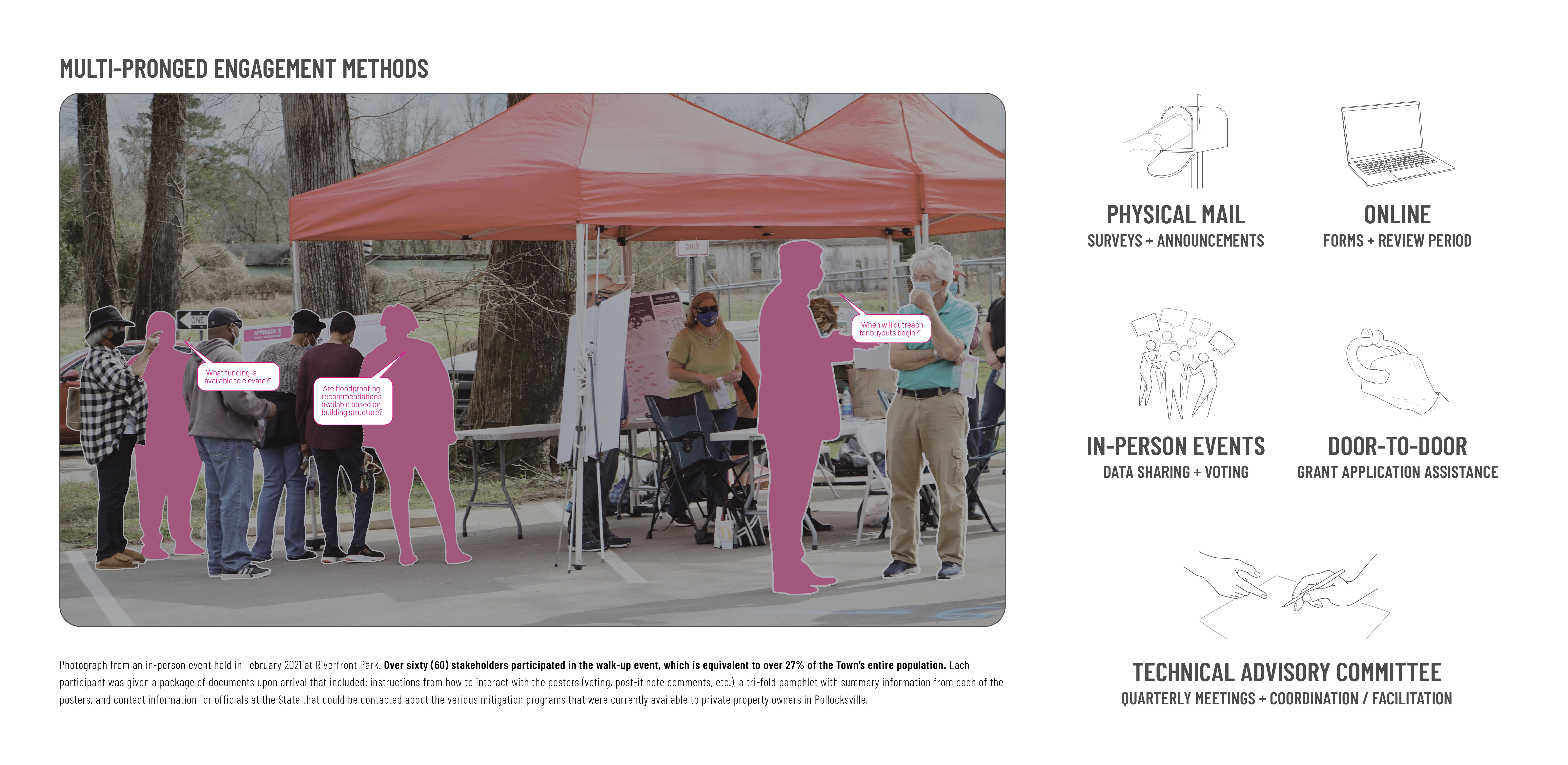
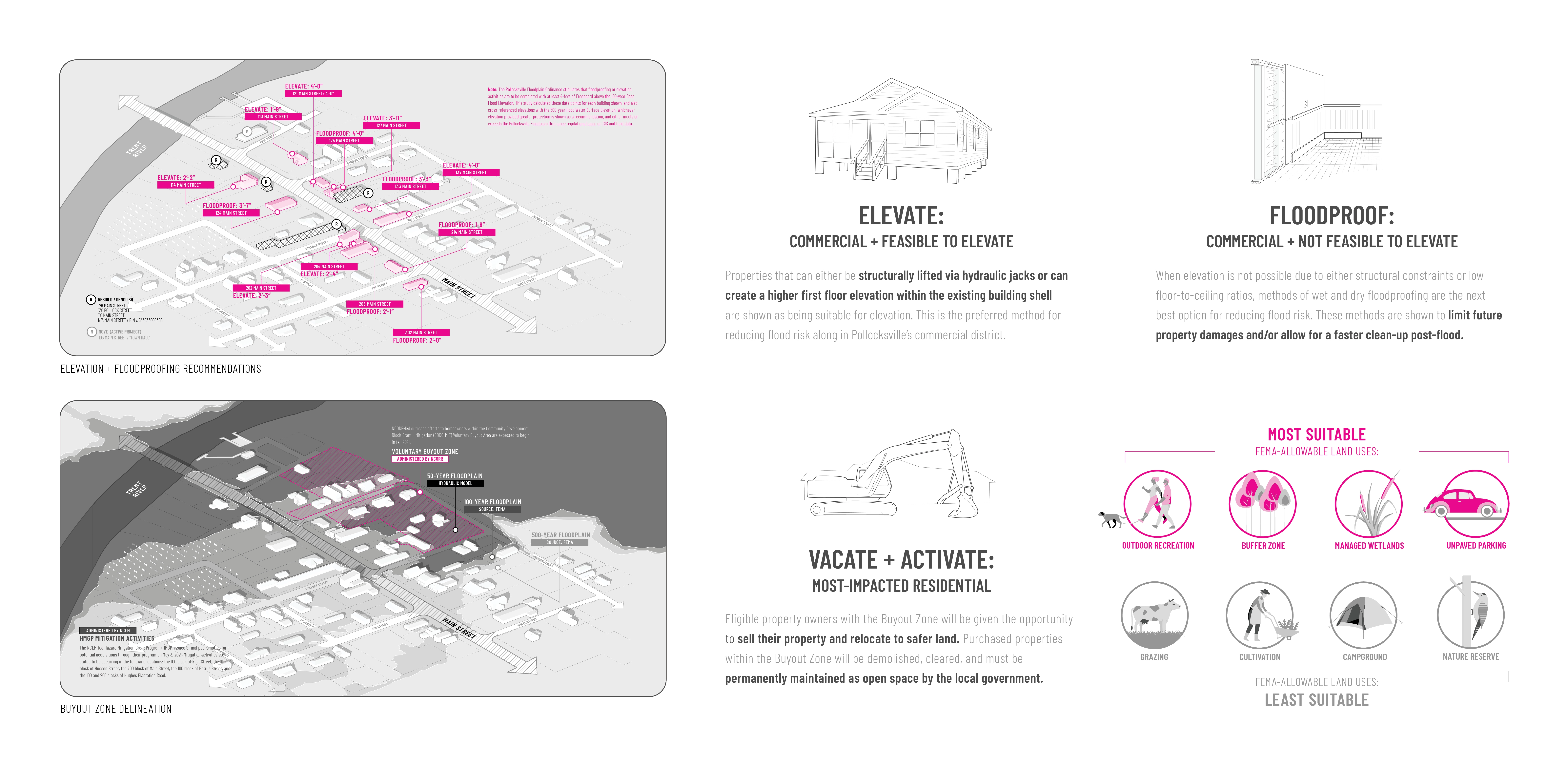
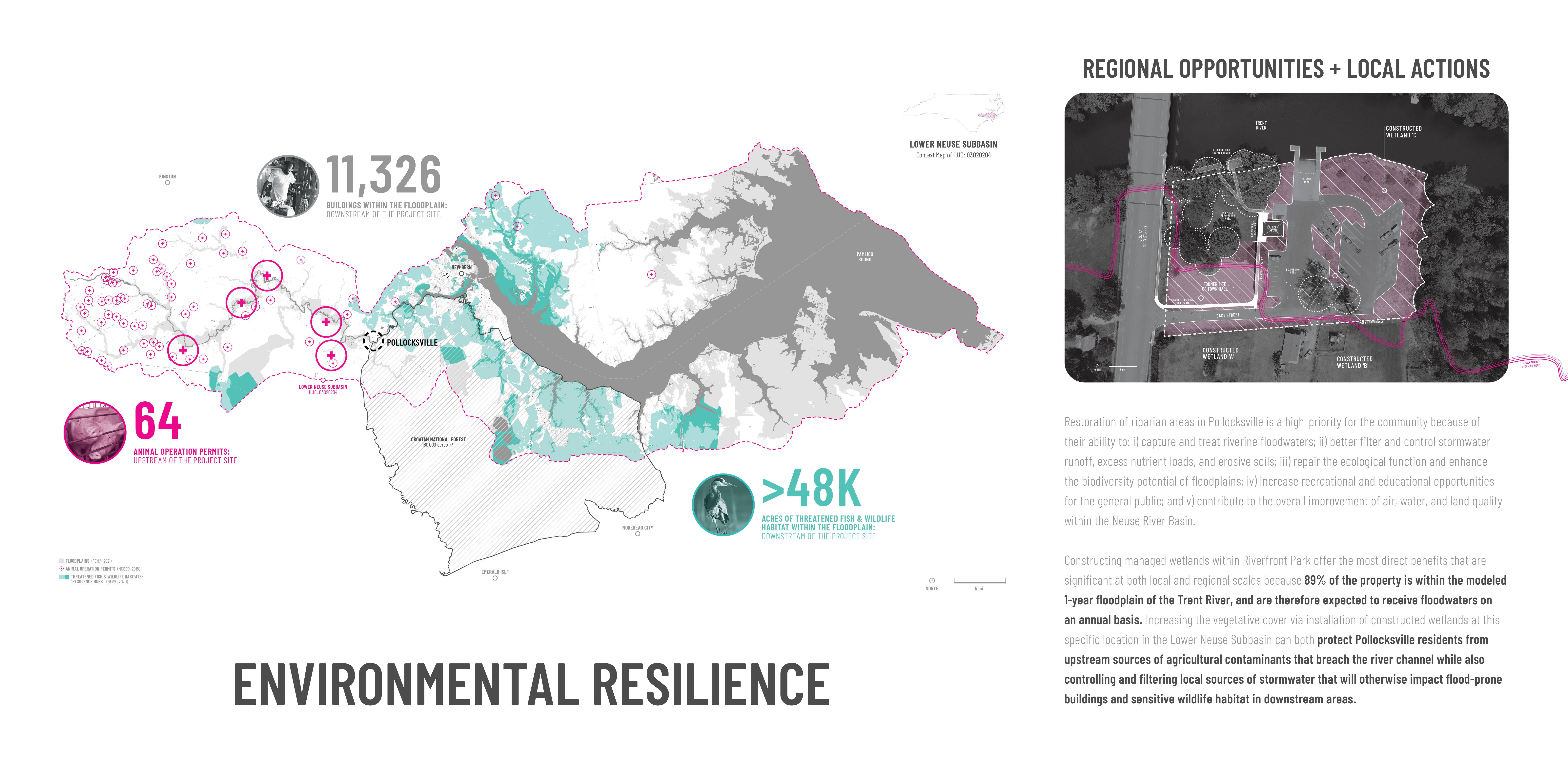
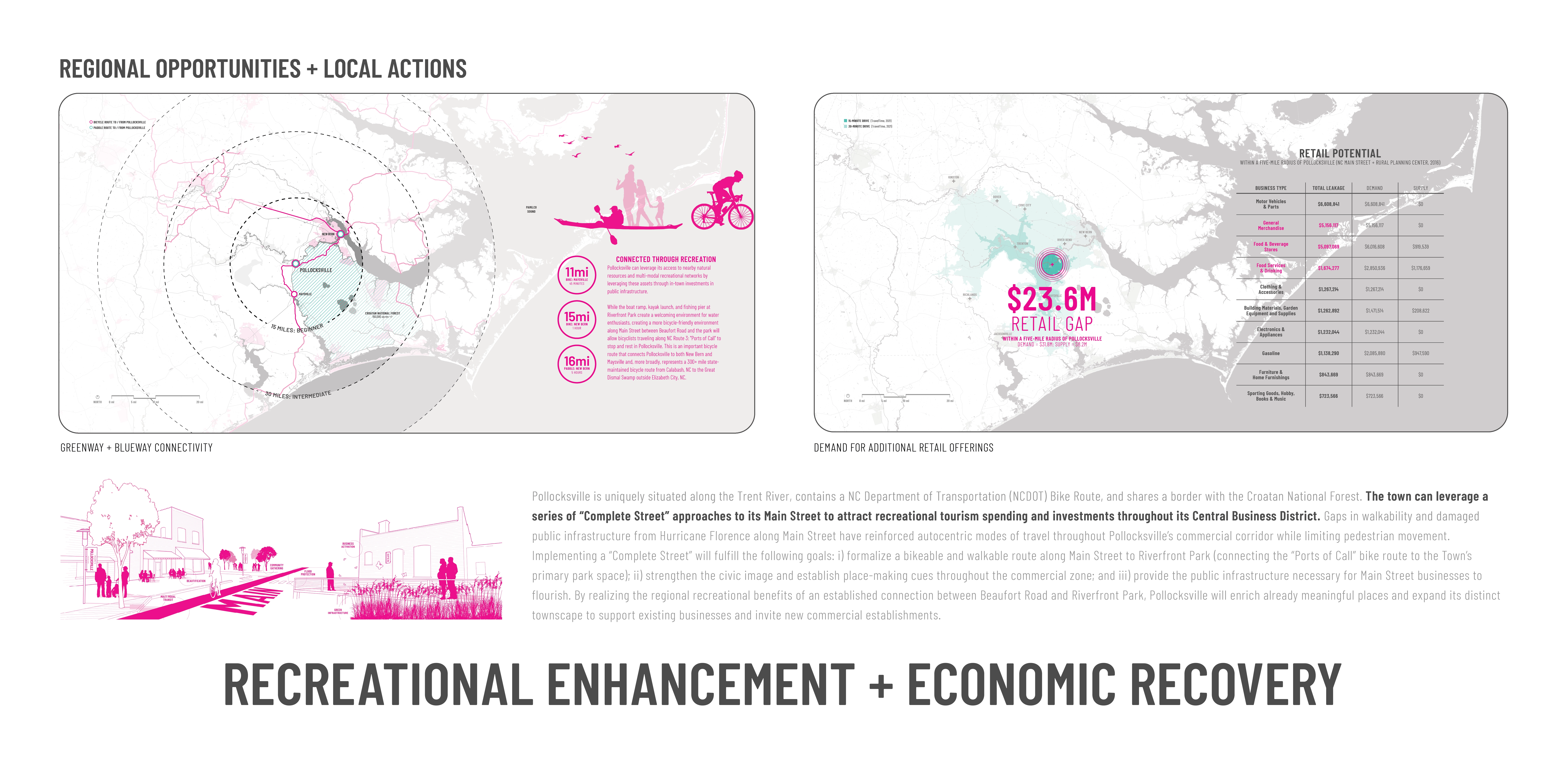
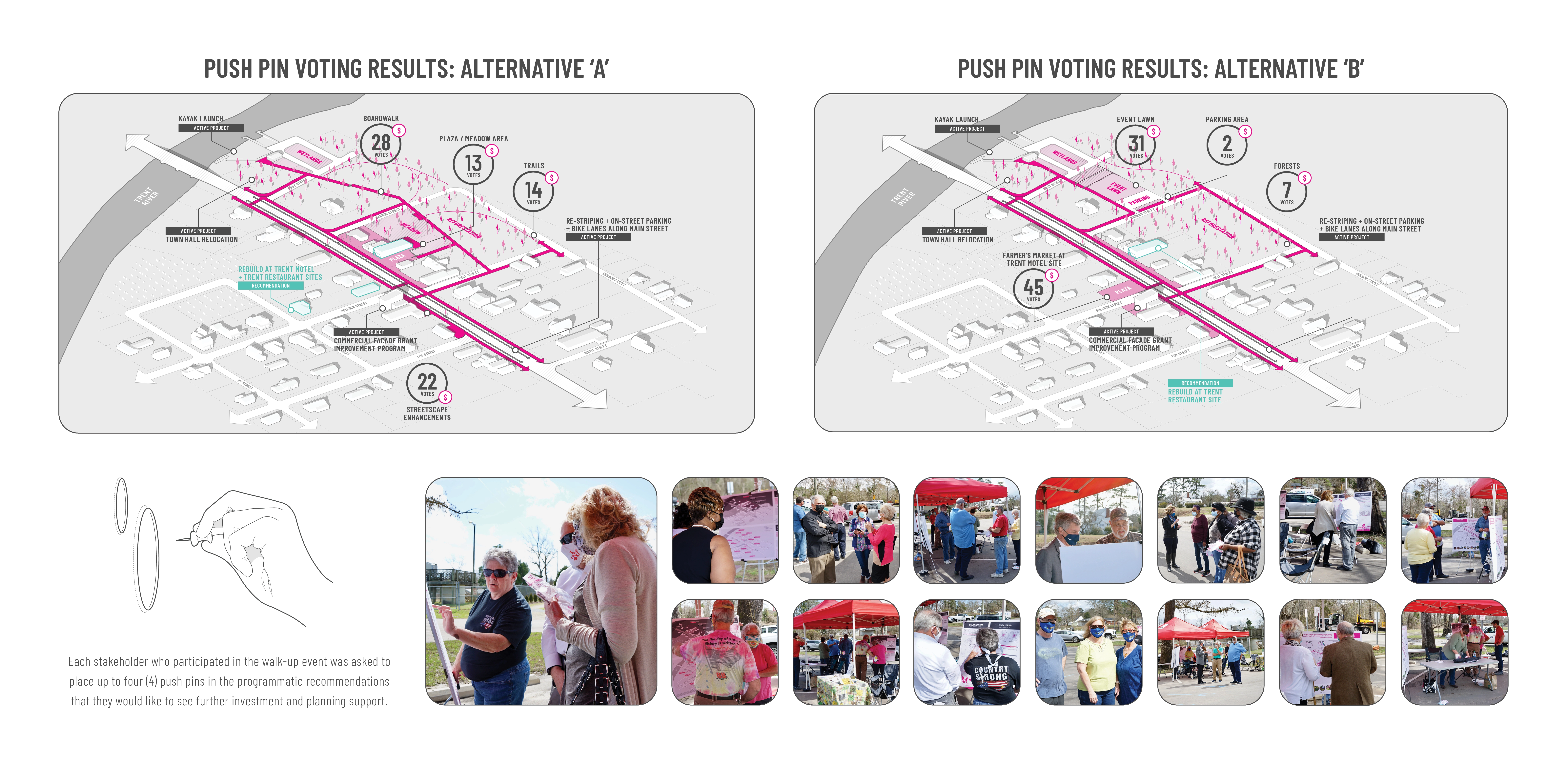
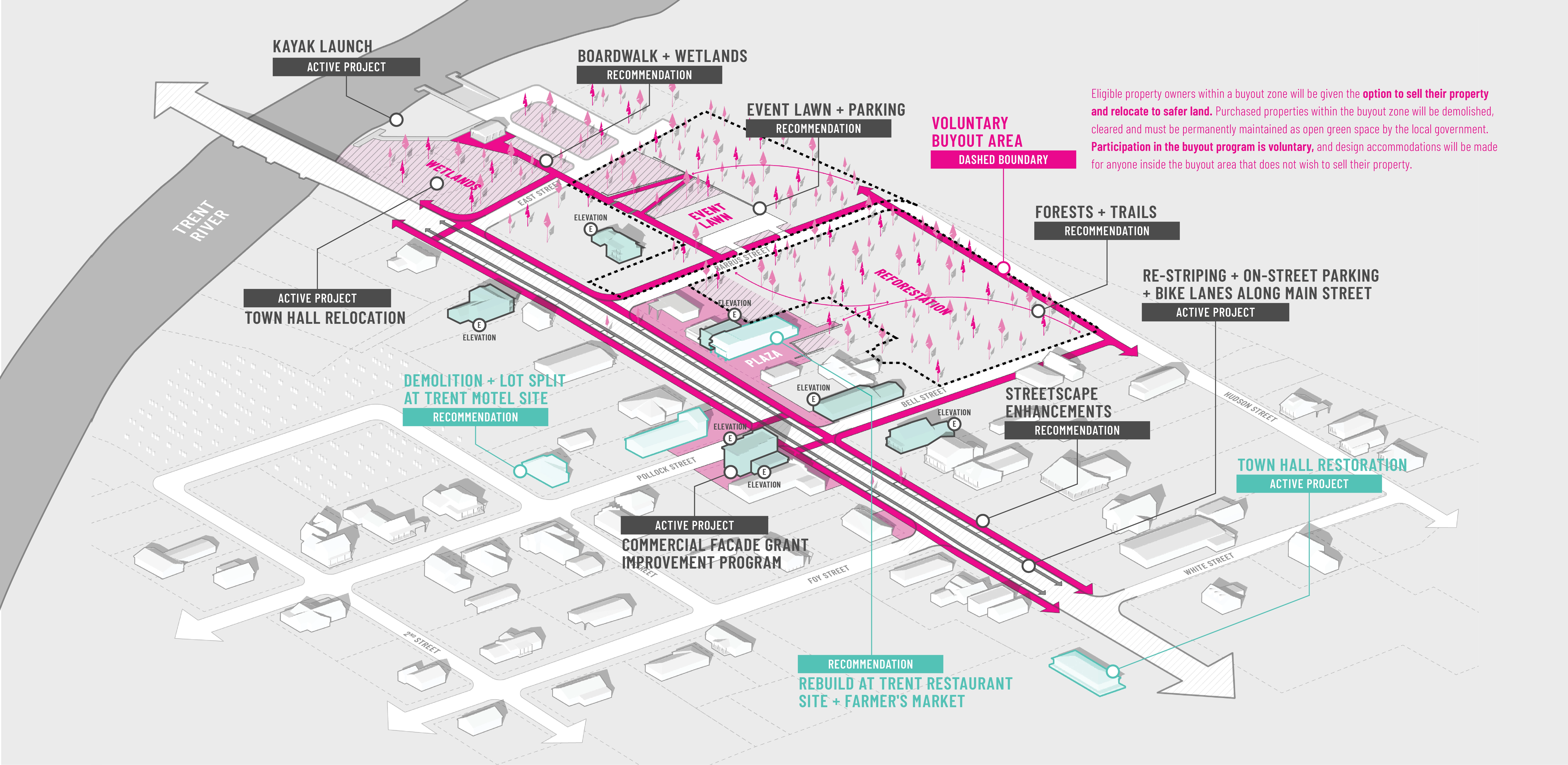
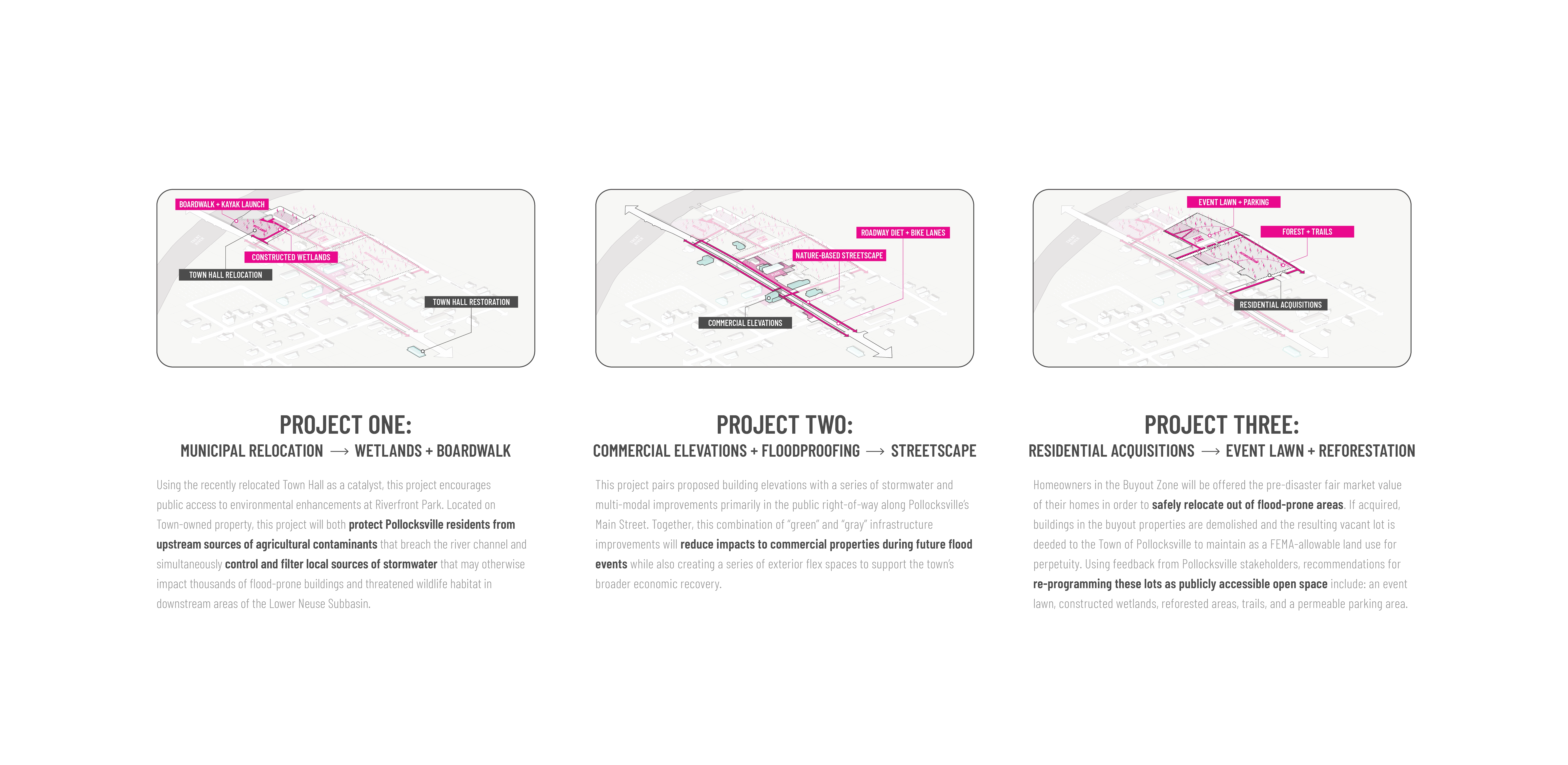
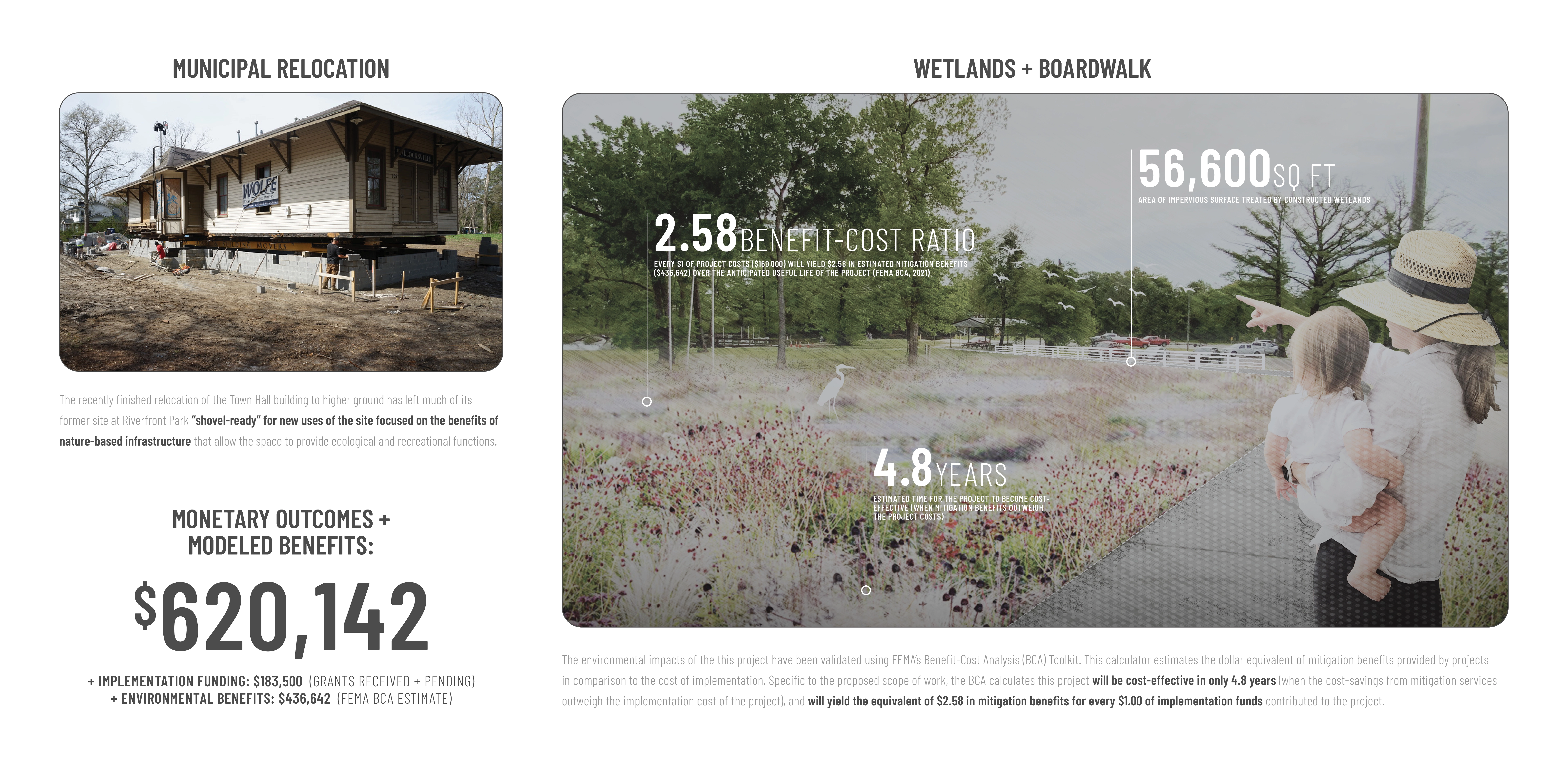
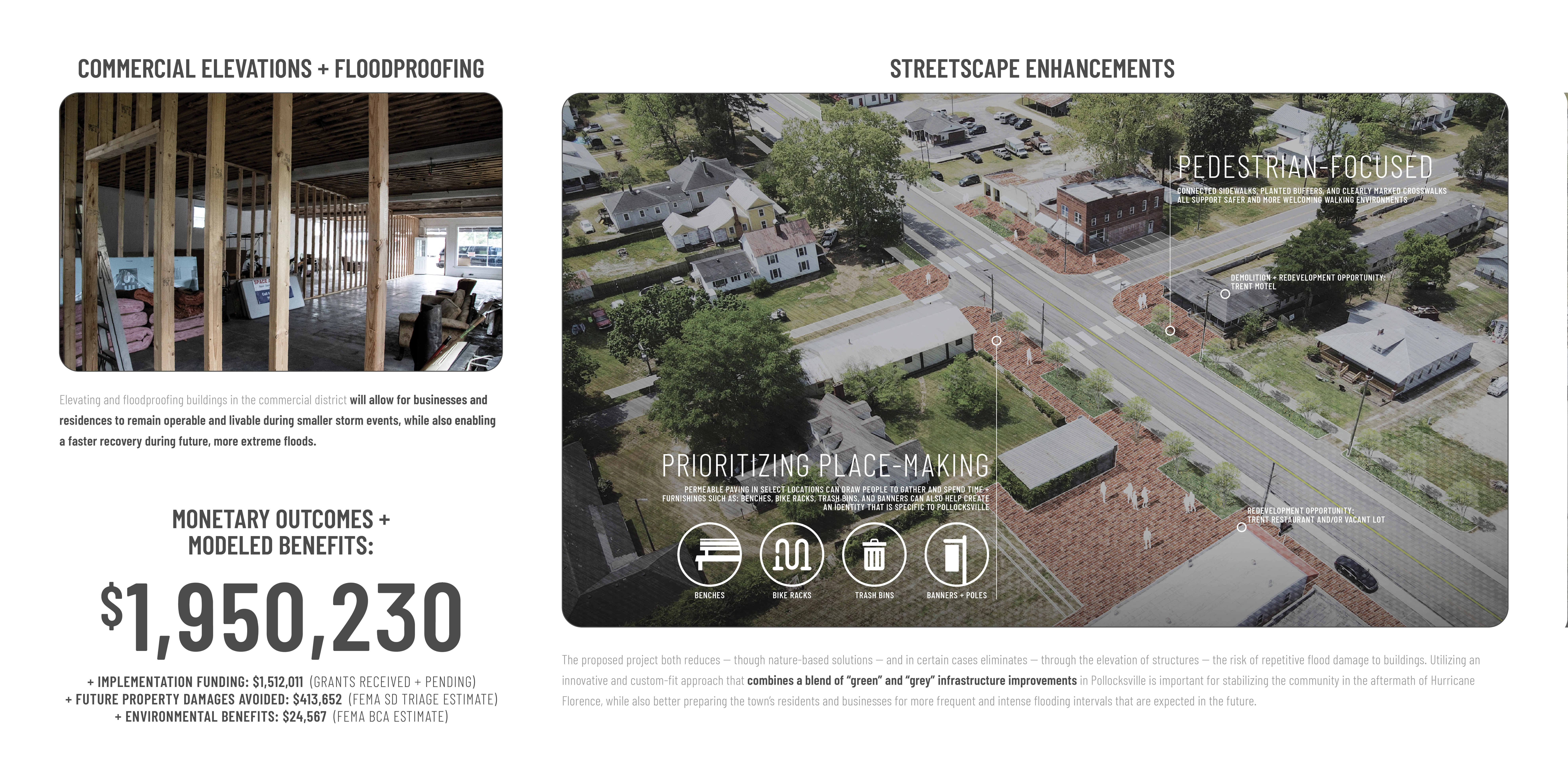
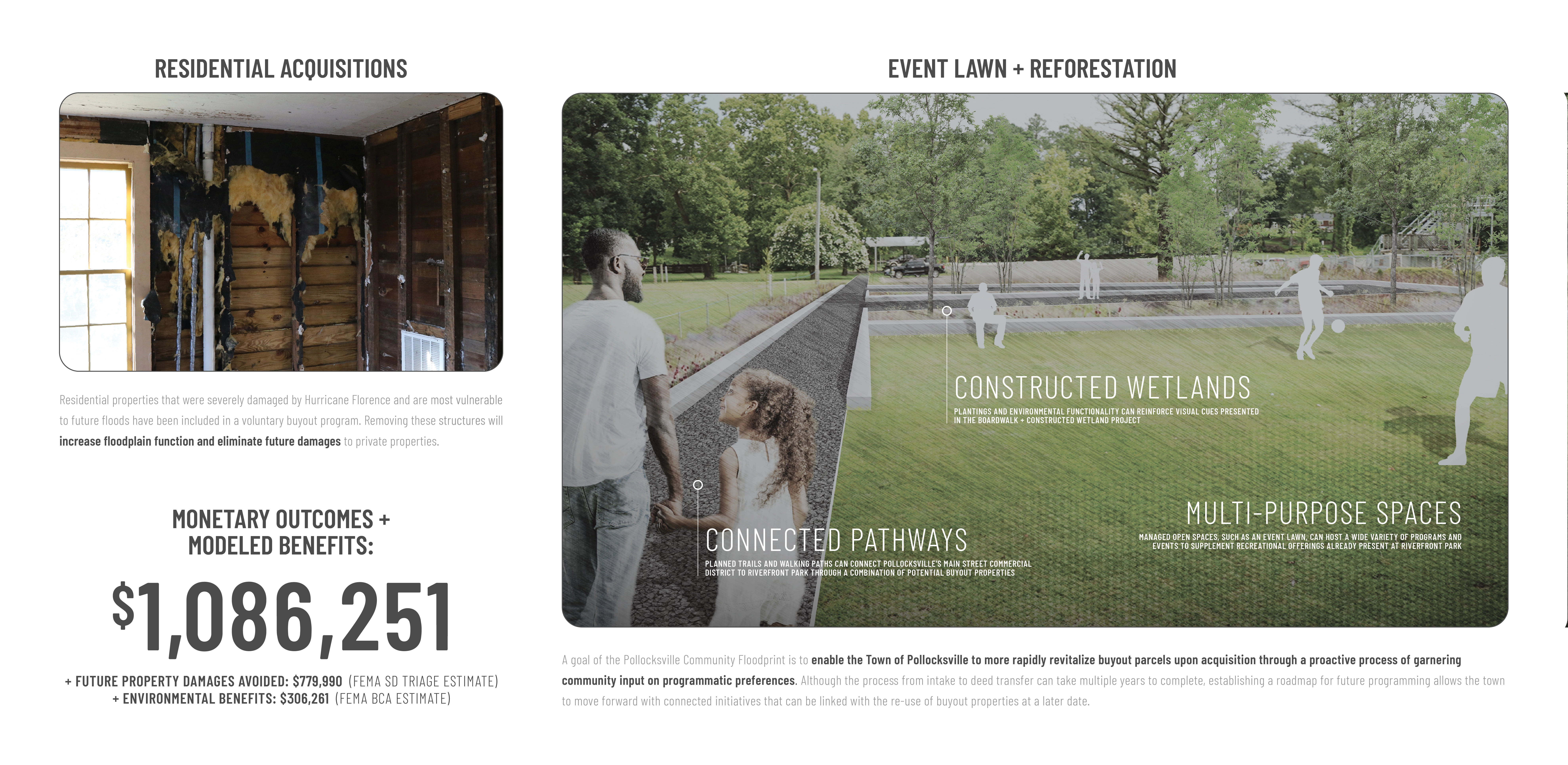
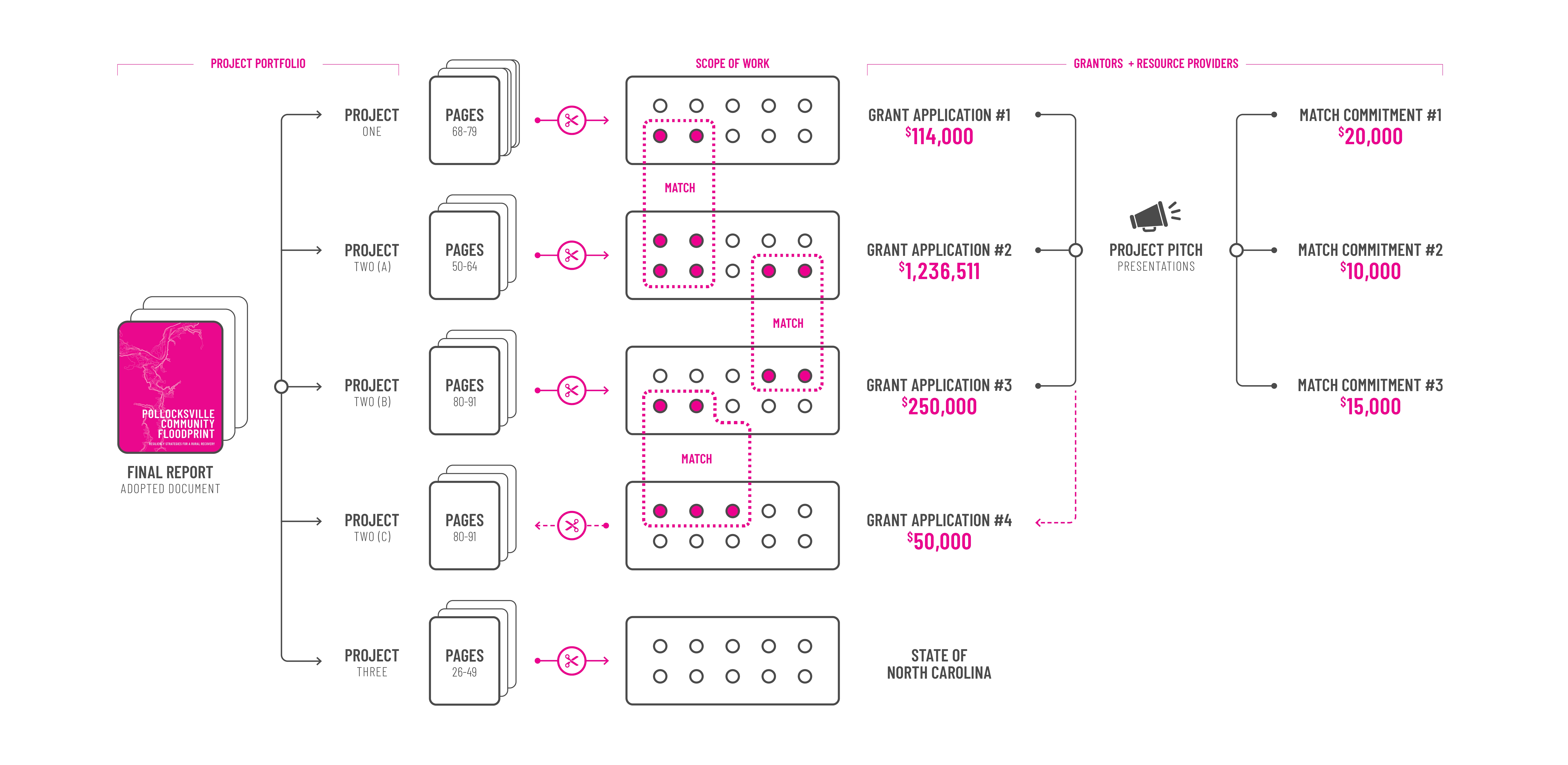
Overview: The Town of Pollocksville, North Carolina (population 216) is in the midst of a multi-year flood recovery process resulting from Hurricane Florence (2018). The rainfall generated by Florence was equivalent to a 1,000-year storm event, causing over $17B in monetary damages in North Carolina. In Pollocksville, the impacts of riverine flooding from the storm far exceeded the 500-year floodplain, inundating dozens of homes and nearly two-thirds of the town’s commercial properties. The Pollocksville Community Floodprint is bolstering community recovery efforts through an integrated portfolio of rebuilding projects. The project team led mixed-method participatory processes to co-produce the plan with the community. The rigorous planning and analysis undertaken by the project team continue to assist local leaders attract the financial resources needed to make Pollocksville a vibrant place to live and work while simultaneously increasing its resilience to future shocks. Context: The Town of Pollocksville is a small, rural community located on the banks of the Trent River in Jones County, North Carolina. Like other places across Eastern North Carolina, Pollocksville is deeply rooted in an agrarian past. The community maintains a direct connection to agricultural commodities including corn, soybean, cotton, and timberlands that adjoin much of the town’s periphery. Pollocksville is increasingly referred to as the “Gateway to Nature” due to its direct access to the Trent River, the Croatan National Forest, and classification as a Bird Sanctuary. In recent years, Pollocksville has leveraged its location through investments in its Riverfront Park, fishing pier, and kayak launch. These amenities, combined with the existing building stock in the Main Street commercial district and newly completed NC Highway 17 exit that accesses the town, afford Pollocksville a unique opportunity to rebuild in a way that increases its overall community resilience – social, economic, and environmental. Rural, Overburdened & Underserved: Often limited in the financial resources or technical capacity required to adequately recover from and plan for disasters, small towns across America are often left with few options for building back more resiliently. Specific to Eastern North Carolina, the long-term planning processes and infrastructure projects required for improved community resilience are seldom accessible. For citizens of Pollocksville, and more generally Jones County, the community faces a combination of demographic and environmental vulnerabilities that meet the U.S. Environmental Protection Agency criteria for both an “overburdened” and an “underserved” community. In the census tract that includes Pollocksville, the average per capita income is $22,183 (NC average: $30,783), the percent of the population age 65+ is 23.5% (NC average: 16.7%), and the percentage of the population who identify as People of Color is 40.5% (NC average: 29.4%). These figures: i) represent income, age, and race characteristics that are representative of a community with elevated social vulnerability risk factors; and ii) contribute to the inability of Pollocksville residents to attain the resources necessary to make the community more resilient to environmental stressors. As witnessed after Hurricane Florence, these vulnerabilities become active threats to life and property during and long after a natural disaster. Pollocksville and Jones County also face significant obstacles to financing the infrastructure projects needed to better prepare for weather extremes. Of the 80 counties classified by the NC Rural Center as having ‘rural’ population densities, 17 of them (including Jones County) share the dual characteristics of having: i) annual, per capita capital expenditure budgets that are less than the average for NC rural counties ($78.74/person/year); and ii) total budgets for annual capital expenditures that are not able to finance the local cost-share requirement (25%) of a single ‘resilient infrastructure’ project based on 2020 national average costs ($1,400,510.00, FEMA). Together, these data points suggest that without external financial support, communities in Jones County are both under-resourced compared to other rural counties in the state and lack the ability to self-fund capital improvement projects that may be necessary for community viability and sustainability. The Pollocksville Community Floodprint responds to these financial and technical challenges by strategically aligning community-identified values for resilience with potential funding sources that are external to local funding streams, and creating support materials that make Pollocksville more competitive to receive the external investments, grants, and resources it needs and deserves. Role of the Landscape Architect: As documented in Pollocksville and other rural communities, the overlap of vulnerable populations and heightened environmental risks imposes barriers to accessing the long-term technical support and financial resources needed to better prepare for future disasters. In response to these shortfalls, the project team – led by landscape architects – secured external grant funding to develop the Pollocksville Community Floodprint at no cost to the community. The project team led a mixed-method community engagement campaign. The project occurred during the height of the pandemic; engagement activities were hosted outside (with masks) and interactive sessions were designed to promote social distancing. Even with these challenges, the attendance for in-person activities included 30% of the town’s population. These efforts were further bolstered by mailed (included with monthly water bills) and online surveys. The project team also worked with town officials to assemble a Technical Advisory Committee that included representatives from state mitigation and emergency management agencies, local non-profits, and county floodplain management and economic development offices. As a product of close collaborations with stakeholders and project partners, the resulting plan responds to local challenges by: establishing community-identified needs and opportunities; undertaking and effectively communicating highly detailed analyses; engaging stakeholders in the co-production of design and decision-making processes; developing a phased, flexible plan; and addressing long-term technical assistance needs via a final document that was strategically designed to “cut-and-paste” into predetermined, future grant applications. Initial Outcomes: Within the first six months following plan adoption, the Pollocksville Community Floodprint had already attracted $1.7M in investments to implement the following portfolio of interconnected projects, including: + Main Street as Complete Street: This project improves walkability and place-making along Pollocksville’s Main Street, including leveraging and augmenting a NCDOT improvement project to establish a multi-modal link between the 300+ mile “Ports of Call” bicycle route and Riverfront Park. + Adaptive reuse of flood-damaged commercial properties: Redevelopment of commercial buildings along Main Street, including elevation or floodproofing, to catalyze economic recovery activities locally and regionally. These seven commercial elevation/floodproofing projects have resulted in avoided future property damages totaling $413,652.14. + Repurposing of FEMA buyout properties: There are two state-administered mitigation programs that offered voluntary ‘buyouts’ to flood-impacted homeowners in Pollocksville. Using feedback from Pollocksville stakeholders, the plan incorporates repurposing of these parcels into an event lawn, constructed wetlands, reforested areas, trails, and a permeable parking area. The voluntary acquisition of these repetitive flood loss properties has resulted in avoided future property damages totaling $779,990.00. + Constructed Wetlands at Riverfront Park: Using the recently relocated Town Hall as a catalyst, this project encourages public access to environmental enhancements at Riverfront Park. Located on town-owned property, this project protects Pollocksville residents from upstream sources of agricultural contaminants and filters local sources of stormwater that threaten wildlife habitat in downstream areas. This modeled environmental benefits of this nature-based infrastructure project include savings of $436,642.00 (2.58 cost-benefit ratio and 4.8-yr ROI) based on its water capture and cleansing capabilities. The total performance outcomes of projects operationalized through the Floodprint process have resulted in $1.96M in environmental benefits and avoided damages. Combined with the monetary investments that the Floodprint has attracted, the plan has already created more than $3.65M in financial inputs and environmental and damage risk reductions for the town. Collectively woven into the broader Pollocksville Community Floodprint Plan, these community-centered projects reinforce the themes of environmental resilience, recreational enhancement, and economic recovery. Supported under this unified vision of long-term viability and sustainability, Pollocksville is ready to build back stronger than before the storm.
-
- Andy Fox, FASLA, PLA - Principal Investigator / Project Director
- Travis Klondike, ASLA - Co-Principal Investigator / Project Manager
- Madalyn Baldwin, Associate ASLA - Research Associate
- Evie Dentinger, Student ASLA - Graduate Research Assistant
- Roberta Fox, ASLA, AIA - Project Consultant
- Rodney Swink, FASLA, PLA - Project Consultant
Advertisement
Related Awards

Honor Award, Analysis & Planning
A Cultural Approach: The Fort Peck Tribes Hazard Mitigation Plan
In collaboration with the Fort Peck Assiniboine and Sioux Tribes, EPA, and FEMA, the Fort Peck Tribes Hazard Mitigation Plan (HMP) adopts a culturally responsive approach to hazard mitigation planning that features connection to place.

