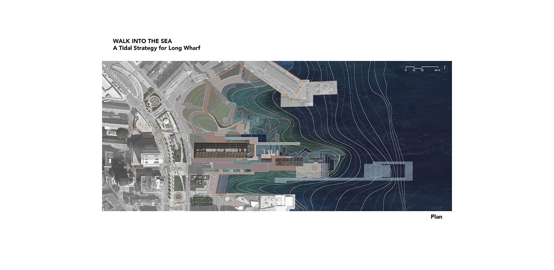
Walk Into the Sea

HONOR AWARD

GENERAL DESIGN

Boston, MA | Zhi Wang, Associate ASLA | Graduate | Faculty Advisor: Suzanne Mathew, Associate ASLA; Michael Blier, ASLA; Nick Depace; Colgate Searle, FASLA | Rhode Island School of Design

PROJECT STATEMENT

Because of the global sea-level rise, many old port cities are threatened by high tide and storm floods. The rich littoral culture and historical buildings also are in danger. Traditional seawalls or dikes will cut down the connection between urban activities and the coastal environment.

This design draws on Boston, Massachusetts, as an example of how to make use of the existing piers to develop a stormproof structure and to relieve the height of the structure to keep the expanding force of both urban growth and natural change.

There is a paradox in this design: The hard structure is softened; the seawall is permeable; and the designed structure is transparent, but the problem of sea-level rise is visible.

Different type of structures and height-relieving strategies are investigated as a prototype to use in other places. These strategies are also tested and applied on this specific site, the Long Wharf.

PROJECT NARRATIVE

The site is a group of piers sitting to the east of downtown Boston. The downtown was built on fill land that will be totally submerged by storm water in 2050 or high-tide water in 2100.

Depending on the existing contour, the structure needs to be 7 feet higher than the existing ground level, which will cut down the connection between urban activities and coastal environment. This design makes use of the pier area to build and relieve this 7-foot structure aiming to keep the urban and nature connection as well as prevent a storm flood.

This pier is a typical water-edge condition in Boston and has a very integral relationship with urban life. The Long Wharf is the oldest pier in Boston. It has witnessed the transformation of the city through the land fill process in the industrial period, the high-tech and commercial growth in industry, the decline and urban renewal period, and now the sea-level threat in this current ecological awareness period. The Long Wharf keeps the linear shape developed in 1768, the warehouse and Custom House Block built in 1848, while the Marriott Hotel mimics the industrial modularity and the Kennedy Greenway implies the revival awareness of reconnection to coastal environment. The previous function of the Long Wharf as a trading port and commercial place will now feature a new definition through this new transformation.

There is a push-pull relationship between urban and nature in Boston’s history. In the 19th century, when Boston relied on the trading port, the Long Wharf was the starting point of urban growth expanding inland. In the 20th century, when industry began to diminish, the renewed urban area expanded back onto the piers creating commercial and entertainment activities. Now in the 21st century, the period threatened by flood, piers renewal can be used as a solution. In my proposal, the Long Wharf will be a filter that will stop the flood, but allow the expanding force of both urban growth and natural change.

By studying flood-proof structures around the world, I summarized strategies that can lead people to walk and look out through the structure: Attractive programs and terraces can lead people to higher ground; temporal flood-proof structures can be transparent during a non-flood period; topography and floating structures can be used in the intertidal area to make the water edge more accessible; and an underwater museum can provide another interesting layer for the whole sequence.

Then, by discussing the infrastructure-edge condition and the relationship with water-level change, I found some ways to lead the natural phenomenon to get into the hard infrastructure and create hybrid structures of artificial and natural material. Monthly or daily flooded wetlands can be created by deliberately arranging the height of the ground level. Hard surfaces and wetlands can be mixed by using infrastructure-catching soils and sediments. Waves can be led up onto a hard surface by creating gentle sloping at the edge.

Sequences along this linear space can emphasis the experiential orientation. It changes from:

  1. A transition area with landscape urbanism park to
  2. An industrialized area with modular arrangement and artificial wetlands to
  3. The most hybrid area between hard infrastructure and intertidal wetlands to
  4. The plaza at the end of the wharf with a gentle slope letting water wash up and terraces stepping down into marshes, and finally to
  5. A floating deck leading to an underwater museum. Different plant communities are also arranged to emphasis this transition sequence.

Also, a conspicuous coastline change can make the push-pull relationship more visible. Therefore, the ground level is deliberately considered to change the height from the channel of -31 feet to the stormproof height of +21 feet.

All the studies about relieving the 7-foot-high structure and keeping the connection of urban activities and coastal environment provide a practicable background for showing the historical overlay and ecological education. It will imply a contrast of manmade infrastructure and natural environment, a contrast of entertainment atmosphere and terror of sea power, a contrast of the magnificence and vulnerability of human culture.

There is a walkway beginning at Quincy Market winding through the hybrid structure area and extending into deep water. It has an intimate relationship with a pleasant environment at the hybrid gathering space, and it turns narrow, deep and looks vulnerable when it extends further toward the sea. There is an underwater museum at the end of a floating deck. People will see the beautiful sea grasses and fishes while simultaneously seeing how fast and dynamic the water moves around them. There is a hybrid structure gathering space, which grows and changes by collecting sediments once a month. There is a sloped plaza at the end. The waves washing up make the boundary invisible and weaken the hard feeling of the infrastructure. There is a music pavilion and a gathering space that would be flooded once a month by the astronomical high tide. By making some pleasant places unusable some time, people can become aware of the rising sea level and how it really is changing their lives.

"This did not stop at the edge but took it further—topography, plants, existing features. Different from the hard edge approach to sites where water meets land."

- 2015 Awards Jury

PROJECT CREDITS

Kunyu Luo: Engineer consultant. Water force digital simulation