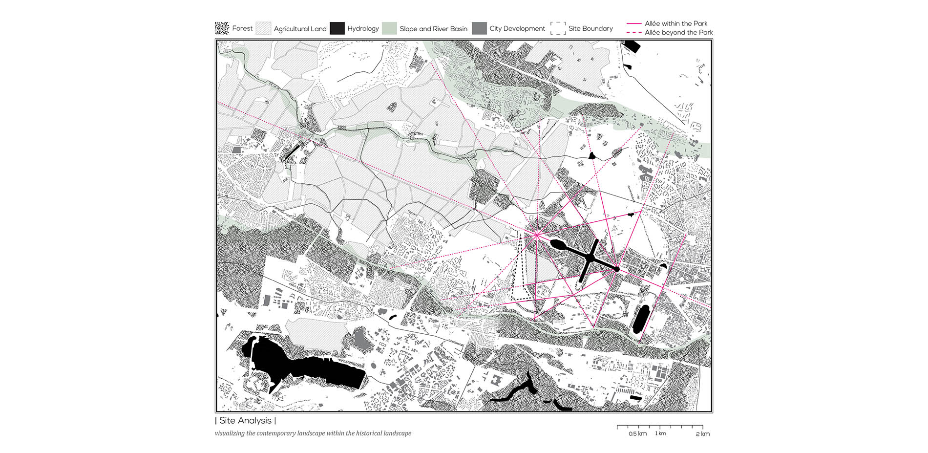
Imagine the Barracks of Pion: Developing the Edge of the Park of Versailles

AWARD OF EXCELLENCE

GENERAL DESIGN

Versailles, France | Zheming (Taro) Cai, Associate ASLA | Graduate | Faculty Advisor: Michel Desvigne, Inessa Hansch | Harvard University Graduate School of Design

PROJECT STATEMENT

While the preservation of historical landmarks has been made feasible and codified through organizations such as National Park Services and UNESCO, we sense the need of new approaches for commemoration. One may question the viability and the value of any act of preservation today due to the accelerated and contested nature of our society. How can we preserve the immaterial cultural significance and the sense of place through designing and preserving the physical environment? The project of developing Barracks of Pion, a formal military site at the edge of the Park of Versailles, attempts to provide critical conservation in urban development from a landscape perspective, in which the genius loci and the historical significance are articulated to support the understanding of the past, the present and the future.

PROJECT NARRATIVE

The Barracks of Pion, locates in the middle between the Park of Versailles and the city of Saint-Cyr, was previously occupied for military purposes. Today, the 50-acre site becomes the backyard of both Versailles and Saint-Cyr. With an elongate triangular shape, the site represents a hinge between the historical landscape and the urban territory. The project seeks new ways to confront conservational issues: to envisage the development as part of evolving continuity of historically significant landscape logic.

Creating Identity of Place in the Regional Scale

The analysis of Versailles reveals Le Notre’s axial allée system as a landscape framework that links between geography, hydrology, agrarian structures and urban forms in territorial scale. Furthermore, the framework in its axial expression did not merely represent monarchical power, but also demonstrated diverse ecological performances. The major axis essentially became a transect through various types of landscape and landscape performance. The system continues to play an important role today for anchoring a corridor for tourism. People are able to experience the past that still occurs today through visual acknowledgement of the spatial and morphological character of the geometry. Additionally, the system illustrates potentials to expand the tourism beyond the Versailles’s boundaries that is defined by UNESCO.
The axial allée system provides the framework to situate the project on a territorial scale, articulating the historical significance in the regional scale for conservation. Therefore, designing the site becomes creating the landscape within the landscape. It is no longer a matter of constructing a site from tabula rasa, but rather of working with existed genius of the place, representing and reinterpreting the character of the pre-existence.

Creating Identity of Place in the Site Scale

Versailles is often considered as the place of the invention of the classic city. My intuition to the project is to apply classical principles as a vernacular language, in order to design a coherent plan of creating two distinguished districts. My concept is to generate great contrast between mass and void with axial hierarchical alignment: Tree plantation constructs the framework to situate the design within Versailles’s historical landscape; two clearings are created within the framework, providing the voids for new development. Clearings from the early urbanization process can be seen as an extrusion of nature. However in this case, the clearing is an integral part of the regional landscape system. Additionally, each clearing provides opportunities to be designed as the prototype of urban forms. One clearing is designed as an urban area and the other one is designed as a residential area.

Plantation as Mega Structure

Four plantation typologies are designed and implemented on site, including the woodland plantation, the nursery plantation, the orchard plantation and the urban grove plantation. The different types of plantation provide great variations in species, physical morphology, spacing and seasonality. Therefore, the tree plantation does not only provide a physical link to the regional framework, but also as fundamentals in constructing the spatial programing and experiences in a site scale.

Residential Area

The concept is to design the networks of collective and public gardens as the framework for the residential area. The networks of gardens are connected through pedestrian paths, providing unique experiences for both the residences and the tourists, in which the difference of public and private becomes ambiguous in the field of gardens.

Urban Area

The urban area is built around the new proposed train station. Providing a station plaza, the urban area is able to perform as the social core for the surrounding communities, providing spaces for retail, restaurants and local events. The plaza is raised up to level with the arriving floor of the train station, offering the visitor an unobstructed view across the space and into Versailles.

Landscape Framework as Critical Conservation

The understanding and preservation of Le Notre’s axial allée system allows us to facilitate various place identities while maintain the coherence in a regional scale. The historical significance of Versailles is preserved through the articulation of the landscape framework. On the other hand, new developments are designed within the framework, filling the gap between the historical and contemporary landscape. The critical conservation through landscape framework does not retrofit static artifacts, but works to stabilize thresholds where potentials align.

"It’s housing created for the masses; we take it from the king, and give it back to the people. Revolutionary. Wonderfully crafted as a design."

- 2015 Awards Jury