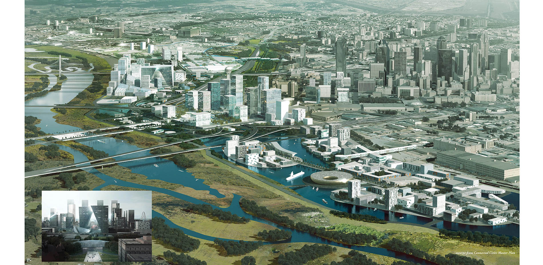
WATER-RICH SCHEME
Between Dallas and the Trinity River is an area dominated by highways and underdeveloped land, forming a moat that truncates and severs the downtown from the waterfront. This plan connects the two, and creates a vibrant linear city.
Photo Credit: OMA / MIA LEHRER + ASSOCIATES
Media: Please submit high-resolution image requests to images@asla.org.
LEADING THE WAY WITH WATER IN TEXAS
Droughts continue to plague Texas, and water is continually sourced from farther and farther away. Dallas is attempting to lead the state of Texas towards more aggressive water conservation and reuse strategies.
Photo Credit: OMA / MIA LEHRER + ASSOCIATES
Media: Please submit high-resolution image requests to images@asla.org.
RECONNECTING THE REGION TO WATER
The strategy for reconnecting Dallas to its river, and ultimately achieving resiliency from both flood and drought events, proposes a diverse and distributed range of water projects throughout the Trinity River Watershed.
Photo Credit: OMA / MIA LEHRER + ASSOCIATES
Media: Please submit high-resolution image requests to images@asla.org.
WATER & MOBILITY
Two new arc-shaped roads provide connections between downtown and the Trinity River. Within the loop roads, a grid of primary, secondary and tertiary streets build the framework for development of new properties along the levee and riverfront.
Photo Credit: OMA / MIA LEHRER + ASSOCIATES
Media: Please submit high-resolution image requests to images@asla.org.
HYDROLOGICAL SYSTEM
The hydrologic system is re-designed to relieve pressure on the Trinity Floodway and reduce risk of flooding by unearthing the Trinity River sub-basin and visibly capturing, treating and redirecting stormwater through the site.
Photo Credit: OMA / MIA LEHRER + ASSOCIATES
Media: Please submit high-resolution image requests to images@asla.org.
RIVER FLOODWAY PROCESSION
Daylighting and filtering existing watersheds and culverts reconstitutes the Old Trinity River, creating a new ecology that is the foundation for development, increasing property values and establishing a new, legible amenity zone adjacent to downtown.
Photo Credit: OMA / MIA LEHRER + ASSOCIATES
Media: Please submit high-resolution image requests to images@asla.org.
CREATING WATER EXPERIENCES
Various inflows of stormwater activate the urban area through uniquely designed water experiences. In combination with water treatment and habitat creation, this extensive system conveys, filters, stores, and eventually releases water back into the Trinity River Floodway.
Photo Credit: OMA / MIA LEHRER + ASSOCIATES
Media: Please submit high-resolution image requests to images@asla.org.
ENVIRONMENTAL, SOCIAL & ECONOMIC BENEFITS
Local ecology and public health is enhanced through improving water quality, reducing floods, restoring habitats, and improving pedestrian/bicycle circulation. Property values increase and maintenance costs associated with the levee and city stormwater decrease.
Photo Credit: OMA / MIA LEHRER + ASSOCIATES
Media: Please submit high-resolution image requests to images@asla.org.
TREATMENT PONDS
The implementation of treatment ponds focused on retention, detention and increased water quality incorporating bio-filtration and phytoremediation techniques are centered at ponding areas of increased volume of water catchment.
Photo Credit: OMA / MIA LEHRER + ASSOCIATES
Media: Please submit high-resolution image requests to images@asla.org.
RIPARIAN BUFFERS
As the volume of water gradually moves through the site and increases, riparian buffer strips and constructed wetlands are introduced to increase filtration while providing bank stabilization and aquatic and wildlife habitat.
Photo Credit: OMA / MIA LEHRER + ASSOCIATES
Media: Please submit high-resolution image requests to images@asla.org.
A CELEBRATION OF WATER
Stormwater runoff cascades through a series of runnels, creating a linear open space that parallels Main Street, the Trinity Arc, and Riverfront Boulevard. Intersections along Riverfront Boulevard become places for residents to gather and celebrate water.
Photo Credit: OMA / MIA LEHRER + ASSOCIATES
Media: Please submit high-resolution image requests to images@asla.org.