


Honor Award
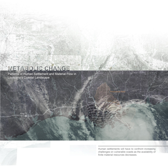
METABOLIC CHANGE: Coastal Patterns of Human Settlement and Material Flow
Eric Roy, Student Affiliate ASLA and Matthew Seibert, Student ASLA Graduate Louisiana State University
Faculty Advisors: Bradley Cantrell, ASLA; John White; Kristi Dykema and Jeff Carney
 Close Me!
Site Map
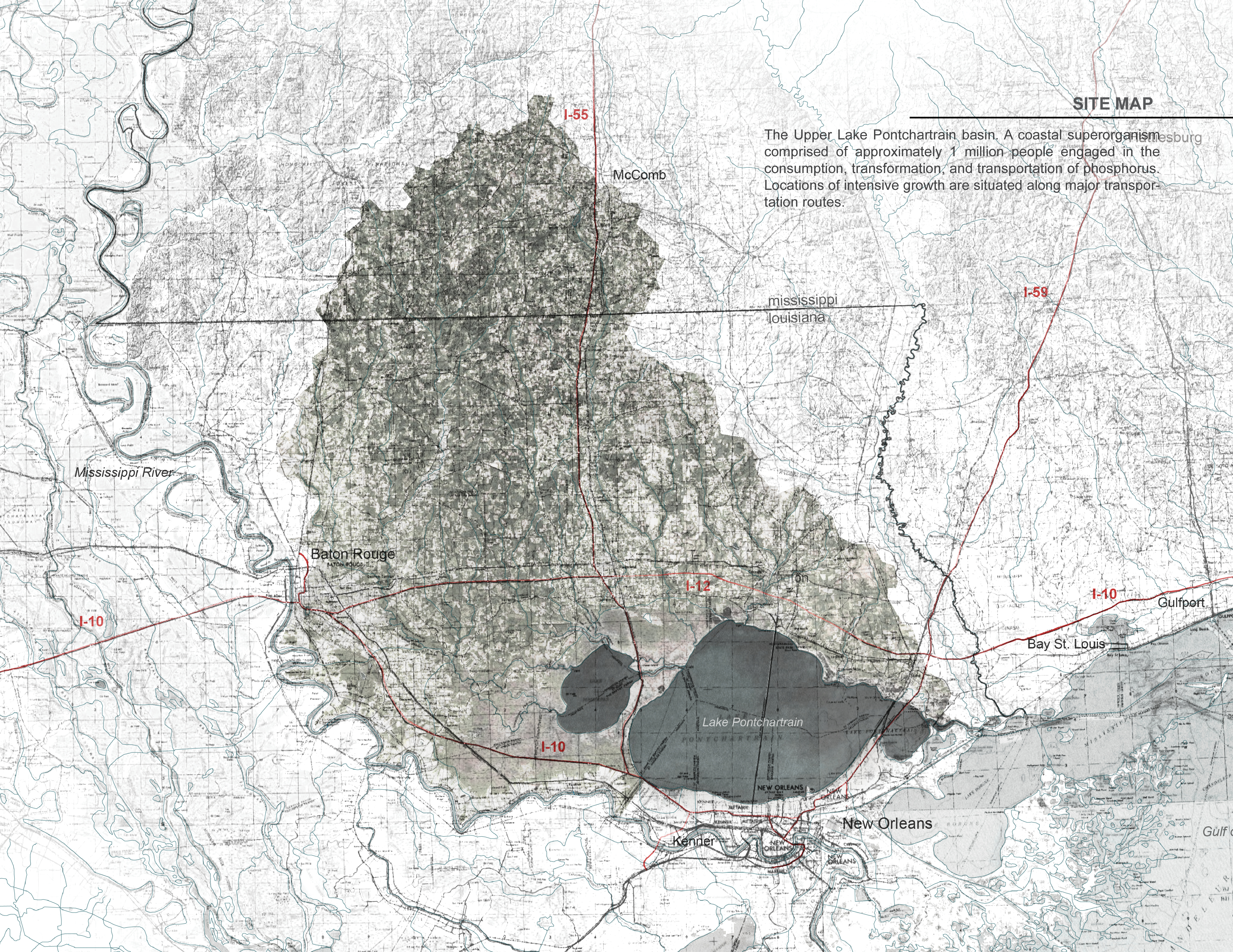
The Upper Lake Pontchartrain basin. A coastal superorganism comprised of approximately 1 million people engaged in the consumption, transformation, and transportation of phosphorus. Locations of intensive growth are situated along major transportation routes.
Download Hi-Res ImageImage: Matthew Siebert
Image 1 of 9
 Close Me!
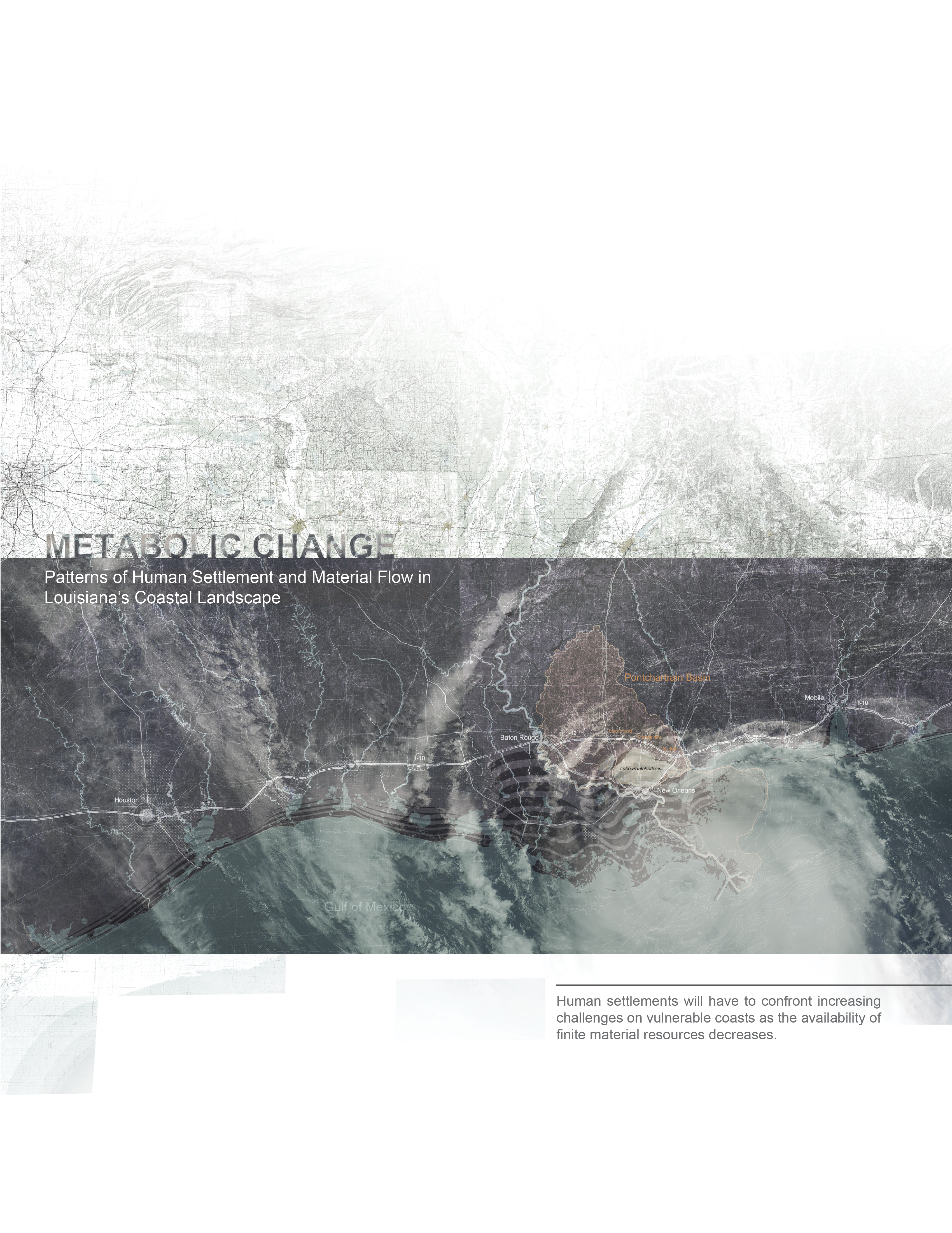
Human settlements will have to confront increasing challenges on vulnerable coasts as the availability of finite material resources decreases.
Download Hi-Res ImageImage: Matthew Siebert
Image 2 of 9
 Close Me!
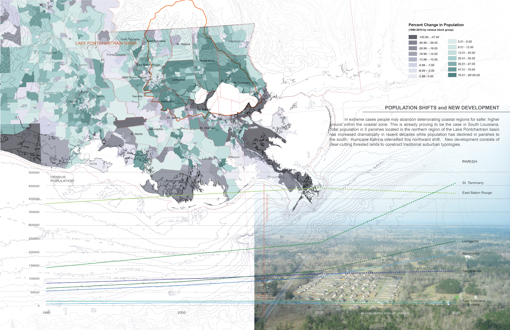
Population Shifts and New Development
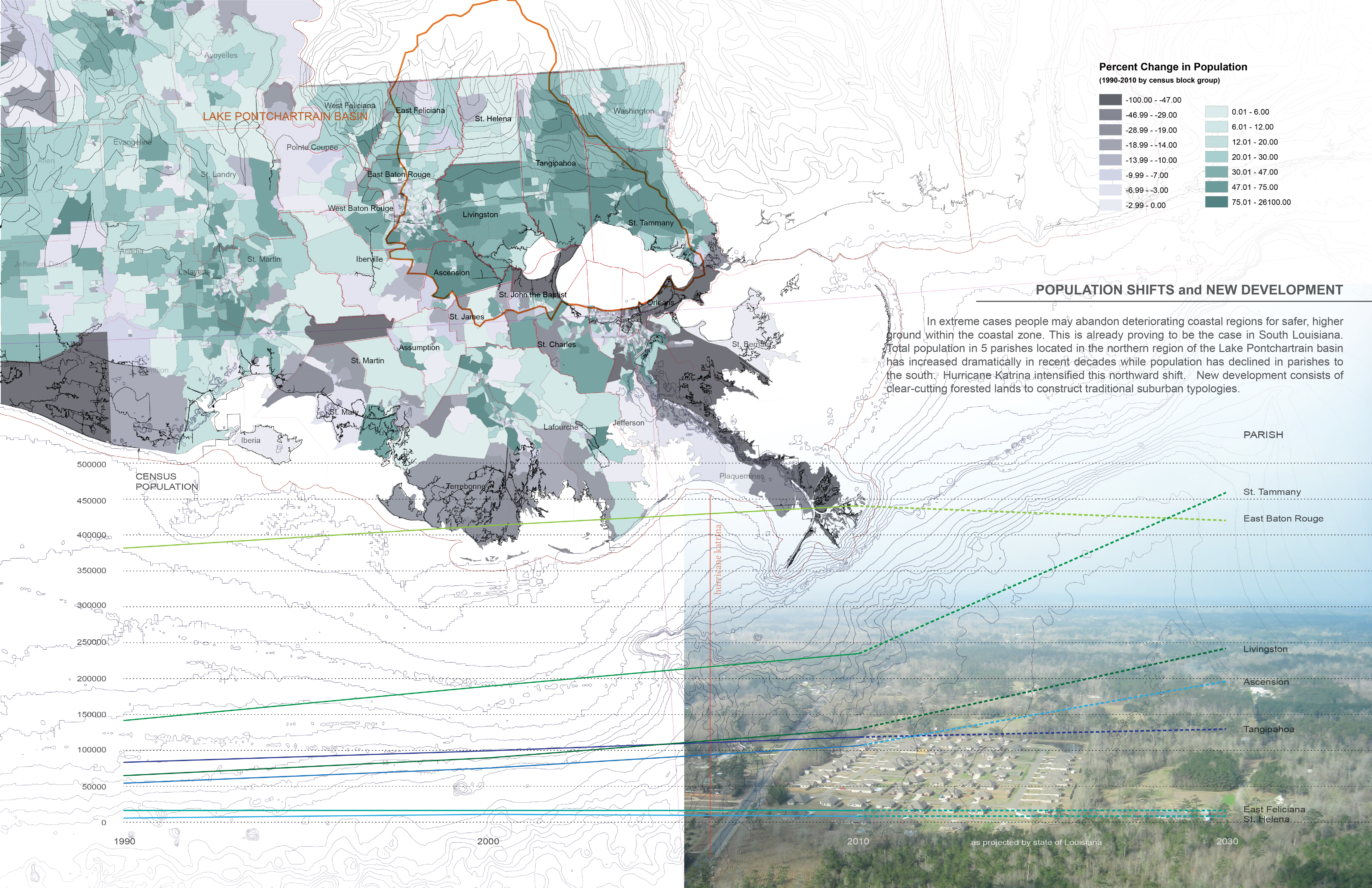
In extreme cases people may abandon deteriorating coastal regions for safer, higher ground within the coastal zone. This is already proving to be the case in South Louisiana. Total population in 5 parishes located in the northern region of the Lake Pontchartrain basin has increased dramatically in recent decades while population has declined in parishes to the south. Hurricane Katrina intensified this northward shift. New development consists of clear-cutting forested lands to construct traditional suburban typologies.
Download Hi-Res ImageImage: Matthew Siebert
Image 3 of 9
 Close Me!
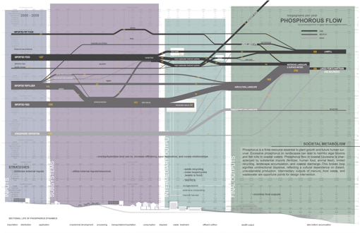
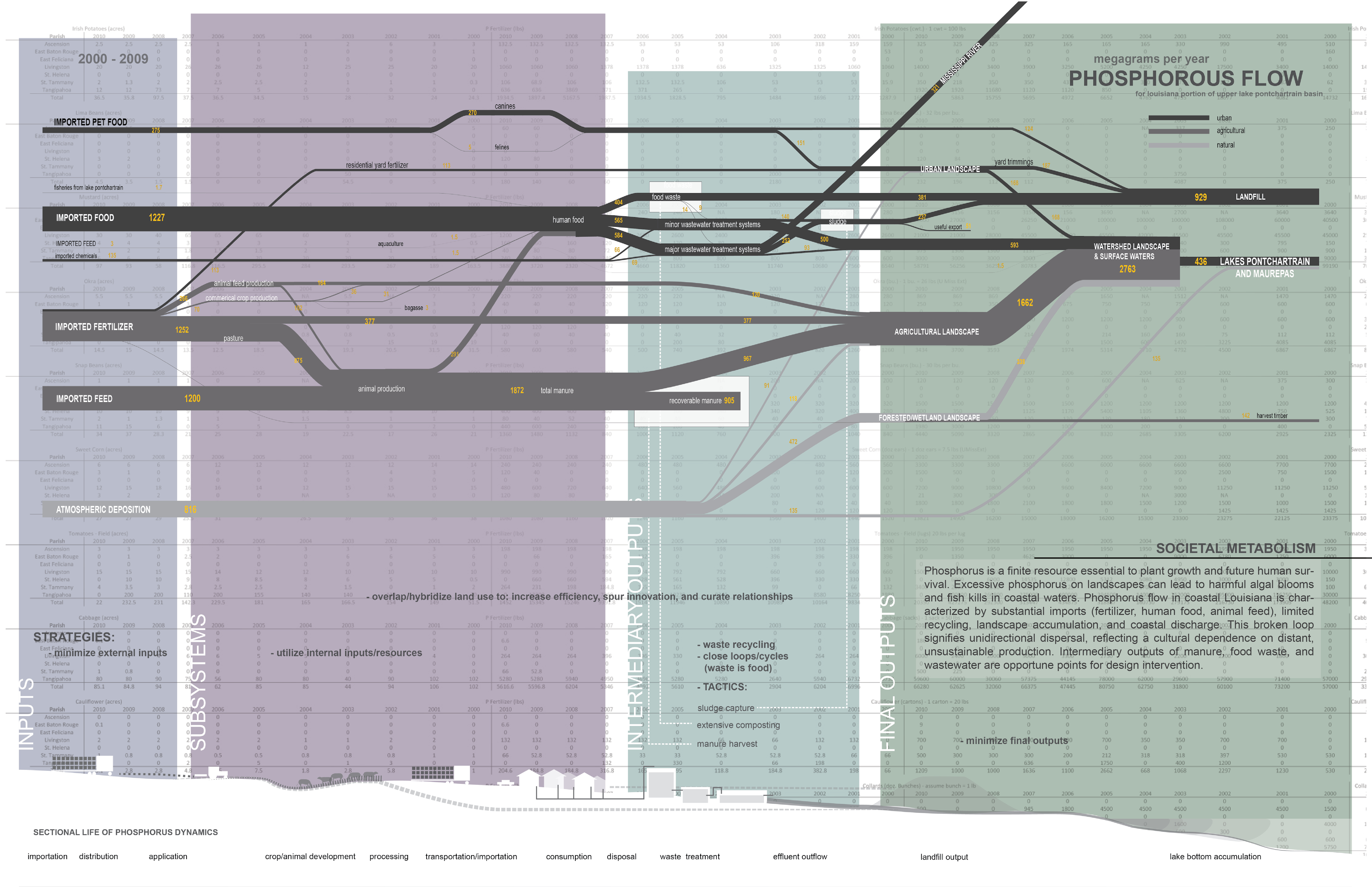
Societal Metabolism
Phosphorus is a finite resource essential to plant growth and future human survival. Excessive phosphorus on landscapes can lead to harmful algal blooms and fish kills in coastal waters. Phosphorus flow in coastal Louisiana is characterized by substantial imports (fertilizer, human food, animal feed), limited recycling, landscape accumulation, and coastal discharge. This broken loop signifies unidirectional dispersal, reflecting a cultural dependence on distant, unsustainable production. Intermediary outputs of manure, food waste, and wastewater are opportune points for design intervention.
Download Hi-Res ImageImage: Matthew Siebert
Image 4 of 9
 Close Me!
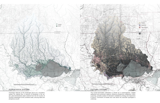
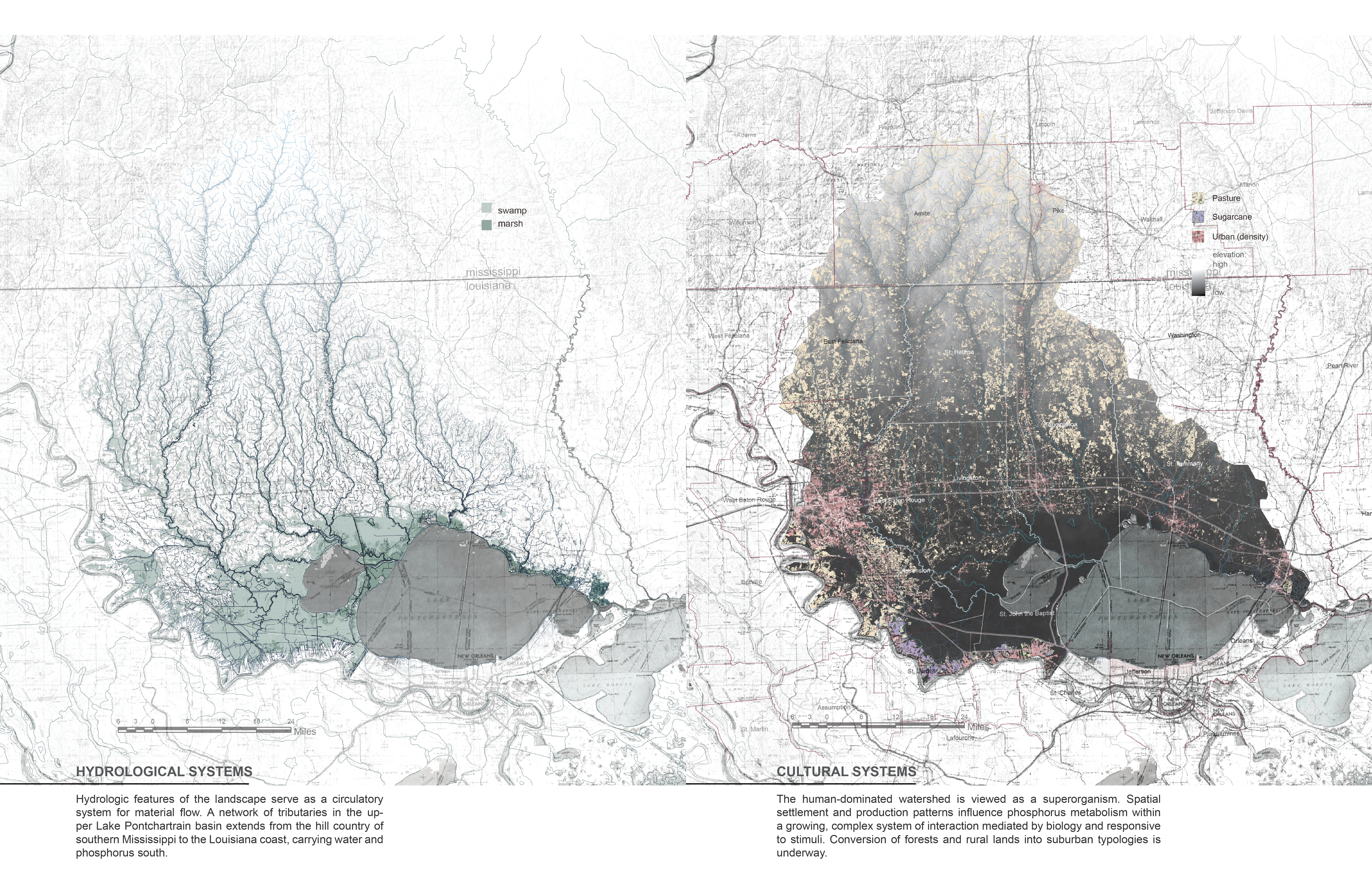
Hydrological Systems
Hydrologic features of the landscape serve as a circulatory system for material flow. A network of tributaries in the upper Lake Pontchartrain basin extends from the hill country of southern Mississippi to the Louisiana coast, carrying water and phosphorus south. Cultural Systems The human-dominated watershed is viewed as a super organism. Spatial settlement and production patterns influence phosphorus metabolism within a growing, complex system of interaction mediated by biology and responsive to stimuli. Conversion of forests and rural lands into suburban typologies is underway.
Download Hi-Res ImageImage: Matthew Siebert
Image 5 of 9
 Close Me!
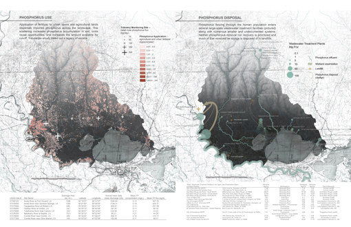
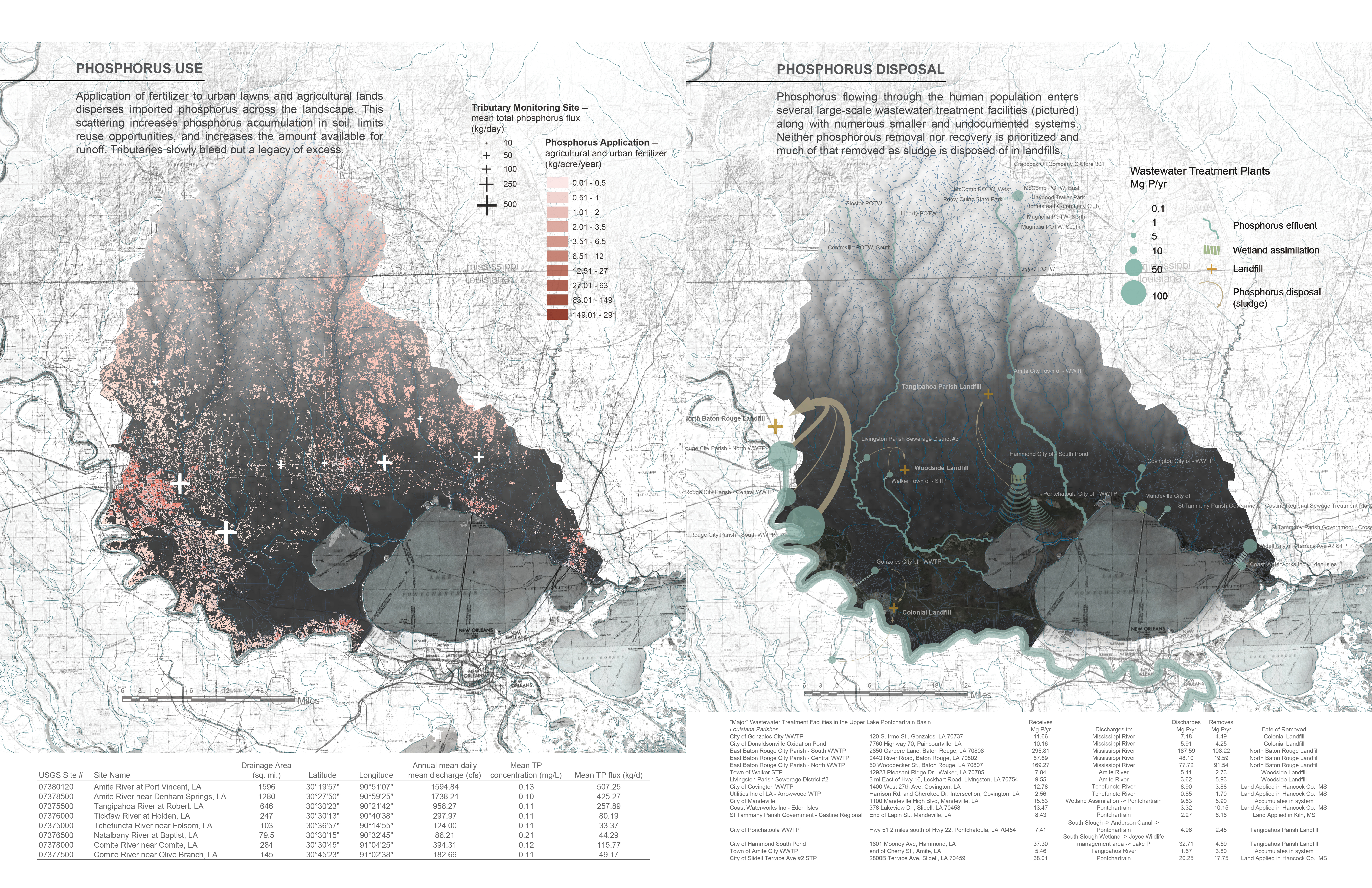
Left: PHOSPHORUS USE Application of fertilizer to urban lawns and agricultural lands disperses imported phosphorus across the landscape. This scattering increases phosphorus accumulation in soil, limits reuse opportunities, and increases the amount available for runoff. Tributaries slowly bleed out a legacy of excess. Right: PHOSPHORUS DISPOSAL Phosphorus flowing through the human population enters several large-scale wastewater treatment facilities (pictured) along with numerous smaller and undocumented systems. Neither phosphorous removal nor recovery is prioritized and much of that removed as sludge is disposed of in landfills.
Download Hi-Res ImageImage: Matthew Siebert
Image 6 of 9
 Close Me!
Phosphorus Use
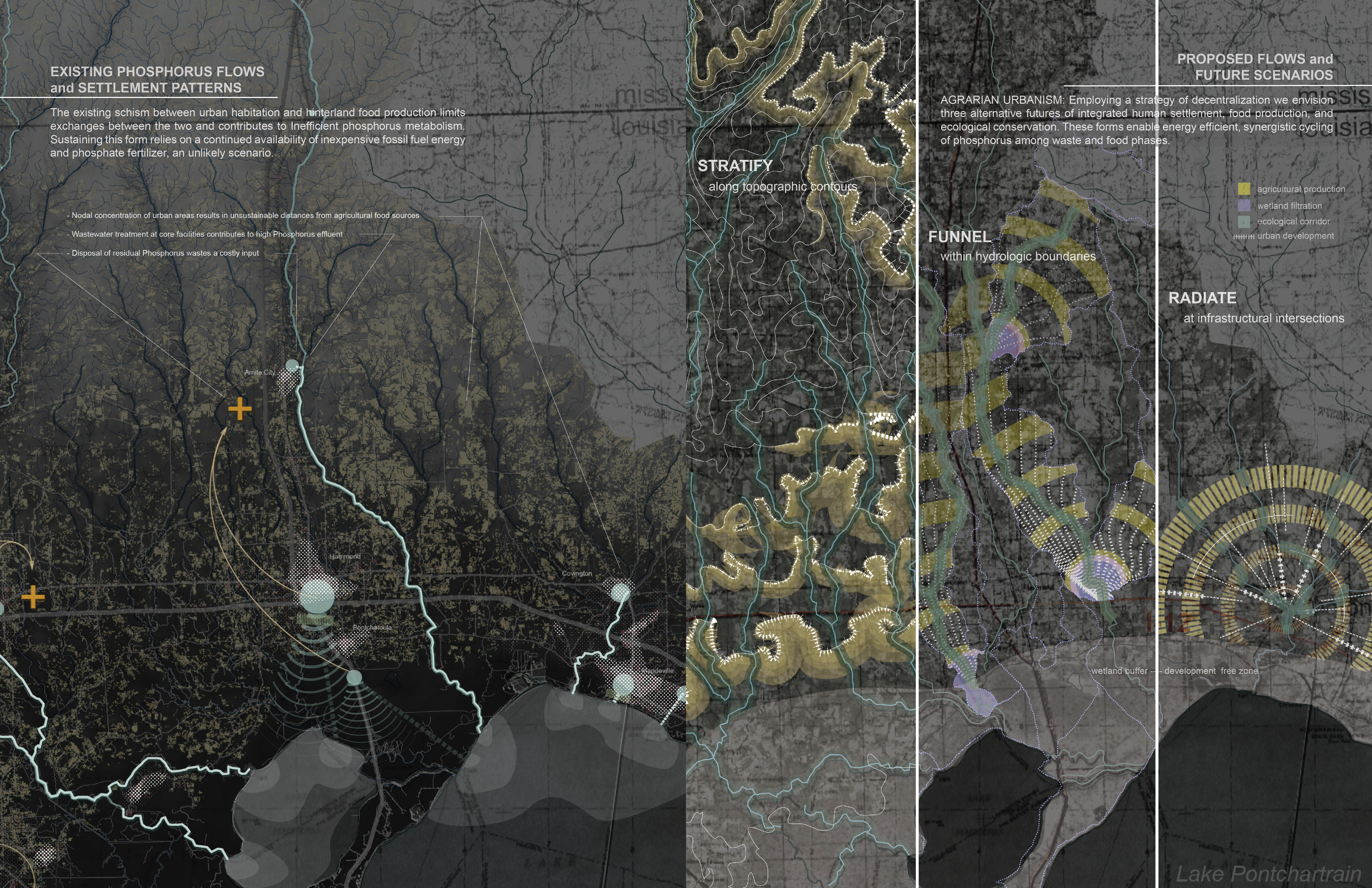
Left: EXISTING PHOSPHORUS FLOWS and SETTLEMENT PATTERNS The existing schism between urban habitation and hinterland food production limits exchanges between the two and contributes to Inefficient phosphorus metabolism. Sustaining this form relies on a continued availability of inexpensive fossil fuel energy and phosphate fertilizer, an unlikely scenario. Right: PROPOSED FLOWS and FUTURE SCENARIOS AGRARIAN URBANISM: Employing a strategy of decentralization we envision three alternative futures of integrated human settlement, food production, and ecological conservation. These forms enable energy efficient, synergistic cycling of phosphorus among waste and food phases.
Download Hi-Res ImageImage: Matthew Siebert
Image 7 of 9
 Close Me!
Phosphorus Disposal
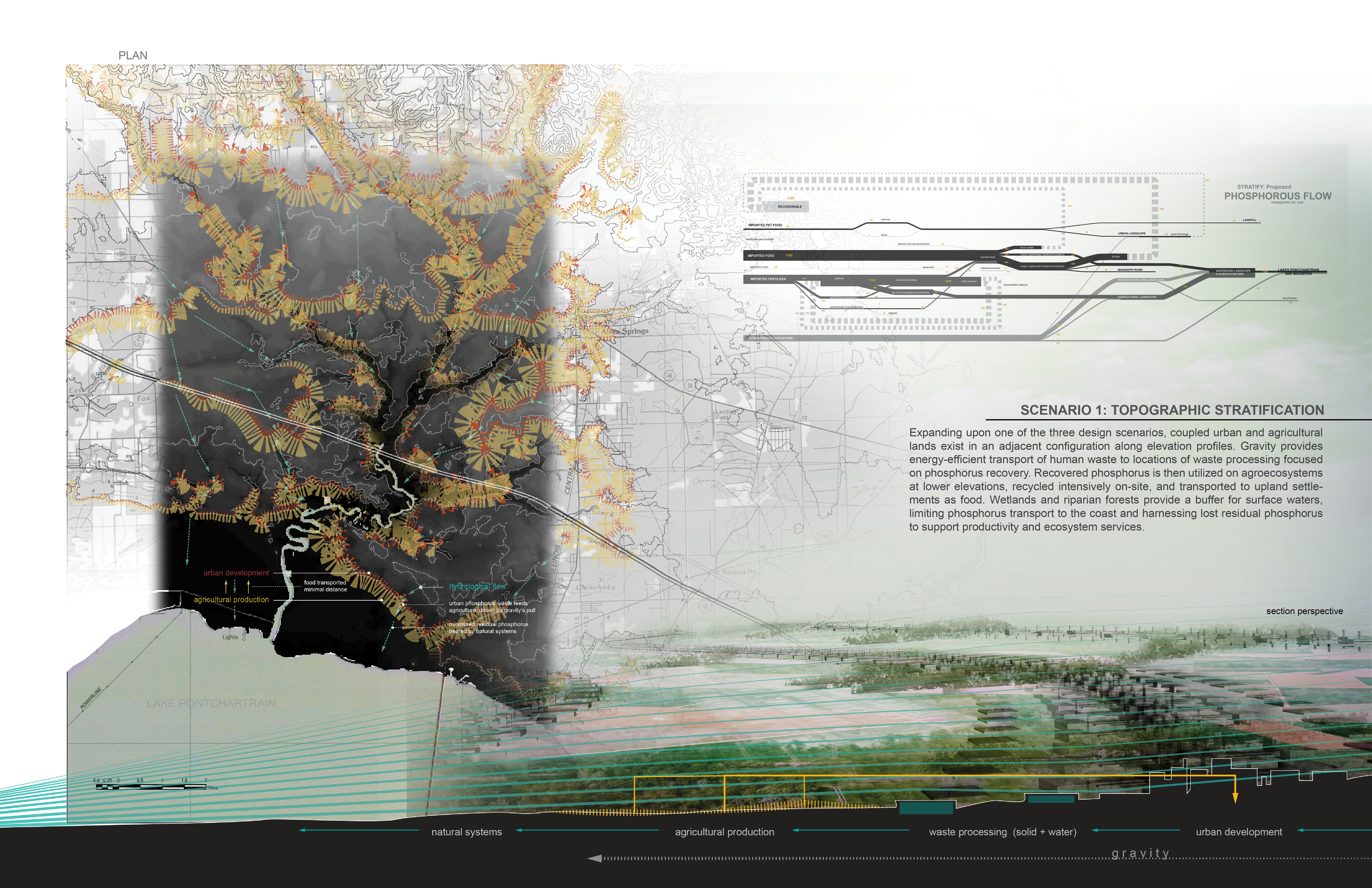
SCENARIO 1: TOPOGRAPHIC STRATIFICATION Expanding upon one of the three design scenarios, coupled urban and agricultural lands exist in an adjacent configuration along elevation profiles. Gravity provides energy-efficient transport of human waste to locations of waste processing focused on Phosphorus recovery. Recovered phosphorus is then utilized on agroecosystems at lower elevations, recycled intensively on-site, and transported to upland settlements as food. Wetlands and riparian forests provide a buffer for surface waters, limiting phosphorus transport to the coast and harnessing lost residual phosphorus to support productivity and ecosystem services.
Download Hi-Res ImageImage: Matthew Siebert
Image 8 of 9
 Close Me!
Existing Phosphorus Flows and Settlement Patterns
MONITORING THE SYSTEM Increasing public awareness is an essential task in the greater mission of improving society’s metabolism of phosphorus. By utilizing the intersections of infrastructure and hydrology a behavioral feedback system is realized. Light installations on bridges crossing tributaries communicate the level of phosphorus flux in the water flowing underneath, symbolizing phosphorus loss and pollution potential. Installations result in an increased legibility of material cycling, aiding in the adaptive management of a novel agrarian urbanism.
Download Hi-Res ImageImage: Matthew Siebert
Image 9 of 9
Project Statement
Metabolic Change investigates a coastal region experiencing population growth largely driven by environmental change as a burgeoning superorganism consuming, transforming, and expelling materials. The regional analysis and plan focuses on this superorganism’s metabolism of phosphorus, a finite resource essential to agricultural productivity and responsible for widespread aquatic pollution. The project integrates an analysis of phosphorus cycling grounded in systems ecology and engineering with a landscape architecture perspective on form to envision sustainable futures of an agrarian urbanism.
Project Narrative
Human communities are comprised of diverse individuals, but also function as a whole when it comes to the consumption, transformation, utilization, and expelling of material resources. Out of a meshwork of individual choices, cultural norms, regulations, land use, infrastructure, and technological practice emerges a superorganism with a quantifiable metabolism of materials. Metabolic Change takes this perspective into the coastal landscape.
In Louisiana, a migration of people from deteriorating regions to safer, higher ground is underway in the coastal zone and was punctuated by Hurricane Katrina. The sustainability of these growing coastal regions of refuge in a future characterized by a decreased availability of fossil fuels and material resources deserves increased attention. Metabolic Change focuses on the metabolism of phosphorus in the upper Lake Pontchartrain basin of southeast Louisiana where population is rising. Phosphorus is essential to human life as a key nutrient required for plant growth and a component of genetic molecules, cellular bioenergetics, and membranes. Phosphate rock is mined from places like Florida and Morocco, spread over the landscape as fertilizer, and transported through human communities as food and waste. Poor management of phosphorus leads to inefficient use and elevated discharge to aquatic ecosystems. This commonly results in negative ecological consequences including harmful algal blooms and fish kills. The paradox of phosphorus is that this widespread aquatic contaminant is also a finite resource forecasted to be in tight supply within decades. Improving society’s metabolism of phosphorus will be a critical task to ensure sustainability.
Analyzing and envisioning a growing coastal region as a superorganism requires an interdisciplinary approach combining ecology, engineering, spatial analysis, visualization, and design. Our two member team covered these diverse areas of inquiry and expression to formulate a perspective of unique scope. The challenge was to synthesize a large amount of data to effectively communicate current phosphorus flows, form a basis for design interventions, and envision creative solutions.
The analysis began with a massive data collection effort including census data, agricultural statistics, fertilizer sales records, tributary water quality data, tributary flow data, wastewater treatment permits, and multiple GIS layers, along with phosphorus concentration data for hundreds of foods, products, and waste streams. The Coastal Sciences team member used material flow analysis to track the movement of phosphorus through the upper Lake Pontchartrain basin, establishing a complex mass balance that was then visualized by the Landscape Architecture team member. The second phase of the analysis included an expansion of our understanding of how phosphorus moves through the system spatially based on current land use practices and mapping of collected data. Following these two analysis phases, we had generated a comprehensive view of how phosphorus enters the region, is transformed, utilized as food, and emitted as waste over time and space.
As we moved into the design phase, our discussions meandered through numerous practical limitations along with potential inspirations. For example, two key factors limiting the recycling of phosphorus in waste streams are energy availability and the distance between locations of waste phosphorus harvest and food production. How, then, should we implement design to navigate these limitations? Humans are not unique in their quest to obtain and recycle phosphorus. How do aquatic microorganisms maximize the efficiency of phosphorus use in phosphorus-limited environments? Thoughts such as these eventually led to concepts founded upon the notion of decentralization.
A counter-intuitive move towards decentralization brings many benefits. First, centralized wastewater systems rely upon large-scale, expensive infrastructure that may prove difficult to maintain in an energy-limited future and therefore a decentralized approach will be more adaptable and sustainable. Second, decentralization can increase the connectivity and overlap of urban space and agricultural production in comparison to when distinct separation exists between a centralized urban landscape and hinterland agriculture. The bodies of phytoplankton are commonly structured to maximize surface area, increasing the rate at which needed phosphorus diffuses in from the water. We are searching for ways to maximize the surface connecting people, wasted P, and food.
Three proposed phosphorus flow patterns for the future apply a strategy of agrarian urbanism: stratify, funnel, and radiate. The first employs topography as its driving feature, the second reorients political boundaries along hydrological watersheds, and the third capitalizes upon infrastructural junctions. In Metabolic Change, we elaborate on one of these proposals, exploring the potential for topographic stratification to guide the form of human settlement. Urban developments, waste harvesting sites, and productive agroecosystems are arranged in sequence along elevation gradients, providing gravitational transport of phosphorus-containing wastes and fertilizers. Enhanced recycling of waste phosphorus to food phosphorus would greatly increase overall metabolic efficiency, closing the human phosphorus cycle, and reducing the reliance on distant fossil fuel driven production systems. In addition, we believe increasing the legibility of these systems and their hidden processes is critical to both enhancing the efficiency of phosphorus metabolism in the region and supplying information for adaptive management of this metabolism. By exploiting the sites where infrastructure and hydrology cross, responsive light installations visualize phosphorus flux in the water and engage the public along high circulation conduits. This constructs a behavioral feedback system to inform local residents of the results of their collective actions and subsequently influence a community’s future development.
This project proposes a prosperous transition from a period of relatively cheap and widely available phosphorus fertilizer to one in which phosphorus availability is limited. The overarching metaphor of a superorganism metabolizing materials provides functional guidance and serves to inspire a shift in values, reconnecting residents to the land and highlighting their intimate role in global biogeochemical cycles.
Team Description
This project is part of a two year long collaboration between two graduate students. The team included one Landscape Architecture student who will be graduating with a masters degree this semester and one Coastal Sciences student who is in the final year of a PhD degree program and also has a background in engineering. The collaboration was born out of a series of conversations that took place within the study area during days on the beaches of the Comite River.
The Coastal Sciences student brought to the project an interest in how phosphorus flows through human communities and impacts the aquatic environment, prior ecological studies in Lake Pontchartrain, and experience using quantitative methods to understand complex systems. On its own, ecology is often a descriptive science, monitoring the impacts of human communities on ecosystems and essentially viewing cultural and built elements of a landscape as outside drivers. Landscape Architecture was needed to bring humans back into the ecosystem, to understand and communicate a dynamic network of phosphorus flows across the landscape that is a product of culture and design. The Landscape Architecture student began with an interest in coastal typologies subject to disturbance and responsive sustainability. His experience visualizing complex coastal dynamics at multiple scales was integral to our ability to synthesize an immense amount of data and communicate it effectively. Furthermore, moving from description to prescription was only possible given the Landscape Architecture student’s foundation in design. Both students contributed to data collection, while the Coastal Sciences student formulated and analyzed the regional phosphorus mass balance. The integration of quantitative ecology and landscape architecture allows for a strange brew of spreadsheets, metaphor, and visualizations that can greatly aid our ability to formulate visions for sustainable solutions that protect the environment while enriching human communities in times of change. The knowledge exchange between team members has been extensive and leaves each with a fuller perspective of what it means to be a human in a landscape.