


Honor Award
High Line, Section 2
New York City
James Corner Field Operations, New York City
Client: The City of New York and Friends of the High Line
 Close Me!
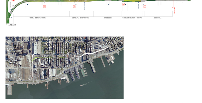
Site Plan
The High Line is a public park built on an historic freight rail line elevated above the streets on Manhattan's West Side. Running between Gansevoort and West 30th Streets, the High Line is now one mile in length.
Download Hi-Res ImageImage: James Corner Field Operations
Image 1 of 16
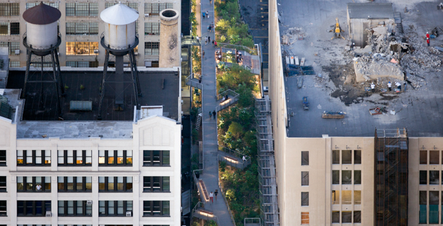
 Close Me!
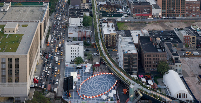
Aerial View Looking South
The first section of the High Line opened in June of 2009, the second section in June of 2011. That summer, a temporary beer garden and roller rink anchored the ground level on 30th Street.
Download Hi-Res ImageImage: Iwan Baan
Image 2 of 16
 Close Me!
Chelsea Thicket
As visitors move north from the Chelsea Grasslands' prairie-like landscape, a dense planting of flowering shrubs and small trees indicates the beginning of a new section of the park, between West 20th and West 22nd Streets.
Download Hi-Res ImageImage: Iwan Baan
Image 3 of 16
 Close Me!
Radial Bench
At West 29th Street, the High Line begins a long, gentle curve toward the Hudson River, signifying a transition to the West Side Rail Yards. A long wooden bench sweeps westward along the edge of the pathway.
Download Hi-Res ImageImage: Iwan Baan
Image 4 of 16
 Close Me!
23rd Street Lawn
At its northern end, the Lawn “peels up,” lifting visitors several feet into the air and offering views of Brooklyn to the east, and the Hudson River and New Jersey to the west.
Download Hi-Res ImageImage: Iwan Baan
Image 5 of 16
 Close Me!
Space for Public Art
Founded in 2009, High Line Art presents a wide array of artwork including site-specific commissions, exhibitions, performances, video programs, and a series of billboard interventions. Shown here is Sarah Sze's Still Life with Landscape (Model for a Habitat).
Download Hi-Res ImageImage: Iwan Baan
Image 6 of 16
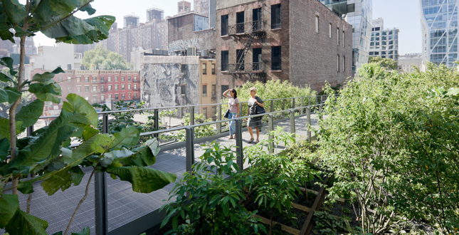
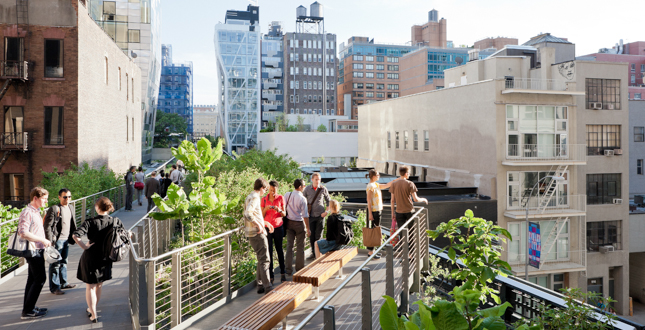 Close Me!
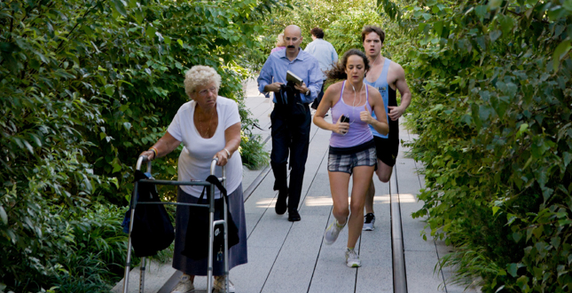
The Woodland Flyover
At various points, overlooks branch off the walkway, creating opportunities to pause and enjoy views of the plantings below and the city beyond.
Download Hi-Res ImageImage: Iwan Baan
Image 7 of 16
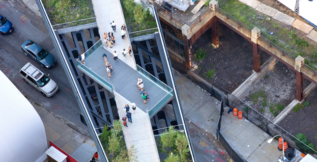
 Close Me!
Aerial View of The Woodland Flyover
A metal walkway rises eight feet above the High Line, allowing groundcover plants to blanket the undulating terrain below, and carrying visitors upward, into a canopy of sumac and magnolia trees.
Download Hi-Res ImageImage: Iwan Baan
Image 8 of 16
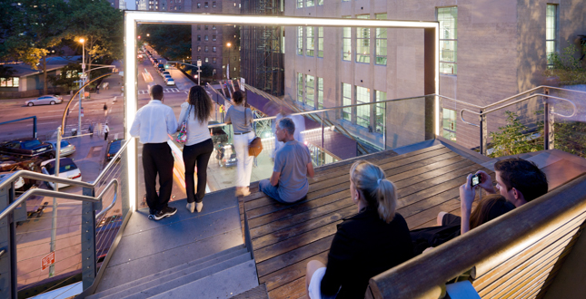 Close Me!
26th Street Viewing Spur
At West 26th Street, the Viewing Spur's frame enhances views of the city while recalling the billboards that were once attached to the High Line.
Download Hi-Res ImageImage: Iwan Baan
Image 9 of 16
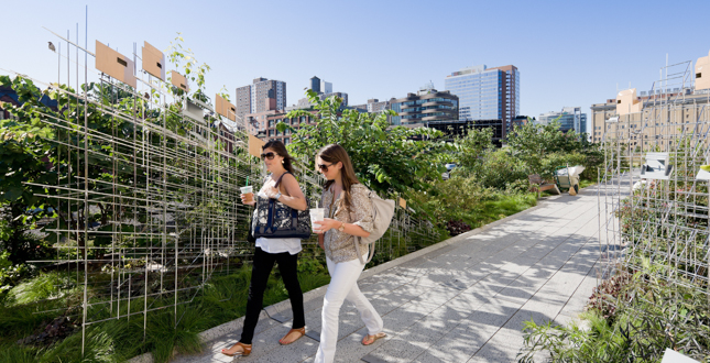
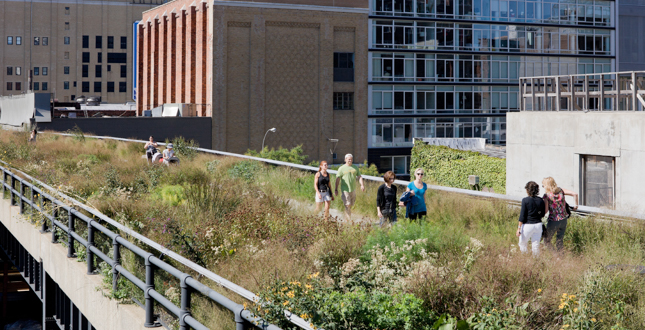 Close Me!
Chelsea Grasslands
Inspired by the self-sown landscape that grew on the High Line when the trains stopped running, the High Line design team filled the Chelsea Grasslands with wild grasses and vibrant wildflowers that add color and texture throughout four seasons.
Download Hi-Res ImageImage: Iwan Baan
Image 10 of 16
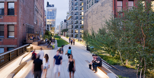
 Close Me!
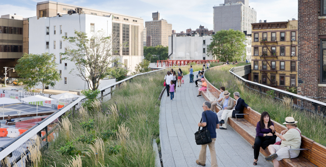
Wildflower Field
The simplicity of the straight walkway, running alongside the wildflowers interspersed between the original railroad tracks, allows visitors to appreciate the green axis of the High Line, as it moves through the city.
Download Hi-Res ImageImage: Iwan Baan
Image 11 of 16
 Close Me!
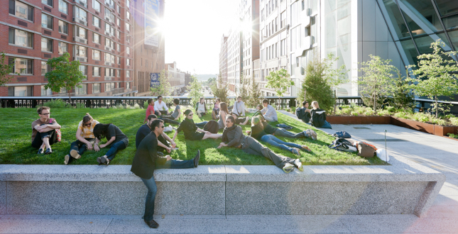
23rd Street Lawn and Seating Steps
The extra width in this area was used to create a gathering space, with Seating Steps made of reclaimed teak anchoring the southern end of a 4,900-square-foot lawn.
Download Hi-Res ImageImage: Iwan Baan
Image 12 of 16
 Close Me!
The Woodland Flyover
A metal walkway rises eight feet above the High Line, allowing groundcover plants to blanket the undulating terrain below, and carrying visitors upward, into a canopy of trees.
Download Hi-Res ImageImage: Iwan Baan
Image 13 of 16
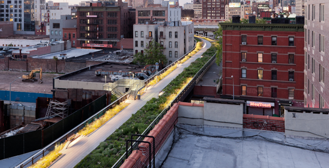
 Close Me!
30th Street Cut-Out and Viewing Platform
Near the northern terminus of Section 2 the concrete decking has been removed, showcasing the strength of the High Line's steel frame.
Download Hi-Res ImageImage: Iwan Baan
Image 14 of 16
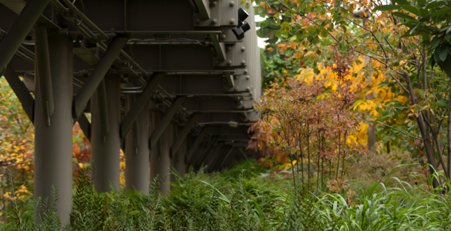 Close Me!
Planting View Under the Flyover
The High Line has a continually changing palette of plants. It rewards repeat visits in all seasons with its huge range of colors, textures and relationships.
Download Hi-Res ImageImage: Casual Capture
Image 15 of 16
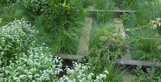 Close Me!
Planting
The plantings emphasize diversity in bloom times, with plants blooming from late January to mid-November. The High Line has an extraordinary number and diversity of plants, which create a rich habitat for insects and birds and a rich experience for visitors.
Download Hi-Res ImageImage: Mercer County Master Gardeners
Image 16 of 16
Project Statement
The High Line is an elevated railroad reclaimed as an extraordinary public space, a connector of neighborhoods and a new model for the ‘greening' of the urban environment. It is creating a new way of seeing the city, is recognized as an icon for innovative design and sustainability and is an inspiration to other cities - proof of the dramatic change that landscape architecture can have on the quality of life in cities.
Project Narrative
—2013 Professional Awards Jury
Site and Context
The High Line spans over twenty-three city blocks on Manhattan's West Side, connecting and interacting with 3 distinctive neighborhoods: the Meatpacking District, West Chelsea, and Hell's Kitchen/Clinton. It was built in the 1930's as part of the West Side Improvement Project to lift freight traffic in the air, removing dangerous trains from the streets below. Left unused since 1980, the line was considered an eyesore in the neighborhood and was under threat of demolition. During that time an opportunistic landscape began to grow, capturing the imagination of a few New Yorkers and triggering the idea for its conversion into a park. In 1999, the Friends of the High Line formed with the mission to save the High Line and transform it into an extraordinary public park. The High Line Park is now built, owned by the City of New York, and maintained and operated by Friends of the High Line. Section 1 opened in June of 2009, from Gansevoort Street to 20th Street (9 blocks). Section 2 opened in June of 2011, from 20th Street to 30th Street (10 blocks), doubling the length of the park to 1 mile in length. The popularity of the first section far exceeded everyone's expectations, so a challenge for Section 2 was to live up to this promise, build upon its identity and success and create something new and exciting. The site itself provided the inspiration. Section 2 has its own distinct identity as it moves north from 20th Street in West Chelsea to the beginning of the West Side Rail Yards at 30th Street. It is narrower and straighter, bounded on both sides by an eclectic mix of historic warehouses, residential buildings and new development. The scale is much more intimate, intense, even voyeuristic, creating a feeling of being more removed from the big city and more immersed in the neighborhood.
Truly Sustainable
As an ambitious urban reclamation project, the High Line's very essence is born out of the desire to preserve and recycle. It is significant and meaningful as a project that is politically, ecologically, historically, socially, and economically sustainable. Politically as a testament to community activism, saved by 2 neighborhood residents; Ecologically as a 6-acre green roof in the middle of the city; Historically as a retrofit project, transforming an abandoned rail line into a new public space; Socially as both a neighborhood and world-class park, where families, tourists, and the community meet and socialize; and Economically as an entrepreneurial effort that has demonstrated the ability of public spaces to generate revenue, attract businesses, and stimulate local economic growth. Section 2 transforms half a mile of infrastructure into parkland, reducing the heat island effect and creating significant habitat. Over 300 species were carefully selected to produce a primarily native landscape working with specific environmental conditions. Green-roof technologies along with open joint pavement enhance water retention, drainage and aeration and minimize irrigation requirements. Recycled materials are promoted including reclaimed wood, recycled steel and local aggregate for precast concrete. The park is lit with energy-efficient LED lighting, local and sustainably grown food is promoted at concession stands and a variety of free educational programs are offered to the community.
Why the High Line Is Unique
The High Line's relationship to the City is what makes it so powerful and unique. It is a consistent transect through a varied city landscape. The mix of building types and how they meet the High Line, along with the intimate choreography of the pathways directed towards views of the Hudson River, neighborhood streets and iconic city monuments is an authentic New York experience and part of what makes it so appealing. It is a journey, in addition to a place, and has thus reintroduced the notion of ‘promenading' back into the urban park experience. Elevated 30 feet above the ground, the High Line provides a unique urban experience; where one is both a part of the City and removed from the City at the same time. In contrast to being envisioned primarily as an ‘escape' from the City, the High Line design uses the City for inspiration and exchange. Even New Yorkers familiar with their surroundings, come up onto the High Line and see their city in a new and unexpected way.
Design Intent
It has always been our position to respect the innate character of the High Line itself; to capitalize on what is already there and to "grow" something new out of something old. The mantra throughout the design process was ‘‘Keep it Simple, Keep it Wild, Keep it Slow, and Keep it Quiet'. The intent was not to overdesign the park with elaborate interventions, but rather intensify the existing context and design it as an immersive experience, episodic walk and surreal journey in the City. In this project, preservation and innovation come together through the adaptive reuse of the existing structure as a new, compelling, one-of-a kind recreational amenity and public promenade.
Materials
The High Line's past as both a working railroad and abandoned landscape are reflected in the design through the use of industrial and robust materials (concrete, weathered steel, reclaimed wood); the selection and arrangement of grasses and perennials to further define a wild and dynamic landscape; the integration of historical artifacts such as reinstalled rail tracks and switches; and the preservation and exposure of the existing structure at features, access points and cross streets. When observed in the context of the new park, these features allow for a fresh interpretation of the site. Designed as an integrated system, the High Line's plantings, furnishing, paving, lighting and utilities were conceived and built as one system, working together within the limited width and depth of the structure itself. The signature paving is an innovative technology in as much as it is a walking surface; built from individual concrete planks with open joints and specially tapered edges and seams that integrate planting and rail tracks, permit the free flow of water, direct water to planting beds and minimize irrigation requirements. The custom designed ‘peel-up' bench grows out of the paving, rising to form an elegant cantilevered bench oriented towards particular views or arranged for increased sociability. In Section 2, the simplicity in design material and basic design elements remain consistent with Section 1, with some subtle surprises that expand upon the High Line ‘DNA', such as embedding the rail tracks directly into the paving system or introducing the only lawn in the park.
A Walk in the Park
Unique site conditions are further emphasized through a sequence of distinctive rooms along Section 2, including the Thicket, the Seating Steps + Lawn, the Woodland Flyover + Viewing Spur, the Wildflower Field, the Radial Bench and the Cut-out. In the ‘Thicket', between 20th and 22nd Streets, a dense planting of flowering shrubs and small trees indicates the beginning of a new section of the park, creating an enclosure and gateway into the residential neighborhood of West Chelsea. At 22nd Street, the ‘Seating Steps' are used for a range of activities including impromptu performances, family picnics, romantic outdoor dinners, art classes and sunbathing. A 4,900-square-foot lawn “peels up” over 23rd Street, lifting visitors several feet into the air and offering views from river to river. In the ‘Woodland Flyover,' between 25th and 26th Streets, a metal walkway rises 8 feet above the High Line, allowing plants to grow underneath while carrying visitors into a canopy of trees. Overlooks branch off the walkway, including the 26th Street Viewing Spur whose frame enhances views of the city while recalling the billboards that were once there. The ‘Wildflower Field' between 26th and 29th Streets, is dominated by hardy, drought-resistance grasses and perennials with variation in blooms throughout the year. At 29th Street, the High Line begins a long, gentle curve toward the Hudson River, echoed by a nearly 1-block long ‘Radial Bench'. At the northern terminus of Section 2, the pathway slowly rises above an area where the concrete decking has been removed, showcasing the existing structure. A viewing platform hovers above this ‘Cut-Out', creating a surreal moment where visitors can peer down through the structure to the traffic below on 30th Street.
Impact and Inspiration
Recognized as a significant contributor in the revitalization of Manhattan's West Side, the High Line has become a defining feature in its neighborhood and a powerful catalyst for investment. In 2005, the City rezoned the area around the High Line to encourage development while protecting the neighborhood character. The combination of the rezoning and the success of the park have helped to create one of the fastest growing and most vibrant neighborhoods in NYC, with a population increase of more than 60 percent in the last 10 years. Since 2006, new building permits around the High Line doubled and at least 29 major development projects have been initiated (19 completed, 10 underway) accounting for more than $2 billion in private investment including 12,000 new jobs. Construction has begun on a new downtown home for the Whitney Museum of American Art, which will serve as a major cultural anchor at the southern end of the High Line. The design of the park is iconic and specific to its place – this authenticity has generated a loyal group of supporters and devoted fans and has inspired other cities to investigate the feasibility of replicating it in their cities.
Project Resources
Lead Designer
James Corner Field Operations (project Lead) and Diller Scofidio & Renfro and Piet Oudolf
Landscape Architect of Record
James Corner Field Operations
Design Team (2004-present)
James Corner Field Operations (project lead) and Diller Scofidio + Renfro and Piet Oudolf
James Corner Field Operations (Project Lead)
Principal-in-Charge
James Corner, ASLA
Lead Project Designers
Lisa Tziona Switkin
Nahyun Hwang
Project Team
Sierra Bainbridge
Elizabeth Fain
Tom Jost
Danilo Martic
Tatiana von Preussen
Maura Rockcastle, ASLA
Lara Shihab-Eldin
Heeyeun Yoon
Hong Zhou
Karen Tamir
Diller Scofidio + Renfro
Partners
Elizabeth Diller
Ricardo Scofidio
Charles Renfro
Project Designer
Matthew Johnson
Project Team
Robert Condo
Tobias Hegemann
Gaspar Libedinsky
Jeremy Linzee
Miles Nelligan
Dan Sakai
Structural / MEP Engineering
Buro Happold
Principal
Craig Schwitter
Team
Herbert Browne
Dennis Burton
Andrew Coats
Anthony Curiale
Mark Dawson
Beth Macri
Sean O'Neill
Stan Wojnowski
Zac Braun
David Bentley
Elizabeth Devendorf
Alan Jackson
Christian Forero
Joseph Vassilatos
Edward Falsetto
Stuart Bridgett
Michael McGough
Structural Engineering/ Historic Preservation
Robert Silman Associates
Joseph Tortorella
Andre Georges
Planting Specialist
Piet Oudolf
Lighting
L'Observatoire International
Hervé Descottes
Annette Goderbauer
Jeff Beck
Jason Neches
Signage
Pentagram Design, Inc
Paula Scher
Drew Freeman
Rion Byrd
Jennifer Rittner
Irrigation
Northern Designs
Michael Astram
Environmental Engineering / Site Remediation
GRB Services, Inc.
Richard Barbour
Steven Panter
Rose Russo
Civil & Traffic Engineering
Philip Habib & Associates
Philip Habib
Sandy Pae
Colleen Sheridan
Soil Science
Pine & Swallow Associates, Inc.
John Swallow
Robert Pine
Mike Agonis
Public Space Management
ETM Associates
Tim Marshall
Water Feature Engineering
CMS Collaborative
Edison Becker Bonjardim
Roy Kaplan
Tanya Larson
Cost Estimating
VJ Associates
Vijay Desai
Sushma Tammareddi
Chongba Sherpa
Code Consulting
Code Consultants Professional Engineers
John McCormick
Laurence J. Dallaire
Kevin Morin
Surveying
Control Point Associates, Inc.
Paul Jurkowski
Eneser Enerio
Expediting
KM Associates
Joe Ganci
Section 2 Construction Team
Resident Engineer
HDR + LiRo/Jim Eckhoff
Landscape Construction Management
SiteWorks
Annette Wilkus, ASLA
Martin Leibrock, ASLA
General Contractor
CAC
Community Liaison
Helen Neuhaus & Associates
Construction Management
Bovis Lend Lease