


Honor Award
Network-Landscapes — New Control Options for Landscape Architecture and Environmental Planning
Alexander Dunkel, Student ASLA, Graduate,University of California, Berkeley
Faculty Advisors: Dr. Mona El Khafif; Dr. Catrin Schmidt; and Judith Stilgenbauer
 Close Me!
Theoretical background and mapping of raw data.
Download Hi-Res ImageImage: Alexander Dunkel
Image 2 of 15
 Close Me!
Steps of processing data to identify individual locations of interest.
Download Hi-Res ImageImage: Alexander Dunkel
Image 3 of 15
 Close Me!
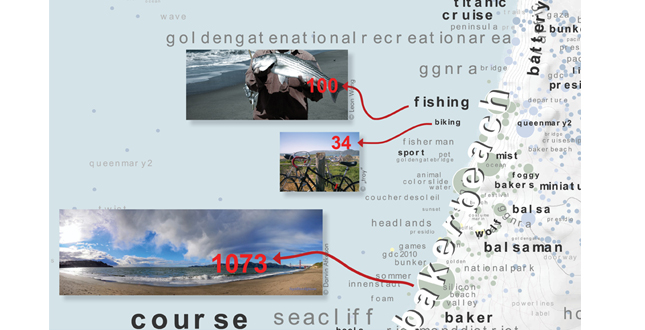
Location based labeling using tag occurrences.
Download Hi-Res ImageImage: Alexander Dunkel
Image 5 of 15
 Close Me!
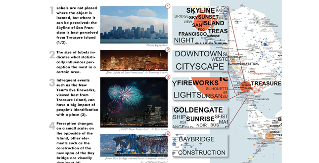
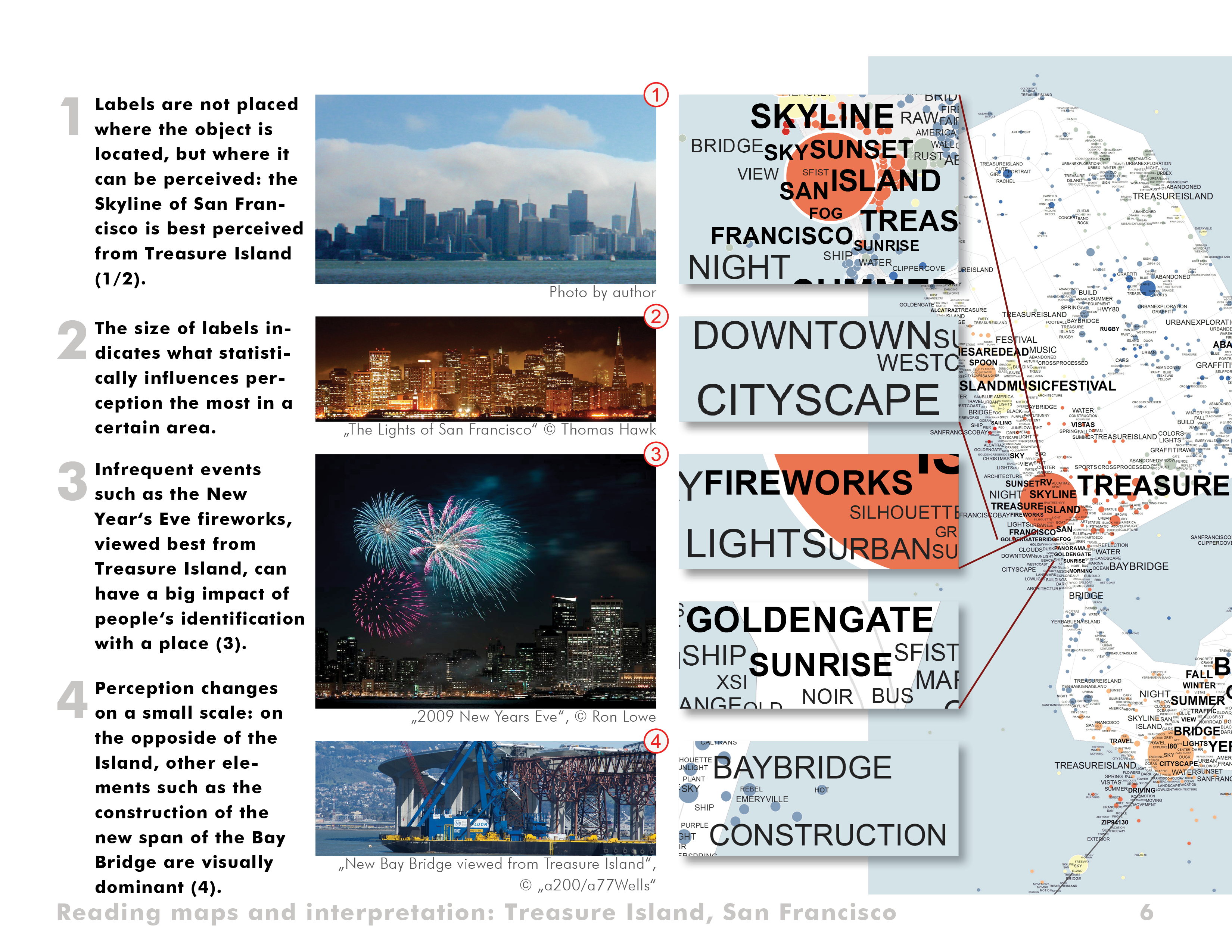
Reading maps and interpretation: Treasure Island, San Francisco.
Download Hi-Res ImageImage: Alexander Dunkel
Image 6 of 15
 Close Me!
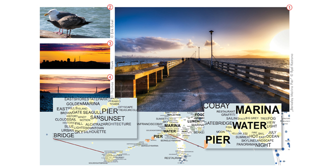
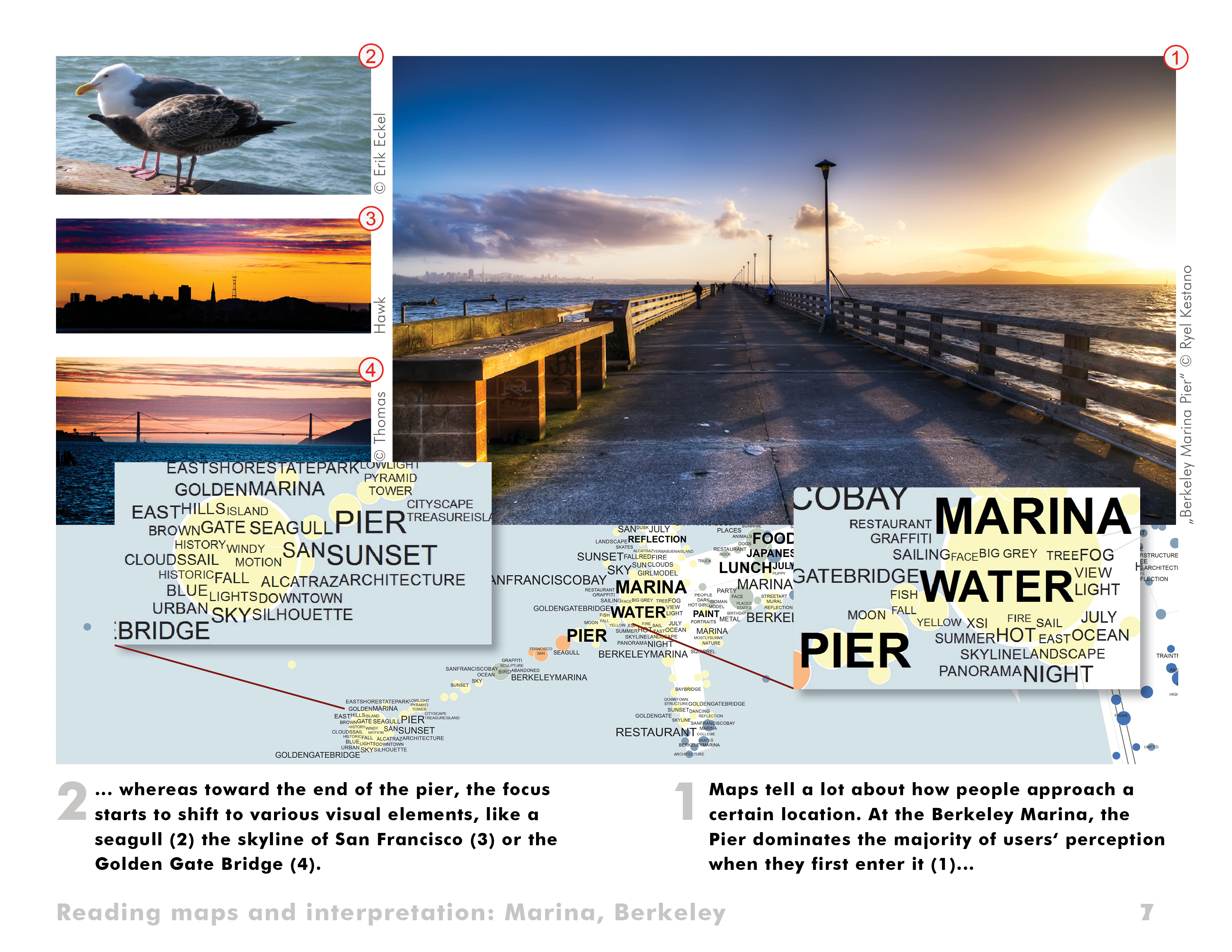
Reading maps and interpretation: Marina, Berkeley.
Download Hi-Res ImageImage: Alexander Dunkel
Image 7 of 15
 Close Me!
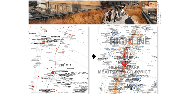
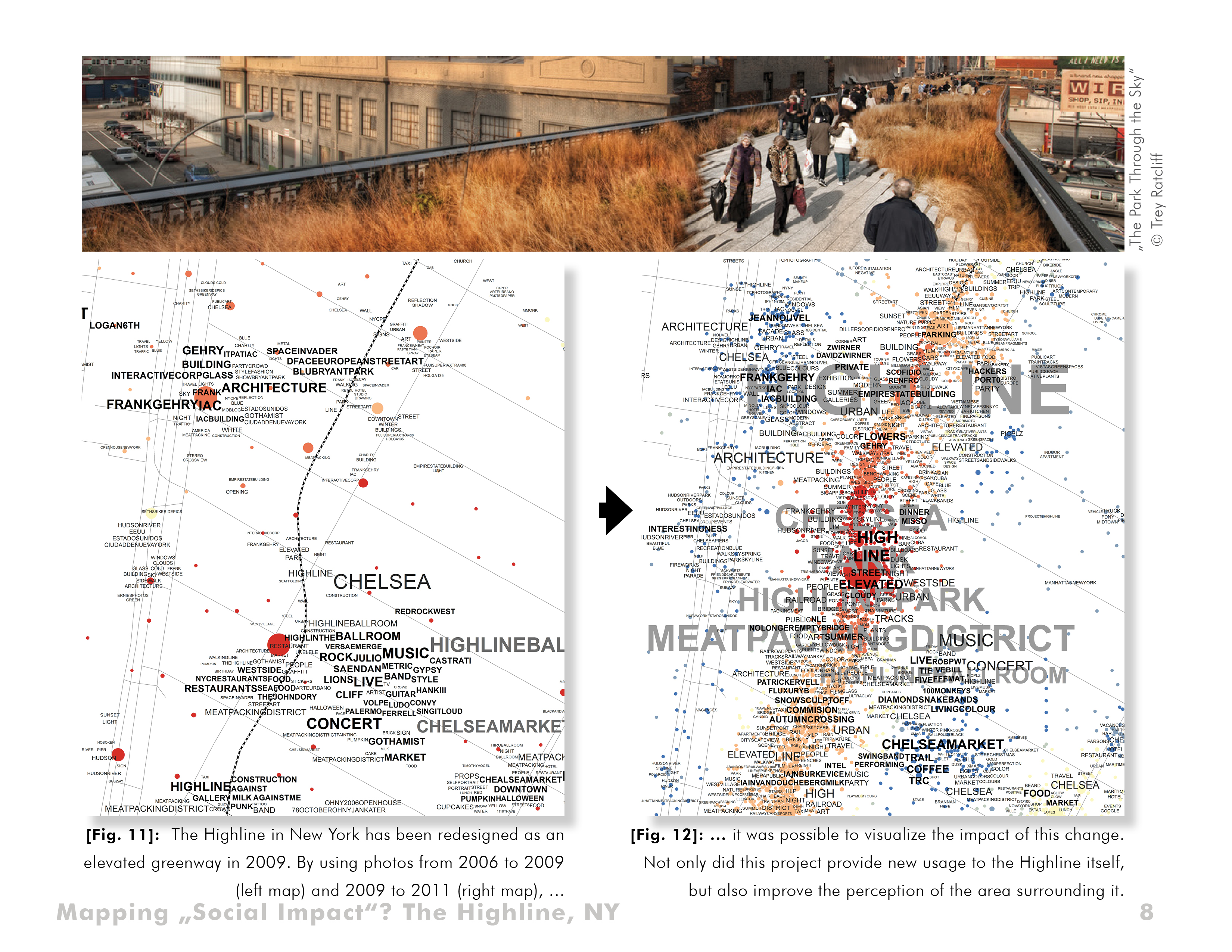
Mapping "Social Impact?" The Highline, NY
Download Hi-Res ImageImage: Alexander Dunkel
Image 8 of 15
 Close Me!
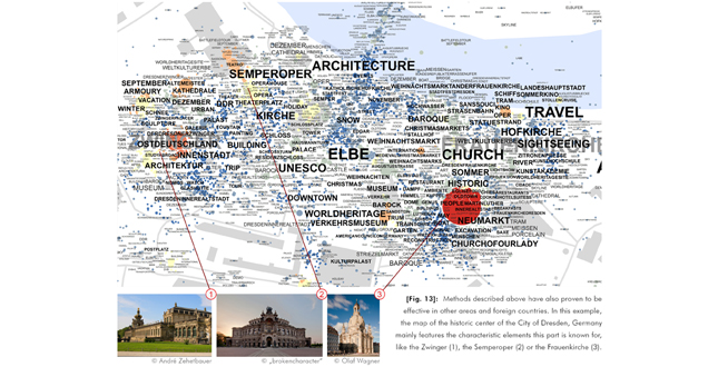
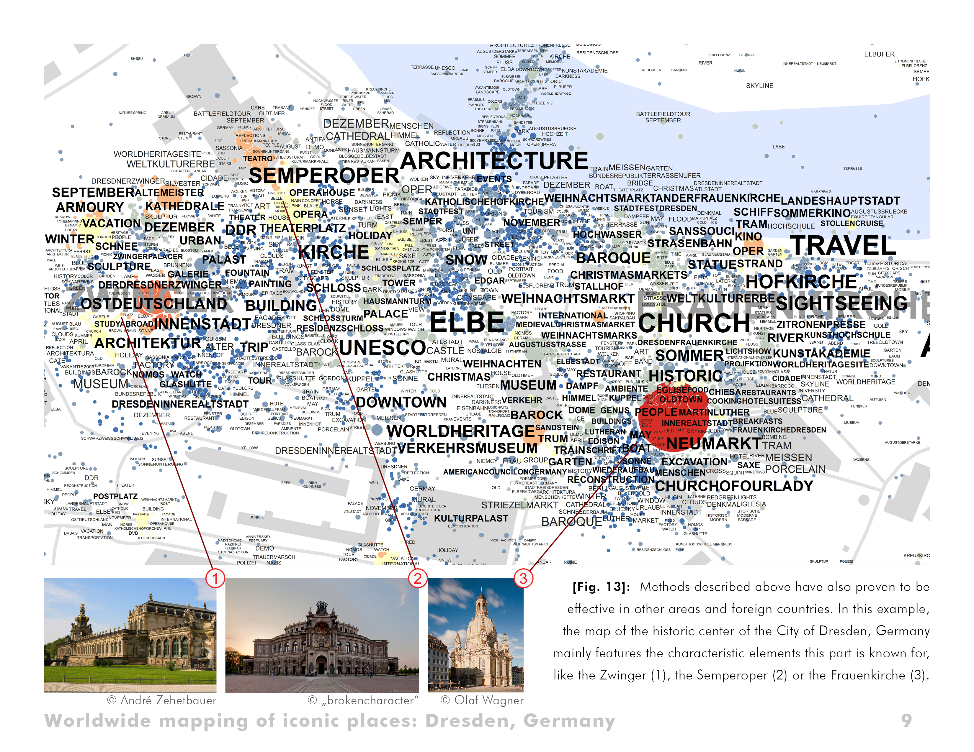
Worldwide mapping of iconic places: Dresden, Germany.
Download Hi-Res ImageImage: Alexander Dunkel
Image 9 of 15
 Close Me!
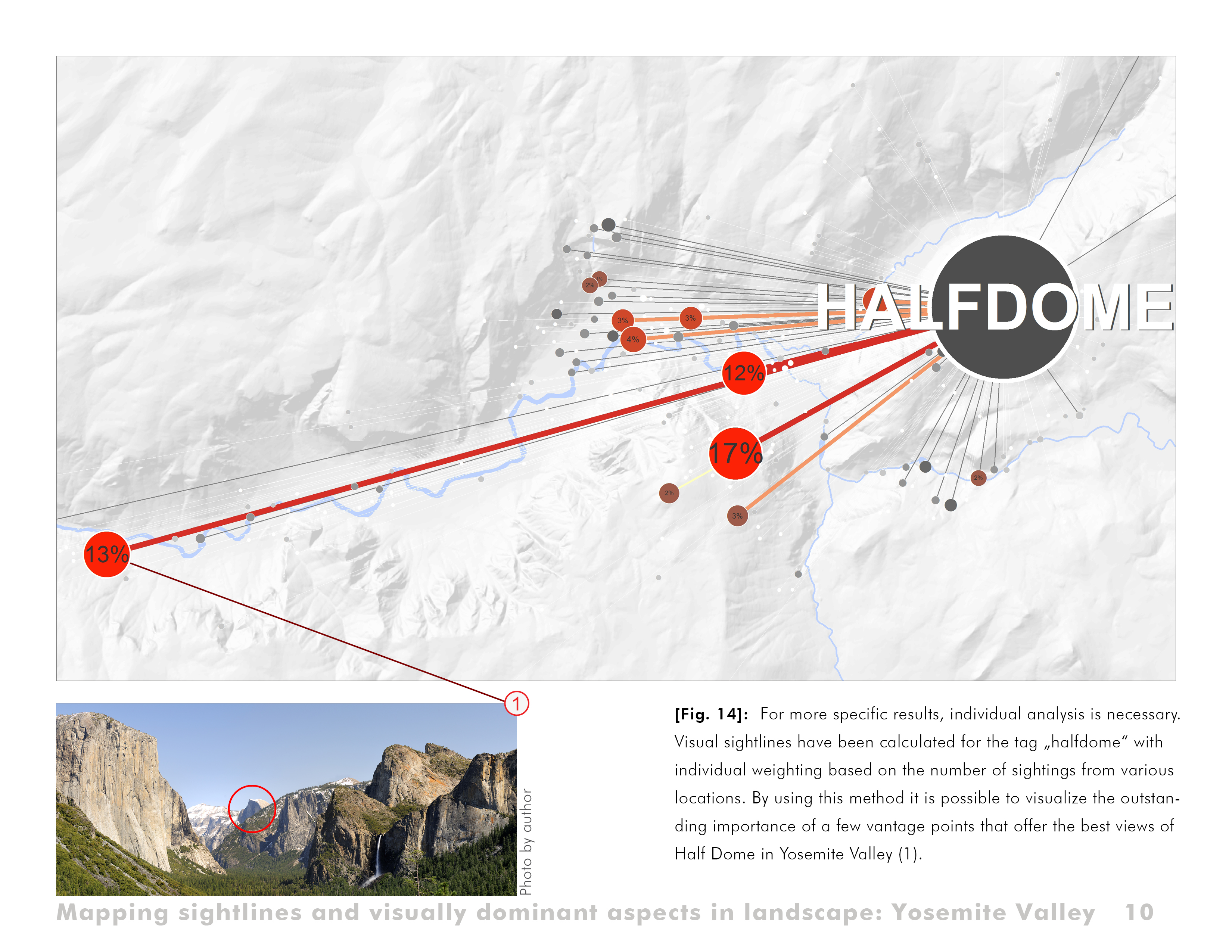
Mapping sightlines and visually dominant aspects in landscape: Yosemite Valley.
Download Hi-Res ImageImage: Alexander Dunkel
Image 10 of 15
 Close Me!
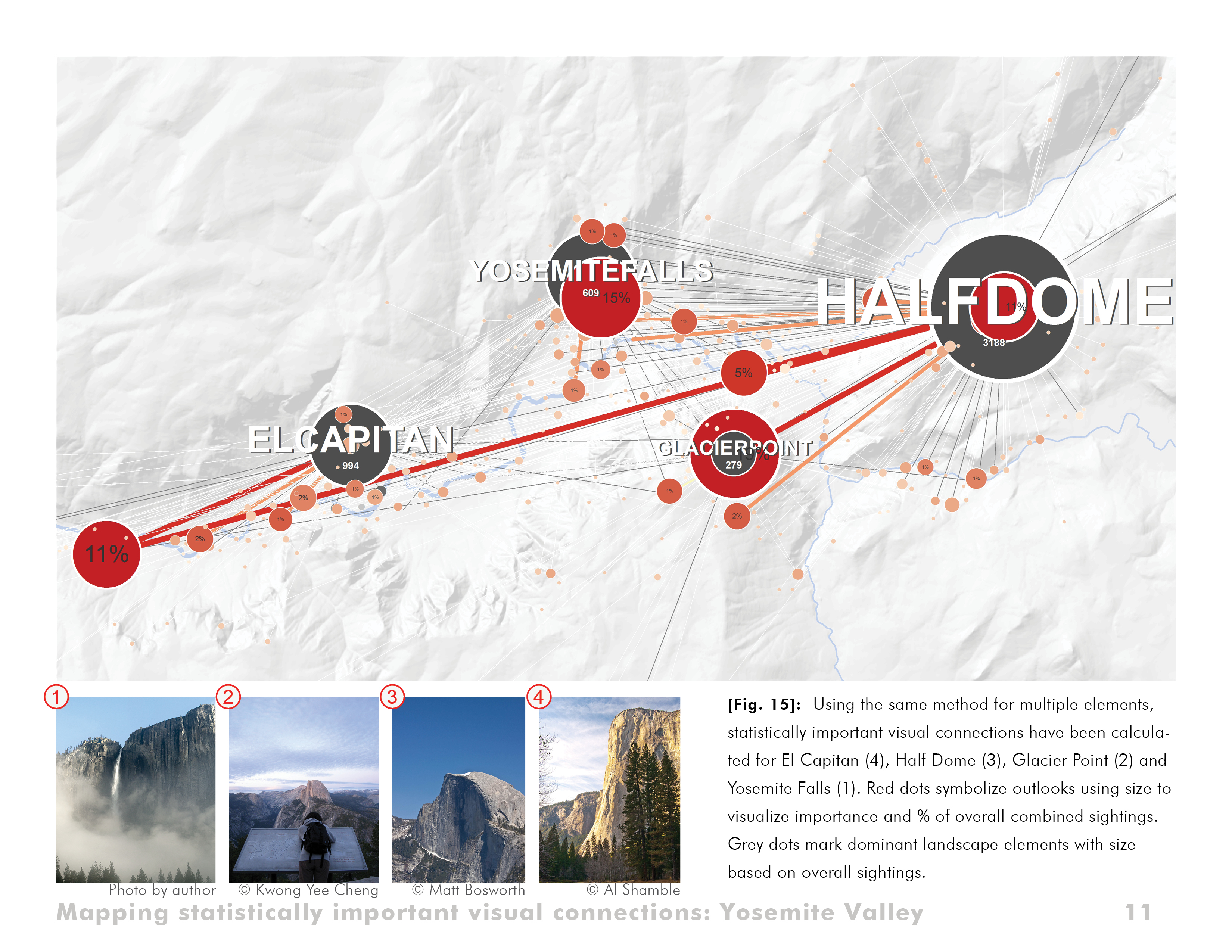
Mapping statistically important visual connections: Yosemite Valley.
Download Hi-Res ImageImage: Alexander Dunkel
Image 11 of 15
 Close Me!
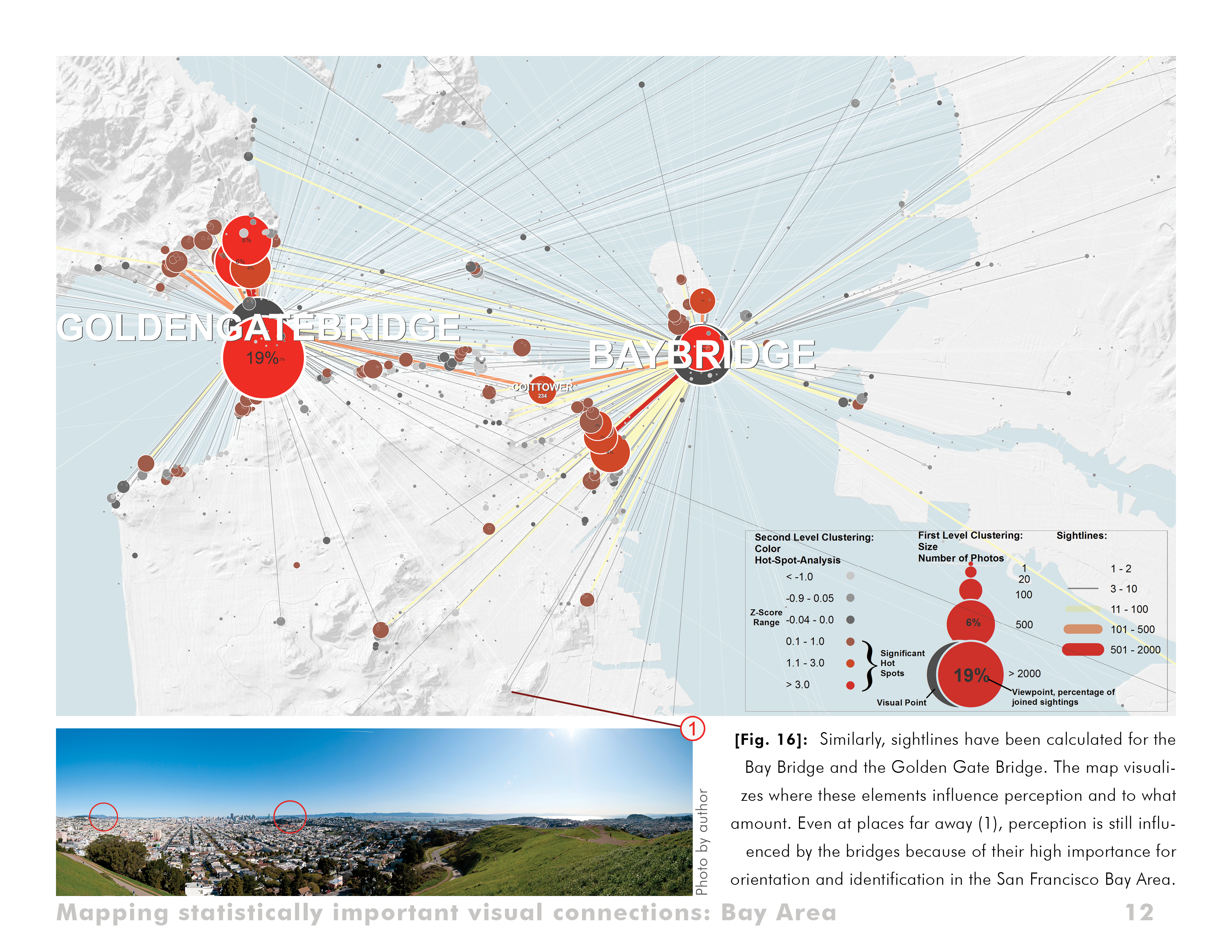
Mapping statistically important visual connections: Bay Area.
Download Hi-Res ImageImage: Alexander Dunkel
Image 12 of 15
 Close Me!
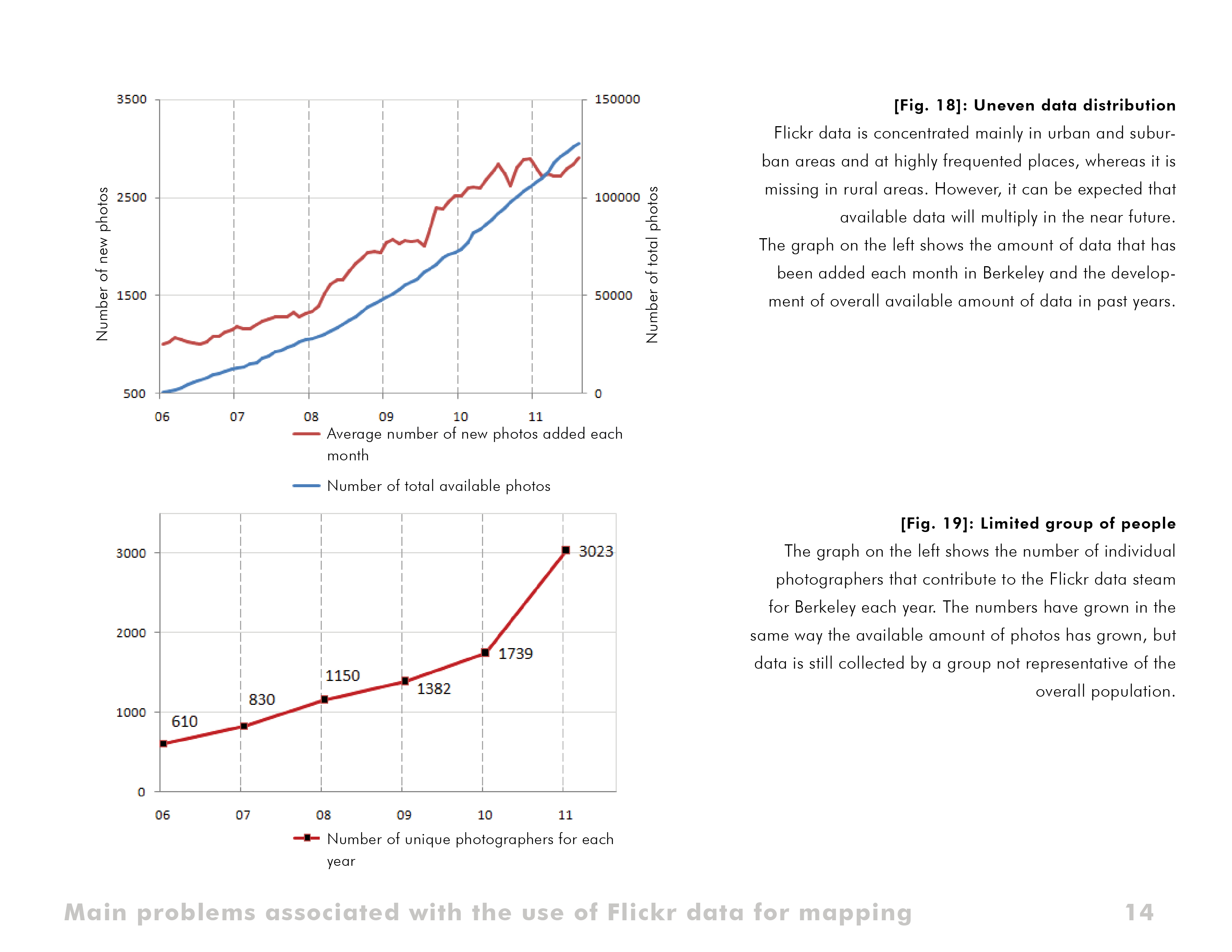
Main problems associated with the use of Flickr data for mapping.
Download Hi-Res ImageImage: Alexander Dunkel
Image 14 of 15
Project Statement
Compared to traditional data sources such as government data, crowd-sourced data provides information on identification, perception/emotion and social interaction that is currently unavailable. However, fundamentally new approaches are required to map, visualize and analyze crowd-sourced data's undiscovered patterns as well as to explore implications for professions working with people and the real environment. The goal of this research is to identify potential applications and to develop methods for putting this knowledge into use in Landscape Architecture and Environmental Planning.
Project Narrative
This doctoral thesis has evolved from my past work as a Landscape Architect and first took shape during my time as a Regional Planner in Germany, where I dealt with the development of landscape on a regional and state scale and large amounts of data, but also at the interface between multiple professions.
The term “Network-Landscapes” derives from the connection between the physically existent space and the virtual internet and illustrates the special focus of this thesis at the interface between these two systems. It is based on a trend that has taken place in recent years on the internet, with essential and so far untapped possibilities to find answers to important questions in the fields of Landscape Architecture and Environmental Planning. This trend is best described by the following quotation from the Dutch project “The Mobile City”:
"It is no longer useful or even possible to talk about the city as being only physical, or the digital world as purely ‘virtual’ (not real or not material). The physical city and the spaces of digital technologies merge into ‚hybrid space‘. These developments in formerly separated domains profoundly influence the ideas we have of time, space and place, citizenship and identity." — Martijn de Waal & Michiel de Lange, 2010, "The Mobile City"
The unique connection between the internet and reality has been one of the most significant shifts in everyday life in recent years. Currently, there are no methods for putting this knowledge to use in planning environments. Before this can happen, fundamental definitions need to be clarified on a interdisciplinary level, as far as questions of processing and finding data, and how to separate important from unimportant information.
For this reason, basic research has been conducted during a one-year stay abroad in San Francisco. It is one of the hot spots worldwide in regards to amount and availability of crowd-sourced data, but it is also one of the few places where related knowledge already exists. The results of this first, explorative phase are summarized in this submission. A large number of potential applications could be revealed for multiple fields of work, including but not limited to professions such as Architecture, Urban Planning or Geographical and Social Sciences. The second part of this doctoral thesis will be conducted in Germany, focusing on specific questions related to Landscape Architecture and Environmental Planning.
Theoretical Background
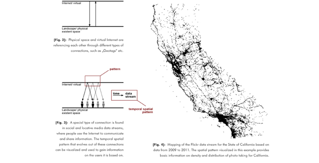
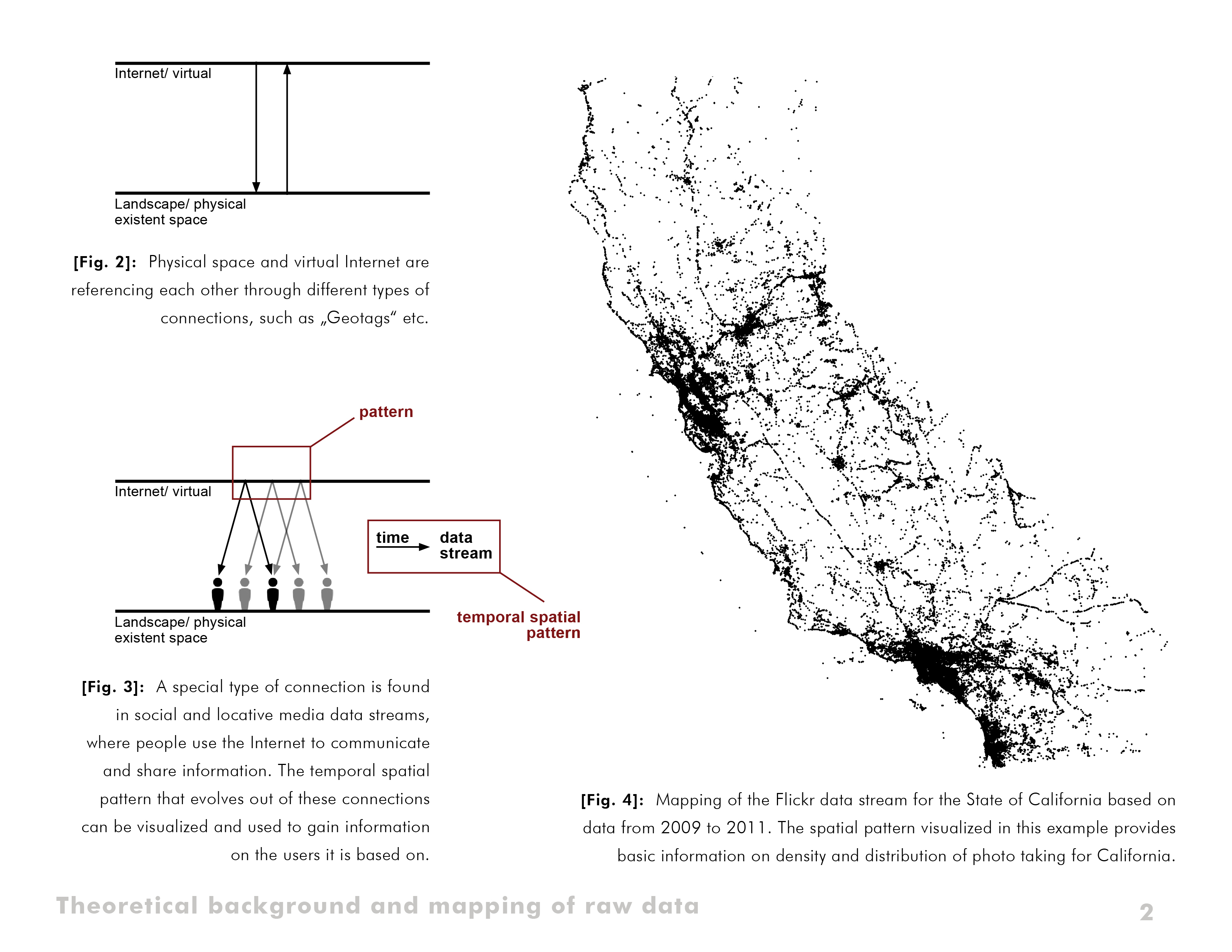
An objective of this thesis has been the development of implementation-oriented models that deal with the complex connections between physical space and the virtual world of the Internet. Figures 2 and 3 illustrate these connections.
Of particular interest are data streams evolving from social and locative media. In contrast to other spatial data that is available in the internet, these connections are based on people's use of the Internet for purposes of communication and information sharing. While so far the term "data stream" has mainly been used in information and computer sciences, it is well-suited for describing and pre-selecting relevant data for this research. By definition, a data stream is a continuous and ongoing flow of information with an unknown amount of data and an unknown number of participants. The assumption to be proven was, if a large number of people communicate and share information, analyzing the underlying temporal spatial pattern may provide information on the users themselves and their connections to the real environment.
Methodology
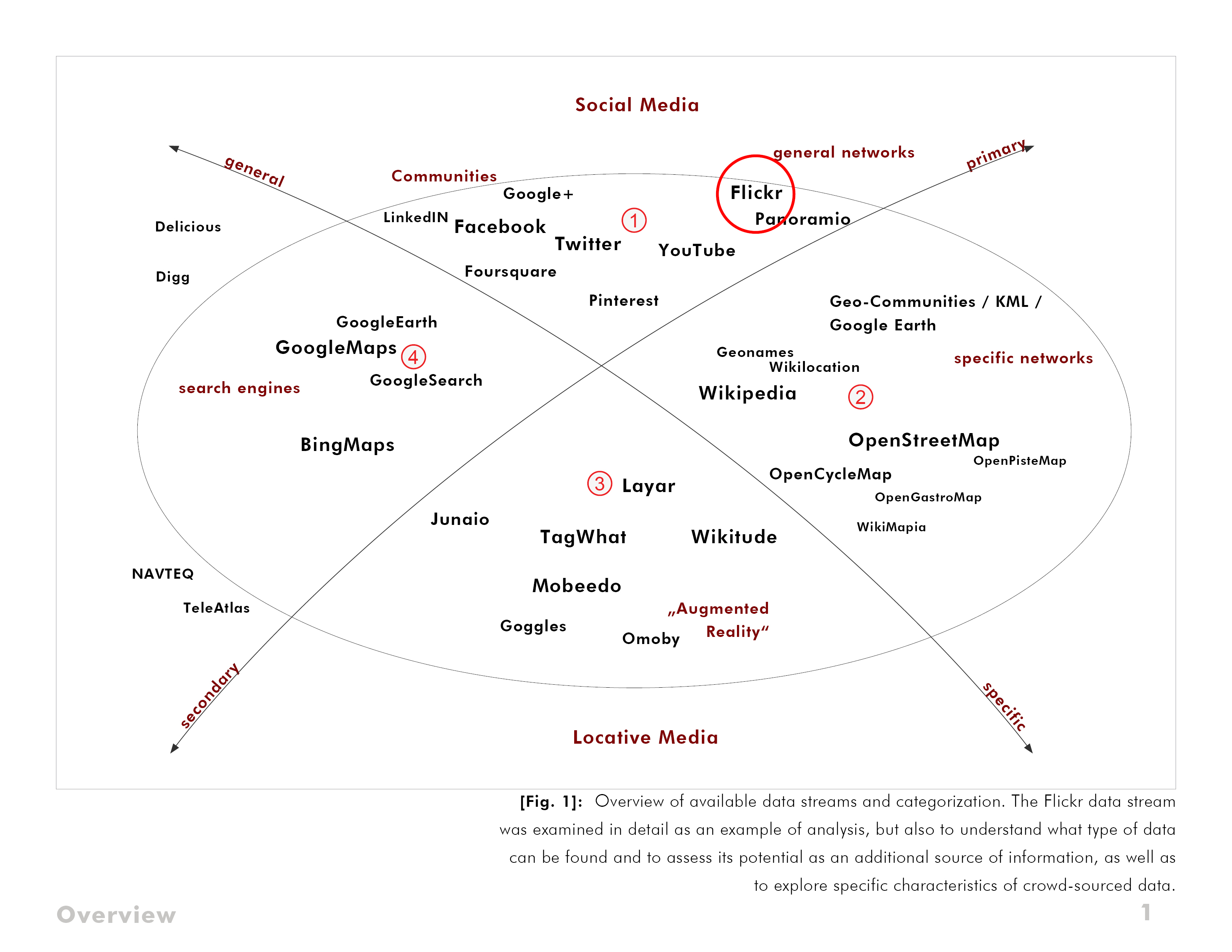
Available data streams have been collected, characterized and categorized and a single data stream has been examined in detail as an example of analysis, but also to understand what type of data can be found and to assess its potential as an additional source of information, as well as to explore specific characteristics of crowd-sourced data.
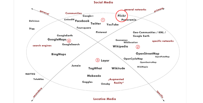
Data streams can be sorted into 4 groups: primary general data streams, primary specific data streams, secondary general data streams and secondary specific data streams (Figure 1). The first group of primary general data streams is where data is being created in the first place and includes more than 200 data streams. About 20 of these were of primary relevance for this research. One of these, the data stream of the photo sharing community Flickr was selected for detailed investigation. Among other reasons, Flickr has already been used in other research areas and with its current volume of 53 Mio Users, 7 Billion overall photos and over 3000 new photos being added every minute, a necessary minimum amount of available data was guaranteed.
The objective was to visualize patterns of interest and summarize the process of analysis as an example. In addition, this analysis also helped to understand the way crowd-sourcing works and to explore areas of future application. The methods used to analyze the data already exist in related disciplines like informatics, geo- and social sciences, but have been applied in a new way to visualize aspects relevant to Landscape Architecture.
Relationships Investigated and Methods of Inquiry Used
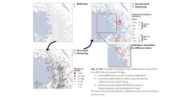
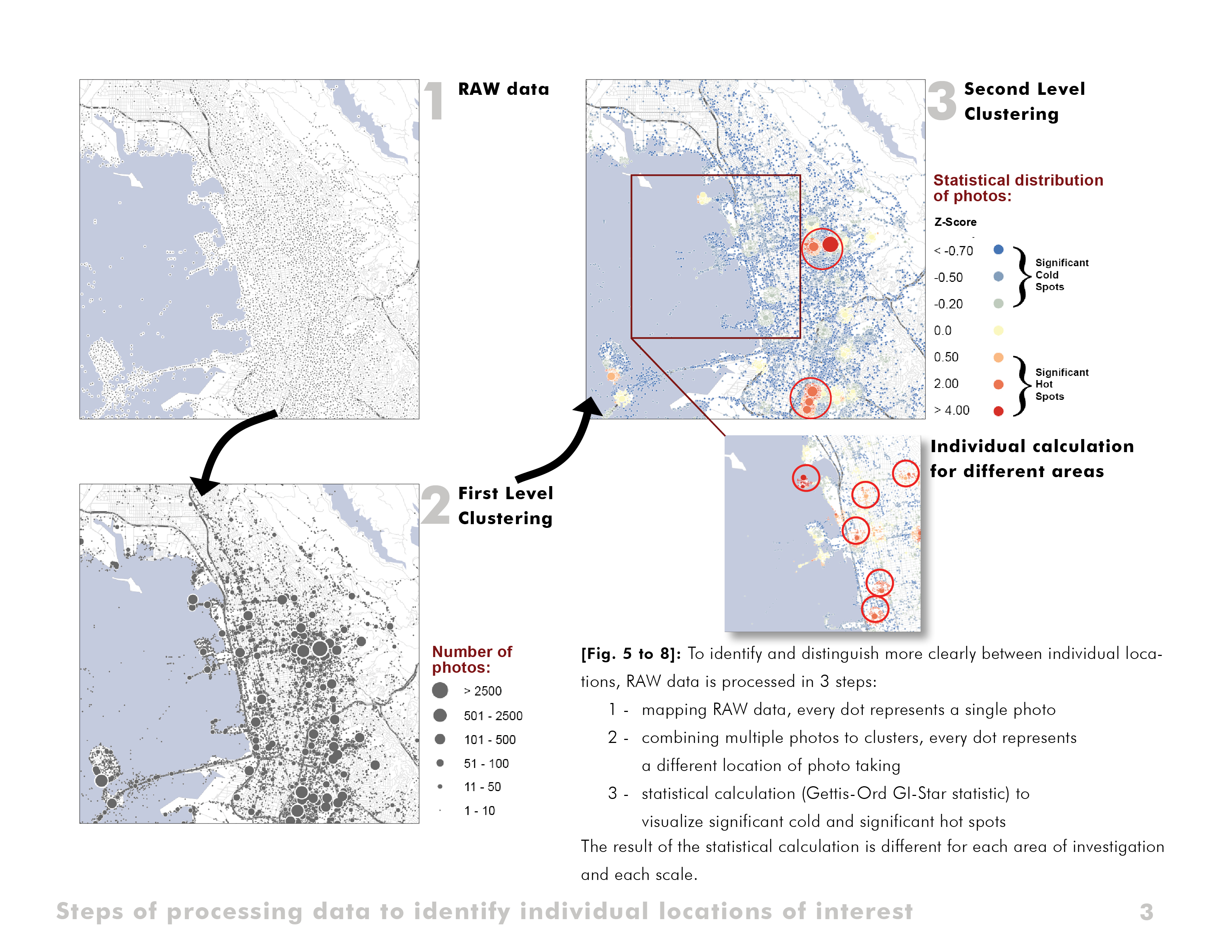
The unique characteristics of crowd-source data made it necessary to explore new ways of visualizing patterns. The first goal of this analysis was to evaluate the spatial distribution of available data and identify individual photo locations of interest. Without any processing only limited interpretation of the spatial distribution is possible (Figure 4). Therefore, a multi-step process has been used to create maps that first seem unusual, but provide a good overview and work well as a new way of information gathering (Figures 5 through 8).
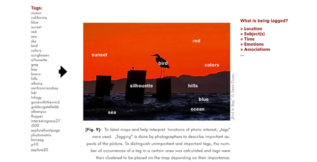
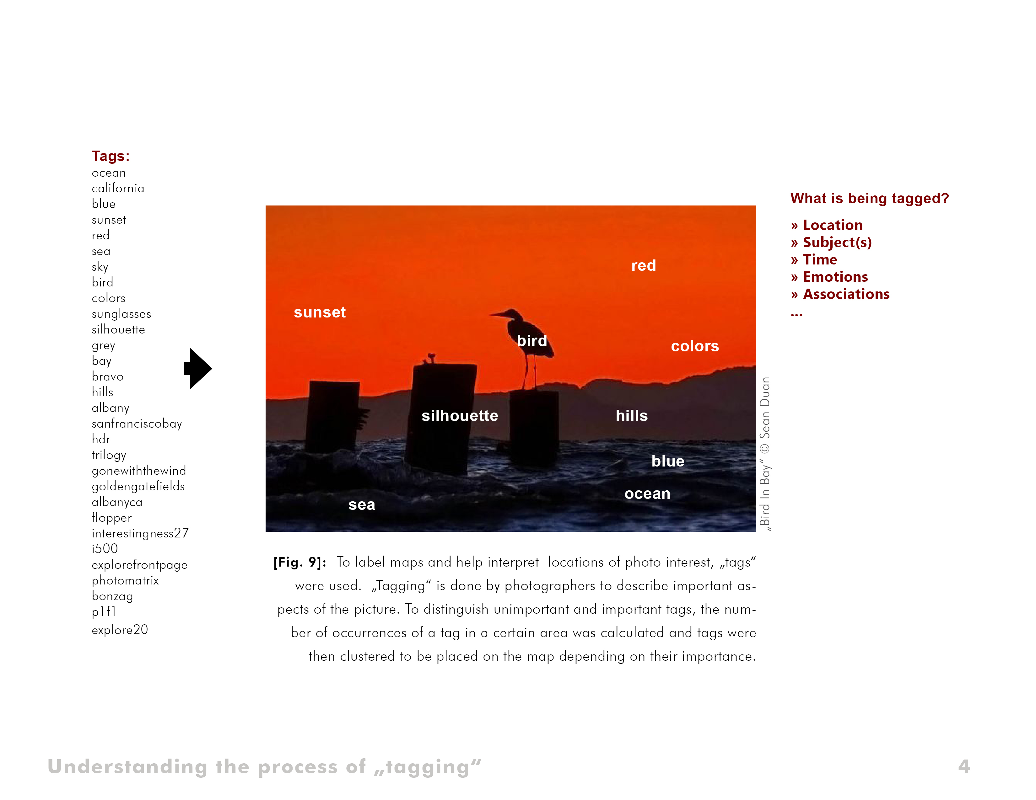
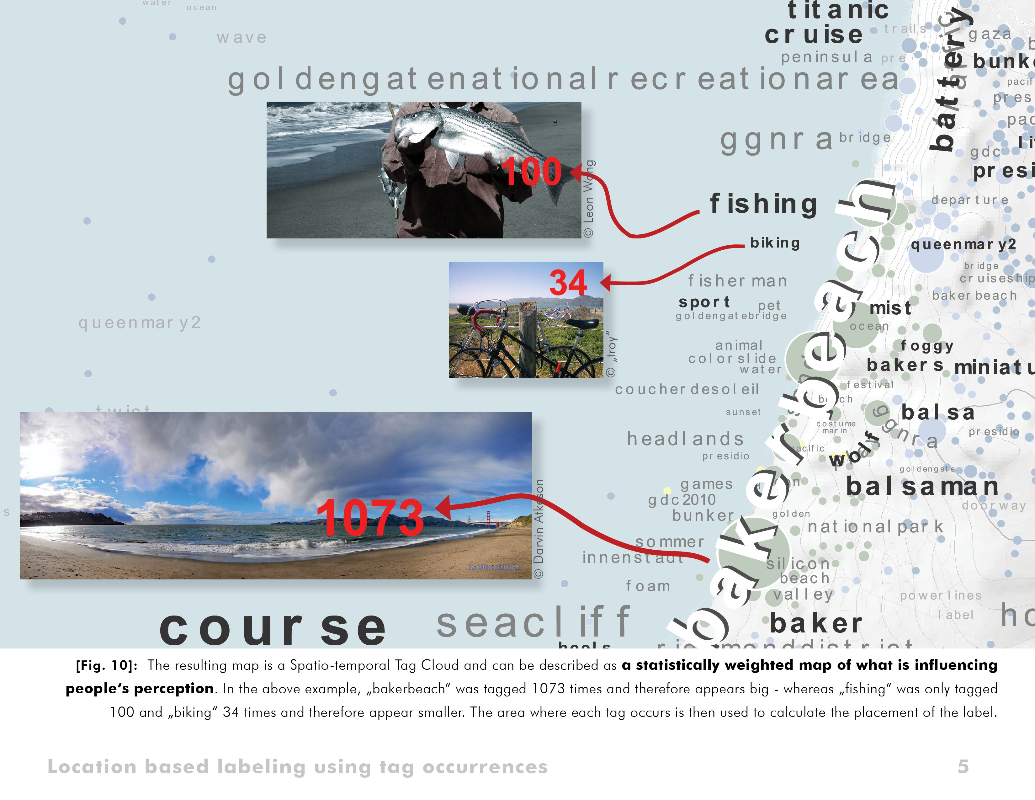
The resulting maps are spatiotemporal tag clouds and can be best described as statistically weighted maps of what is influencing people’s perception in certain areas. One of the characteristics of these maps is that labels may occur in different places compared to where the actual "object" is located (i.e. Golden Gate Bridge, while it exists only once, influences people's perception in a number of different locations throughout the Bay Area). As a supplement to other sources of information, this data may be helpful in many planning processes in which it is important to focus on the identification of people with their environment and the uniqueness (or missing uniqueness) of each part of the rural or urban landscape.
Maps have been created for various scales, ranging from local to state scale as well as for different rural and urban areas in California and the USA, but also for foreign countries such as Germany. While the graphics of all maps are similar, they feature unique characteristics bound to the examined location. Several of the patterns found are shown and interpret in Figures 10 through 13.
Evaluation and Results
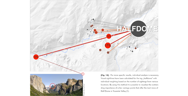
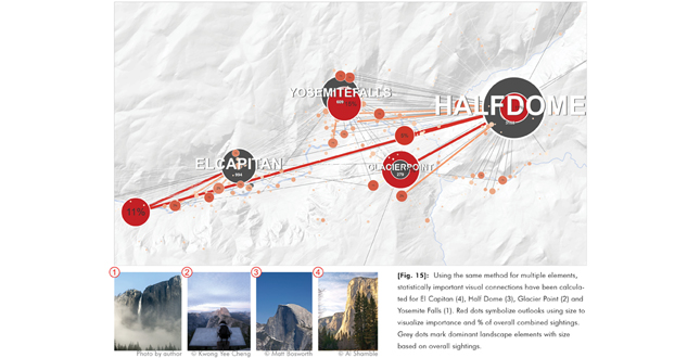
For the purposes of evaluation, additional methods have been developed to answer specific questions. It was possible to determine statistically important visual connections in Yosemite Valley and visualize the outstanding importance of a few vantage points that offer the best views of Half Dome (Figures 14 and 15).
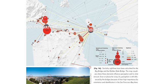
Similarly, sightlines have been calculated for the Golden Gate Bridge and the Bay Bridge, visualizing locations where the perception is influenced by the two important landmarks and to what amount (Figure 16). The resulting maps in this case are of special interest, because they show more accurate results than traditional viewshed analysis, which is based on digital elevation models and currently used in regional planning to, for example, define and protect important sightlines to historic buildings.
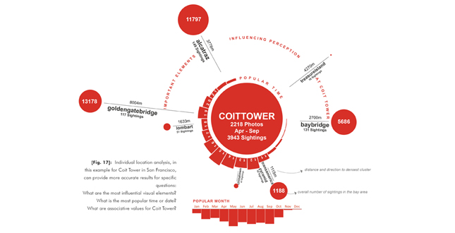
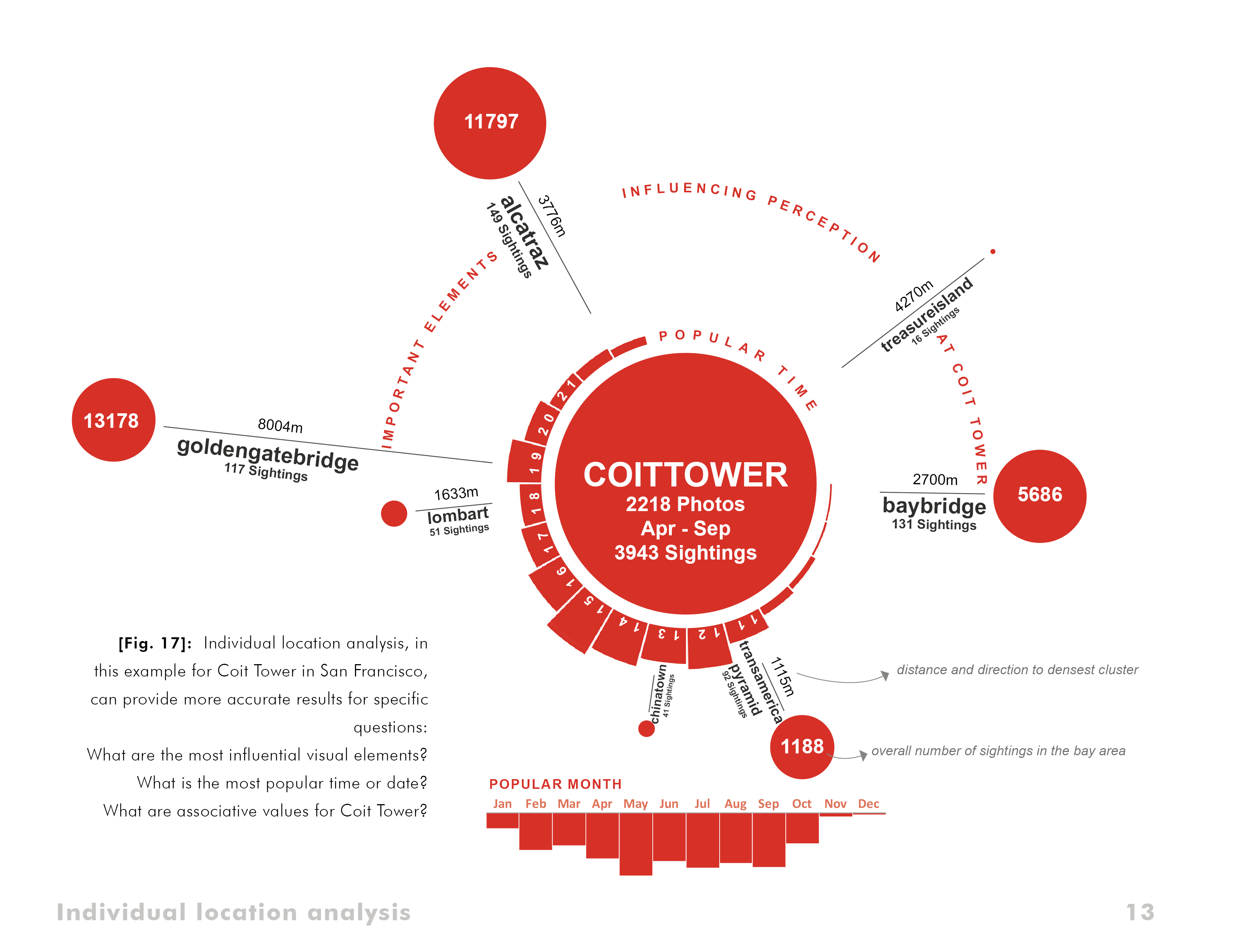
Also, this research has shown that results are more accurate the more specific questions were asked. Individual location analysis for example can provide additional information on the complex connection between space, identity and personal perception (Figure 17). In the field of landscape architecture, this data may help better understand the unique characteristics of a certain place.
Discussion of Potential Issues
Discussion of issues using this data in real planning environments is an integral part of this research. Multiple questions have been looked at in detail, but it is necessary to continue and develop solutions during ongoing research.
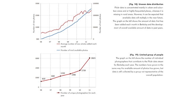
One of the most significant questions is related to the limited group of people this analysis has been based on. In the example of Flickr, maps are based on a limited group of photographers and are therefore not representative (Figure 19). Even the use of multiple data streams and careful, goal-oriented interpretation may result in wrong decisions. Related research indicates that analysis itself can reveal information on the group of participants but questions of privacy, data protection and availability prevent direct application of results so far.
With its exponential growth, accessing and processing this type of data is another issue that becomes increasingly more relevant (Figure 18). It is an important goal to enable professionals but also participants without extensive technical knowledge and data processing background to use methods and work with this kind of data.
Conclusions Concerning the Significance of the Results and Further Need for Research
The advantages of crowd-sourced data, in comparison to traditional data sources such as government data, are found mainly in areas where data is currently completely missing or where communication, feedback and highly up-to-date data are integral parts of projects.
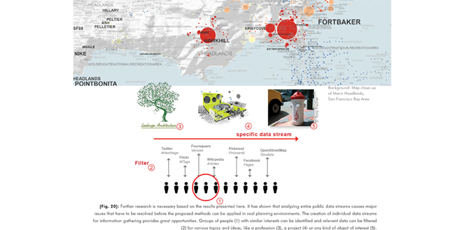
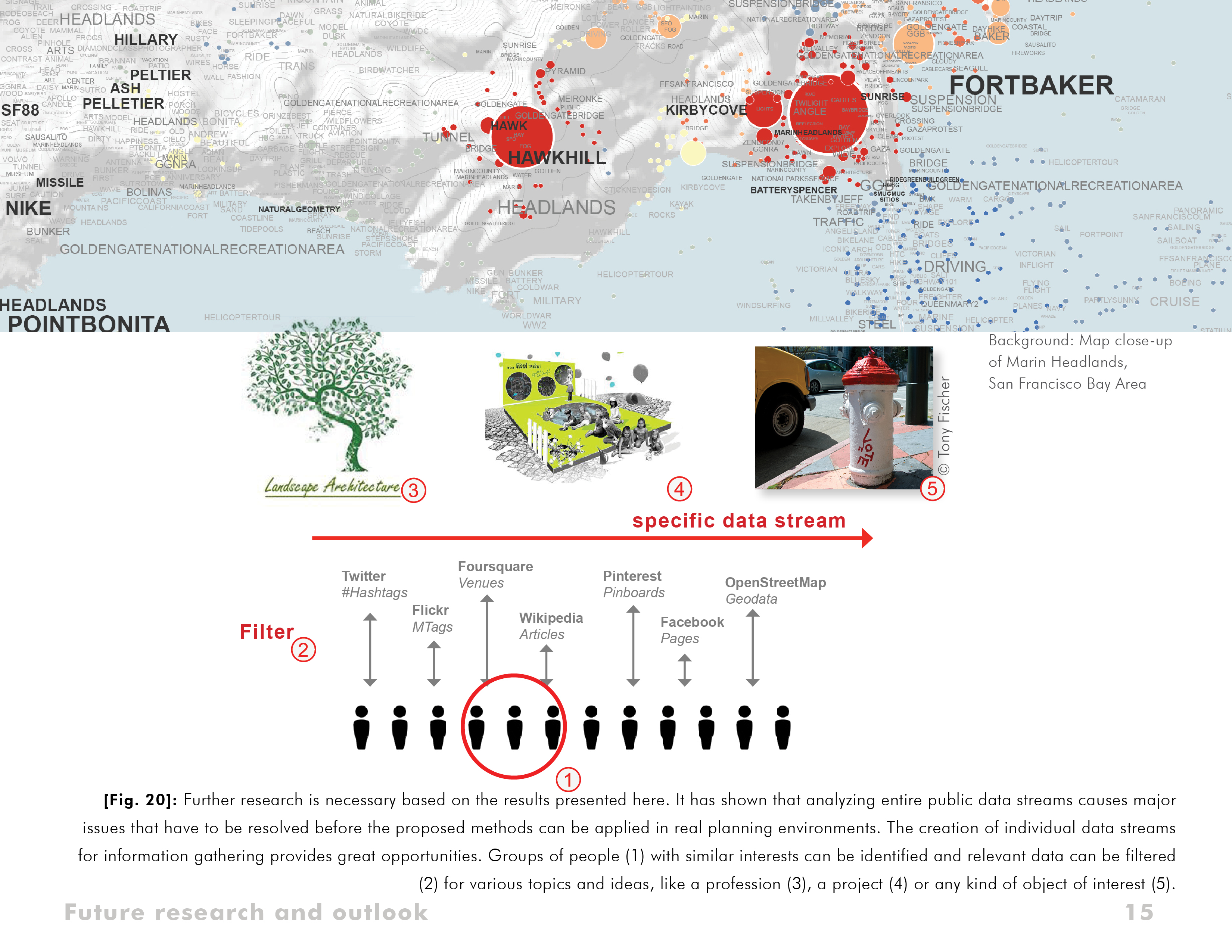
Based on the results of the explorative phase, success is not seen in analyzing entire, public data streams but custom-creating individual data streams for specific applications using existing methods already used in social and locative media. Figure 20 represents a potential future model of data exchange and a direction for ongoing research. Opportunities are seen for professionals such as designers, landscape architects or architects in the creation of individual, subject specific data streams that can be used to better address specific user needs, to build more focused solutions and to get feedback in a fast and efficient way.
At this point it is most important to raise awareness of necessary research on an interdisciplinary level, because of the very fast development of this type of data, but also its broad range of influences and its potential for enhancing work flows for various professionals dealing with the interface between people, design, planning and physical space.
Additional Project Credits
Faculty Advisors
Dr. Mona El Khafif, California College of the Arts, San Francisco; Prof. Dr. Catrin Schmidt, Dresden University of Technology, Germany; and Judith Stilgenbauer, University of California, Berkeley
Eric Fischer for pioneering work with the Flickr data stream and source of inspiration
Aaron Straup Cope for general support, motivation and philosophy talks.