


Honor Award
Dismantle/Rebuild: A New Framework for Willets Point
Melissa S. How, Student ASLA, Graduate, Harvard Graduate School of Design
Faculty Advisor: Miho Mazereeuw
 Close Me!
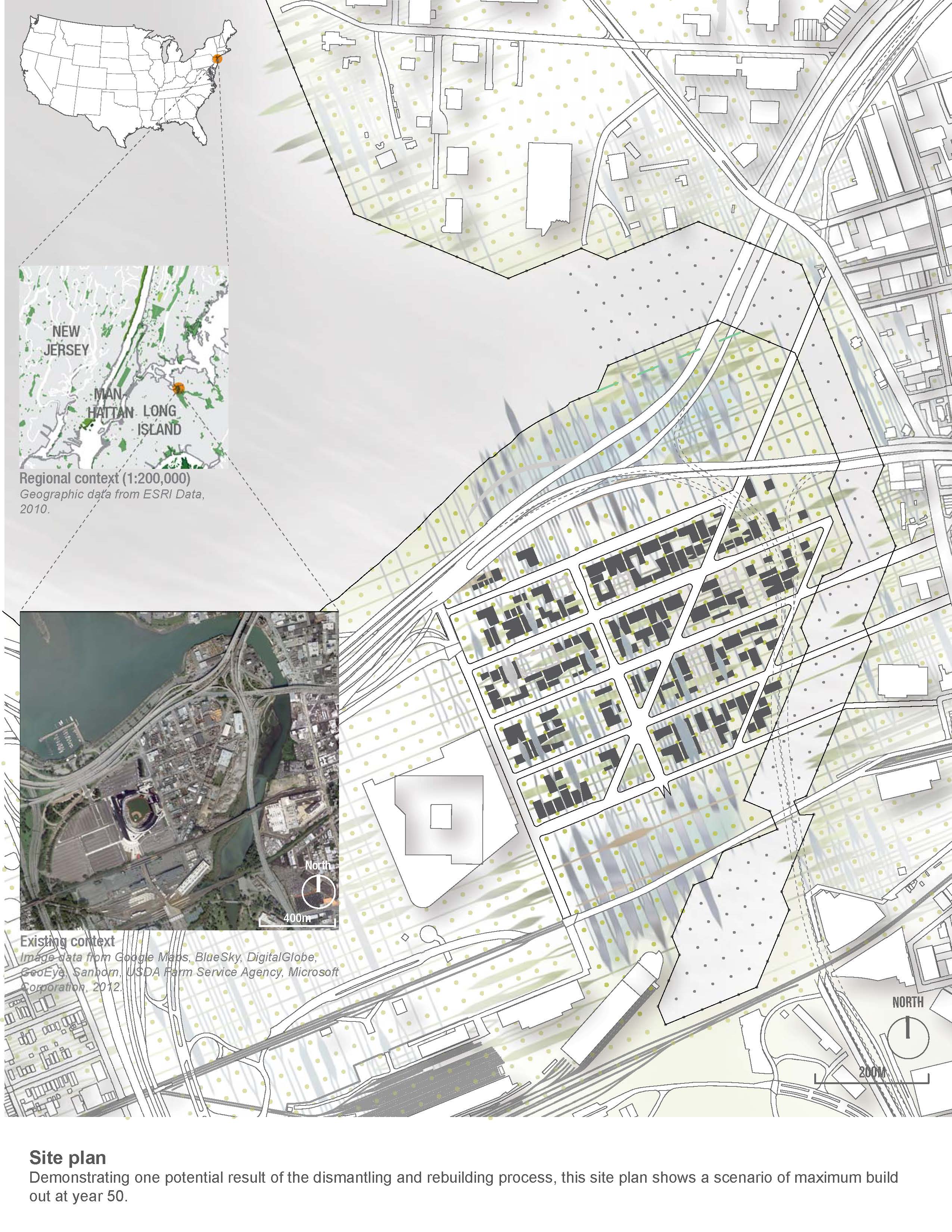
Site Plan. Demonstrating one potential result of the dismantling and rebuilding process, this site plan shows a scenario of maximum build out at year 50.
Download Hi-Res ImageImage: Melissa S. How
Image 1 of 15
 Close Me!
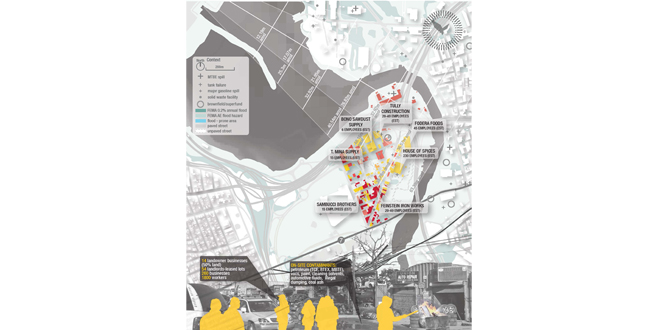
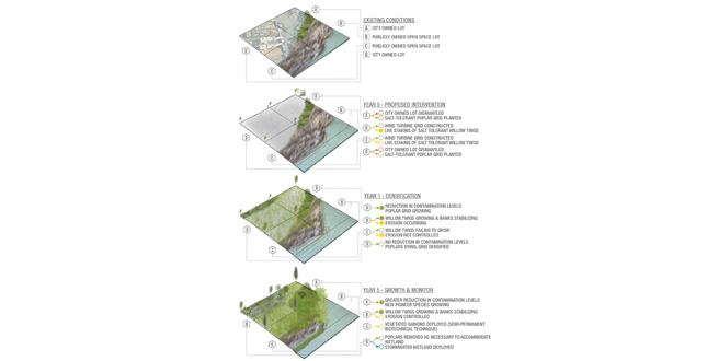
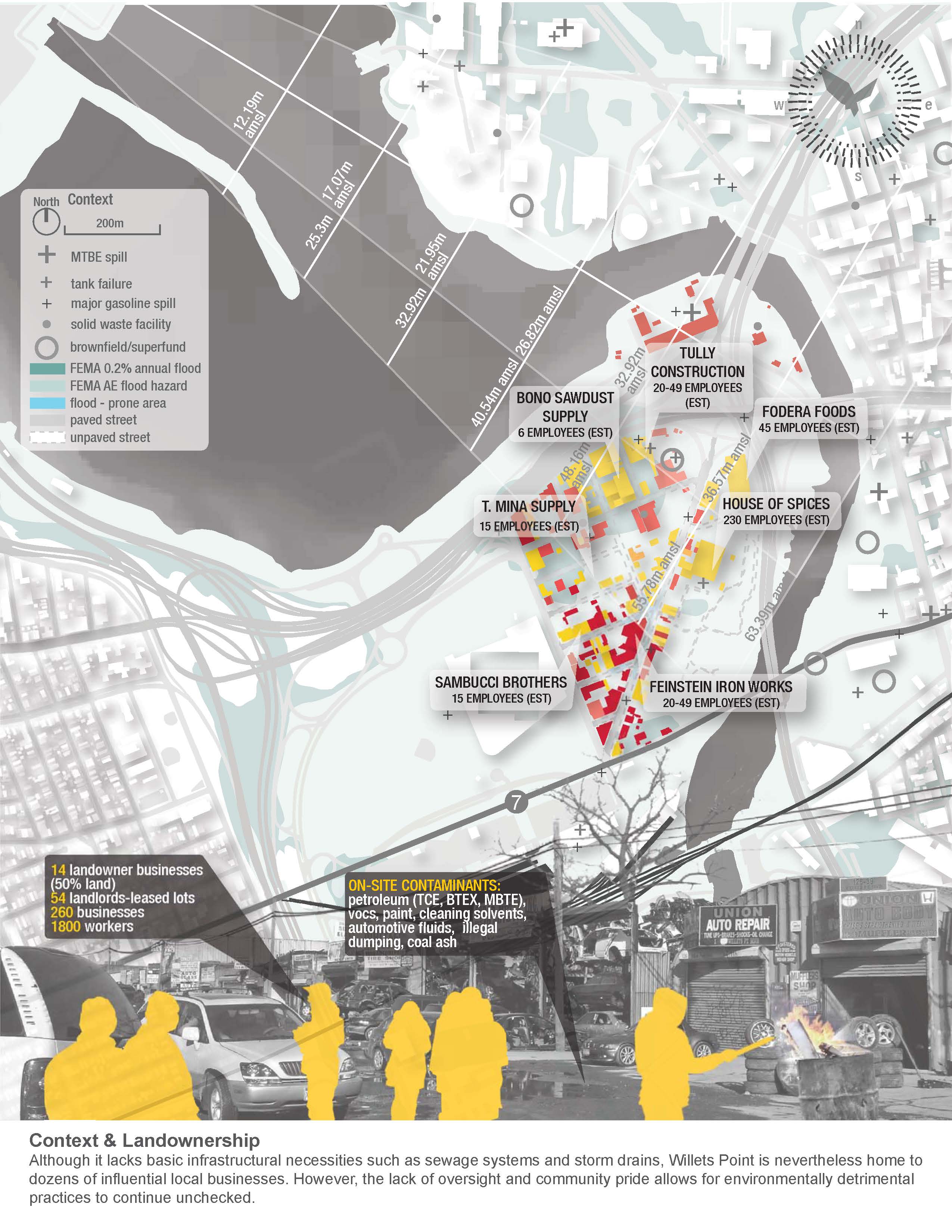
Context and Landownership. Although it lacks basic infrastructural necessities such as sewage systems and storm drains, Willets Point is nevertheless home to dozens of influential local businesses. However, the lack of oversight and community pride allows for environmentally detrimental practices to continue unchecked.
Download Hi-Res ImageImage: Melissa S. How
Image 2 of 15
 Close Me!
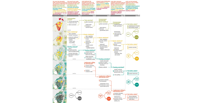
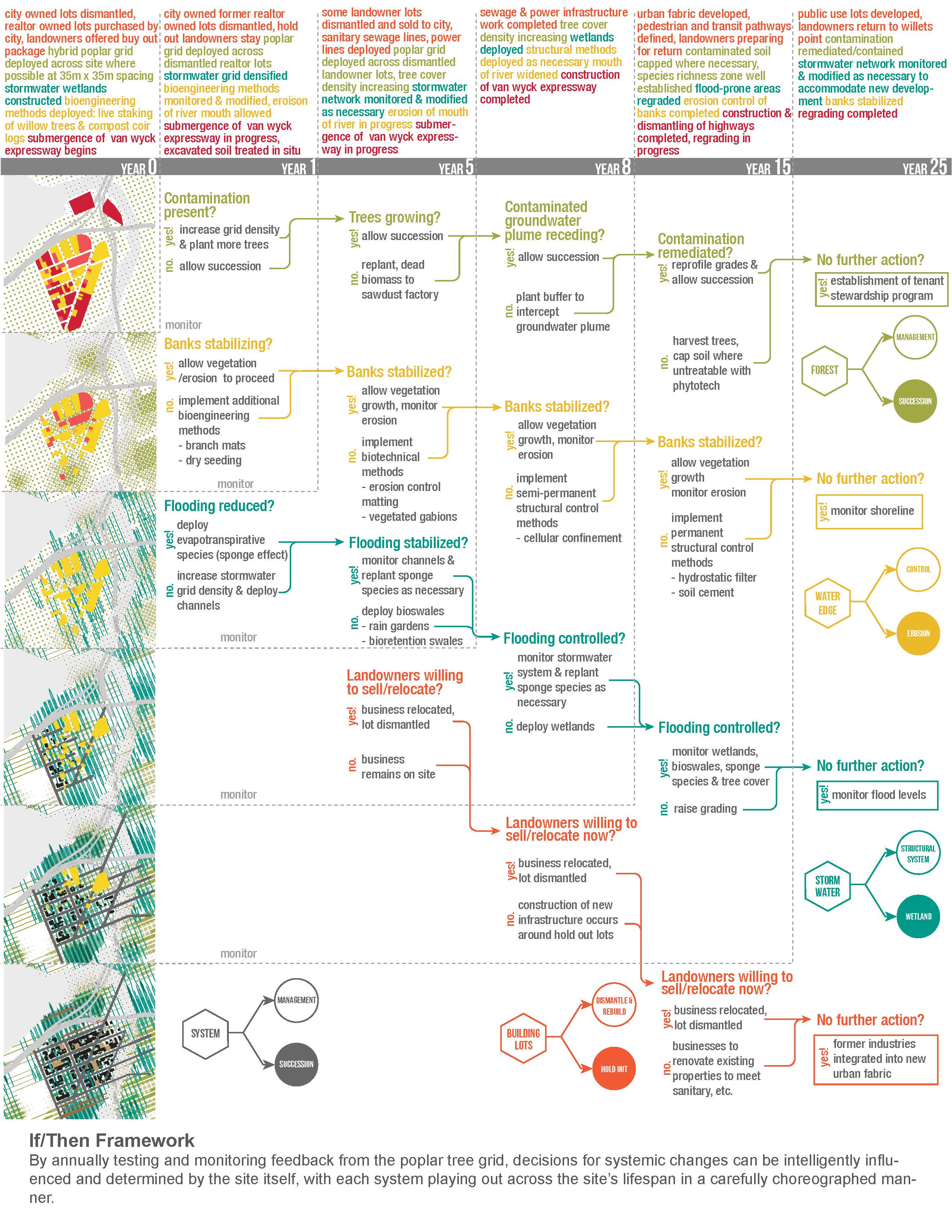
If / Then Framework. By annually testing and monitoring feedback from the poplar tree grid, decisions for systemic changes can be intelligently influenced and determined by the site itself, with each system playing out across the site's lifespan in a carefully choreographed manner.
Download Hi-Res ImageImage: Melissa S. How
Image 3 of 15
 Close Me!
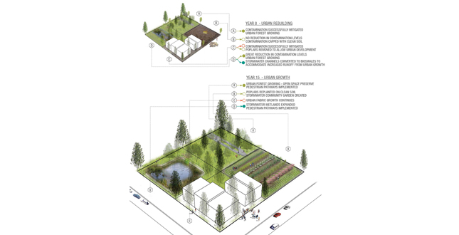
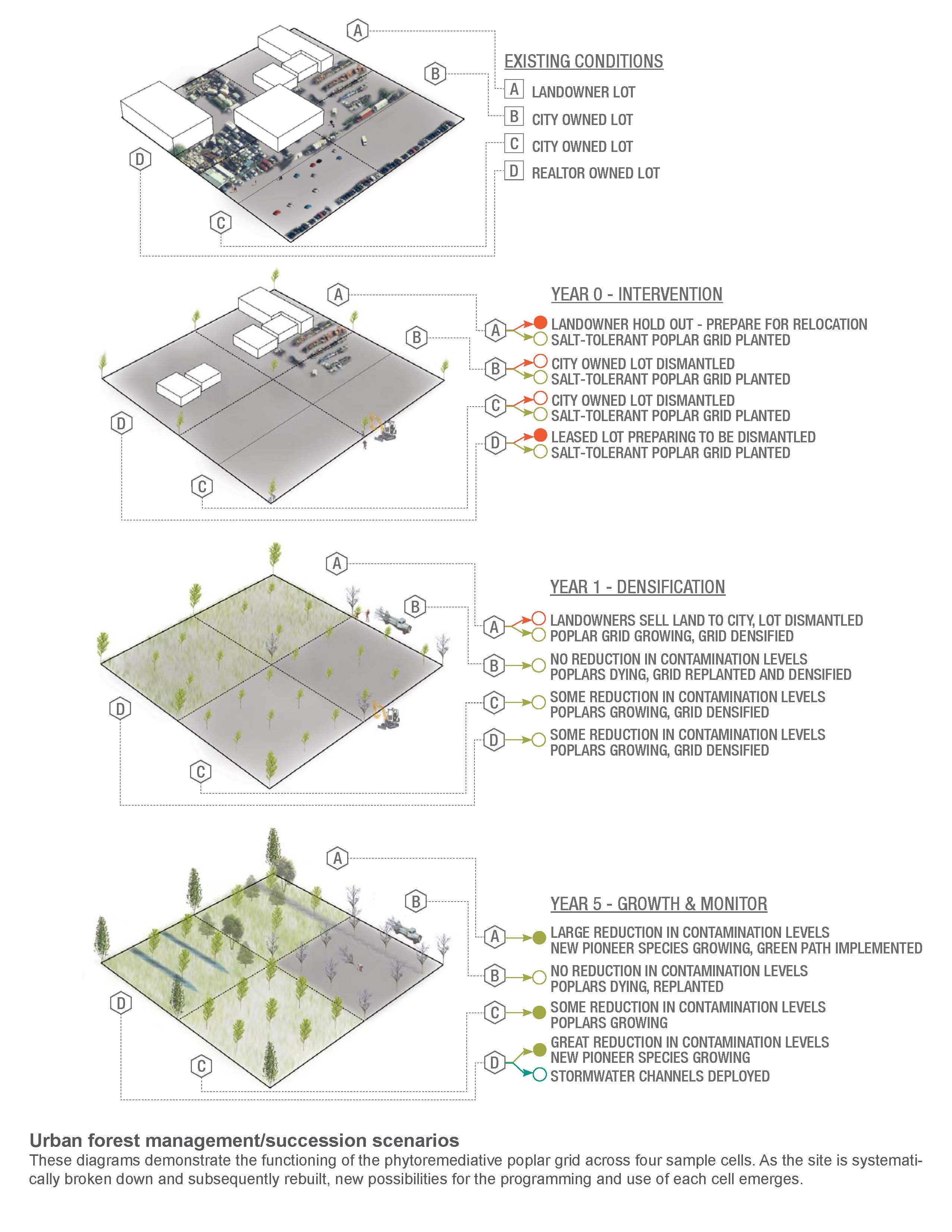
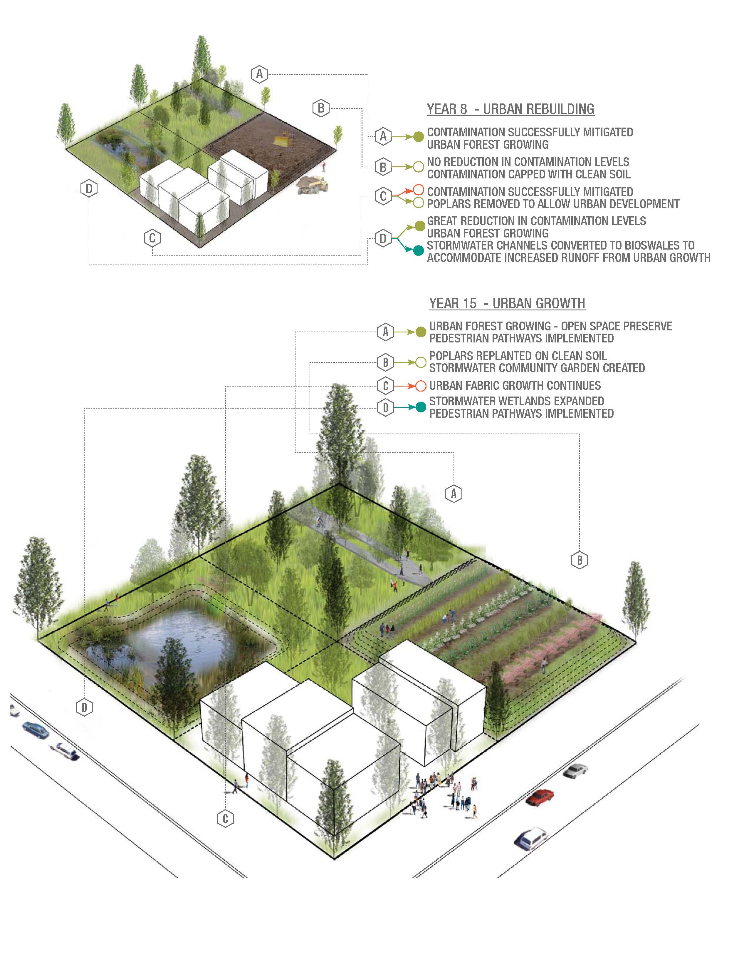
Urban Forest Management / Succession Scenarios. These diagrams demonstrate the functioning of the phytoremediative poplar grid across four sample cells. As the site is systematically broken down and subsequently rebuilt, new possibilities for the programming and use of each cell emerges.
Download Hi-Res ImageImage: Melissa S. How
Image 4 of 15
 Close Me!
Urban Forest Management / Succession Scenarios. These diagrams demonstrate the functioning of the phytoremediative poplar grid across four sample cells. As the site is systematically broken down and subsequently rebuilt, new possibilities for the programming and use of each cell emerges.
Download Hi-Res ImageImage: Melissa S. How
Image 5 of 15
 Close Me!
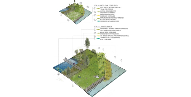
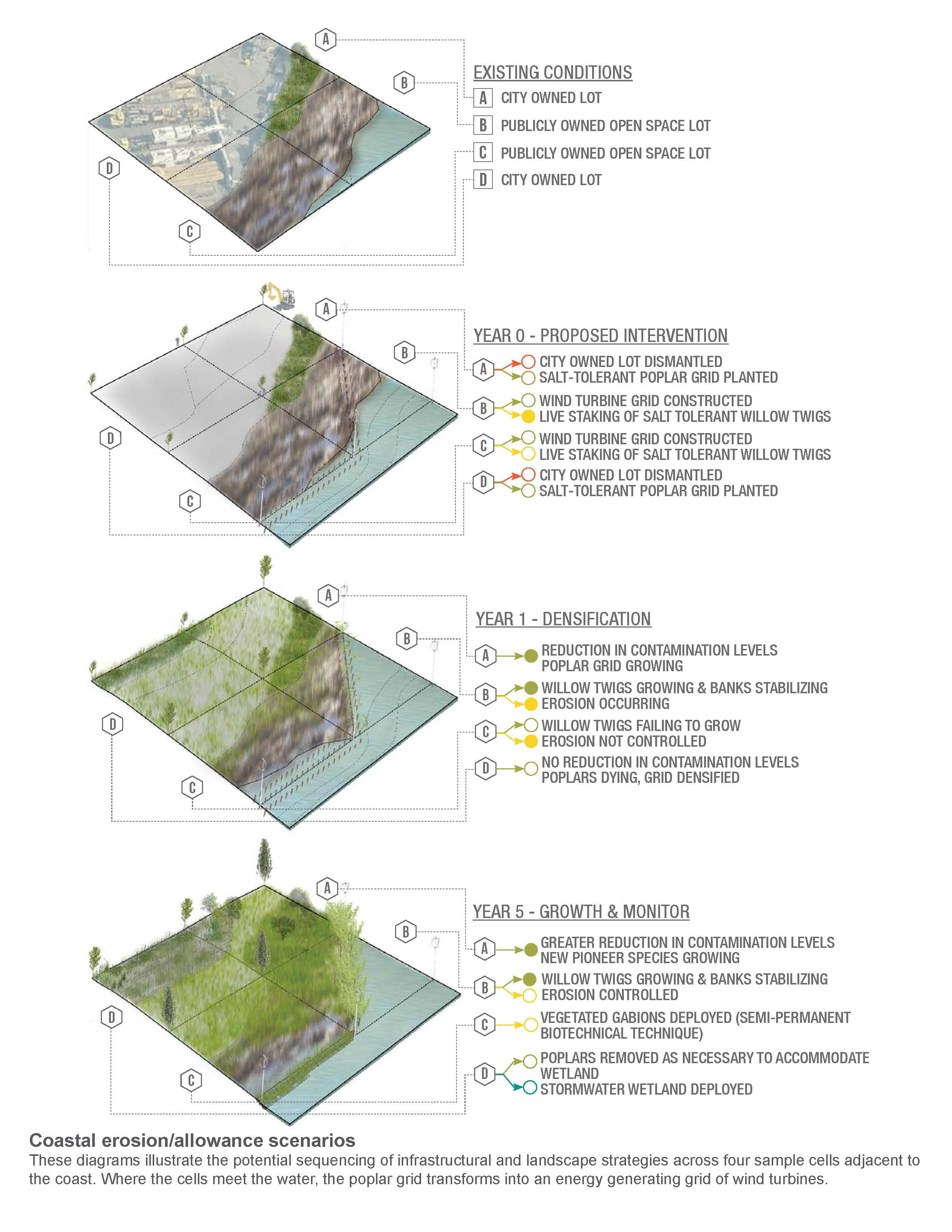
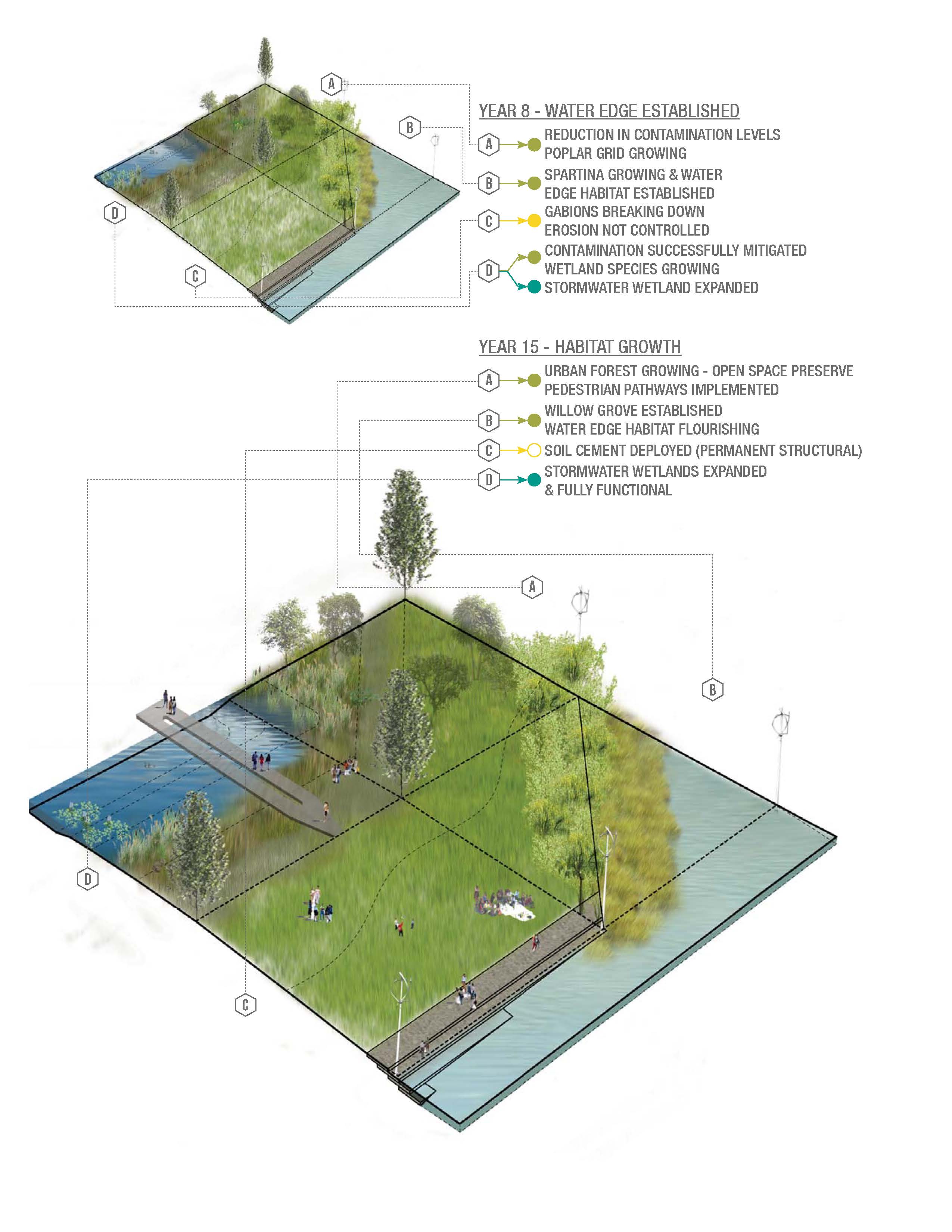
Coastal Erosion / Allowance Scenarios. These diagrams illustrate the potential sequencing of infrastructural and landscape strategies across four sample cells adjacent to the coast. Where the cells meet the water, the poplar grid transforms into an energy generating grid of wind turbines.
Download Hi-Res ImageImage: Melissa S. How
Image 6 of 15
 Close Me!
Coastal Erosion / Allowance Scenarios. These diagrams illustrate the potential sequencing of infrastructural and landscape strategies across four sample cells adjacent to the coast. Where the cells meet the water, the poplar grid transforms into an energy generating grid of wind turbines.
Download Hi-Res ImageImage: Melissa S. How
Image 7 of 15
 Close Me!
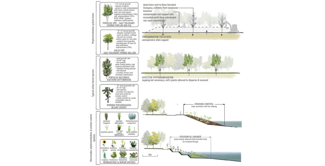
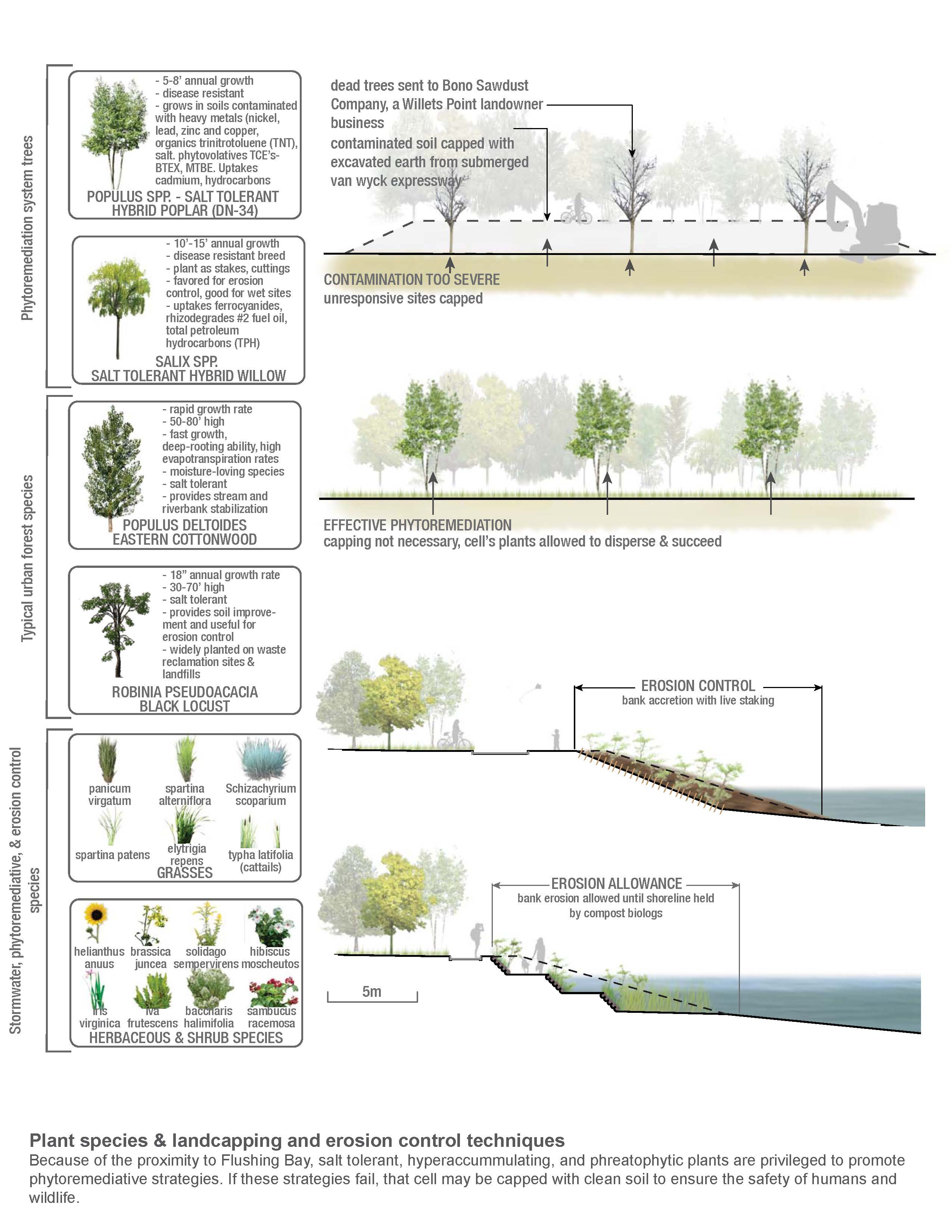
Plant Species and Landscaping and Erosion Control Techniques. Because of the proximity to Flushing Bay, salt tolerant, hyperaccummulating, and phreatophytic plants are privileged to promote phytoremediative strategies. If these strategies fail, that cell may be capped with clean soil to ensure the safety of humans and wildlife.
Download Hi-Res ImageImage: Melissa S. How
Image 8 of 15
 Close Me!
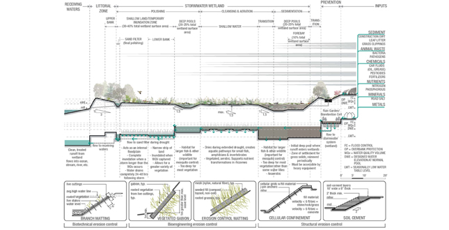
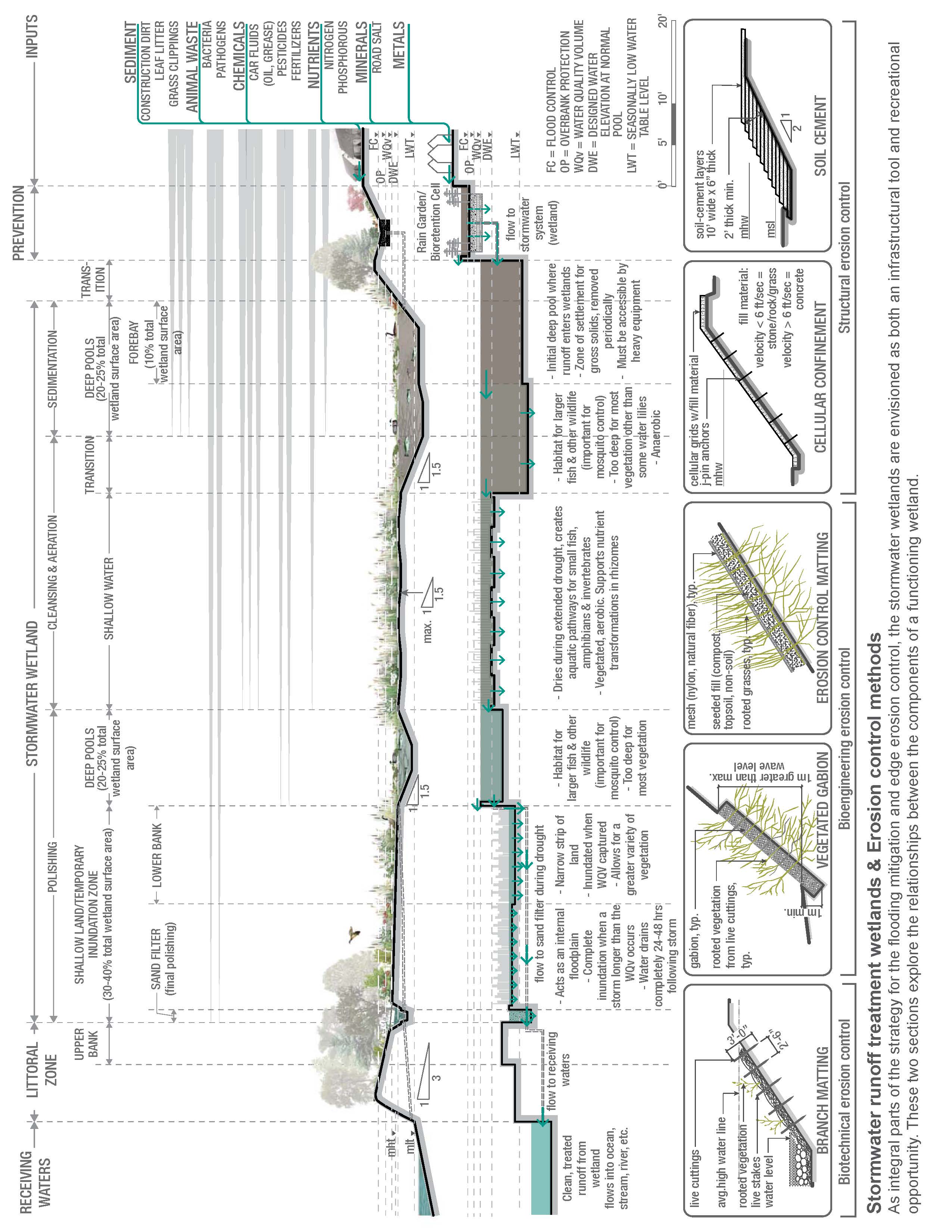
Stormwater Runoff Treatment Wetlands and Erosion Control Methods. As integral parts of the strategy for the flooding mitigation and edge erosion control, the stormwater wetlands are envisioned as both an infrastructural tool and recreational opportunity. These two sections explore the relationships between the components of a functioning wetland.
Download Hi-Res ImageImage: Melissa S. How
Image 9 of 15
 Close Me!
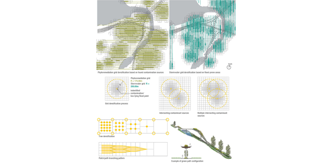
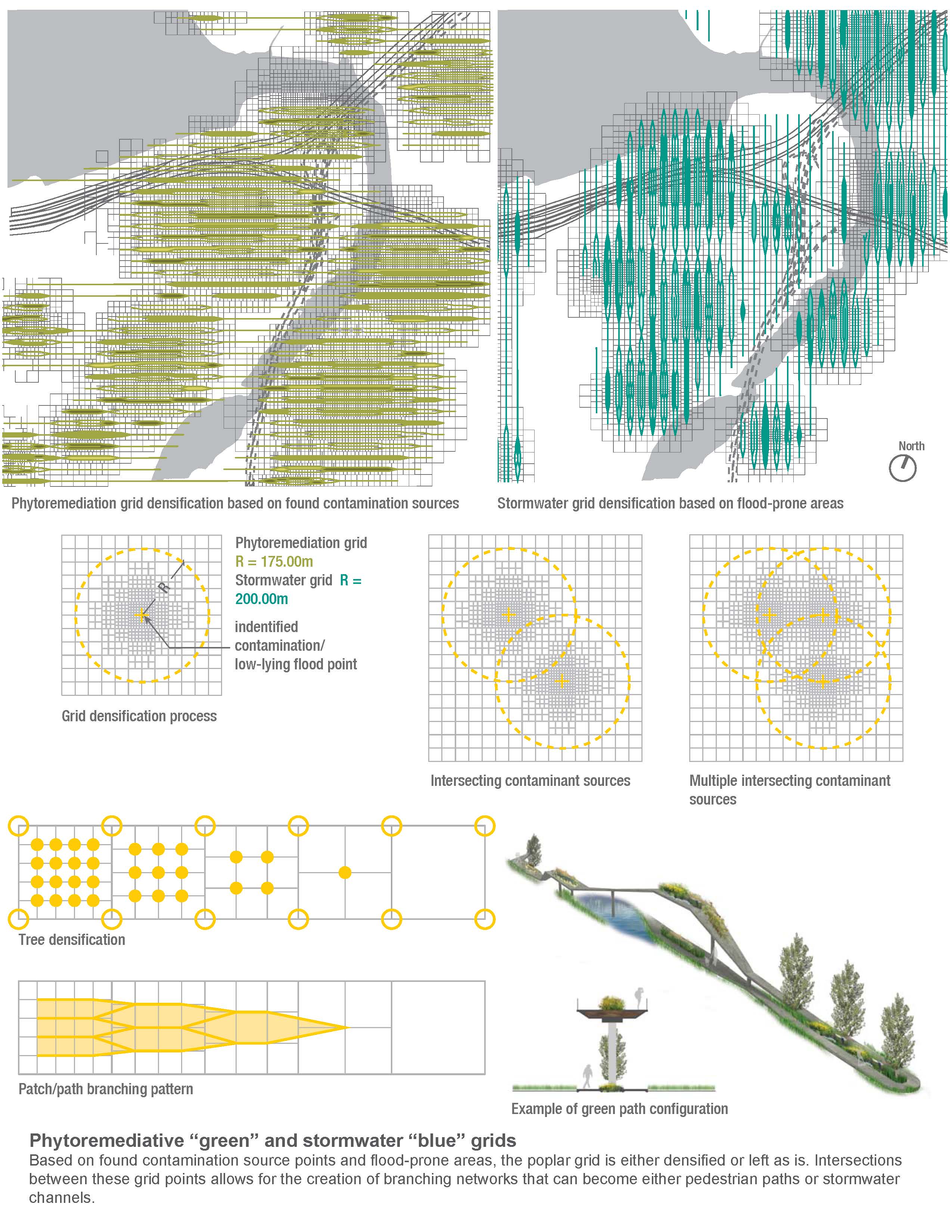
Phytoremediative "Green" and Stormwater "Blue" Grids. Based on found contamination source points and flood-prone areas, the poplar grid is either densified or left as is. Intersections between these grid points allows for the creation of branching networks that can become either pedestrian paths or stormwater channels.
Download Hi-Res ImageImage: Melissa S. How
Image 10 of 15
 Close Me!
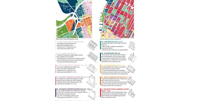
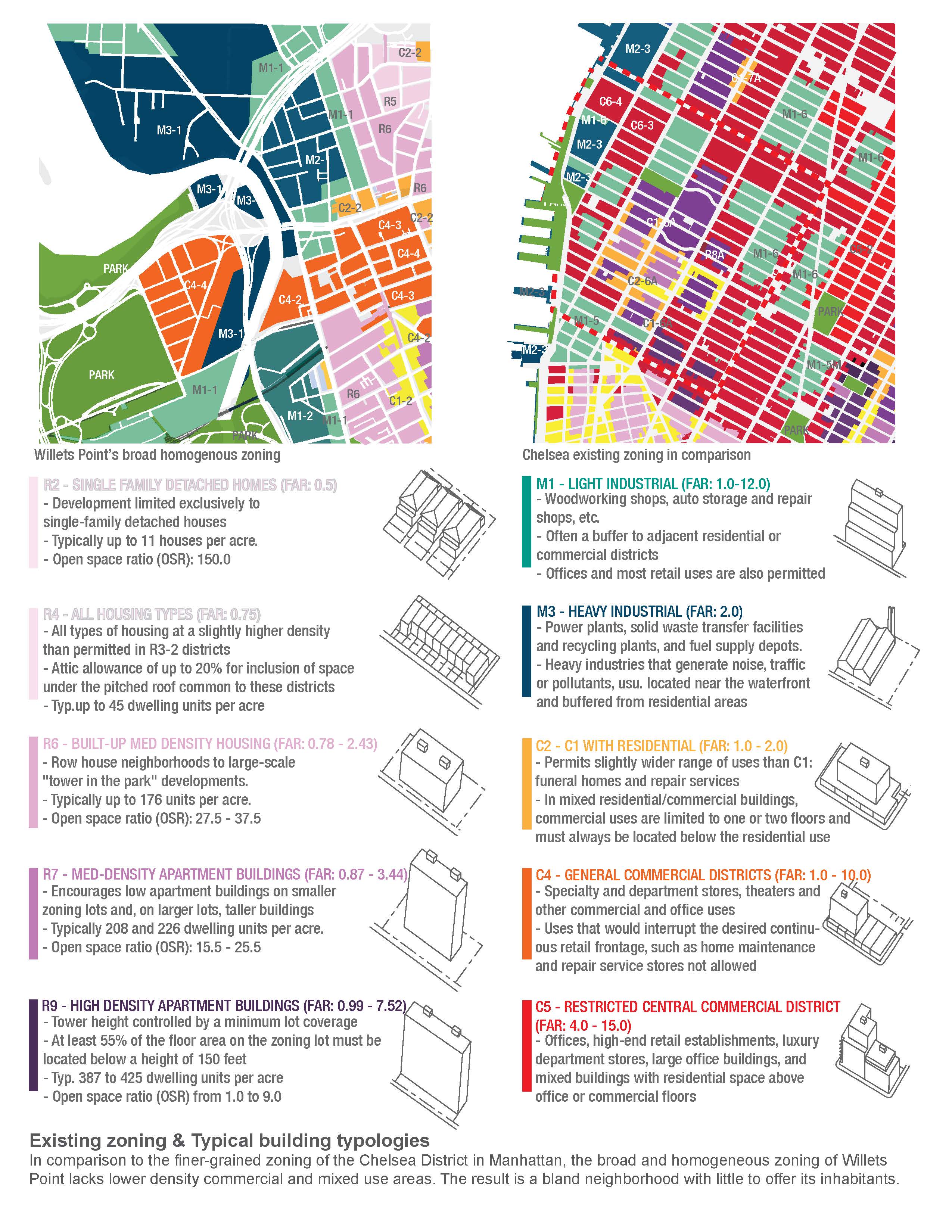
Existing Zoning and Typical Building Typologies. In comparison to the finer-grained zoning of the Chelsea District in Manhattan, the broad and homogeneous zoning of Willets Point lacks lower density commercial and mixed use areas. The result is a bland neighborhood with little to offer its inhabitants.
Download Hi-Res ImageImage: Melissa S. How
Image 11 of 15
 Close Me!
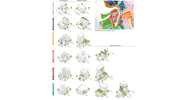
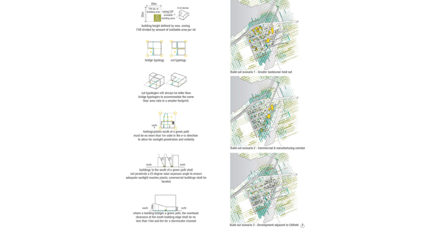
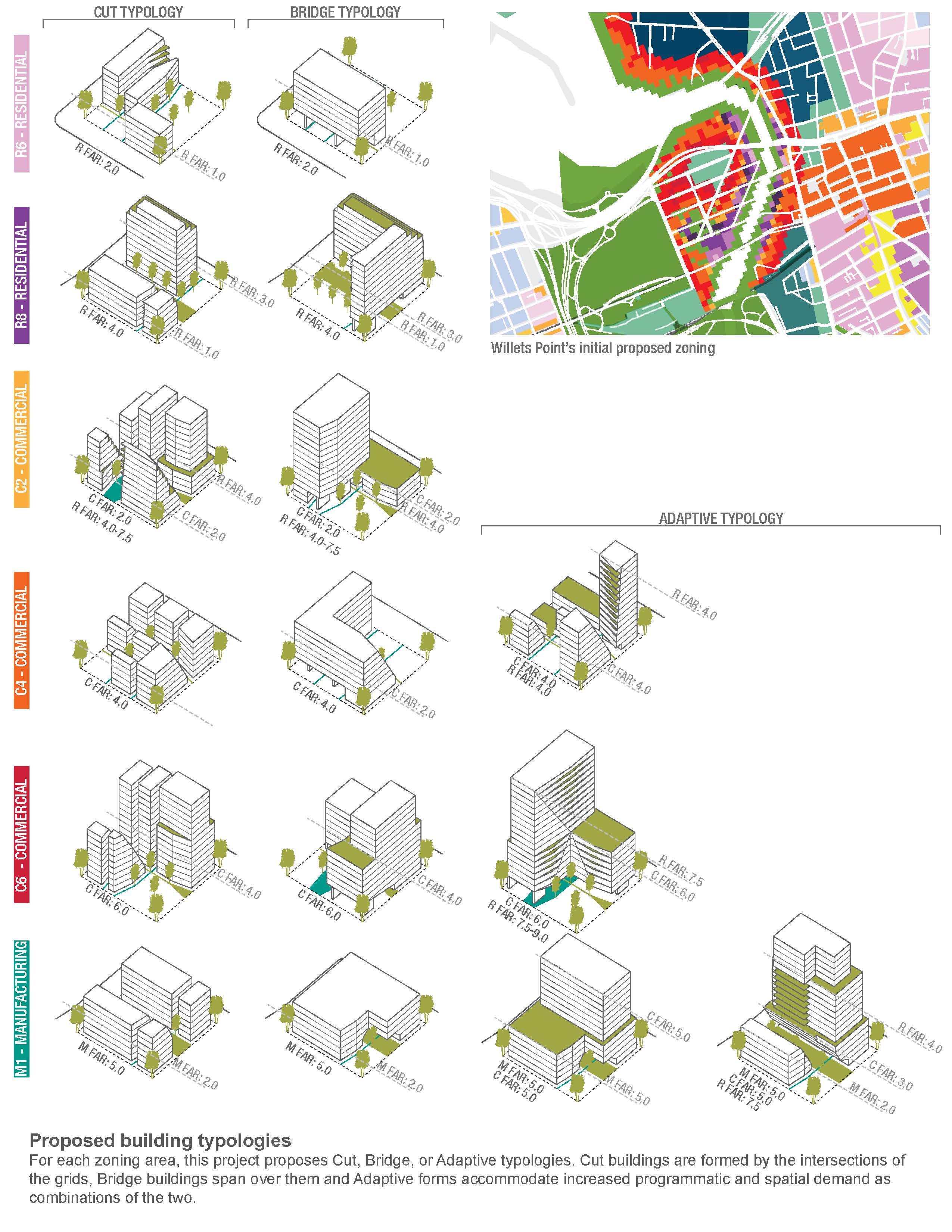
Proposed Building Typologies. For each zoning area, this project proposes Cut, Bridge, or Adaptive typologies. Cut buildings are formed by the intersections of the grids, Bridge buildings span over them and Adaptive forms accommodate increased programmatic and spatial demand as combinations of the two.
Download Hi-Res ImageImage: Melissa S. How
Image 12 of 15
 Close Me!
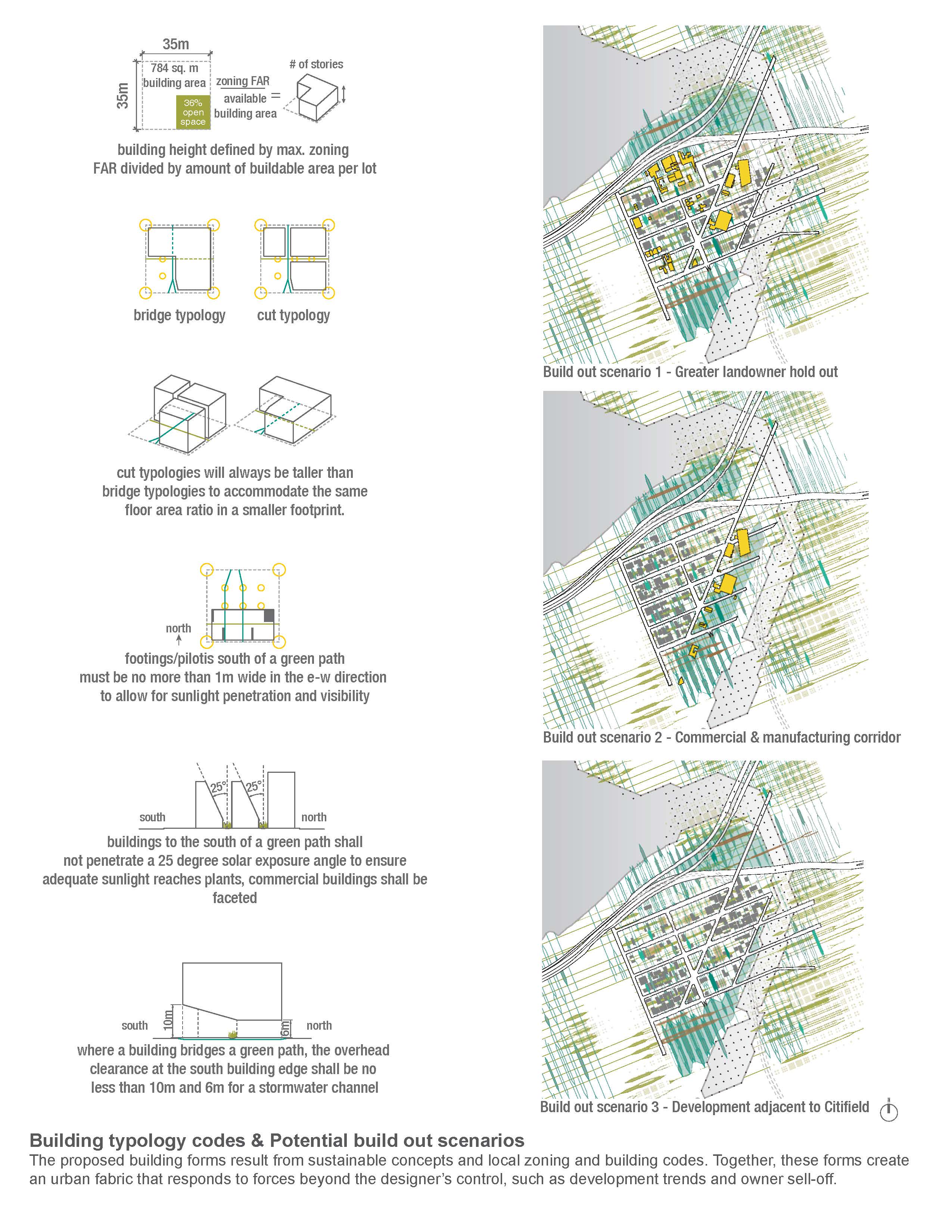
Building Typology Codes and Potential Build Out Scenerios. The proposed building forms result from sustainable concepts and local zoning and building codes. Together, these forms create an urban fabric that responds to forces beyond the designer's control, such as development trends and owner sell-off.
Download Hi-Res ImageImage: Melissa S. How
Image 13 of 15
 Close Me!
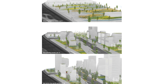
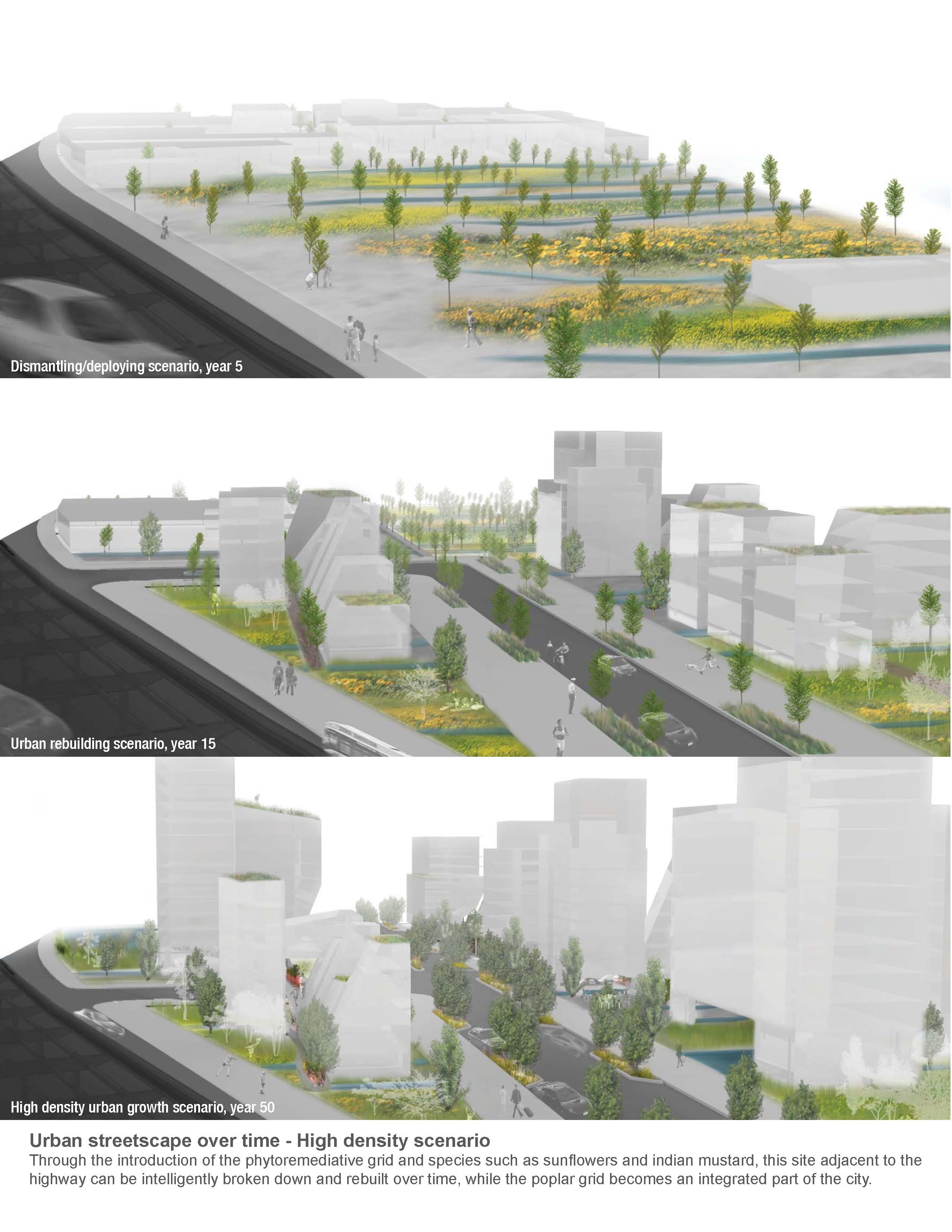
Urban Streetscape Over Time — High Density Scenario. Through the introduction of the phytoremediative grid and species such as sunflowers and indian mustard, this site adjacent to the highway can be intelligently broken down and rebuilt over time, while the poplar grid becomes an integrated part of the city.
Download Hi-Res ImageImage: Melissa S. How
Image 14 of 15
 Close Me!
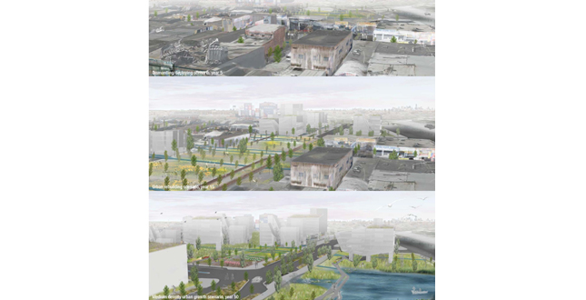
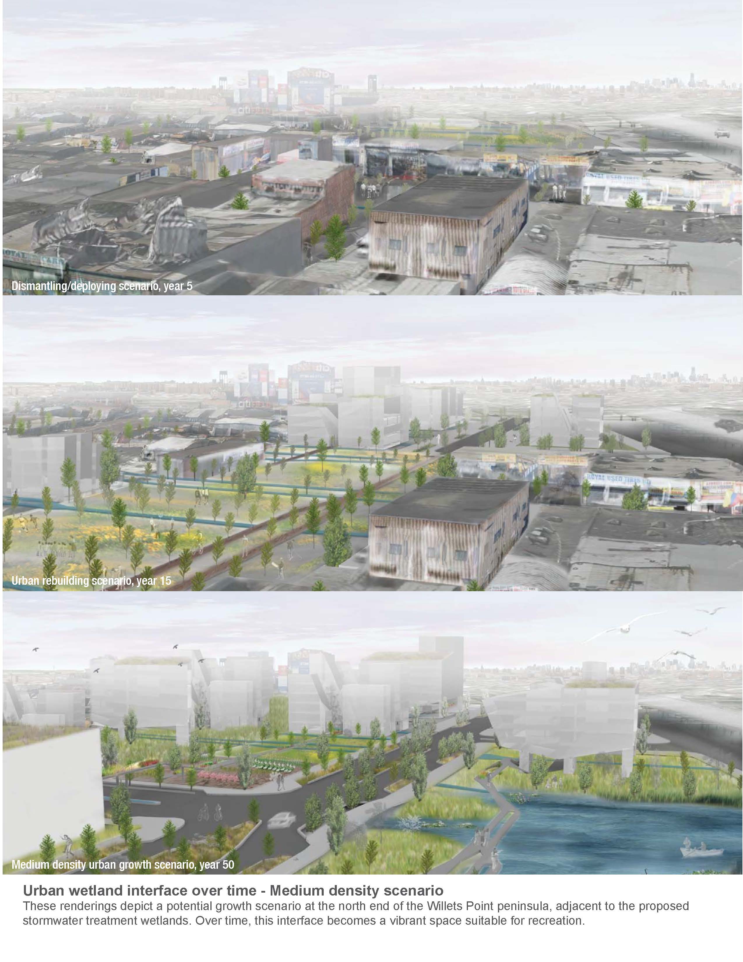
Urban Wetland Interface Over Time — Medium Density Scenario. These renderings depict a potential growth scenario at the north end of the Willets Point peninsula, adjacent to the proposed stormwater treatment wetlands. Over time, this interface becomes a vibrant space suitable for recreation.
Download Hi-Res ImageImage: Melissa S. How
Image 15 of 15
Project Statement
Focusing on the responsive integration of landscape and urban form, this project proposes a new vision for the highly polluted and politically contested Willets Point peninsula in Queens, New York. Based on land ownership patterns and levels of contamination and flooding as determined by a phytoforensic grid of hybrid poplar trees, existing lots are dismantled and critical infrastructural systems are deployed, spawning new landscape typologies and urban organizations that are uniquely suited to a marginalized urban environment.
Project Narrative
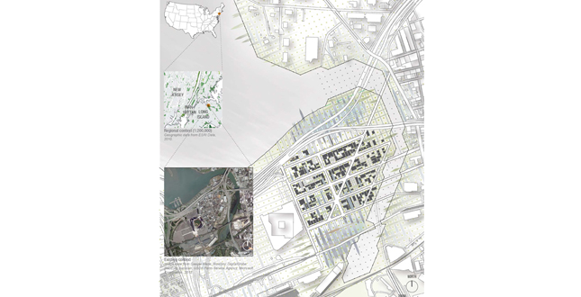
The project site is a 62 acre peninsula known as Willets Point, bounded by Flushing River to the east, Citi Field Stadium (home of the New York Mets) to the west and located just north of the Flushing Meadows 1939 & 1964 World's Fair site in Northern Queens, New York. Approximately 8 miles east of Manhattan, the site is home to dozens of ad hoc corrugated metal automotive sheds and numerous heavy industrial and manufacturing companies. The striking resemblance of the landscape to a third world shantytown is at once remarkable and disorienting, and a long legacy of municipal neglect aimed at driving out existing landowners has transformed the area into the quintessential urban brownfield. Conflicts between a redevelopment-minded city (which owns an estimated 35% of the land in Willets Point) and landowner businesses (collectively owning 46% of the land) struggling to survive under the constant threat of eminent domain have come together to create an urban wasteland with severely limited stormwater and sanitary infrastructure. Further exacerbated by a high water table, the site suffers from heavy petroleum, paint, cleaning solvent, and automotive fluid contamination from its tenant industries. This contamination is so widespread that it is virtually impossible to document or treat cost effectively with conventional methods, such as soil excavation or irradiation, which require great inputs of energy and money.
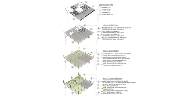
In order to mitigate this contamination and set in motion the process of sensitively dismantling and systematically rebuilding the site, this project proposes the strategic deployment of a grid of salt-tolerant, DN-34 hybrid poplars. These poplar trees will act as phytoforensic tools to allow the mapping of contaminants and their respective concentration levels existing while simultaneously remediating the petrochemicals in the soil through the process of phytodegradation. Derived from the measurements of the existing 230' wide street blocks of Willets Point, this 115'x115' poplar grid also acts as a hydrologic pumping mechanism, decreasing flooding and increasing shade and vegetation across the peninsula. A decision-making framework based on a series of "If/Then" scenarios predicated on ideas of succession and management then guides future projections and site strategies in response to feedback received from the grid. For example, the "green" (or phytoremediative) grid might be densified if a particular cell shows high levels of contamination. Conversely, another cell that fails to respond to phytoremediation might require greater intervention and be capped with clean soil. Concurrently, existing building lots would be dismantled and reprogrammed in accordance to changing land ownership patterns and holdout tendencies, allowing for multiple development scenarios to operate across time within a dynamic and adaptive framework that generates multi-scalar civic change.
Whereas the densification of the "green" grid occurs based on the locations and levels of contamination identified by the initial poplar deployment, the densification of a stormwater grid might occur based on existing locations of low-lying flood prone areas. The variation in cell densities within each system allows opportunities for the creation of branching pathways to be constructed. In the "green" system, these pathways might become vegetated pedestrian and bicycle pathways that can vary dynamically by bisecting or puncturing buildings, and splitting or changing in materiality or elevation. Within the stormwater, or "blue" system, these pathways might become productive stormwater channels that carry runoff through the site and into two stormwater runoff treatment wetlands at the north and south of the peninsula. Where the two systems overlap, bioswales or vegetated detention ponds are created that can hold and clean water prior to infiltrating it back into the aquifer below the site.
Similarly, the urban fabric is imagined as its own type of ecological system, where its formal language is defined not only by traditional city rules (such as zoning, easements, or floor area ratios), but also by the needs of the broader ecological, environmental, infrastructural, and social-cultural processes at play. Upon inspection, the existing broad and homogenous zoning of Willets Point contrasts with the finer grained heterogeneity of vibrant New York communities, such as the Chelsea District in Manhattan's West Side. In order to bring this vitality to Willets Point, it is necessary to establish a more differentiated and pixelated zoning plan as a basis for urban development. Open vegetated spaces (for leisure, recreation and wildlife habitat) were privileged and calculated based on each cell's proximity to the coastline and city owned lots, which represent opportunities to reclaim public open space. The amount of open space per lot in turn correlates to a series of desirable land uses (such as residential, commercial, entertainment, office, and light manufacturing), suggesting zoning and land use patterns that exemplify greater diversity and mutability over time. Three building typologies are defined: the Cut typology (in which built form is defined by the green and blue pathways), the Bridge typology (in which built form spans across the pathways), and Adaptive typology (a hybrid of the Cut and Bridge typologies that is repurposed by the addition, renovation, or subtraction of building mass).
Thus, "Dismantle/Rebuild: A New Framework for Willets Point" explores the relationship between the built environment, the successional urban "forest" and its accompanying interspecial and opportunistic vegetation, as well as human and hydrological movement. Guided by the feedback from the poplar tree grid and the scenarios developed in the If/Then framework, the resulting city can take on a multitude of configurations. By responding to variable inputs such as fluctuations in the number of private landowners who do not wish to sell or development trends, an intelligent and resilient city is developed that can accommodate increasing or decreasing spatial demands over time without sacrificing character or richness. At its finest scale, the city transforms over time from an existing landscape of unpaved streets and temporary buildings into a complex system in which the site's history as a contaminated and politically charged site is expressed within a nuanced and vibrant streetscape. While most traditional cities are founded on principles of stability and permanence that are paradoxically forgotten, erased, or built over in response to change, this project demonstrates that by operating under the assumption that change is a given, long-term viability can be ensured and the city made truly sustainable.