


Award of Excellence
UPGRADE / RETROFIT: Strategies for
Re-Urbanization of Haiti's Hillsides
Jeff Powers, Student ASLA and Byron White, Student ASLA, University of Toronto
Faculty Advisor: Liat Margolis
 Close Me!
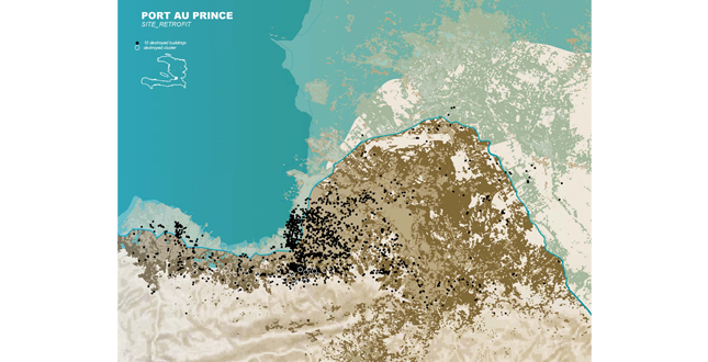
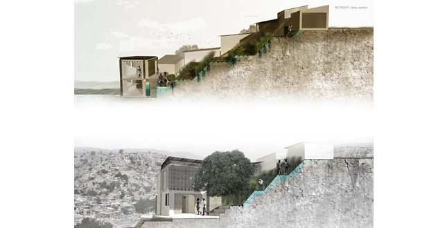
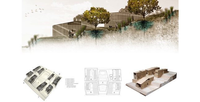
Port Au Prince. Site Retrofit
Download Hi-Res ImageImage: Jeff Powers and Byron White
Image 1 of 16
 Close Me!
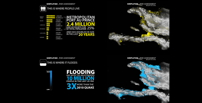
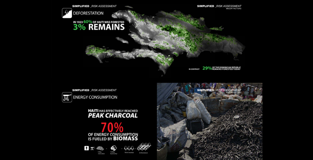
Simplified — Risk Assessment.
Download Hi-Res ImageImage: Jeff Powers and Byron White
Image 2 of 16
 Close Me!
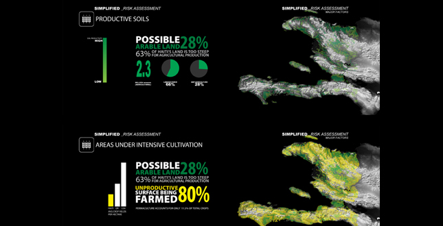
Simplified — Risk Assessment.
Download Hi-Res ImageImage: Jeff Powers and Byron White
Image 3 of 16
 Close Me!
Simplified — Risk Assessment.
Download Hi-Res ImageImage: Jeff Powers and Byron White
Image 4 of 16
 Close Me!
Simplified — Risk Assessment.
Download Hi-Res ImageImage: Jeff Powers and Byron White
Image 5 of 16
 Close Me!
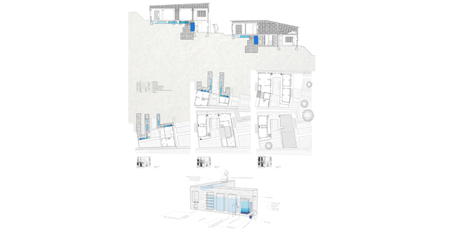
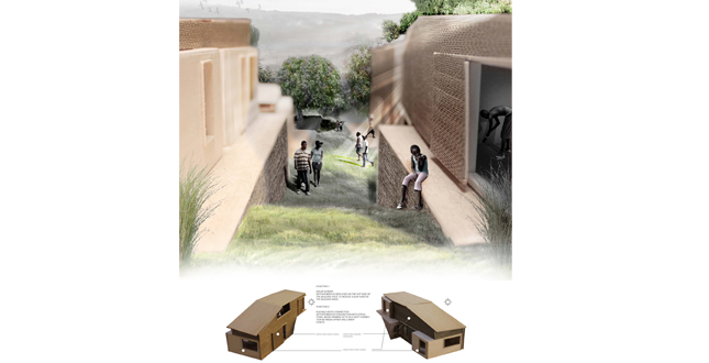
Retrofit: Shared Infrastructure
Download Hi-Res ImageImage: Jeff Powers and Byron White
Image 8 of 16
Project Statement
UPGRADE/RETROFIT is an hybridized architectural and landscape design plan that envisions a new possibility for Haiti's development beyond the short term disaster relief solutions currently in use. The earthquake that struck Haiti in 2010, was another chapter in a series of events that have systematically destroyed the Haitian landscape and communities. Within the current framework for redevelopment, sustainable systems are not adequate. Instead, we envision a strategy for rehabilitation, augmentation and surplus.
Project Narrative
—2011 Student Awards Jury
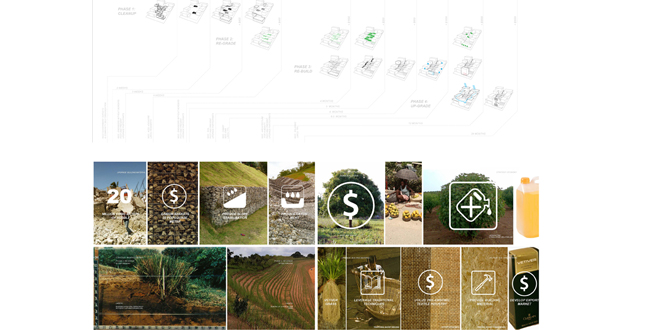
This project began as an investigation of the environmental degradation within Haiti, and its relationship to human development. Out of it, we developed a two phase system that incorporates traditional community structure in a new urban paradigm and employs naturally augment infrastructural systems.
Haiti's population has outstripped its resources, and it is becoming increasingly difficult to sustain modern society. As the industrialized world continues to increase its consumption, these effects will be felt on a larger and larger scale. We propose a strategy that is not simply a net zero system, but can provide surplus outputs that result in a accelerated rehabilitation scheme.
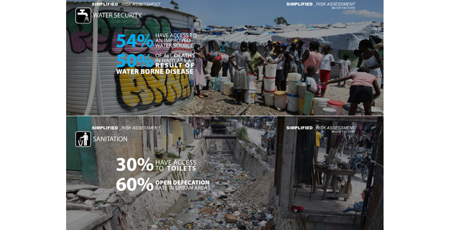
The myriad of problems plaguing Haiti are well documented. It is the poorest nation in the western hemisphere, and consistently ranks at the bottom of the Human Development Index. Natural disasters, such as flooding and hurricanes occur regularly. The country has been deforested for energy production, which has further magnified the effects of flooding and hurricanes. The agricultural sector has been decimated by natural disasters and unsustainable food importation policies. As a result Haitian caloric intake remains one of the lowest in the western hemisphere. Potable water access and sanitation levels are extremely low. Moreover, due to widespread government corruption, adequate infrastructure and programs to alleviate these risks are difficult to realize.
Utilizing data from GIS, and USAID's environmental assessment we isolated a number of conditions that are currently prohibiting redevelopment. Due to the mountainous nature of the country, Haiti's population tends to reside in flat areas, which are also low lying and extremely flood prone. These flat, flood prone areas have the most agricultural potential, but have been encroached by urban expansion. To appropriate the necessary agricultural land and to provide charcoal for energy, the hillsides have been deforested. This deforestation has increased sedimentation in the watershed system compounding flooding and contaminating water supplies. The proposed solution is to move the population off the flood plains to provide safety and reestablish an agricultural economy in the alluvial plains. This expansion must occur on the steeper slopes of the mountainsides, as the foothills have already been built upon. This new urban fabric is then upslope/upstream from existing development, and is an opportunity to provide necessary infrastructure and services for the population and provide an urban riparian buffer to facilitate the rejuvenation of the watersheds and environment.
To achieve this we looked at existing and historical models of social clustering as a method of leveraging grouping to achieve efficiencies, economies of scale, and further promote ideas of community. We focused on the lakou (which means "courtyard" in Creole). It was a common rural clustering method that rose from the Haitian War of Independence. The lakou is comprised of 5–7 homes of multiple families, of both biological and non-biological kin that surround a communal courtyard and are encircled by a garden. These lakous were set up as a method of agricultural self-reliance. Based on the African system of multiple mothering, the lakou system allows for support between families, yet families are agriculturally independent, with each household maintaining responsibility for their own landholdings outside the lakou proper. The courtyard of the lakou is a space of worship for all Haitian religions, a gathering place for socializing, and a political arena.
The increasing fragmentation of landholdings due to population growth, and urban emigration caused the lakou structure to disintegrate in the mid-twentieth century. Urban clustering occurred naturally, but the cooperative support system gave way to the nuclear family. However, in the post-earthquake relief camps, echoes of the lakou structure are resurfacing as families cluster for safety and support under the unified space of the tent. The inherent cooperative nature of the lakou structure can be leveraged in multiple scales as a tool to roll out redevelopment to the population.
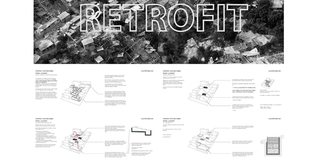
The earthquake provided another challenge to the design proposal. As previously stated, the opportunity for a re-urbanization plan lay in areas of steep slopes, above the current elevations that are currently being occupied. The earthquake devastated many of the existing houses on the slopes. In order to viably expand the urban centers up the mountains and maintain connection to the historical centers that are typically on the low lying flat plains, the existing hillsides development needed to be re-knit.
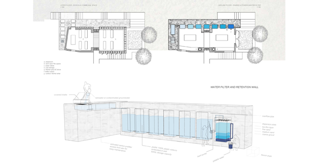
Thus the proposal for this phase, the RETROFIT, is to leverage two problematic outputs of the earthquake, the destroyed urban pockets and immense amounts of concrete rubble, into tools to reestablish the landscape and establish social clusters. The process identifies destroyed clusters, and utilizes the rubble from these clusters to create multiple gabion French drains calibrated to the size of the cleared pocket. The cleared area is then geo-terraced by using vetiver grass. The terrace pads are big enough to provide a household garden capable of providing 10% of the family's food, but small enough to discourage further building of informal structures. On the gabion drains, further infrastructural amenities are inserted. On the upslope, a dry toilet is provided by leveraging existing NGO programs currently in place. At the larger down slope gabion drain location, an infrastructural water wall is built to provide the means to collect, store and filter enough water for the surrounding lakou community. This wall can be further leveraged by building a communal cooking area with fuel efficient stoves, as well as a larger classroom space for the young population. This centralized social hub provides a physical space to aid in community healing and engagement.
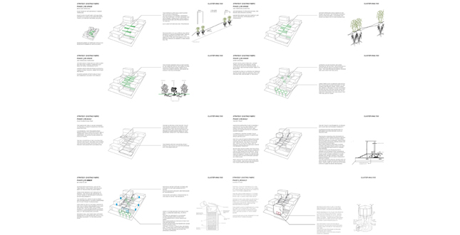
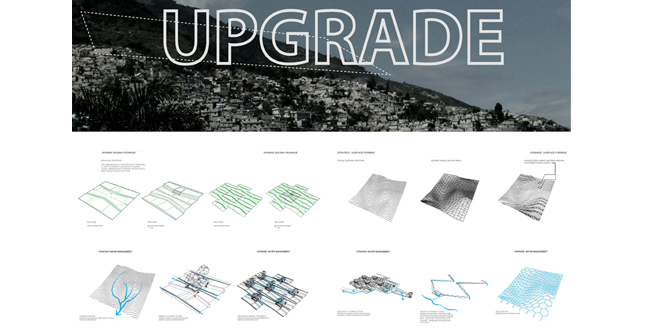
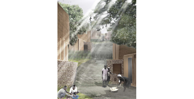
The second phase, THE UPGRADE which occurs on the steeper slopes above the existing fabric, utilizes many techniques established in the retrofit. Vetiver grass is used to geo-engineer the landscape to provide suitable building slopes across a much steeper overall slope. The water management system directs the runoff towards a central catchment hub (a new lakou space) where mango trees are planted to reduce water loads and provide a cash crop to the residents. The overflow is split, redirecting water along natural swales to the adjacent lakou catchments, which helps to distribute the water loads across a larger area, while simultaneously providing a natural irrigation system.
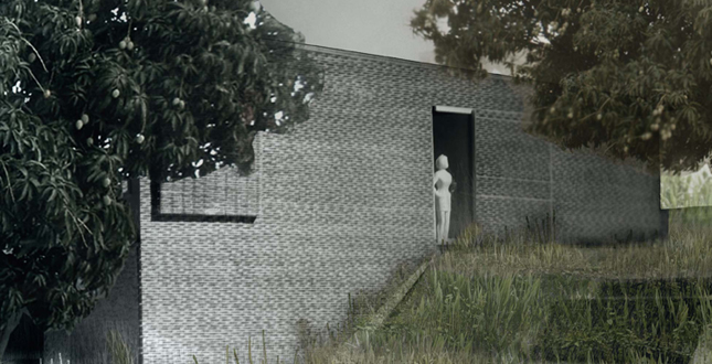
Architecturally, the plan utilizes the infrastructural water wall in a similar manner. The UPGRADE, aims to reduce urban density in order to exponentially increase landscape productivity. The homes are larger, and designed to provide the space and infrastructure for an entire extended family. The construction is a combination of seismically stable confined masonry, and light frame timber construction. Timber is scarce as a result of deforestation, and would be donated as part of the Aid packages. It is needed to stimulate a economically viable agro-forestry solution that could begin to reforest the country. This same strategy is used for the solar shading screens, which are woven from the cuttings of the slope stabilizing vetiver grasses.
Additional Project Credits
We would like to thank Liat Margolis for her unending support and guidance during the thesis. We would also like to thank David Lieberman and Robert Wright who were generous with their time and expertise.