


Honor Award
Gateways Through Gesture The Philadelphia Handshake Connecting North Philadelphia to the Delaware River
Abigail Happy Smith, Student ASLA, Graduate, University of Pennsylvania
Faculty Advisors: Lucinda Sanders, FASLA; TAs Michael Miller and Edward Confair, Associate ASLA
 Close Me!
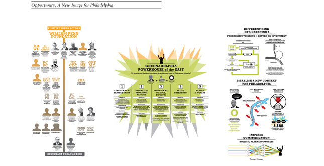
Analysis: Opportunity: A New Image for Philadelphia
Download Hi-Res ImageImage: Abigail Happy Smith
Image 4 of 13
 Close Me!
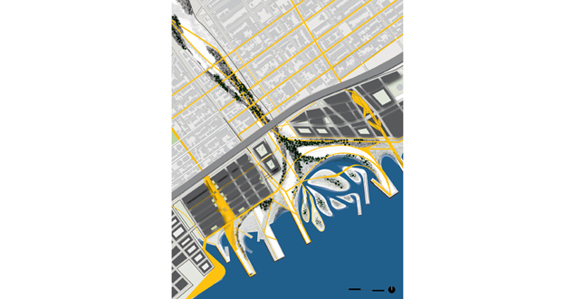
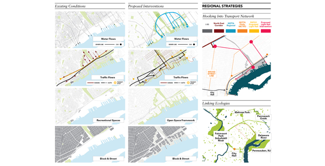
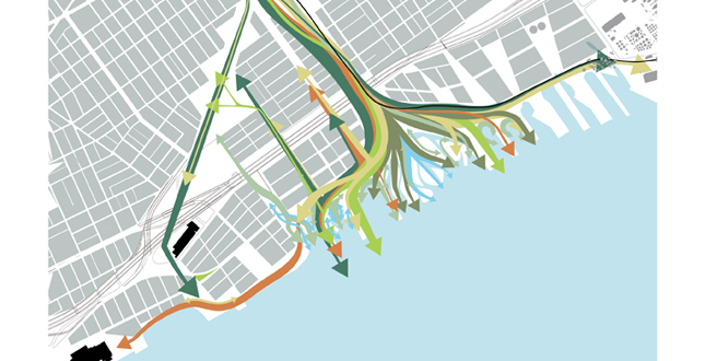
Regional Strategies: Left: Existing Conditions. Middle: Proposed Interventions. Right: Hooking Into Transport Network
Download Hi-Res ImageImage: Abigail Happy Smith
Image 5 of 13
 Close Me!
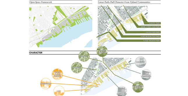
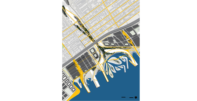
Neighborhood Strategies: Left: Open Space Framework. Right: Linear Parks Pull character from Upland Communities. Below: Character
Download Hi-Res ImageImage: Abigail Happy Smith
Image 6 of 13
 Close Me!
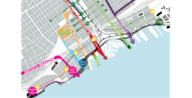
Promoting the unique soical character of neighboring communities.
Download Hi-Res ImageImage: Abigail Happy Smith
Image 7 of 13
 Close Me!
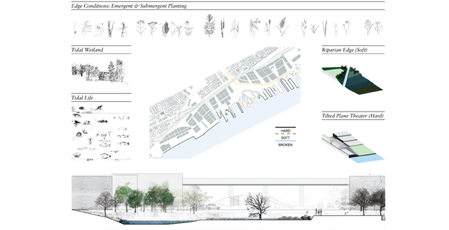
Ecological Strategy: Edge Conditions: Emergent and Submergent Planting
Download Hi-Res ImageImage: Abigail Happy Smith
Image 8 of 13
 Close Me!
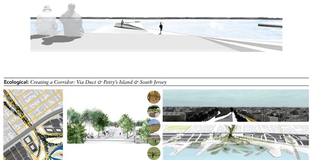
Top: Place Making. Bottom: Ecological: Creating a Corridor: Via Duct and Petty's Island and South Jersey.
Download Hi-Res ImageImage: Abigail Happy Smith
Image 12 of 13
 Close Me!
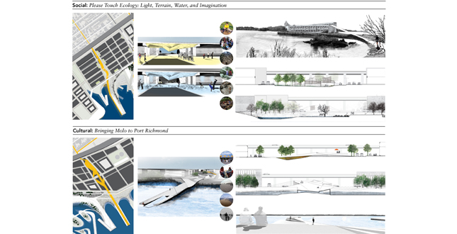
Top: Social: Please Touch Ecology: Light, Terrain, Water, and Imagination. Bottom: Cultural: Bringing Molo to Port Richmond
Download Hi-Res ImageImage: Abigail Happy Smith
Image 13 of 13
Project Statement
By tapping into the unique culture of neighboring communities as well as providing program along the water's edge this strategy is both sensitive to existing conditions while promoting forward thinking & ecologically sound development.
A combination of gateways + linear parks stretch along the piers pulling residents and visitors to what is currently a neglected waterfront. To establish these connections, the public must feel invited. This concept proposes thresholds under I-95, a robust ecological corridor, visibility, and lively neighborhoods.
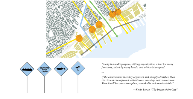
"A city is a multi-purpose, shifting organization, a tent for many functions, raised by many hands, and with relative speed.
If the environment is visibly organized and sharply identifies, then the citizens can inform it with his own meanings and connections. Then it will become a true place, remarkable and unmistakable."
—Kevin Lynch "The Image of the City"
Project Narrative
—2011 Student Awards Jury
Introduction
Philadelphia has a history of an old boys club attitude towards policy. Since coming into office, Mayor Michael Nutter has been shaking things up. In 2010 his office released a Philadelphia2035: Comprehensive Plan Citywide Vision, which was rooted in objectives found in the 2009 Greenworks Plan. Inspired by the momentum Nutter has gained by using Philadelphia’s urban form to address ecological issues such as climate change this proposal attempts to fall in line with his agenda while inspiring stewardship and community.
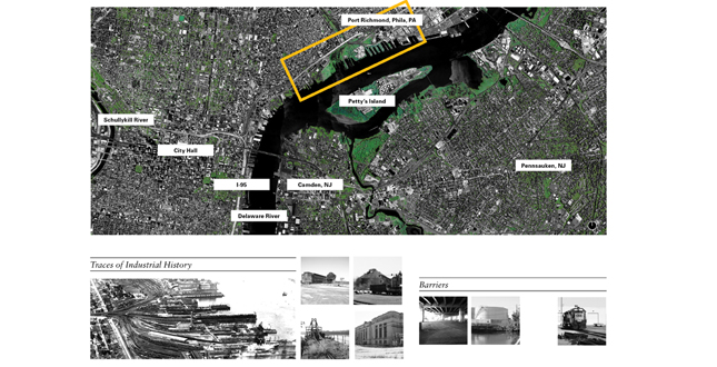
The topology found along this site is primarily industrial relics from a time when the city generated a substantial economy with this waterfront. Adjacent neighborhoods are composed of a dense rowhouse stock. Decaying manufacturing industries along the river has provided an abundance of under utilized and centrally located land. Many households do not own a car, reducing access to fresh healthy food. The transition of former industrial land to other uses raise questions of compatibility. There is a desire for better access to public transportation, and a healthy accessible waterfront.
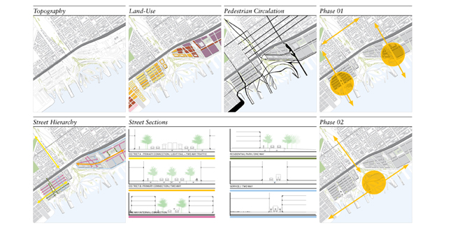
The process for design was to draw upon research through iterative plans, models, and views. This was then evaluated by a series of conversations and reviews. Options were considered and evaluated by contextual connection, ecological service, and economic feasibility. The project was to be phased through 2 stages. First stage would be to stabilize programmatic anchors on either end of the site, connect into traffic from I-95 exits, erode significant edges along the Delaware River, prepare piers for development, carve recreation circuit along water’s edge and viaduct which would include access points from upland neighborhoods to viaduct, set ground work for residential and commercial cores, introduce 2 light rail transit stops. The second phase would be complete infill of residential and commercial cores, I-95 threshold interventions, two additional light rail transit stops.
Goals
- Create an identity for the waterfront that will become a source of civic pride
- Connect with regional usage
- Generate a compelling narrative to share with the public and investors
- Create spectacle and variety along the water’s edge
- Engage the health of upland communities known as the River Ward District.
- Generate block and massing at a scale appropriate for the context
- Design identifiable places that people will use and take pride in.
Objectives
- Understand the proposals that are on the table
- Integrate ecological, social, economic, and cultural basis for the improvement of the living environment.
- Gain an understanding for the pros and cons of the planning culture in Philadelphia
- Close the economic gap by introducing land-use that will maximize activity and minimize subsidy.
- Propose land-use that will move the city in an ecological direction
- Understand how landscape structures urban form, activity, ecology, and economy
Analysis
The objective of the analysis was to understand how site was embedded in a network of systems ranging from environmental, political, social, economic, and urban. This resulted in a programmatic methodology driven by landscape as a structuring device for urban form. In addition appropriate land-use and scale were a priority.
The following is an outline of steps taken to understand this system:
- Read and diagram proposals on the table with the goal to propose an enlightened narrative for placemaking.
- View the problems through multiple lenses, the developer, neighbor, council member, designer, ect.
- Visit the site over and over again. Photograph, sketch, and record.
- Interview community neighbors inquire about the culture of place and demographic.
- By mapping, investigate how the site connects into a regional network of culture, ecology, and transportation.
- Use archives to research site history.
- Sift articles written by local architecture critic, Inga Saffron, to gauge architectural climate.
- Interview developer Bart Bladstien who was praised by Saffron about neighboring Piazza development.
- Conduct urban prototype studies focus on territorial, residential, integrated big-box / large format footprint typologies
- Follow Richard Foreman’s idea of ecological corridor, matrix, by mapping regional ecological patterns.
- Read topographic survey and run-off analysis.
- Study the nature of rivers. In particular gain a close read on conditions that cause, deposition, sedimentation, deformation, and flooding. Generate sectional diagrams of these phenomena.
- Chart tidal flux of the Delaware River.
- Understand the phasing for a tidal marsh to develop.
Additional Project Credits
Prenn Praxis
Harris Steinberg
PennDesign
David Gouverneur
Research Collaborators
Rebecca Lederer, Student ASLA, Minyoung Choi, and Ekta Gupta