


Award of Excellence
Tempelhof Wasserpark
Johanna F. Barthmaier, Associate ASLA, Graduate, University of Pennsylvania
Faculty Advisors: Martin Rein Cano and Yadiel Rivera Diaz
 Close Me!
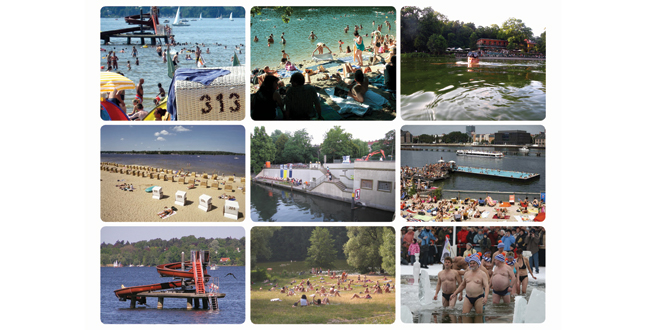
Berlin Lake and Water Culture — The city of Berlin is surrounded by two lake chains, the Havel and the Spree, and boasts more than twenty natural and man-made lakes accessible by public transit. In the warmer months these bodies of water are an important part of Berlin’s recreational culture, attracting diverse crowds to swim and socialize.
Download Hi-Res ImageImage: Johanna F. Barthmaier
Image 2 of 15
 Close Me!
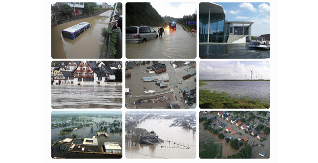
High Ground Water and Storm Water Flooding — Because of its location in a swamp laden glacial valley, Berlin is under a constant threat from water-caused destruction. When combined with frequent storm events, the water table rises causing the city and nearby agriculture to flood. In most cases storm water is captured in underground reservoirs or sewerized for processing, but the system is frequently overwhelmed by large amounts of water. A new system that relies on capturing and filtering storm water can help alleviate this problem.
Download Hi-Res ImageImage: Johanna F. Barthmaier
Image 3 of 15
 Close Me!
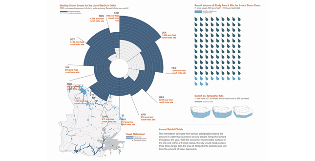
Annual Rainfall Totals — The information collected from annual precipitation shows the amount of water that is present on and around Tempelhof airport throughout the year. With the amount of impermeable surface on the site and within a 6-block radius, the city would need a space three times larger than the area of Tempelhof to facilitate and infiltrate the amount of water deposit.
Download Hi-Res ImageImage: Johanna F. Barthmaier
Image 4 of 15
 Close Me!
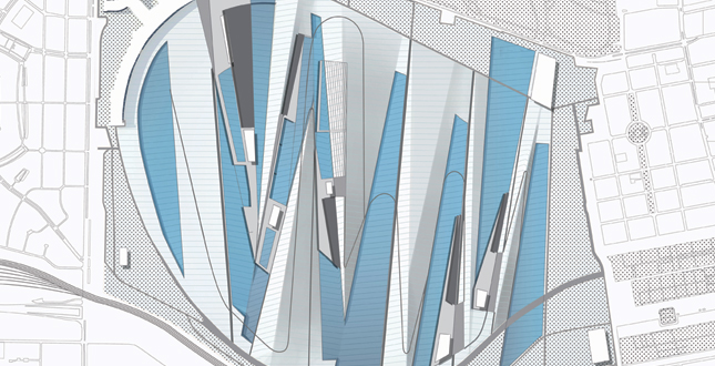
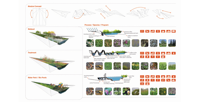
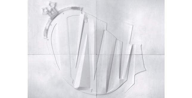
The Module Concept — The water collection module was inspired by the form of a paper airplane. With its faceted surfaces and folds, the light-hearted and historically contextual form was adapted into landforms to facilitate the movement and collection of water.
Download Hi-Res ImageImage: Johanna F. Barthmaier
Image 5 of 15
 Close Me!
Function of Water — The faceted surfaces of the paper airplane were redefined into a system of pools of specific volumes and filled landforms to move water through a three-step filtration system. Depending on the weather, the ephemeral movement of water around the design sets the stage for unique recreational programs to develop and helps manage water while informing visitors about the local hydrology.
Download Hi-Res ImageImage: Johanna F. Barthmaier
Image 6 of 15
 Close Me!
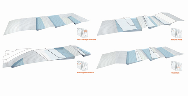
Sections — Water is moved and collected by landforms that define pools with hard and soft edges, acting as filter and overflow buffers. A series of floating decks, shade covers and viewing areas are used to facilitate swimming, education and maintenance.
Download Hi-Res ImageImage: Johanna F. Barthmaier
Image 9 of 15
 Close Me!
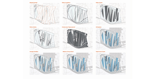
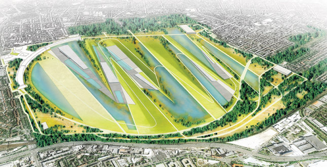
Illustrative Plan — The park is easily accessible to the surrounding neighborhoods and is connected to several existing park systems, tree-lined boulevards and cemeteries. Existing conditions and new implemented wetlands on the outer portion of the park serve as a main catchment area for water before it enters the site.
Download Hi-Res ImageImage: Johanna F. Barthmaier
Image 10 of 15
 Close Me!
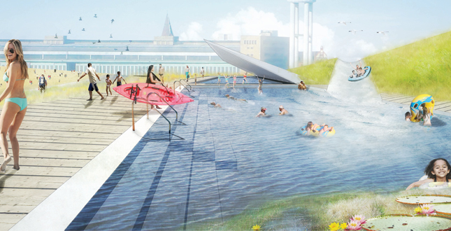
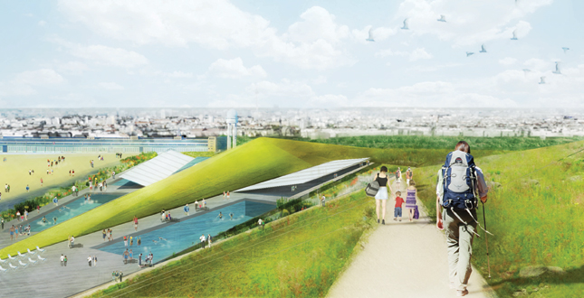
Natural Swimming Pool and Water Park — The water park is nestled into the folds of the landforms with a deck system that provides comfortable and safe water recreation while allowing water to flow and filter underneath.
Download Hi-Res ImageImage: Johanna F. Barthmaier
Image 11 of 15
 Close Me!
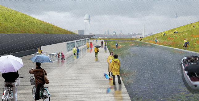
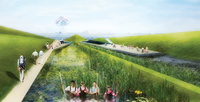
Treatment Pools During Rain Event — The pools which are not part of the water park function as treatment zones and allow for many types of recreation such as boating, hiking. This area also consists of facilities for research and public education about hydrology and ecology.
Download Hi-Res ImageImage: Johanna F. Barthmaier
Image 12 of 15
 Close Me!
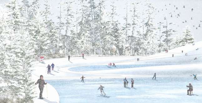
Treatment Pools During Snow Event — As the pools freeze in colder months, the park transforms to facilitate winter recreational activities.
Download Hi-Res ImageImage: Johanna F. Barthmaier
Image 13 of 15
 Close Me!
Treatment Pools for Education — The airport is transformed into a living classroom granting visitors access to the city’s hydrology as well as to ephemeral experiences within the landscape.
Download Hi-Res ImageImage: Johanna F. Barthmaier
Image 14 of 15
 Close Me!
Variation of Program — The rises in the landform create different vantage points of the site, provide areas and paths for recreation like skiing, hiking and include integrated water slides for the pools. The variation of landscape creates both large-scale and intimate spaces for a diverse range of activities.
Download Hi-Res ImageImage: Johanna F. Barthmaier
Image 15 of 15
Project Statement
Berlin, Germany lies close to the water table and with an overwhelming amount of annual rainfall, the city has more water than its infrastructure can handle. Tempelhof airport provides a clear open space inside the city to test a new form of water management in Berlin, where storm and ground waters are reserved, absorbed and filtrated through pools, plantings and landforms. A module based on the folds of a paper airplane helped generate the design, which allows water to move and collect throughout the site. Depending on the weather, the ephemeral movement of water sets the stage for unique programs to develop and informs visitors about the local hydrology.
Project Narrative
mark in the future. The form is elegant and it deals with contaminants from a decommissioned airfield site. It's more than just collecting water, it's treating the pollution.”
—2011 Student Awards Jury
Context & History
The project site is located in the European planes of Berlin, which are the northern glacial lake and swamp regions of Germany. The city has a temperate seasonal climate and receives over 120 rain and/or snow events per year. The glacial valley on which Berlin resides formed during the Ice Age and became a deposit for swamps and bogs flanked by the Havel and Spree lake chain. This created a very high ground water system measuring over 16 meters in depth. High ground waters combined with an immense amount of annual precipitation gives the city more water than it’s infrastructure can process. Under these circumstances, urban hydrology is taken very seriously, and in most cases storm water is captured in underground reservoirs or sewerized for processing.
Tempelhof airport is located just south of the city center and is home to some of the richest history of World War II. Built up by the Nazi Party in the late 1930s, the airport was taken over after the war by the Americans for the Berlin Airlift, which delivered goods to West Berlin, now cut off by Russian forces. Since the fall of the Berlin Wall, Templhof functioned as a commercial airport until 2010 when it was shut down for economic reasons and turned into a public space for the city. Easily accessed by public transport, the airport site is bordered by low-income Turkish neighborhoods and the lively Kruezburg section of the city.
Site
The 4-kilometer circular airfield now serves as a public space for the city and hosts a large array of impromptu programs and events. Two large runways built by the Americans in the 1950s correspond to strong east and west wind conditions. There is a large deteriorated path system used during Nazi rule that encircles the site and connects to primary and secondary entrances. To the north is the airport terminal, one of the largest structures in the built world. To the south is a community of allotted gardens and an elevated highway connection. With no reservoir or outlet, the main east and west connections of the site create natural low points where the intake of storm water frequently floods the central valley of the airfield.
Calculations of annual rainfall and the amount of impermeable surface on the site and within a 6-block radius, indicate that the city would need a space three times larger than the area of Tempelhof to facilitate and infiltrate the amount of water deposited.
Program
Tempelhof airport provides a clear open space inside the city to test a new form of water management in Berlin, where storm and ground waters are reserved, absorbed and filtrated through pools, plantings and landforms. Landforms capture and alleviate storm water on the site and within a 6-block radius through a system of high and low points. Eventually, as the water is filtered through a variety of four-season native plantings, a clean, natural swimming pool series develops in the low areas of the landform. The rises in the landform create different vantage points of the site and provide areas for recreation like skiing, hiking and integrated water slides for the pools. Depending on the weather, the ephemeral movement of water around the design sets the stage for unique recreational programs (such as swimming, hiking, boating, ice skating, etc.) to develop and helps manage water while informing visitors about the local hydrology.
Form
A module based on the folds of a paper airplane helped generate the design, which allows water to move and collect throughout the site. It was adapted and positioned based on connections to low points in the existing topography, community gardens, a large cemetery and tree-lined boulevards that connect the airport to the city center. The faceted surfaces of the paper airplane were redefined into a system of pools of specific volumes and filled landforms to move water through a three-step filtration system. The pools associated with the first step of filtration are connected to a wetland/reservoir circling the main airfield. The second step of filtrating pools uses specific plantings and bank filtration to make the water clean enough for swimming. The last set of low areas consists of a natural swimming pool system that is dependent on plantings to maintain its cleanliness. Between each pool are landforms that prevent water from overflowing into the adjacent pools. The original paper airplane form also generated the form for a series of floating decks, shade covers and viewing areas used to facilitate swimming, education and maintenance.
Environmental & Social Impact
"Tempelhof Wasserpark" creates a primary sustainable system unique to Berlin where water is cleaned and stored in order to contain floods and pollutants. By combining this large urban hydrology system with a recreational water park, a popular social activity in Berlin, the design becomes a community binder for the city and adjacent neighborhoods. The airport is transformed into a living classroom granting the visitor access to the city's infrastructure as well as to ephemeral experiences within the landscape.
Additional Project Credits
University of Pennsylvania
Martin Rein Cano, Yadiel Rivera Diaz, Brian Payne
The class and critics of Tempelhof Studio