


Honor Award
Roman Water_Gate, a New Entrance for the Metropolitan Area of Rome
Mi Yang, Student ASLA, Graduate, Harvard Graduate School of Design
Faculty Advisor: Paola Cannavò
 Close Me!
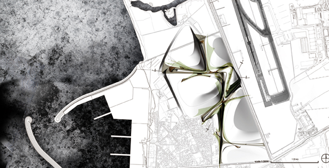
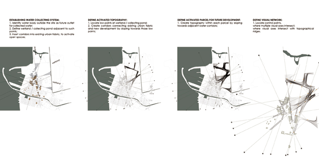
Conceptual Site Plan: showing built topography, landscape layout of water collecting corridors and divided parcels for future urbanization.
Download Hi-Res ImageImage: Mi Yang
Image 1 of 15
 Close Me!
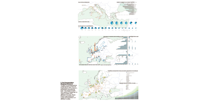
Port Transportation Mapping Research: to gain a comprehensive understanding of the full implications of Fiumicino’s proposed commercial port, the projects starts with series of mappings on various scales and different focuses. These three maps examine cargo transportation on different scales.
Download Hi-Res ImageImage: Mi Yang
Image 2 of 15
 Close Me!
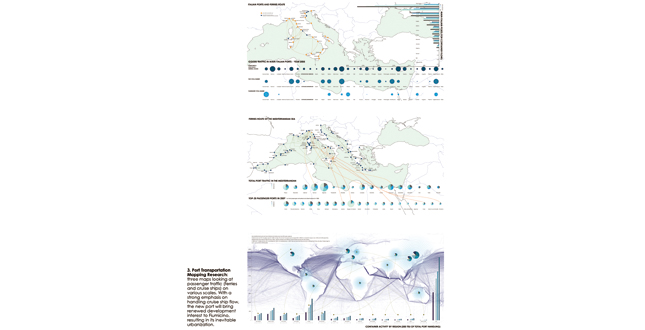
Port Transportation Mapping Research: three maps looking at passenger traffic (ferries and cruise ships) on various scales. With a strong emphasis on handling cruise ship flow, the new port will bring renewed development interest to Fiumicino, resulting in its inevitable urbanization.
Download Hi-Res ImageImage: Mi Yang
Image 3 of 15
 Close Me!
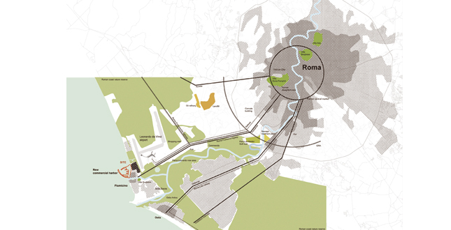
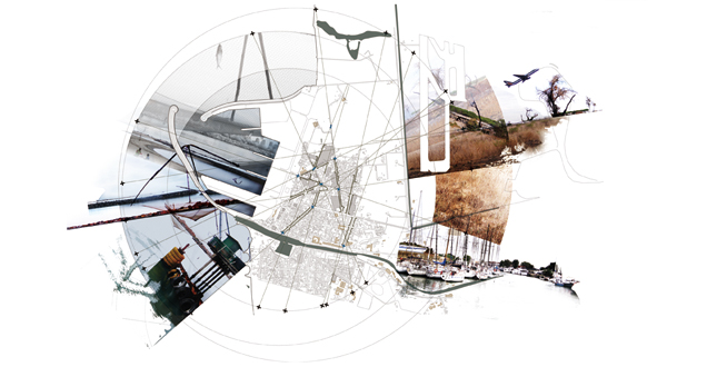
Site Context: the site located north of the historic center of Fiumicino, and borders north with a wetland zone of high historical and environmental value, east with the International Airport Leonardo da Vinci and west with the Mediterranean Sea.
Download Hi-Res ImageImage: Mi Yang
Image 4 of 15
 Close Me!
Design Concept — Topography Generation: Responding to site’s incompatibility with development, (sinking ground, flood risks), the design proposes to build a topography-based "landscape infrastructure," functioning as emergency flood container and daily rainwater collecting corridor, determined by water flow analysis.
Download Hi-Res ImageImage: Mi Yang
Image 5 of 15
 Close Me!
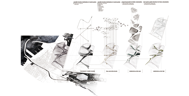
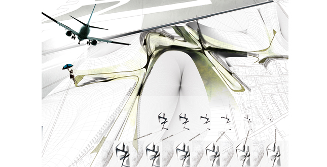
Design Concept — Flexible Urbanism: A visual control system by defining series of visual anchor pints on the topography, could take a different function and provide different experiences synchronized with urbanization process, demonstrating flexibility without dictating exact urban conditions.
Download Hi-Res ImageImage: Mi Yang
Image 6 of 15
 Close Me!
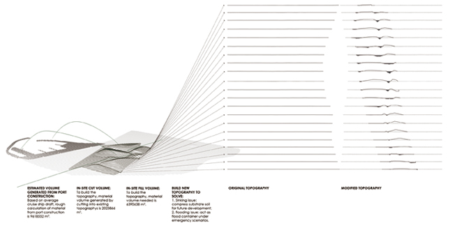
Construction Cut and Fill Calculation: Through series of section modifications, the topography is constructed from materials generated from port construction and in-site cut.
Download Hi-Res ImageImage: Mi Yang
Image 7 of 15
 Close Me!
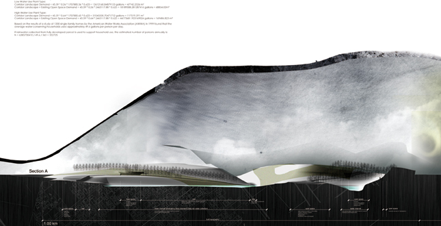
Section A and B Rainwater Collection Calculation: Section showing topography, spatial composition and water level. Rainwater volume under fully development scenarios is estimated, enough to support the corridor’s landscape.
Download Hi-Res ImageImage: Mi Yang
Image 8 of 15
 Close Me!
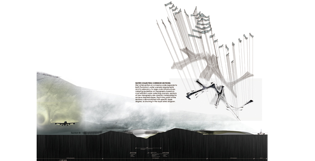
Section B and Slope Analysis: Section showing topography, spatial composition and interrelationship with airport. Slope gradients of the topography are modified following water flow requirements.
Download Hi-Res ImageImage: Mi Yang
Image 9 of 15
 Close Me!
Design Hierarchy: Overlaid with layers of water flows, open spaces, vegetation, the constructed topography enables multiple possibilities, including functioning as a linear park on daily basis and inviting future development.
Download Hi-Res ImageImage: Mi Yang
Image 10 of 15
 Close Me!
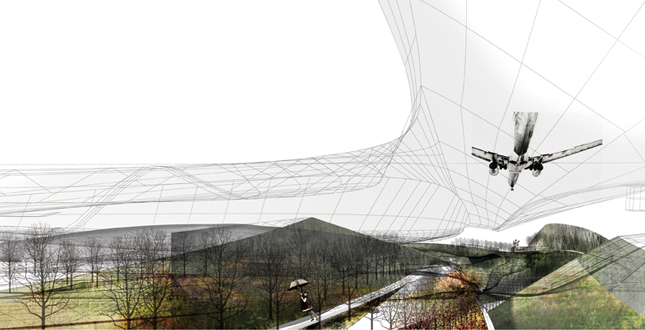
Perspective: Water collecting corridor as linear park
Download Hi-Res ImageImage: Mi Yang
Image 11 of 15
 Close Me!
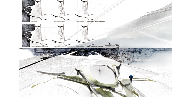
Mechanisms — Two Scenarios: The water collecting corridor could respond to two different water scenarios, emergency flood scenario and daily rainwater scenario, by identifying different inlets and outlets.
Download Hi-Res ImageImage: Mi Yang
Image 12 of 15
 Close Me!
Water Level Scenarios: By accommodating changing water volumes, the water collecting corridor offers rich gradients of interactions between water and topography.
Download Hi-Res ImageImage: Mi Yang
Image 13 of 15
 Close Me!
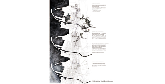
Visual Axis System Definition: Through reading existing urban structure and identifying adjacent infrastructures as spatial experience anchor points, visual axis system could be established, guiding subsequent space composition.
Download Hi-Res ImageImage: Mi Yang
Image 14 of 15
Project Statement
With the advent of a new commercial port, Fiumicino, a small town near Rome International Airport, would embrace its inevitable, but dynamic urbanization. Recognizing the structural force of landscape, the project responds to site's predicament between infrastructure construction, incompatibility with development and emerging urbanism, by proposing a territorial scale landscape framework to steer foregoing issues towards synergy to construct an environmental scaffold, celebrating and interacting with gradual unfolding of unpredictable transformation, synchronized with genius loci.
Project Narrative
—2011 Student Awards Jury
Background and Context
The city of Rome has planned the development of a new commercial port in the vicinity of Fiumicino, close to the International Airport Leonardo da Vinci, the main Mediterranean hub. The realization of such an infrastructure will cause a substantial reconfiguration of Roman coastal landscape, from which fundamental changes in the dynamics of surrounding territory will ensue. For Rome, the new port offers the opportunity to re-capture the historical gates of the city via the sea, whilst for the urban area of Fiumicino, the implementation of an infrastructure of such dimensions implies significant transformation on the loci mainly through the new crossing flows in consistent conversation with pre-existing urban fabric. The site locates north of the historic center of Fiumicino, (with a population of 70,000 people), and borders north with a wetland zone of high historical and environmental value (Coccia di Morto), east with the International Airport Leonardo da Vinci and west with the Mediterranean Sea. This is a territory of rich history but of relatively new formation. It was part of the sea area adjacent to the antique city of Portus, one of the major Mediterranean ports at the time of ancient Rome where ships entered and exited the port of Claudio (A.D. 42-62) and Traiano (A.D. 102-112). In 1950s, the construction of the International Airport drastically changed this area. The vicinity of such infrastructure initially resulted in total abandonment of agricultural land, which appears today as wasteland. Subsequently the increase in air traffic and the resulting demand for space to build service infrastructure has generated renewed real estate development interest. Moreover, the completion of a new port will result in this area's inevitable urbanization, which is outlined by the Master Plan of the Town of Fiumicino.
Challenge, Opportunity and Objective
Fiumicino is anticipating its unavoidable intense urbanization surge brought about by the port proposal. Despite of all the great potentials Fiumicino possesses, risks and problems exist in terms of accommodating incoming development. The ground is sinking, as exceptionally high underground water level results in unstable substrate soil. Furthermore, nearly 80% of the town is exposed to flood risks, rendering the site almost impossible for any future development. Even with such a strong incentive, the urbanization process is more likely to be a dynamic and flexible one, rather than precisely predicted, whose unpredictability is reinforced by port construction plan's vague definition about phasing and adjacent areas. Could there be a way to convert site's innate incompatibility with massive development, even steer towards synergy to encourage and generate a different kind of urbanism? Furthermore, what is the right attitude towards the two gigantic infrastructure neighbors? How to engage in an equal and productive conversation without being engulfed? What about Fiumicino? Does urbanization imply a necessary end, turning into some obscure suburb without identity, especially like those near vast transportation infrastructures, embodied as a patchwork of motels, parking lots and low-quality residential zone? How can Fiumicino obtain its identity through all these changes? The project strives to answer the foregoing questions and brings them into synergy, by recognizing the structural force of landscape in the transformation process that manages to construct an environmental network on a territorial scale in which every intervention can be placed as a part of a unique identity system, so that the flexible scaffold can have the strength to sustain the transformation and synchronize it with the natural characteristics of the site. The site's strategic location offers opportunity to construct a flexible system capable of interacting with the unpredictability within landscape framework.
Solution / Design
The project consists of two directions functioning on corresponding scales. On territorial scale, it proposes to construct a topography-based "landscape infrastructure" to respond to multiple challenges and essentially prepare the ground for future development, encouraging gradual unfolding of different urban scenarios. On human scale, it draws inspirations from historical precedents of Roman city planning and Renaissance Italian villas, bringing a visual control system to the design as a new way to guarantee urban life quality within unpredictable and dynamic urban conditions. The overarching concept of the design is to build topography as emergency flood container and daily rainwater collecting corridor, dividing future urban parcels, compressing substrate soil for development, functioning as ecological corridor at regional scale. The overlaying of visual control network onto the topography determines anchor points, which are connected via paths, take on different functions and become nodes in urban life. By bridging the gaps between two different scales, the proposal offers solid ground inviting different urbanization to happen while maintaining considerations for human-scale urban experience.
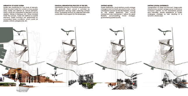
On Territorial scale, materials from port construction and in-site cut are utilized to build the topography, which are shaped following water flow logic based on two scenarios, emergency flood scenario and daily rainwater scenario. Generation of topography is guided by: 1. identifying water body outside the site as future outlet; 2. defining wetland or collecting pond adjacent to such outlets, as topographical low points; 3. inserting collecting corridors into existing urban fabric, to activate open spaces; 4. creating corridors connecting existing urban fabric and new development by sloping towards low points. Thus the corridors naturally demarcate parcels, inside which ground is built up and substrate soil is compressed, eventually becoming suitable for development. This landscape infrastructure accommodates flexible utilization patterns, in terms of both different scenarios and varied water volumes, generating rich gradients of interaction between fixed ground and dynamic natural forces. On human scale, visual control axes are determined based on analyzing existing urban structure by reading its visual implications, generated by following main streets, connecting open spaces and town center. Viewing infrastructure as potential spatial experience anchor point provides new possibility to colonize the site following the same logic but with renewed elements. By combining these two sets of axes, control lines of visual connection for future development could be established. Visual anchor points' locations are further defined where either multiple visual axes intersect with each other, or visual axes intersect with topographical ridges. Those visual anchor points are materialized as open spaces within the topography. Connected by pedestrian and bicycle path, this line and node system forms the foundation of a linear park, transforming this function-based topography into urban amenity, accommodating multiple needs. Function of each open space is determined by its relative location regarding future development and topography. For instance, some may serve as entrances from future community to the park; others may serve as overlook terraces, while their functions and spatial experiences are highly flexible, open to changing situations in the future. Given the fact that the site and adjacent areas have abundant archaeological relics, it is proposed to incorporate outdoor exhibition into the open space experience, infusing a unique community identity. The design's features, including its orientation and response to big-scale infrastructures, openness to varying water levels and flood, provide the possibility to juxtapose ancient relics with infrastructure, flood and everyday life. This kind of renewed juxtaposition serves as starting point of the design, as well as the foundation of community's identity.
Additional Project Credits
Harvard University Graduate School of Design
Department of Culture of the Italian Government
Special thanks to Arch. Daniela Sandroni, Arch. Piero Aebischer, Arch. Stefania Cancellieri.
University of Rome, Architecture School Valle Giulia
Special thanks to Professor Pier Paolo Balbo, Professor Francesco Rossi, Professor Lucio Carbonara, Professor Pier Ostilio Rossi, Professor Carlo Valorani, Professor Stefan Tischer.