


Honor Award
Baltimore Water Works: Adaptive Hydrology in the Jones Falls Corridor
Maggie Hansen, Student Associate ASLA and Suzanne Mathew, Student Associate ASLA, Graduate, University of Virginia
Faculty Advisor: Jorg Sieweke
 Close Me!
Baltimore Water Works: Adaptive Hydrology in the Jones Falls Corridor
Download Hi-Res ImageImage 1 of 13
 Close Me!
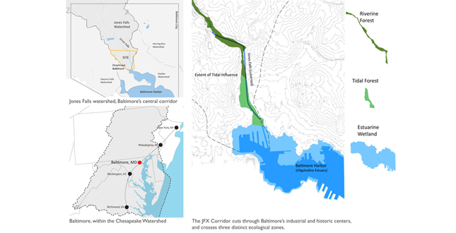
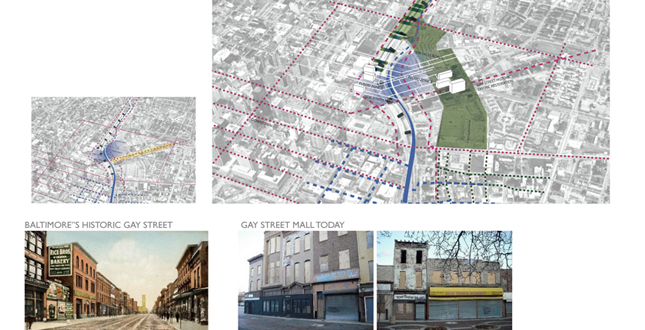
Baltimore's Water Network — The JFX Corridor cuts through Baltimore's industrial and historic centers, and crosses three distinct ecological zones.
Download Hi-Res ImageImage 2 of 13
 Close Me!
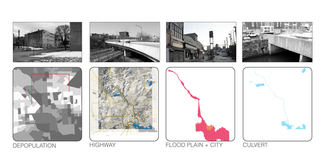
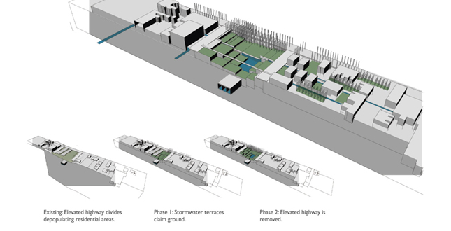
Baltimore's Failing Central Infrastructure — The Jones Falls corridor cuts through the heart of Baltimore city. The culvert river contributes to larger pollution and sedimentation problems in the regional watershed. The Jones Falls Expressway acts as a division between neighborhoods.
Download Hi-Res ImageImage 3 of 13
 Close Me!
Restructuring the Central Groundwork.
Download Hi-Res ImageImage 4 of 13
 Close Me!
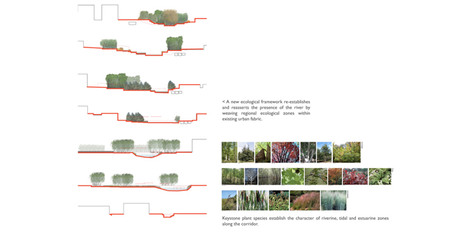
Establishing a Hydrological Matrix through Terraced Infrastructure.
Download Hi-Res ImageImage 5 of 13
 Close Me!
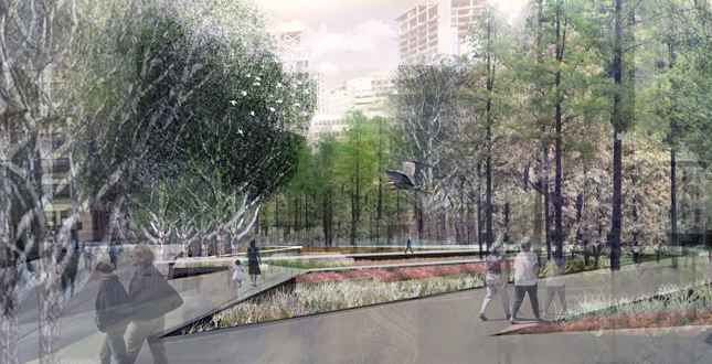
New Public Ground — the wetland terraces create a new territory both for wildlife and for residents of Baltimore.
Download Hi-Res ImageImage 6 of 13
 Close Me!
An adaptive model for abandoned neighborhoods
Download Hi-Res ImageImage 7 of 13
 Close Me!
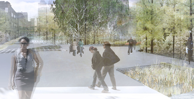
From Roof to River — Over time, the wetland infrastructure extends into surrounding neighborhoods and connects residents to regional ecology. This adaptive framework allows Baltimore to establish a mechanism to remediate the health of both the river and the urban fabric.
Download Hi-Res ImageImage 8 of 13
 Close Me!
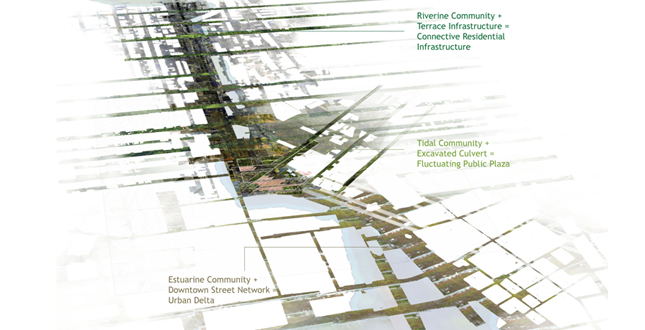
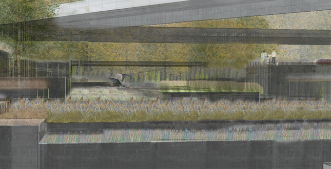
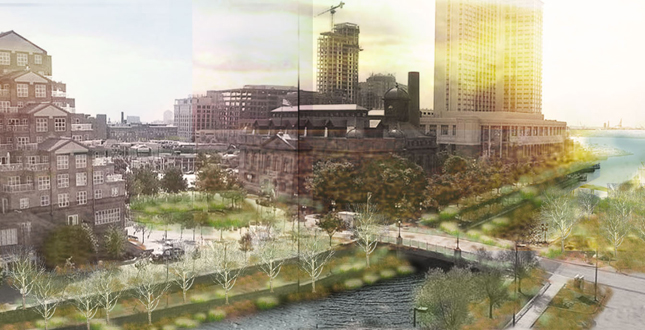
Embedding Tidal Fluctuations in Layered Public Ground — The Tidal Plaza establishes a public space where the temporal flux of the bay and the river are visible. Wetland terraces interwoven with public walkways connect between Baltimore’s Historic Mall, downtown, and harbor district.
Download Hi-Res ImageImage 9 of 13
 Close Me!
The culvert is opened to reveal change at the extent of tidal influence and to thread public space through an active wetland. This tidal plaza serves as a seasonal marketplace.
Download Hi-Res ImageImage 10 of 13
 Close Me!
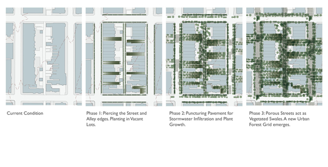
New Ecological Groundwork Reintegrates Historic Oldtown District
Download Hi-Res ImageImage 11 of 13
 Close Me!
The network brings both walkable, shaded public spaces and clean water infrastructure to every block along the corridor. Real estate value is re-established by environmental equity, and development is restructured within an ecological and hydrological framework.
Download Hi-Res ImageImage 12 of 13
 Close Me!
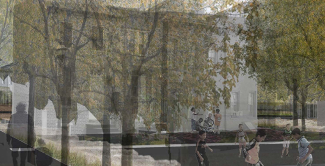
Inhabitants' daily lives are infused with the specific seasonal and daily fluctuations of Baltimore’s unique ecology along the Chesapeake Bay. These natural shifts in water temperature, scent, and color celebrate specific natural context of the city.
Download Hi-Res ImageImage 13 of 13
Project Statement
Baltimore Water Works utilizes the unique resilience of river delta ecosystems to create a hybridized landscape infrastructure that unites ecological health with urban vitality. This adaptive framework, designed for Baltimore's Jones Falls River corridor, employs the functional river ecology to reinvigorate abandoned and economically depressed areas within the city's core, and to create a model for stability that allows urban density to both contract and expand.
Project Narrative
—2011 Student Awards Jury
Baltimore Water Works creates a generative landscape infrastructure to re-establish a functional and ecological identity for the Jones Falls River corridor. The new stormwater armature creates a cross grain that reconnects neighborhoods once divided by the JFX highway, while establishing an ecological framework that will regenerate abandoned areas adjacent to the corridor.
The city of Baltimore has a rich industrial history that is rooted in its position as a city founded on a river delta. Jones Falls is one of three rivers within the city and cuts through the heart of Baltimore's residential and industrial neighborhoods. Once a generative asset, Jones Falls is now suppressed. The river has been culverted, contributing to urgent concerns about sedimentation and pollution in Baltimore Bay and the regional Chesapeake watershed. The Jones Falls Expressway, a highway constructed against the city resident's wishes, now occupies the river valley. The highway increases perceptions of the corridor as a division, and acts as a visual and sometimes, physical barrier between neighborhoods.
As both the highway and the culvert approach the end of their life expectancies, there is an opportunity to address the corridor with a new approach to infrastructure. This project establishes an adaptive, landscape framework to address the pressing stormwater concerns of the Jones Falls watershed, while creating new spaces of public occupation and pedestrian traffic, and establishing a specific series of regional identities based in topography and hydrology. The specific position of Baltimore within the northern Chesapeake Bay watershed places it within an oligohaline (low salinity) estuary. Tidal waters push into the Jones Falls river corridor and create zones of fluctuation that can be utilized to support specific, regional ecological communities, and to create a hydrological framework for the corridor. This project allows for the phased removal of the failing JFX highway and creates a dendritic landscape armature that articulates the riverine, tidal and estuarine zones.
Baltimore has been experiencing a prolonged period of depopulation and suburban flight, and as a result large areas of the central city have been abandoned and have fallen into disrepair. A number of these areas are immediately adjacent to the JFX corridor. Additionally, a number of buildings along the corridor are located within the 100-year flood plain and experience frequent flooding from stormwater surges. This project creates a generative landscape infrastructure that stitches across the corridor through a series of shifting wetland terraces. These terraces create an armature that extends from the river corridor into neighboring areas, providing a new logic for stormwater management, and a regenerative network for neglected areas of the city.
As this infrastructure grows, it extends into surrounding neighborhoods, ecological parcels are established in abandoned lots. These parcels, along with a pedestrian stormwater network, connect underutilized areas to the river corridor, re-establish value and interest, and allow for strategic redevelopment over time. This model for an ecological and urban mosaic questions traditional models for urban renewal that prioritize density, and instead proposes a successional model that allows Baltimore to thrive in a state of stabilized ecological and urban flux.
The culvert, which predates the JFX by seventy years, has long subverted the river ecology and fails to accommodate large storm surges. It acts as a conduit for polluted waters coming from agricultural and suburban areas in the upper watershed directly into the Chesapeake Bay. The new armature of wetland terraces within the Jones Falls Corridor will recapture base flows from the culvert and begin to filter harmful pollutants from the water before it reaches the bay. The culvert will remain in place as a redundant system for large storm events. As the culvert reaches the bay, it will be opened into a bioretention plaza. This wetland plaza will act as a joint between overflows from the stormwater corridor and fluctuations from the tide, creating a place within the public realm where the temporal flux of the bay is visible, and creates a thriving wetland ecology. This site also acts as a node between Baltimore's downtown and harbor districts, and its historic Oldtown district and downtown mall. Like much of Baltimore, the historic mall has been undervalued and abandoned. The new tidal plaza will support community activities such as a seasonal farmer's market (that currently operates on this site underneath the elevated highway) and act as a regenerative node for the Oldtown district.
Additional Project Credits