Project Statement:
Climate stabilization will require 80% reductions in
greenhouse gas emissions by 2050. This project researched
how to retrofit existing residential neighbourhoods
to reduce emissions by 80% from household energy, transportation
and food, while allowing for population increases. Working
across scales and using site-specific solutions led
to adaptive, localized energy systems, an innovative
urban agriculture system, and a transportation system
retrofitted for pedestrian/transit. The project demonstrates
the critical contribution of Landscape Architecture
to climate change mitigation.
History and Site Context: Time
for Change The
Research Problem
Climate change threatens the future global economy (Stern
Review 2006), the future of global biodiversity as modelling
shows up to 50% species extinctions (Thomas et al 2004),
and future social stability as mass population migrations
respond to water shortages, droughts and flooding (Stern
Review 2006, Raskin 2005). International consensus holds
that 80% greenhouse gas reductions are necessary by
2050 to stabilize climate. How can these reductions
be achieved within existing low-density residential
neighbourhoods for household energy use, food and transportation
while allowing for population increases? No North American
community has answered this yet.
The research focused on finding
solutions that can be spatialized and applied
to a specific neighbourhood, and developing
a process for site-adaptive climate change
mitigation in local neighbourhoods. Working within a
Low-Carbon future scenario, the project assumed intensive,
immediate and ongoing climate change mitigation out
to 2050, with resultant fewer climate change impacts
such as water shortages than under a Business-as-Usual
scenario.
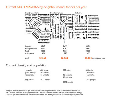
The study area is located within the Still
Creek watershed in Burnaby, British Columbia. As a suburb
of Vancouver, the existing low-density residential neighbourhoods
are car-serviced and rely on 100% imports of food and
energy (natural gas and electricity). Steep slopes separate
the neighbourhoods from an elevated Light Rapid Transit
system (Skytrain). The climate is a mild maritime one,
with wet winters and cool summers.
Relationships Investigated and
Method of Inquiry
The project unpacked and re-packed the interlinked systems
of energy, food and transportation. Mitigation solutions
were found through precedent studies, a literature review,
and interviews with technical experts. The solutions
were spatialized in order to consider applicability.
For example, stormwater catchment areas were calculated
to generate potential rates of flow in stormdrains which,
along with potential drop (head), allowed for potential
micro-hydro calculations. The findings showed that micro-hydro
is not a feasible option for this location. Similar
research also removed sewage heat recovery and CHP (biomass
fuelled Combined Heat and Power) from the list of potential
actions; the actions that remained are thus both feasible
and site-adapted. Research on renewable and alternative
energy sources, particularly for house heating and hot
water, but also for vehicles, on urban agriculture and
on best practices for pedestrian/ bicycle/transit oriented
development proved essential to the project.
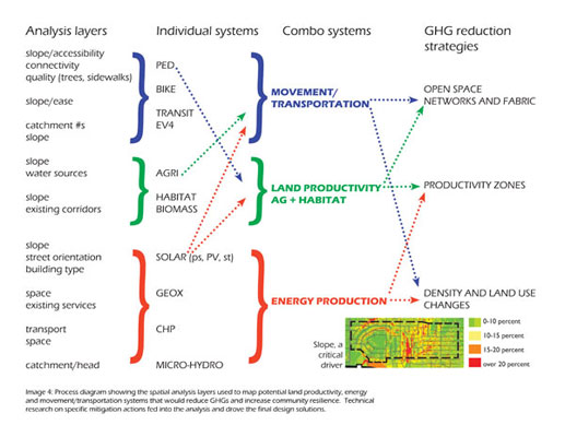
The analysis used GIS, CAD, photography,
and hand mapping to identify opportunities and constraints.
Technical requirements helped to determine the analysis
layers, which in turn drove systems design. The process
diagram (Image 4) delineates the linkages between the
analysis layers, individual systems, and combined systems
that affect both urban form and GHG reductions strategies.
For example, transportation and energy production together
drive density and land use changes. Slope is a significant
driver and was assessed in multiple ways including GIS
analysis for the watershed and hand-drawn street-scale
analysis for exiting dead-ends and assessing agricultural
potential. The process, although shown as linear, required
a cyclical, multi-iterative process to arrive at the
end product, which becomes a starting point for further
work, particularly visualizations.
Research Results
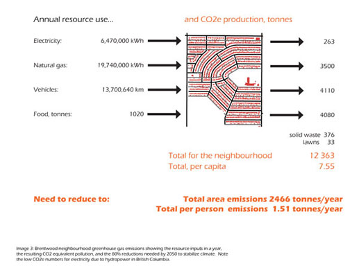
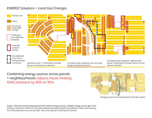
The ENERGY SOLUTION combines actions that together reduce
natural gas usage by over 85% while maintaining the
electrical load at current levels and accommodating
a population increase of 60% by 2050. The combination
of strategies includes:
- Conservation and efficiencies,
including solar thermal: saves 25% on household
electrical, 30% on natural gas usage for house heating,
and up to 75% of natural gas for hot water.
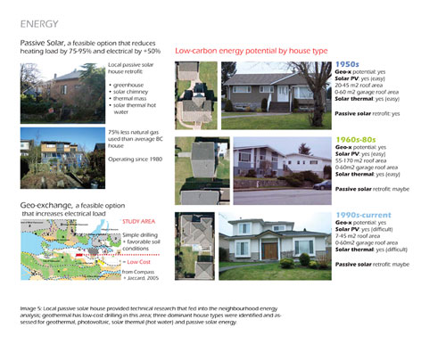
- Geothermal: 7.5m x 7.5m for
vertical drilling per house; is possible
in the rear yards or lanes; costs less than $20,000
per house; decreases the natural gas to 0; it adds
electrical load.
- Photovoltaics: the local energy
potential is about 1000 W/m2/year; in the
Brentwood Neighbourhood, roof PV would allow for an
increased electrical demand of 25%, at a cost of $15,000
per house.
- Passive solar: A
functioning passive solar retrofit home in Vancouver,
operating since 1980, uses 25% of the natural gas
of a regular house. New PassivHaus buildings developed
in Europe use less than 15% the energy of older buildings.
For the Brentwood neighbourhood, a combined approach
could reduce household energy GHG emissions from 3500
tonnes per year to 515, with per capita going from
2 to 0.22 tonnes per year.
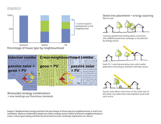
Landscape structure reveals the local
energy production, with careful street tree placement
required to maintain solar access. The energy solution
enhances local resilience -- the neighbourhood remains
linked to the grid and requires some inputs (biomass
for heating passive houses), but uses heat from solar
and geothermal sources, and produces 20% of its electricity.
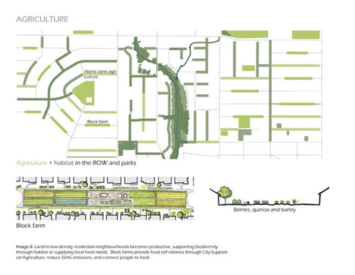
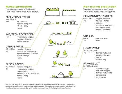
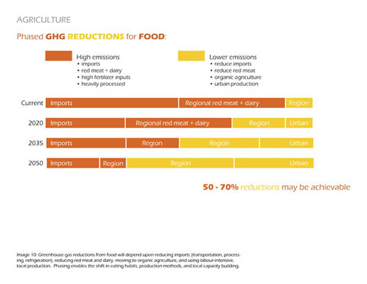
For the AGRICULTURE SOLUTION,
the landscape becomes productive rather than decorative.
While quantifiable data on greenhouse gas emissions
linked to specific foods remains scarce, local organic
production can significantly reduce emissions, supplying
potentially up to 75% of local food needs by 2050. Community
gardens would be the first step in capacity building,
followed by market urban production including farms
in parks, and, lastly market gardens replacing some
roads. Non-market production includes fruit street tree
plantings, berry bushes, home grown gardens, and household
chickens.
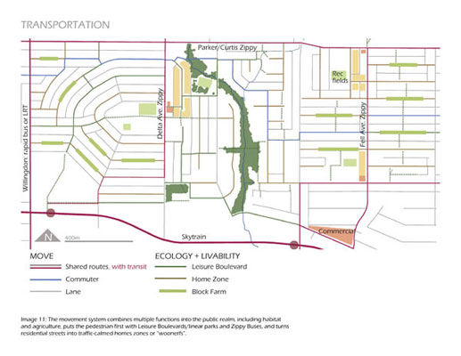
The ROW provides the largest public land
area (over 70% of the public land) in the neighbourhoods,
and it becomes the location for multiple functions including
improved pedestrian amenities, habitat and agriculture,
and consideration of local energy production. New urban
food systems work across scales, and have impacts on
transportation. As well, plant associations and habitat
types were used to develop guidelines for urban habitat
plantings that meet the needs both of a highly functioning
ecological matrix, and the concerns of citizens for
orderly and beautiful vernacular landscape expressions.
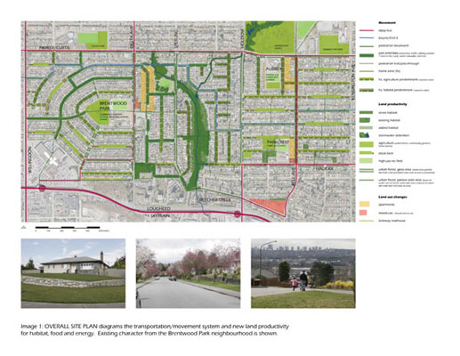
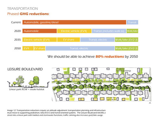
The TRANSPORTATION system,
more than any other, requires an attitude adjustment,
particularly on the part of planners and politicians.
A phased mode shift, with the majority of private vehicle
use moving to electric public transit yields excellent
emissions reductions. Pedestrian pass-throughs in the
Fell Avenue neighbourhood enhance connectivity where
each block is 400 meters long. Adding pass-throughs
on several of the Beecher Creek neighbourhood dead-ends
allows residents to walk to either the Delta Zippy or
the Parker/Curtis Zippy Bus.The Zippy Buses are the
only solution that have yet to be properly designed:
imagine a cross between a community shuttle bus, an
electric vehicle, and an i-pod: sexy, convenient public
transit.
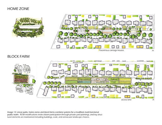
COMBINED SYSTEMS: Home zones
build on the Dutch woonerf concept of inviting cars
into residents’ social and play spaces. Swales,
play areas, gathering areas, and planters remove asphalt
and visibly demonstrate the shift from private vehicles
toward multiple uses in the ROW.
Block farms maintain pedestrian pathways
while removing the road altogether and replacing it
with agricultural crops. Vehicular access is maintained
through the back lanes.
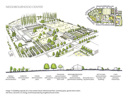
All the actions and systems come together
with place-making to produce a neighbourhood
center for Brentwood Park. The centre builds
local mitigation capacity through demonstration agricultural
and habitat plantings and passive energy building technologies.
Community services include a seniors centre and market
garden coordination. A plaza and meadow provide outdoor
space for celebrations and functions; a sports field
enables local recreation. Quieter activities to the
west of the school include a community garden, a plant
greenhouse and nursery, an apiary, a ha-ha enclosure
for the sheep who will maintain the park meadows, and
a children’s garden.
Significance of Results
This project is the first holistic neighbourhood study
of how to achieve a low-carbon future. With the site
system plan, each block can be located within site adaped
and specific systems. Climate change mitigation has
been spatialized and localized. Each block has multiple-functions
and a landscape structure that reflects its agricultural
potential, its energy source (with careful tree placement
for PV and passive solar), and the movement system.
Together, they form a holistic set of systems that should
be able reduce GHG emissions by over 80%.
The landscape of our cities has a very
significant role to play in climate change mitigation.
Density increases need to be linked not only to transportation
and services needs, but also to local energy production
sites. Energy sourcing for heating can be solved with
technical changes that can be embedded into neighbourhoods
without large behavioural changes. Agriculture/food
will require larger behavioural/visual changes. Transportation
will be the most difficult to directly control through
design solutions: enhancing the pedestrian realm, and
moving resources away from cars provide the most direct
changes, which, according to Gehl, can result in significant
quantitative increases in pedestrian usage (2008).
Finally, the main finding was that there
is no need for extraordinary solutions. All of the solutions
are quite simple, using current and existing technologies,
although sometimes in new ways. It is the combination
of ordinary actions that can create extraordinary results,
a series of small moves that can significantly alter
the landscape of our cities and our capacity to both
mitigate climate change and increase local resilience.
The solutions are both incredibly simple, and yet require
a 180 degree change of thinking – a lack of vision
remains our biggest barrier.
Applicability to Landscape Architecture
Practice
Landscape architects have a key role to play in moving
our society towards climate stabilization, working and
leading multi-disciplinary teams. The fabric of our
cities and regions consists of open space and landscape,
and we are best placed to understand the spatial requirements
of changes to housing energy, transportation systems,
and urban agriculture. However, we need a strong research
and knowledge base from which to act. This project initiates
research into actions that can be used by local communities
to mitigate their climate change impacts. It provides
technical data, an analysis and design process, and
preliminary proposals about systems solutions. Finally,
landscape architects can provide the visualizations,
a critical next step, which will enhance community understanding
of the difficult choices that lie ahead, and encourage
responsible community decision-making in the face of
an unpredictable future.
|