|
 |
|
ANALYSIS & PLANNING AWARD OF HONOR
Bear River Greenway Master Plan/Bear Rive Ecological
Corridor Restoration
Lori Porreca, Student ASLA, Sara Sevy, Student ASLA, Kris Kvarfordt, Student
ASLA, Susan Buffler, Student ASLA, Chad Kennedy, Student ASLA, and Laura McCoy,
Student ASLA
Utah
State University
Advisors: Peter Kumble, ASLA, and Craig Johnson
|
|
|
Narrative Summary:
- The project’s goals and objectives;
- What kinds of environmental and social data were collected
and analyzed;
- Methods of analysis;
- How options were considered;
- How interested parties would be involved with the project;
- How design was used in the process;
- How the project would be implemented; and
- How the project would be administered and/or monitored
Goals and Objectives
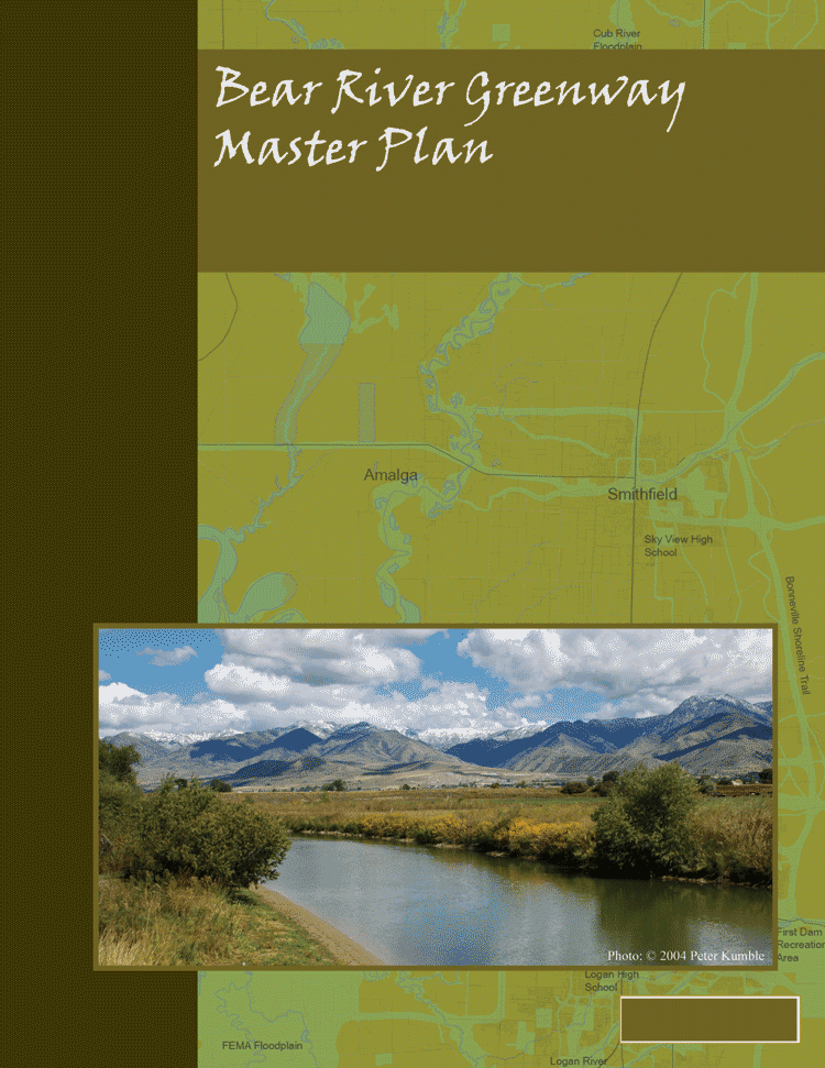
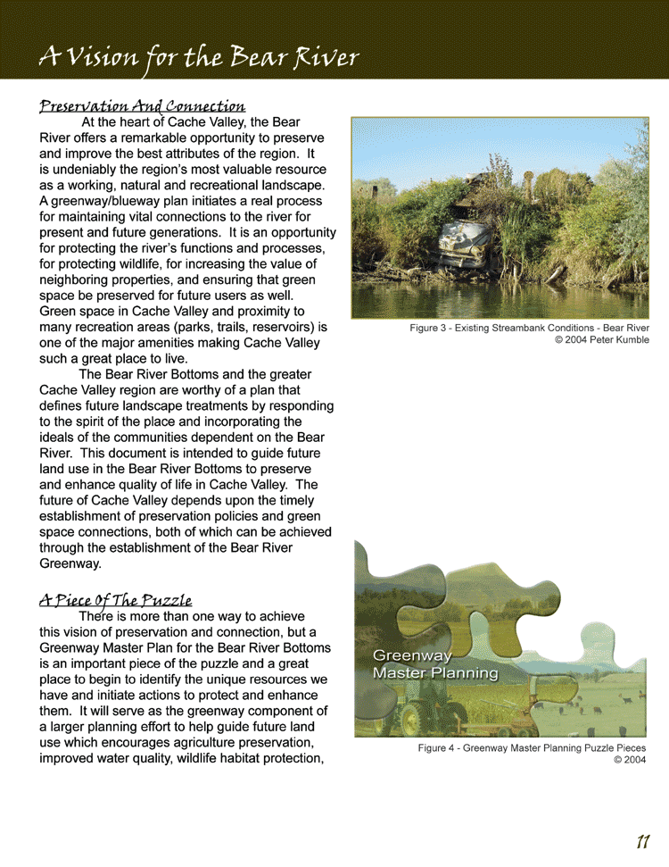
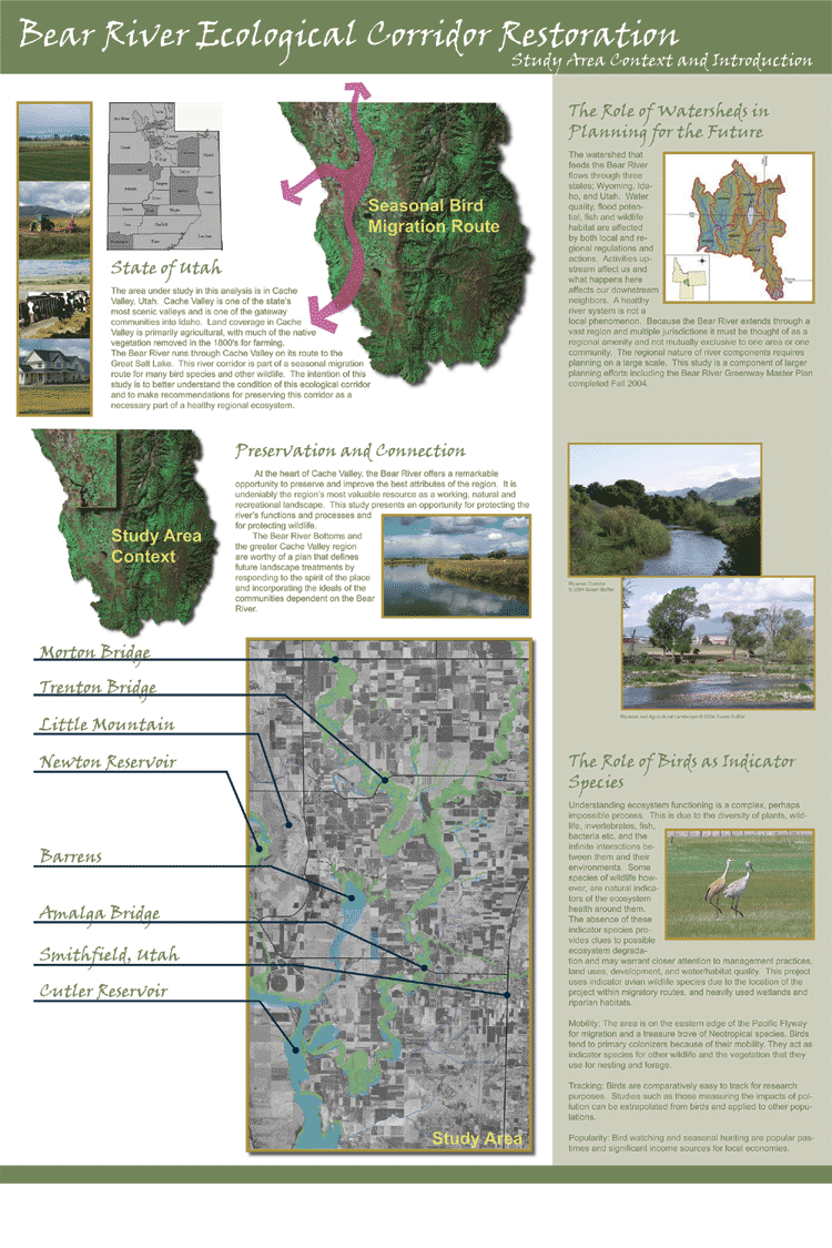
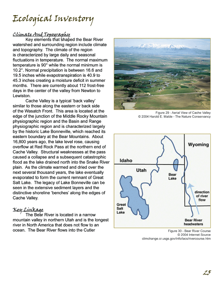
At the heart of Cache Valley in Utah, the Bear River offers a remarkable
opportunity to preserve and improve the best attributes of the
region. It is undeniably the region’s most valuable resource as a
working, natural and recreational landscape. A greenway/blueway
plan initiates a real process for maintaining vital connections
to the river for present and future generations. The plan consists
of two sections. In the first section, the project team developed
a regional greenway plan for the Bear River, composed of recommendations
and implementation strategies the region and five treatment zones;
ecological, rural, urban, county-wide and riverfront. In the second
section, the team addressed landscape-scale wildlife planning issues
within the study site by developing restoration and management
recommendations for a section of the Bear River corridor.
The project team began with the following goals:
- Protect and enhance natural features for wildlife habitat,
water quality and scenic amenity.
- Provide recreation access to the corridor through appropriately
located and developed facilities.
- Identify and secure preservation for lands crucial for habitat
and recreation linkages.
- Promote awareness and preservation of historic, cultural, and
ecological resources along the corridor through education and
interpretation
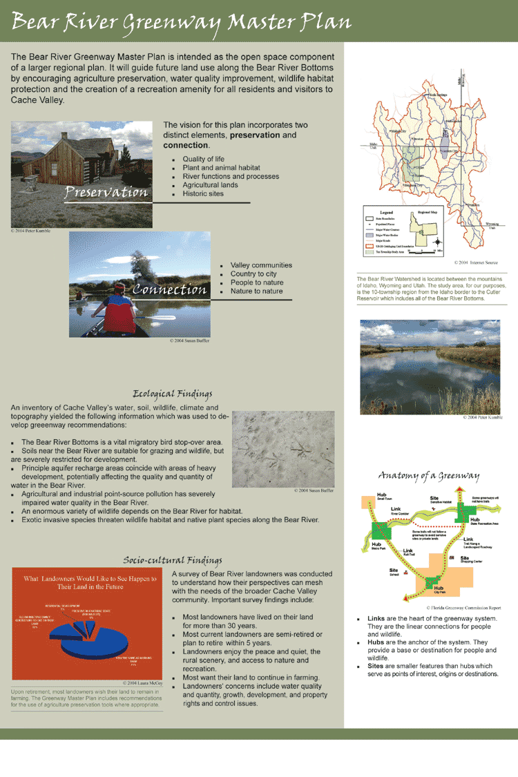
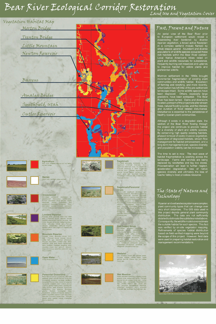
Inventory and Analysis
The inventory and analysis of the study area were approached comprehensively,
identifying resources related to people, places and the environment.
An ecological inventory was conducted to identify relevant natural
system components such as water quality, soil suitability and wildlife
habitat issues. A landowner survey was administered to identify
current land use, ownership patterns and landowner concerns. An
inventory of all existing and possible open space network components
identified possible greenway links, hubs and sites.
Existing GIS data from the Logan City and Cache County were compiled
to identify areas that could be used to construct a framework of
hubs, links and sites. Each element was mapped separately in order
to easily identify and emphasize the importance of connecting these
resources as the population of Cache Valley continues to grow.
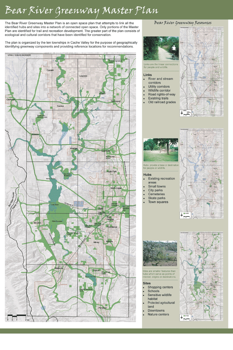
Hubs consist of existing open spaces within
the study area. Community resources such as existing recreation
areas, town squares, city
parks, cemeteries and golf courses have all been mapped as park
of the network of hubs within Cache Valley. Many of these hubs
serve
as critical habitat areas for wildlife and also destinations for
many of the valley’s residents. These spaces are also commonly
viewed as amenities that contribute to the overall quality of
life
and perceived beauty of a region. It is also important to note
that while many of these spaces are public, many of them are
also private,
which further reinforces the cooperation and partnerships that
will be required to make this plan a success.
Sites consist of many open spaces and other destinations throughout
the study area. These areas have been identified two-fold; first
as critical destinations for humans to include recreation, open
space, shopping centers and campuses, and second as critical destinations
for wildlife to include, critical habitat areas, river corridors
and rural open space. Sites add another layer of complexity to the
development of the greenway master plan by adding even more areas
that are a priority for connection as part of the greater framework.
However, the river corridor, identified as a site, provides that
linkage and also establishes the corridor as being critical to the
region for many reasons beyond the conveyance of water.
Perhaps the most critical components to a successful greenway plan
are the linkages between hubs and sites. Connectivity is important
because it allows for animal migration and creates opportunity for
transportation alternatives to the automobile. This study inventoried
all of the corridors that could be included in the greenway system.
Existing trails, select roadways, utility corridors, old rails lines,
canal easements, and stream corridors have all been identified as
potential greenway linkages.
The physical component of the plan is a melding of all of the hubs,
links and sites into a network of connected open space. Only specific
portions of this network are identified for trail and recreational
development. The bulk of the open space network consists of ecological
and cultural corridors that have been identified for conservation.
The Bear River Greenway Master Plan is intended to function as the
open space component of a larger regional plan. It will serve to
guide future land use along the Bear River Bottoms to encourage
agriculture preservation, water quality improvement, wildlife habitat
protection and restoration and the creation of a recreation amenity
that will last long into the future.
Results and Recommendations
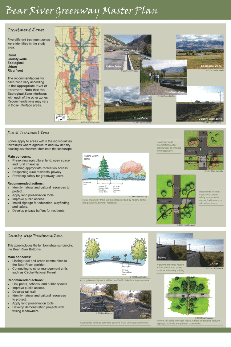
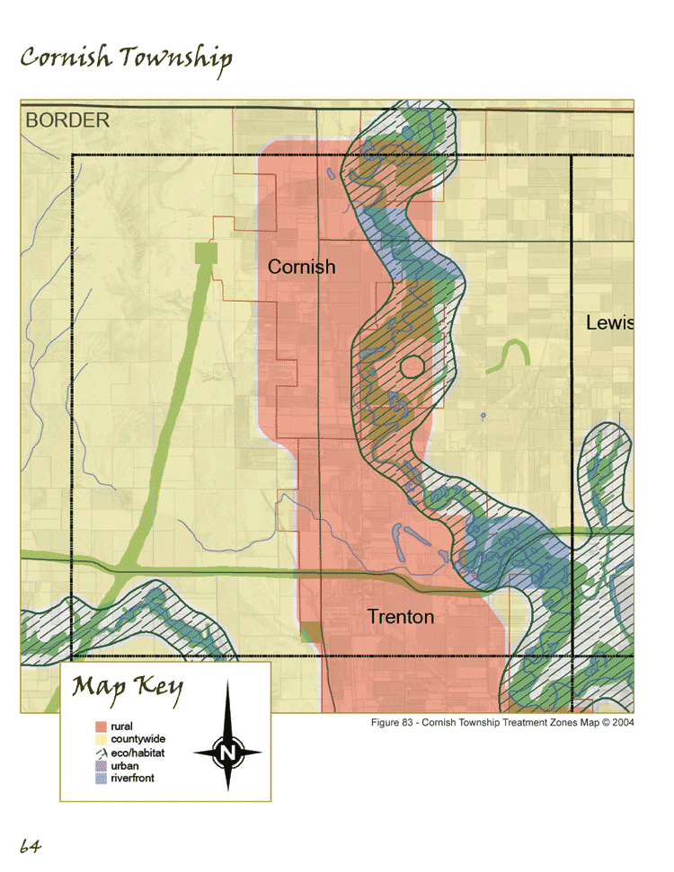
Five different treatment zones were identified in the study area.
The five zones are rural, urban countywide, riverfront and ecological.
The recommendations for each zone vary according to the level of
treatment that is appropriate and feasible.
Rural treatment zones apply to landscapes that are dominated by
larger intact land parcels. Large and small-scale agriculture is
the primary land use, followed by low-density residential development.
Rural treatment zones exist within town boundaries and in unincorporated
county lands. Residents in rural areas may be associated with farmsteads
and have long intergenerational ties and multiple land holdings.
Main concerns include: preservation of agricultural lands, open
space and rural character; maintaining a viable agricultural economy;
appropriate recreation access; resident privacy; and greenway user
safety and education. Recommended actions include: identify natural
and cultural resources to protect; develop privacy buffers for residents;
install signage for education, way-finding and safety; improve public
access; and apply land preservation tools such as agricultural zoning,
right-to-farm laws, conservation plans and education programs. Privacy
buffers and narrows paths characterize greenway access in rural
areas. Designs incorporate safety features where trails or bike
paths intersect with roads or railroad corridors. Intersections
of greenway trails and roads near rural towns offer the opportunity
to develop or enhance local gateway features.
The countywide zone includes unincorporated land in the ten townships
surrounding the Bear River Bottoms. This category is concerned with
linkages such as trails, bikeways and wildlife and recreation connections
to other management units such as the Cache National Forest. Recreation
amenities include bike lanes shared with roadways, local trail linkages
to regional trail systems and utility and rail corridors for wildlife
and recreation and transportation. Main concerns include: linking
rural and urban communities to the Bear River corridor and connecting
to other management units, such as Cache National Forest. Recommended
actions include: linking rural and urban communities to the Bear
River corridor; linking parks, schools, and public spaces through
the green infrastructure; improve and concentrate public access
in order to preserve ecologically sensitive areas; develop a rail-trail
along Union Pacific rail line; identify lands to take action on,
secure and preserve; and develop demonstration projects. In countywide
zones, greenway features are mostly linear connections and travel
ways. Appropriate county roads will be targeted to become shared
roadways. Improved bike lanes will feature five-foot minimum paved
shoulders with safety striping. Abandoned railroad corridors can
become multi-use ADA accessible trails. Where roads and rail-trails
intersect, safety treatments include signage, bollards and painted
crosswalks.
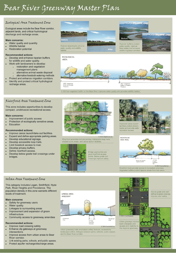
The ecological zone includes the Bear River corridor and adjacent
land as well as critical ecological and hydrological recharge areas
in other parts of the valley. The emphasis is on protection of water
quality and wildlife habitat. Public access is limited to the river
corridor. As much of the vegetation and streambank on the Bear River
corridor is degraded, restoration will be a key component in the
long-term management of this zone. Main concerns include: protection
of water quality; continued availability of water for residents;
protection of wildlife habitat; and restoration of key areas. Recommended
actions include: develop and improve riparian buffers for wildlife
and water quality; work with landowners to develop restoration and
vegetation management plans; develop alternative livestock watering
methods; provide alternatives for animal waste disposal; protect,
develop and improve migration corridors; identify and preserve hydrological
recharge and discharge areas; and apply appropriate planning tools
for land protection. Treatments in ecological zones focus on wildlife,
vegetation and water. Working with landowners, stream restoration
can begin as alternative livestock watering methods are developed.
A 300-foot vegetated buffer strip filters agricultural waste improving
water quality and provides riparian wildlife habitat.
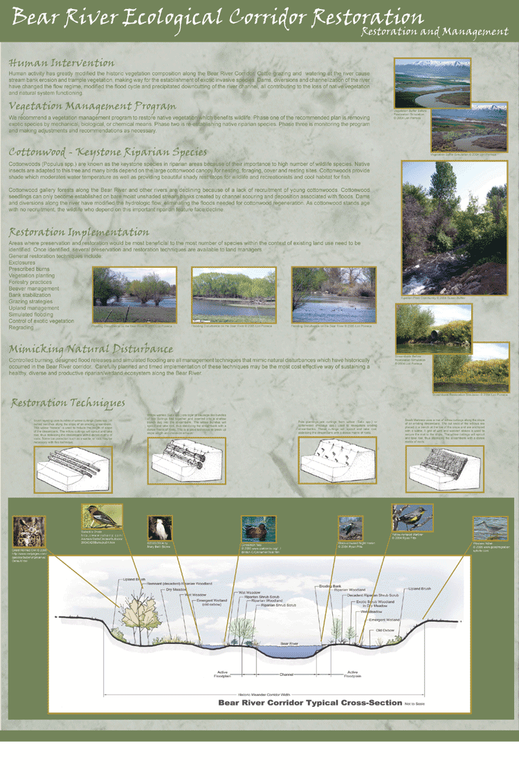
Also within the ecological zone, the team developed more detailed
restoration and management goals and recommendations for a smaller
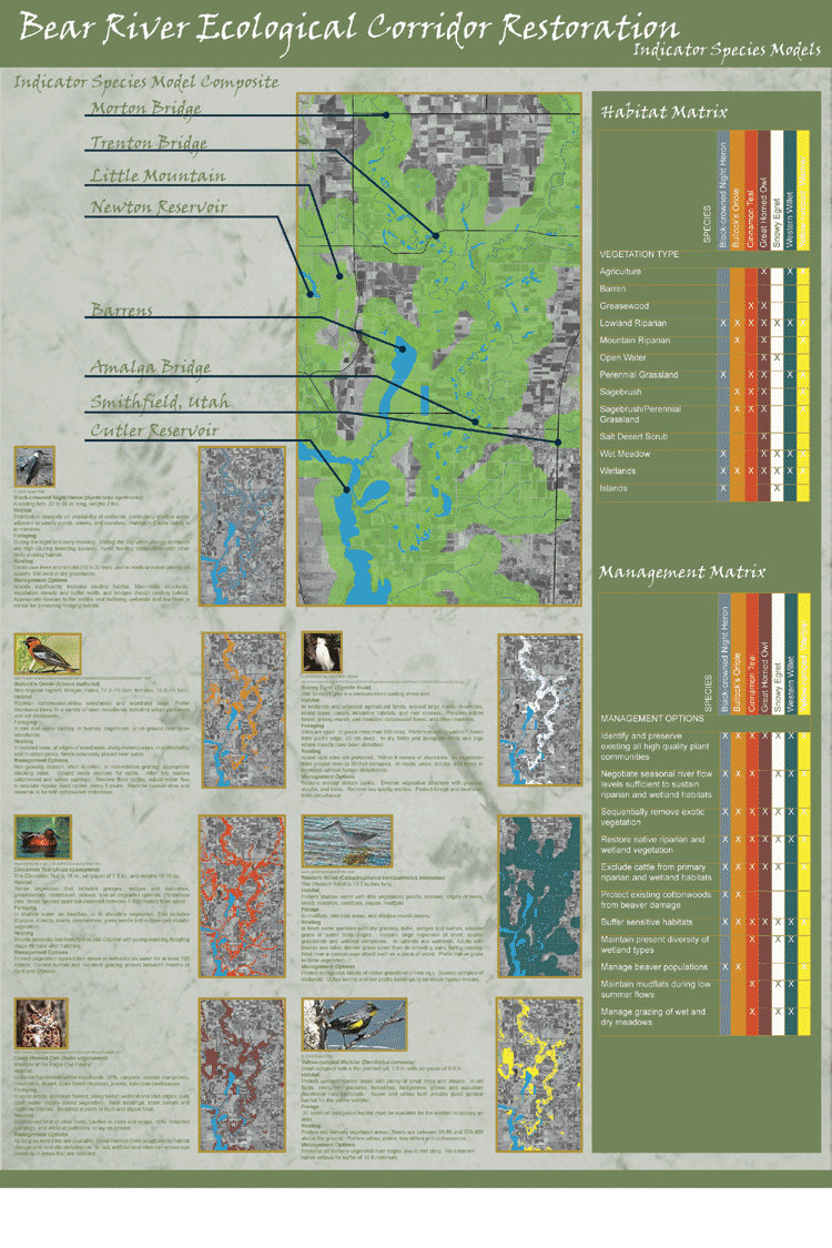
site along the Bear River corridor. Understanding ecosystem functioning
is a complex, perhaps impossible process. Some species of wildlife
however, are natural indicators of the ecosystem health around them.
The absence of these indicator species provides clues to possible
ecosystem degradation and may warrant closer attention to management
practices, land uses, development, and water/habitat quality. As
the project site is located within a major wildlife migratory route,
the team used seven avian wildlife indicator species to develop
habitat models. Using a combination of GIS vegetation data and ground-truthing,
the habitat models identified critical foraging and nesting habitat
for each species. The models were combined to outline an area of
the study site that is in the greatest need of restoration and active
management. The team then developed restoration and management options
for each habitat type.
The riverfront zone includes areas adjacent
to waterways, including the Bear River and its tributaries. Here
opportunities exist to
concentrate public access for the purpose of recreation while preserving
sensitive ecological areas. Riverfront areas also provide unique
educational opportunities for visitors. Main concerns include:
improved
public access for recreation and education, and integrity of ecologically
sensitive areas. Recommended actions include: develop safer,
easier
access to canoe launches and takeouts; expand and define parking
facilities; provide shaded picnic areas with scenic river and/or
valley vistas; install interpretive boardwalks and signage that
take user through wildlife habitat; construct viewing towers
and/or
lookouts; develop loop trails easily accessible by road, located
on Pacificorp property or other public or quasi-public land;
limit
livestock access to river; develop privacy buffers for adjacent
residences; and develop below grade trails at bridge crossings
for
safety. Physical actions in the riverfront zone focus on education
and preservation. Riverfront amenities include interpretive loop
trails, shaded picnic areas, parking and canoe launch facilities.
Again, vegetated buffers are used to concentrate and limit human
impact and protect residents’ privacy. At bridge crossings,
greenway trails are constructed below the road grade to enhance
user safety and experience.
The urban zone refers to the greater Logan area and includes the
cities of Smithfield,
Hyde Park, River Heights and Providence. This more densely populated
area warrants different treatments than the surrounding rural area.
The emphasis is on safety, water quality, links to surrounding areas
and the improvement and expansion of the green way network. Main
concerns include: safety for greenway users; water quality; linkages
to surrounding areas; and improvement and expansion of the greenway
network. Recommended actions include: enhance city gateway-greenway
intersections with consistent signage; improve safety at road crossings;
link urban communities to Bear River corridor; link existing parks,
schools, and public spaces through green infrastructure; and protect
aquifer recharge/discharge areas through acquisition and application
of land preservation tools. Urban greenway trails emphasize safety
features, accessibility, landscape buffers and connections between
parks, schools, public spaces and the Bear River corridor. Urban
pathways are generally a minimum of five feet wide, are paved with
asphalt or concrete and are separated from roadways by narrow landscaped
buffer strips. They can also function as alternative travel routes
for pedestrians and cyclists because they connect so many vital
urban hubs. Above-grade and well-defined at-grade greenway crossings
are used to improve user safety. Gateway features, such as signage
and public art, are used to improve town character as well as access
and visibility to the regional greenway.
The project team also outlined regional next steps including the
completion of a regional land use analysis for Cache Valley to assess
the suitability of all potential land use types in the valley. The
Bear River Bottoms Greenway is the green infrastructure or green
space component of the valley-wide regional master plan. The project
team also proposed the establishment of a greenway coordinator position
and greenway committee. These entities will work with agencies and
landowners to accomplish the objectives set forth in this plan.
Proposed responsibilities for a greenway coordinator include: funding
acquisition; coordination of resources; facilitation of land acquisition;
facilitation of design and development of site improvement recommendations;
operation and maintenance of greenway resources; accountability
to stakeholders; and working with local units of government to ensure
that new development accommodates greenway planning initiatives.
Implementation
Regional plans can offer strong vision but are not easily implemented
because a strong regional decision-making authority is often lacking
in western states. Who takes responsibility is often not addressed
because of existing independent jurisdictional structures. Using
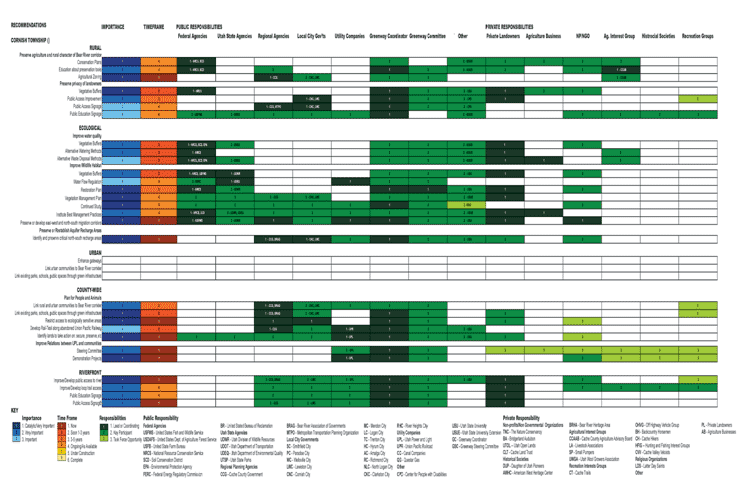
the township organization, the team developed township maps separated
into treatment zones. Included with each township’s treatment
zone map are recommendations by treatment zone presented in a matrix.
Each matrix lists the recommendations along the y-axis. The overall
importance (in shades of blue), the time frame for addressing the
issue (in shades of red) and the responsible players (in shades
of green) are listed along the x-axis at the top of each matrix.
Potential partners in implementation have been grouped for reading
ease, but a complete list with abbreviations is included at the
bottom of each matrix. The recommendations are a starting point.
It is expected that they will change as the physical and social
conditions of the study site are changed over time. In addition,
the team has developed an implementation toolbox, which provides
planning, policy, design and funding tools to implement the recommendations
of the plan.
|
|