|
Narrative Summary.
Project Motivation + Approach
"An urban growth boundary has been established to arrest Adelaide's
urban sprawl and encourage higher density residential redevelopment
closer to the city's center. This is a major policy shift that will
require Adelaide to grapple with the notion of denser urban development
and its associated environmental, social and economic implications
..." Planning SA 2000.
The project has been strongly influenced by the interconnected
theories of Ecology, Urban Ecology and Neighborhood Ecology. The
key theoretical ideas driving the approach to, and development of
the strategy are a hybrid of these theories. These ideas are:
- The significance of neighborhoods and suburbs as a key scale
in addressing the sustainability of existing urban areas through
policy and design strategies.
- Neighborhood and suburban strategies have the ability to ensure
site specific outcomes while being significant enough in scale
to have a meaningful impact.
- The city and neighborhoods within it must be understood and
approached as ecological systems.
- The urban environment, particularly the public domain should
be developed as multi-functional, productive and working landscapes
that integrate ecology, people and economy.
- Strategic incremental change is crucial when intervening in
existing suburbs. Incremental change is more manageable, feasible
and adaptable to local needs and values.
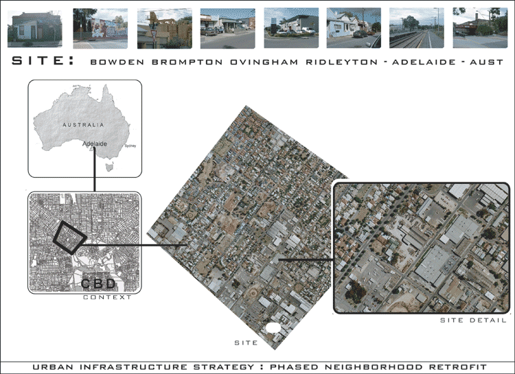
Site selection
The project site is the Bowden Brompton Ovingham Ridleyton neighborhood
of the city of Adelaide, South Australia, Australia.
This area of 2.24 square kilometers was Adelaide’s first suburb
and was selected for the following key reasons: It is a mixed use
suburb of industrial, commercial, retail and residential uses. It
is bounded by major transport spines from the north western suburbs
into the city and crossed by two rail lines. The combination of
the site’s diverse activity, location and history has created
a fascinating physical and social character. There is significant
vacant, derelict and under-utilized land with several typical urban
renewal projects currently underway. These elements provided a
topical
and challenging area to explore the issues outlined in the motivation
and approach.
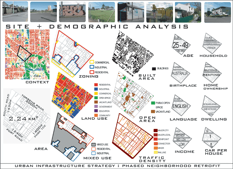
Site data and analysis methods
Compilation and analysis of historical, physical, existing planning
and demographical data on the site informed the planning strategy.
Historical timelines were developed to illustrate and understand
influences on the emergence of the site in its current form. Detailed
graphical studies of the existing planning, physical form and systems
of the site where undertaken. These studies focused on the role
of the site in its broader context, zoning, land use, built area
percentage, form, color and materiality, open areas of public space
and vacant land, streetscape character, existing vegetation, infrastructure,
traffic and circulation. The analysis summary diagrams illustrate
the following key points: The site’s form and character is
a reflection of its long, rich and complex history as an inner industrial
suburb. Existing zoning does not reflect the reality of the current
complex mixed land use of the site. The shadow of a pending government
freeway through the site in the 60’s and 70’s and the
resulting stagnation in development and decline in population has
produced significant areas of vacant, derelict or underused sites.
Despite this there is very little space allocated for public recreational
use. Traffic circulation is a critical issue; several major local
roads cross the site, also indiscriminate movement of heavier commercial
vehicles dominates the majority of streets. The two rail lines
intersecting
the site create another layer of movement. Detailed analysis of
census demographics information for the neighborhood was summarized
to illustrate key social patterns characterizing the community.
Key points in comparing the site to the city of Adelaide as a whole
are that: the 25-49 age group is dominant. There is a higher percentage
of migrants (English, Greek, Italian and Vietnamese ethnic groups)
and people who speak a language other than English at home. Higher
than average percentage of low income households. Recently there
has been an increase in the percentage of high income households.
40% of households are a single person. Also there are more couples
without kids. There is a higher percentage of renters, but with
buyers on the increase.
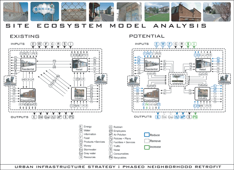
As part of the analysis of the site a conceptual ecosystem model
diagram of the existing site was developed to illustrate the components
that make up its ecosystem. While simplified, the diagram draws
attention to the systems inputs, outputs, flows and interactions
providing an illustration of the relationships within the system
and interaction with the broader city system.
The existing site diagram shows clearly the high amounts of both
inputs and outputs needed to maintain the current system.
This diagram was analyzed to determine feasible areas of intervention.
This resulted in the development of a proposed ecosystem model diagram.
Through the introduction of an internal multifunctional infrastructure
unnecessary or negative flows can be reduced or removed and other
positive contributing flows increased. This potential ecosystem
model translates onto the site as the Urban Infrastructure Strategy
and its key components.
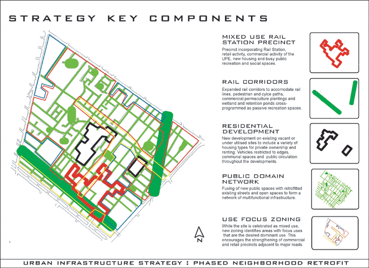
Planning Strategy
The strategy aims to develop, through the phased retrofit of the
existing site, a vibrant and sustainable mixed use urban neighborhood.
This will be achieved through the evolution of the public domain
into a dynamic and productive multi-functional infrastructure.
The public domain network will be cross-programmed with traffic and
pedestrian circulation, hydraulic purification and reuse, retail
and institutional activity, recreation opportunities and an innovative
community Urban Permaculture Enterprise (UPE). The UPE would be
affiliated with council, including direct community involvement
and would assume responsibility for integrating commercial permaculture
crops with other uses creating a unique and dynamic public domain
and generating revenue for the community. As part of the evolution
of this new public domain the two rail corridors that cross through
the site would be widened to allow this linear space to accommodate
these multiple functions. Phased policy and design would combine
to strengthen and build on the positive elements of the existing
mixed use neighborhood and reduce current conflicts. This would
include new mixed use developments incorporating the UPE operations,
a diverse range of housing options, a redeveloped rail station and
key elements of the multi-functional public domain. A restructured
street network that maintains commercial vehicle access while improving
pedestrian and cycle networks and residential street life would
link the entire site into these precincts creating an activated
multi dimensional environment of residential, retail, commercial
and recreational activity supported by and integrated with the
infrastructure that sustains it.
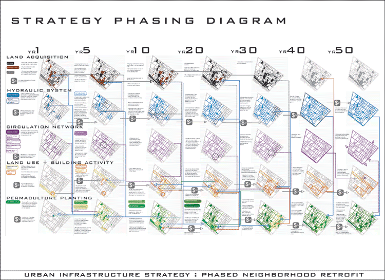
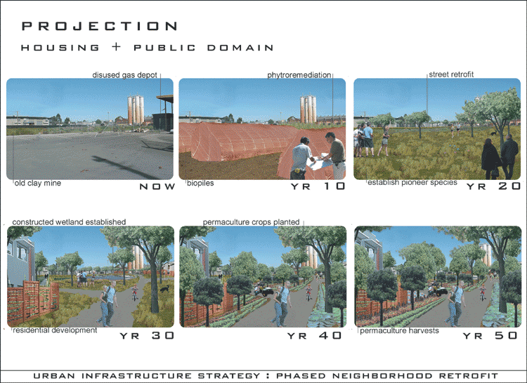
Phasing
An integral element of the Urban Infrastructure Strategy is the
phasing of its implementation over fifty years. The emphasis placed
on phasing is developed from the project approach and an understanding
of economic realities and timeframes for the establishment of processes
involving significant institutional and social change and the development
of organic systems such as wetlands. The phasing diagram illustrates
the progressive activity in the key streams of the strategy’s
development and the interconnections between them; land acquisition,
hydraulic system, circulation network, land use and building activity,
and permaculture plantings. The visible collation between the different
streams within a phase and across phases depicts the coordinated
and interdependent development required to successfully retrofit
the strategy into the existing site. For example the phasing diagram
explains how land must be bioremediated of contaminants before
productive
crops can be planted; how purifying wetlands must be established
if new residential developments are to receive recycled water;
and
how improved streetscapes can increase retail activity and help
fund the next phase. Key economic generators in the phasing of
the
strategy are depicted in simplified terms to demonstrate the consideration
of this important factor in its realization.
5 Key Phasing Streams
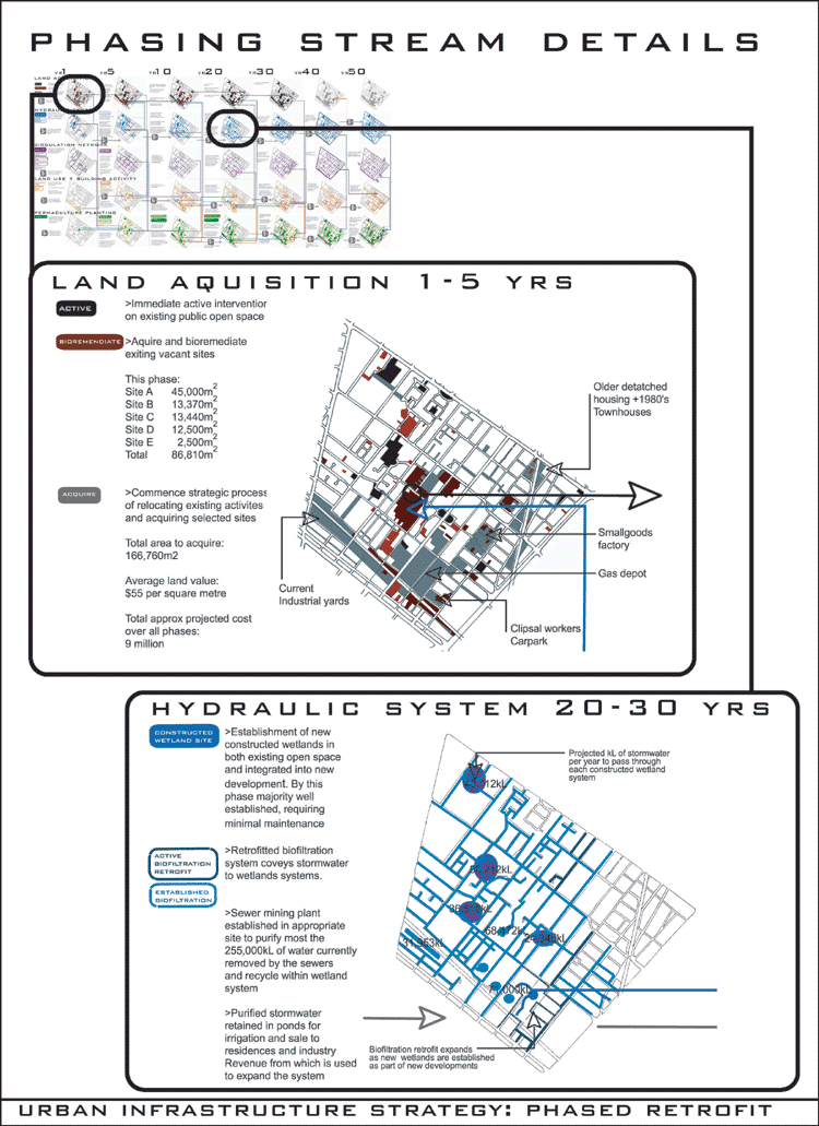
- The Land Acquisition stream indicates the areas of the site
which are actively transformed by the strategy. Areas of the site
selected for acquisition over time and for bioremediation of contaminants
are shown.
- The Hydraulic System stream shows the sites of the constructed
wetlands and retention ponds as they are implemented over time
and the development of the bioswale system for transporting water
to the wetlands as part of the retrofit of the existing streets.
- The Circulation Network stream displays the incremental restructuring
of the existing streets within a hierarchy of circulation needs.
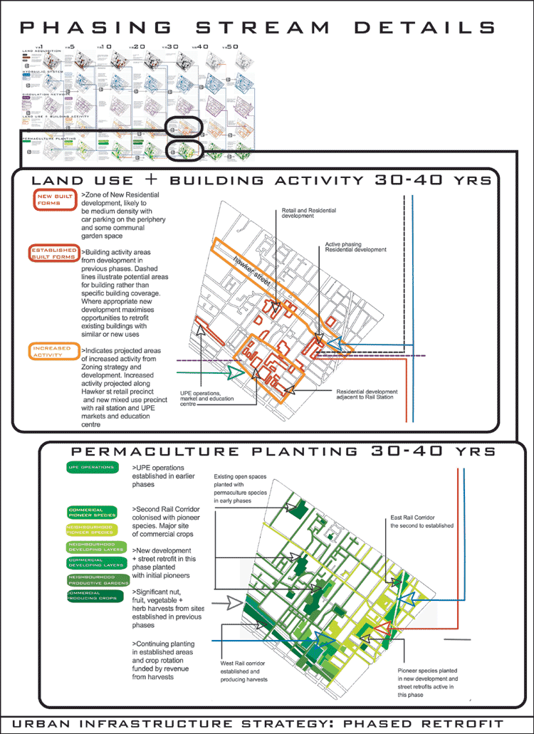
- The Land Use and Building Activity stream covers the key areas
of land use policy focus and shows the timing and sites of new
building development. It also broadly defines the areas of increased
activity that will result from this and have influence on future
phases.
- The Permaculture Plantings stream charts the planting of the
layers of the permaculture landscape on specific sites and their
maturation to productive crops.
The planning strategy, its implementation and design elements are
presented as a flexible, evolving framework for the future of the
site. The strategy elements are conceptual, procedural and technological
tools that will be monitored, evaluated, developed and will respond
over time to the changing needs and resources of the community allowing
it to emerge as an innovative, dynamic and sustainable urban community.
Economics
The phased implementation of the Urban Infrastructure Strategy is
an acknowledgement of the importance of economic feasibility for
the realization of the overall concept. Key elements of the economic
development of the strategy include:
Initial redirection and coordination of funding from existing council
and government budgets for storm water and sewer management, road
maintenance, public landscaping, local business incentive programs,
unemployment initiatives and other similar isolated programs. Major
initial injection of funding from the State or Commonwealth Government
to begin the acquisition and bioremediation process and establish
the UPE. In the long term the site will become far less reliant
on both Government funding directly and also on its broad scale
infrastructure. Major building developments will be undertaken by
private developers in close partnership with council and community
to ensure strategy aims are meet. A percentage of profits from sale
and rental income of redeveloped and new retail and residential
properties will be directed to the next phase of development. Increased
activity in the area increases profits of businesses who can contribute
financially to the strategy. Sale of purified water to residences
and industry funds ongoing maintenance and expansion of the hydraulic
system. Revenue from the sale of permaculture plants and harvests
is reinvested into the next phase of plantings.
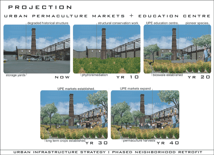
Urban Permaculture Enterprise
The Urban Permaculture Enterprise (UPE) is a concept for both a
new approach to our urban public space and the relationship between
local government, the community and commercial activity. Currently
council is responsible for providing and maintaining public spaces
such as streets and recreational open space. The restructuring of
council organization and redirection of funds would see the establishment
of an affiliated commercial enterprise with direct council and community
involvement. The enterprise would assume responsibility for the
landscaping of public space as a productive permaculture landscape.
The UPE would develop as a commercial company with its physical
operations based in retrofitted former industrial buildings as part
of the mixed use development adjacent to the rail station. The UPE
and the landscape developed and maintained by it, would evolve into
a dynamic, active, productive, educative and unique public domain
for the local community and which would draw people from surrounding
areas increasing social and economic activity. The UPE would activate
the council and the community focusing energy and skills within
the community into a positive enterprise with multiple benefits;
a sense of ownership and pride in a quality public space and locally
generated resources, skills, revenue, education and employment.
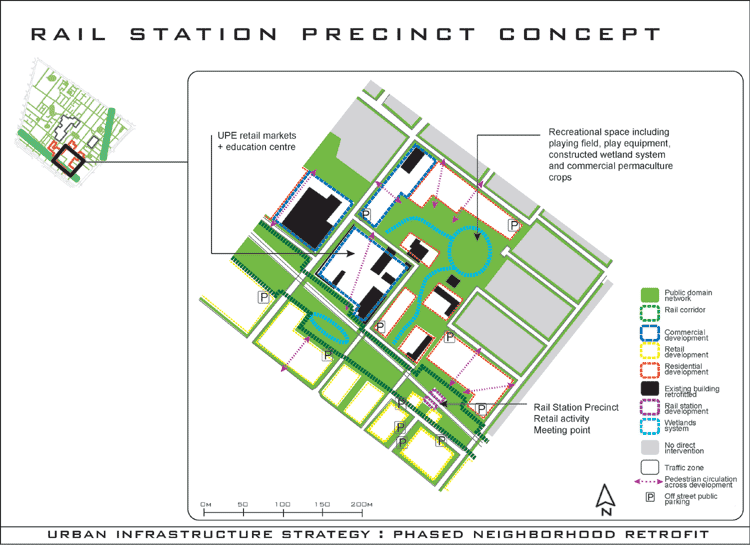
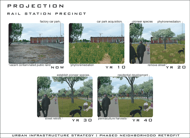
Key Concept Plan: Rail Station Precinct
The key concept plan acts as an example of the localized planning
and design through which the strategy would be realized on the
ground. The Rail Station Precinct would include areas of new residential
development, the public domain network incorporating constructed
wetlands and recreational spaces, redevelopment of the rail station
and adjacent commercial and retail premises. It highlights key existing
buildings that will be retrofitted as part of the Urban Permaculture
Enterprises’ retail and education center.
Prototypes
Connected to the phasing diagram and concept plan are Prototypes,
which outline key specific technologies and processes that are instrumental
in the implementation of the strategy. The prototypes are not intended
to present a conclusive palette of urban design details but rather
illustrate the key functional or technical information that would
guide their further development and importantly support the feasibility
of the strategy.
The key prototypes included in the strategy are:
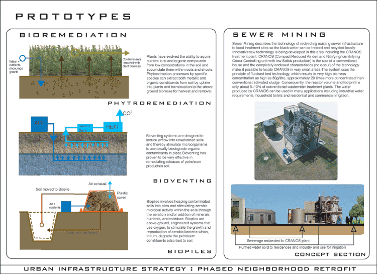
- Bioremediation: technologies for the removal of soil contaminants
using plants and micro organisms.
- Sewer Mining: a localized system for redirecting and recycling
black water from existing sewers
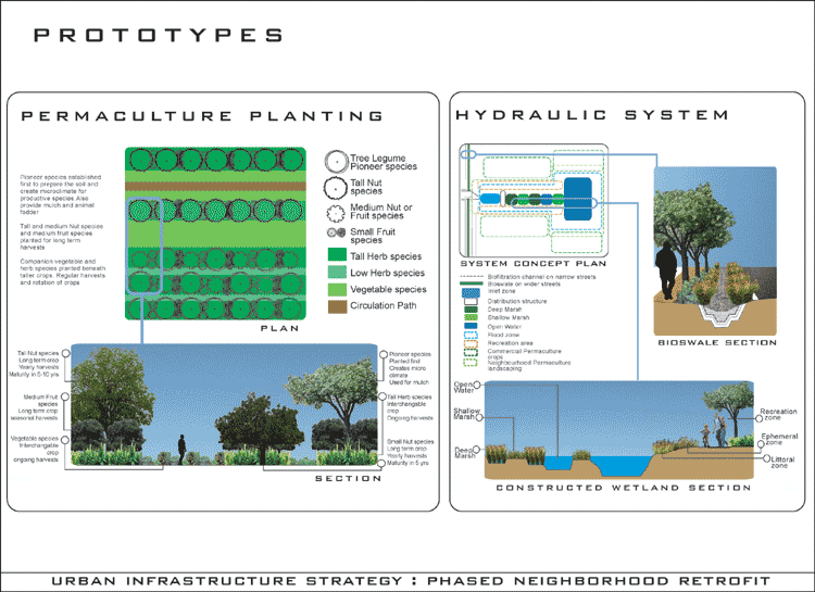
- Hydraulic System: elements for the purification of storm and
gray water via bioswales and constructed wetlands for reuse
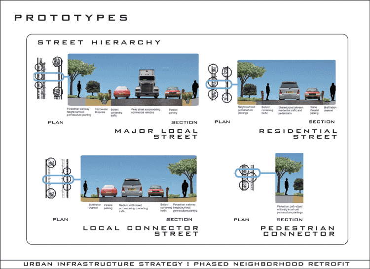
- Street Hierarchy: typical designs for restructuring streets
for improved pedestrian + bicycle circulation, infrastructure
and amenity
- Permaculture Planting: typical design of permaculture crop
layering, species selection and planting to harvest timeframes
Conclusion
The Urban Infrastructure Strategy aims to challenge conventional
frameworks, assumptions and priorities in urban planning and design,
specifically the function of the urban public domain. The strategy
presents possibilities for the integration of ecology, community
and economy at both the policy and organizational level and in the
physical landscape. The potential is a phased retrofit which evolves
the site into a dynamic sustainable urban system activated by a
multi-functional biophysical, productive and social public domain
infrastructure achieved through innovative policy, organizational,
technical, financial and ecological programmes and processes.
|
|