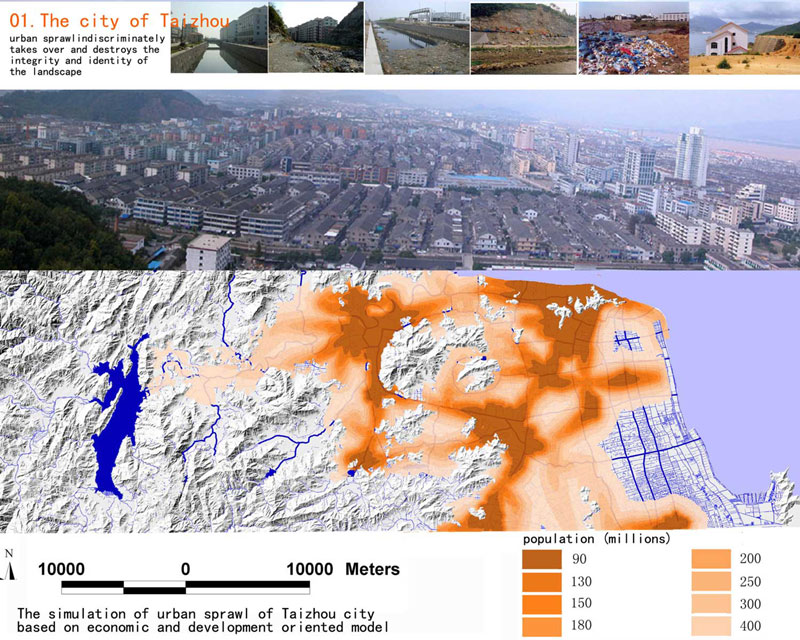
The urbanization in China increases about 1% annually. There is less than about 40% of the nation’s 1.3 billion population
now inhabiting urban areas, and this number will increase to more than 70% in the coming 15-20 years with cities sprawling
at an unprecedented speed. In the east coast area, where this project is located, the cities grow even much faster. In
this process, land is taken over indiscriminately for infrastructure construction and urban development. As a result, the wetlands
and water system on the land were destroyed and polluted, native habitats and biodiversity are getting lost, the hazards
of flood, drought hazards and diseases are increasing, and the cultural identity of the landscape is getting lost.
As a traditional approach, greenbelts were planned to stop the urban sprawl, but more than often they are realized only
on paper. One of the main reasons for the failure of greenbelt concepts is that they are usually planned more artificially
and arbitrarily than the urban development itself, with functions only as barriers to stop the urban sprawl processes. New and
effective tools have to be developed to address a wise and sustainable development of the limited land.
Taizhou is located at the southeast coast of China, with a total area of 9411 square kilometers, and a population of
5.5 million. Among them only 0.7 million people are now living in the urban area, and the urban population will increase
to 0.9 million in 2010, 1.3 million in 2020, and 1.5 million in 2030. Though quite rural and agricultural, it is now one
of the fastest growing areas in China due to the booming of the small private industries. Under the influence of the monsoon
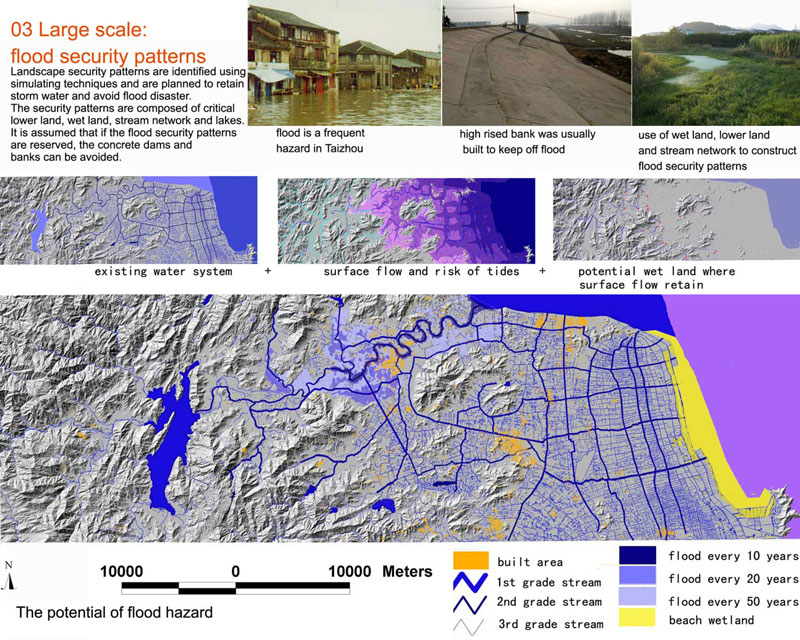
climate and being adjacent to the east sea, flooding has been a major hazard. As an adaptation to the storm water and flood
problem, the landscape has been shaped into a unique form featured with a network of water courses that integrate natural water systems, wetlands and man-made ditches, as well as cultural
heritages such as bridges, dikes, dams, and vernacular landscapes. This area has long been famous for the rice, fishery and citrus. It is also critical to keep in mind that arable and developeable
flat land is very limited in this area.
This water network landscape, which has been effective in safeguarding the agricultural processes for thousands of years,
is now facing the challenge of being destroyed by the speedy urbanization process beginning in the earlier 1990s. The wetlands
have been filled, rivers have been straightened and channelized, cultural heritages that are not listed as protected historical
relics have been destroyed, and visual and recreational experiences have been totally ignored.
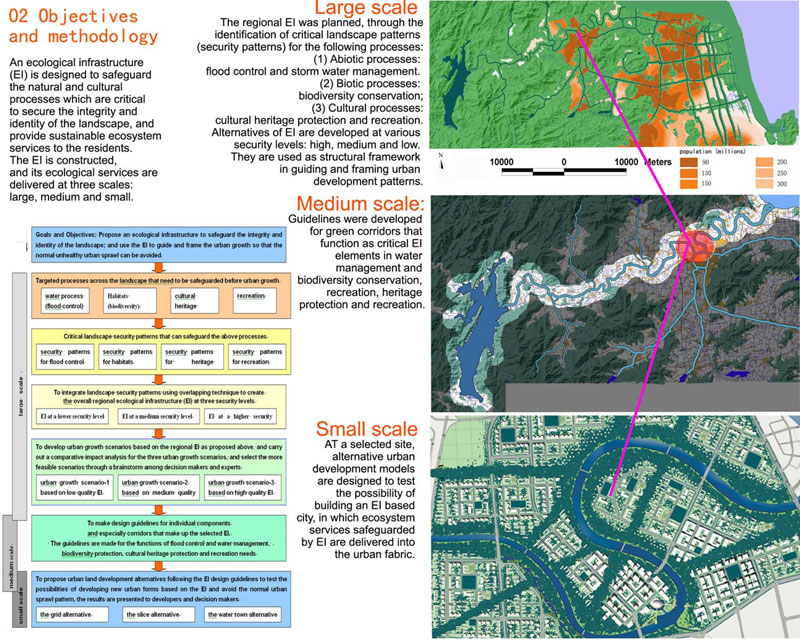
In addressing the above situations, a project was outlined to guide the urban sprawl and safeguard the sustainability
of the living land, using a minimum amount of land for the natural and ecological considerations.
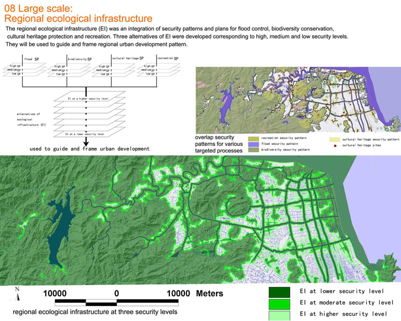
In this project, the planners take land as a living system, and develop an ecological infrastructure (EI), to guide and
frame the urban sprawl. The EI is defined as the structural landscape network that is composed of the critical landscape elements and spatial patterns that are of strategic significance in safeguarding the integrity and identity of the natural
and cultural landscapes and securing sustainable ecosystem services, protecting cultural heritages and recreational experience.
Like the urban infrastructure providing social and economic services (such as transportation, gas, sewage, etc.) that
support the potential urban growth, the EI safeguards ecological services, protecting cultural heritages, providing visual
and recreational experiences.
Three categories of processes are targeted to be safeguarded by the ecological infrastructure:
(1) The abiotic processes: the main focus is flood control and storm water management.
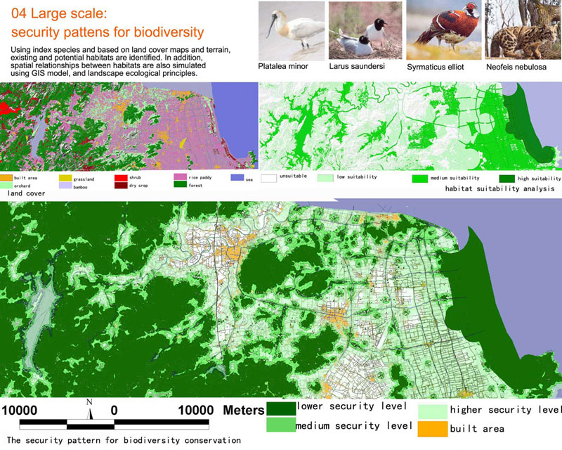
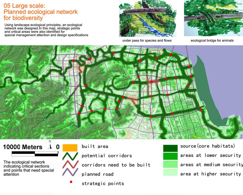
(2) Biotic processes: native species and biodiversity conservation.
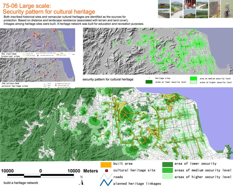
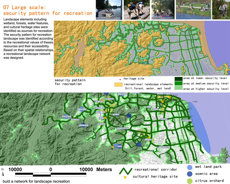
(3) Cultural processes: including heritage protection and
recreational need.
A geographical information system (GIS) was established to
store, overlay and analyze layers of natural, cultural and
social economic data.
The regional EI was planned through the identification of
critical landscape patterns (security patterns) for the targeted
processes. The security patterns are composed of elements
and spatial positions that are strategically important in
safeguarding the different processes of the landscape. Models
including suitability analysis, minimum cost distance and
surface models were used in the identification of security
patterns for the individual processes.
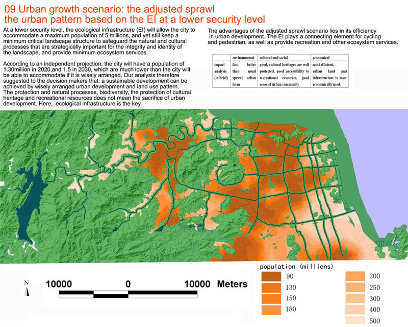
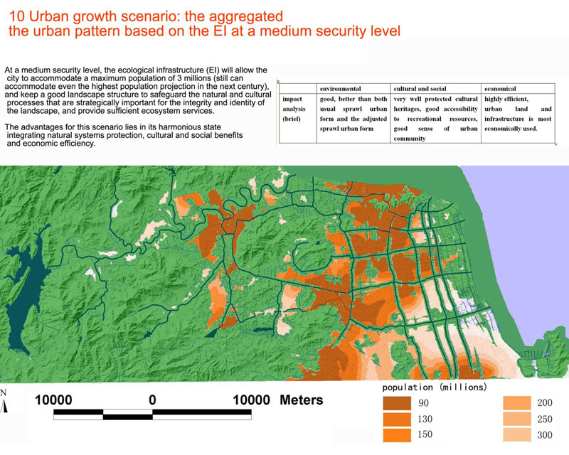
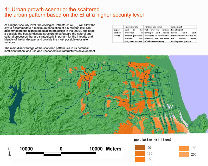
Three security levels - low, medium and high - are used to define the quality of the security patterns in safeguarding
each of the targeted processes.
Using overlaying technique to integrate the security patterns for individual processes, alternatives of regional ecological
infrastructure are developed at various quality levels: high, medium and low.
Using the three EI alternatives as framing structure, scenarios of regional urban growth patterns were simulated using GIS:
the Adjusted Sprawl Scenario, the Aggregated Scenario, and the Scattered Scenario.
Comparative impact evaluations were made for these scenarios by a planning committee composed of decision makers of the
city, planning experts from all over the country, stake holders who are represented by officials from various functional departments
of the Taizhou city government (including the departments of agriculture, water management, forestry, industry, tourism,
finance, transportation, public affairs, security, culture education, tax, etc.), and representatives of individual villages
who originally owned the land, representatives of real estate developers and representatives of investors who are eagerly
waiting to get the right to develop the land.
One of the three urban pattern scenarios was finally selected as the most feasible by the decision makers, after a long
time and multiple brainstorms among the planning committee. As expected the Aggregated Scenario, which is based on the
medium quality EI, was considered the more balanced and less difficult to be realized.
Green lines were drawn to define and safeguard the EI protection. These basic green lines are now being presented to the people’s
congress of Taizhou City for legislation procedure. After being passed by the congress, these green lines will become the first of their kind in China to protect the regional
ecological infrastructure by the municipal law..
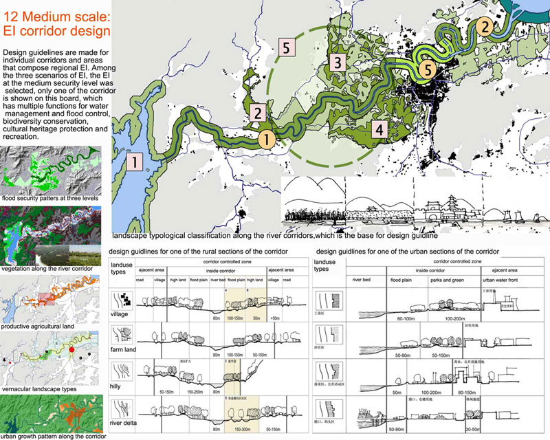
Based on the aggregated Scenario and the green lines of the regional EI, overall design and management guidelines were
developed for the medium quality EI, and especially for the green corridors that function as critical EI elements in water
management and biodiversity conservation, heritage protection and recreation.
During this process of making design guidelines, time consuming interactions were made between the planners and local people, especially the local villagers whose land is either going
to be developed or protected.
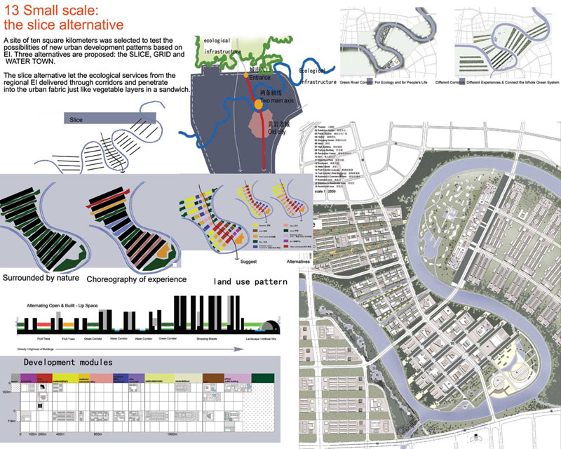
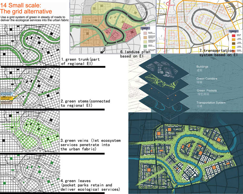
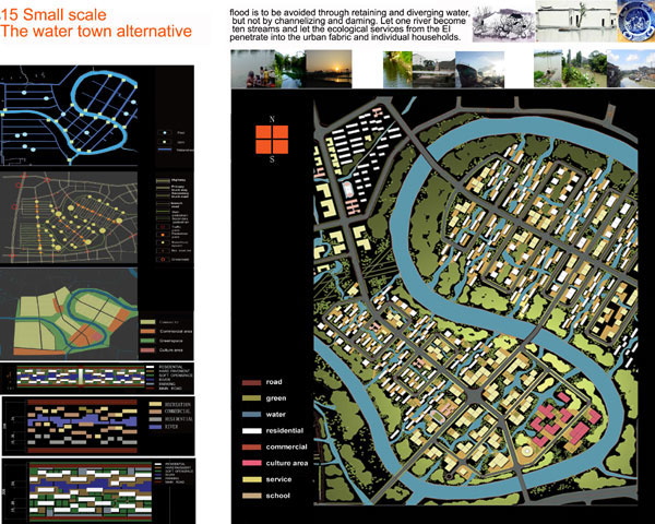
At a selected site (10 square kilometers in size), following the EI guidelines developed above, alternative urban development
models were designed to test the possibility of building an EI based city. In these ecosystems, services safeguarded by EI are delivered into the urban fabric so that the usual urban
sprawl can be avoided.
These new urban land development models were presented to the developers and investors, as well as the city decision makers, to let them know that the business-as-usual models
of land development can be avoided. The new way of development by building the EI into their land use scheme will not only help the whole city, but will also benefit the onsite development
ecologically and economically.
These schemes show how the regional and large scaled EI can be realized also at the local and small scale land development to handle the problem of urban sprawl.
|