American Society of Landscape Architects

  2004 ASLA Professional Awards


Design Award of Merit

The Eastbank Esplanade, Portland, OR
Mayer/Reed, Portland OR
Clients: Portland Development Commission; Portland Parks and Recreation; and Oregon Department of Transportation

Portland does it again with a brilliant bike path. . . Elegant, strong forms with successful engagement of riverfront.
           2004 Professional Awards Jury Comments

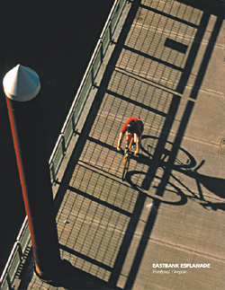
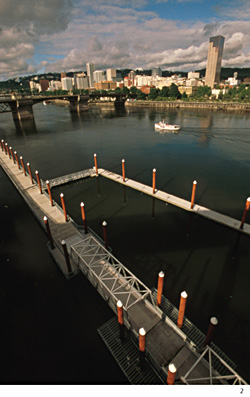
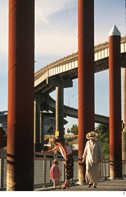
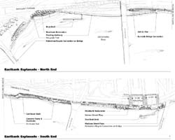
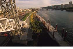
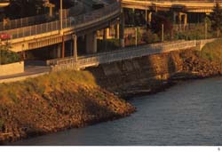
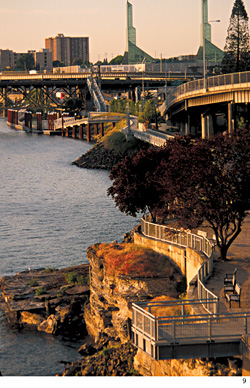
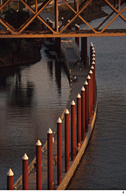
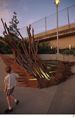
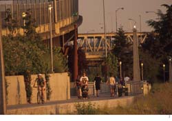
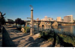
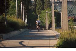
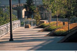
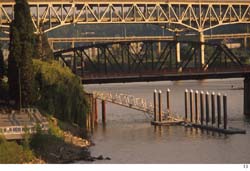
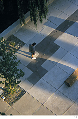
The Eastbank Esplanade is a multi-phase project completing a continuous three-mile pedestrian link that circumnavigates the Willamette River in downtown Portland. The project features a 1,000-foot long floating walkway, promenade and continuous seat wall, plazas, overlooks, a cantilevered walkway, bioengineered banks, lighting, interpretive site amenities, public art, and a 70-foot tower that connects the trail to an existing bridge and landscape improvements. Boat docks at the north and south ends provide moorage for tour boats and water taxis. Simple geometric design forms are rendered in timeless industrial materials of concrete and steel. In addition, the use of native stone and plants recall the context of the river environment and its underlying geology.


Eastbank Esplanade (Photo: Bruce Forster Photography)

The floating walkway reveals new views of the Willamette River and Portland's downtown skyline. (Photo: Bruce Forster Photography)

Users of the floating walkway enjoy safe and intimate contact with the water. (Photo: Bruce Forster Photography)

Illustrative plan of the Eastbank Esplanade. (Drawing: Mayer/Reed)

A steel staircase enclosed in a truss structure enables pedestrians to descend 43 feet down from the Burnside Bridge to the Esplanade. From this point, users can access the esplanade from eastside neighborhoods or from downtown to the west. The Esplanade links horizontally to the south end of the floating walkway as seen on the right. (Photo: Bruce Forster Photography)

This east facing view illustrates trail design using an industrial remnant seawall from the 1915 Municipal Terminal 2. The cantilever walkway consists of a 400-ft. long steel deck set onto concrete-encased steel beams that project through the seawall. Pedestrians appreciate the expanse of the adjacent seawall and water below through steel grating; while an on-grade trail behind the seawall provides an alternative route for maintenance vehicles and bikes. (Photo: Bruce Forster Photography)

Overview of the Esplanade looking north. The Esplanade links a number of unique pedestrian spaces along the Willamette River as it flows through downtown Portland. Placement of cantilever steel decks over an existing concrete slurry left from the adjacent bridge construction in the 1950s reveals an existing site artifact. (Photo: Bruce Forster Photography)

The floating walkway provides a trail connection where the bank disappears under the freeway. Designed for ADA access, the walkway accommodates a river fluctuation of over thirty vertical feet seasonally. (Photo: Bruce Forster Photography)

Integrated works of art punctuate and highlight four distinct locations along the Esplanade. These site-specific art installations conjure myriad interpretations of the river's moods and history. (Photo: Bruce Forster Photography)

Continuing south, the on-grade trail varies in width from 12 feet to more than 30 feet at the south end of the Esplanade. The trail section includes dense, textural native plantings adjacent to the freeway and on riverbanks, steel decks, art, urban markers, and lighting. (Photo: Bruce Forster Photography)
Steel decks and interpretive panels create stopping places along the bank and provide new views for park users. (Photo: Bruce Forster Photography)
In this foreshortened view, a series of urban markers designate each block where Portland city streets historically met the waterfront. Dense, colorful plantings that include native trees and shrubs, such as flowering currant, Douglas spiraea, redosier dogwood, and rugosa rose, provide a buffer from the adjacent freeway. (Photo: Bruce Forster Photography)
Salmon Street Plaza (in a view northward) is a place where community events, such as the annual Portland Wooden Boat Festival, are now held. Native basalt stone planters integrated into the plaza design function as infiltration basins. Willows and ash trees in the planters absorb run-off from the plaza and trail. (Photo: Bruce Forster Photography)

Looking southward, a cantilever steel deck extends Salmon Street Plaza over new bioengineered riverbanks that replace steep riprap slopes. The trail and plaza were designed to retain many existing mature upland trees. A dock for tour boats and river taxis, creates a new water connection near the Hawthorne Bridge at the Madison Street Plaza (not in view.) (Photo: Bruce Forster Photography)
At the south end, the Madison Street Plaza features a granite river map of the Willamette from its confluence with the Columbia River south to its headwaters. The etched tactile map works as a wayfinding and interpretive element for park users as well as visitors boarding or departing tour boats. (Photo: Bruce Forster Photography)

Awards Press Release |  Awards Home