American Society of Landscape Architects

  2004 ASLA Professional Awards


Analysis & Planning Award of Merit

Preserving Native Texas: A Master Plan for the Fort Worth Nature Center and Refuge, Fort Worth, TX
MESA Design Group, Dallas, TX, and The Portico Group, Seattle, WA
Client: City of Fort Worth Parks and Community Services Department

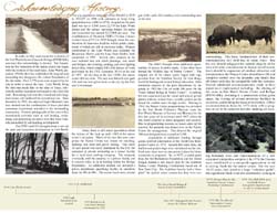
Good process, research and graphics presentation. . . Smartly detailed plan for a course of action. . . Strong analysis and response to context. . . Comprehensive treatment from a large-scale re-conceptualization of the area to sensitive treatment of spaces and materials. The authors are to be commended for looking at the economic functionality of the solution.
           2004 Professional Awards Jury Comments

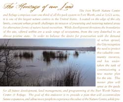
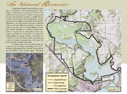
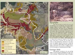
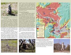
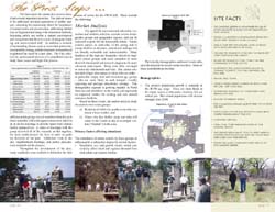
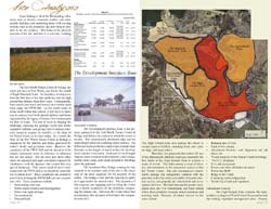
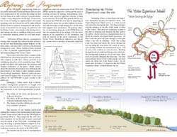
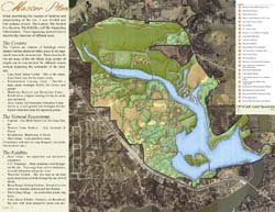
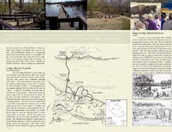
At 3,621 acres, the Fort Worth Nature Center & Refuge comprises over one third of the parkland in the City of Fort Worth, TX, and is one of the largest nature centers in the United States. Located on the edge of the city limits, constant urban growth challenges its mission of preserving and restoring natural areas. The plan’s goal is to accommodate future expansion and allow more people to experience the value of the Nature Center, while preserving "wild" areas to maintain the integrity of the land. The mission of the plan is to establish a signature heritage for the nature center that reflects not only the regional character, but also communicates the community’s values in preserving natural open space for future generations.


Preserving Native Texas: The site is a 3,600 acre preserve located 10 miles northwest of Downtown. With 100-150 thousand visitors per year, a full time staff of seven, and an annual operating budget of $300,000; the facility struggles to expand its programming and preserve its resources while fighting the demands of urban sprawl. (MESA Design Group)

The Heritage of our Land: In the distance, signs of development begin to encroach into the view sheds of the refuge. (MESA Design Group)

Acknowledging History: Decades of demographic and recreational use changes have influenced the perception of the FWNC&R. A timeline of the site's history was developed to track the progress to date. (Photo: Fort Worth Nature Center and Refuge Library)

The Natural Resources: The topography of the site consists of four natural promontories (with elevation change across the site of over 100 feet), where a person can see almost the entire site and even reaching as far as downtown. From a hydrologic standpoint, 50 % of the Nature Center lies within the 100-year floodplain. The watershed encompasses the West Fork of the Trinity River, several creeks, two natural springs, and the two adjacent recreational lakes creating a diverse aquatic community within the site. (Photo: Lopez Garcia Group)

Topography, Geology, and Soils: In Tarrant County, there are eight different soil associations, all of which converge on the Nature Center, a very rare situation. The geology is exposed at the surface as limestone cap rock at the highest elevations (forming an escarpment-like community) and migrates through layers of sandstone down to the river clay. The three significant vegetation communities include the Grand Prairie (open expanse of tall grasses), the Cross-Timbers (belts of oak forest mixed with prairie grasses), and the Trinity bottomland (forests of elm, ash, oak, pecan, box elder, and willow). A particularly important place is Todd Island, containing one of the oldest undisturbed areas indicating forests dating back to 1736. (Photo: Lopez Garcia Group)

Wildlife and Cultural Resources: In contrast, there are several native and non-native species of plants (more than 650) that create diverse ecosystems for wildlife habitats. These include a herd of 6 bison that roam 55 acres, a prairie dog town, and one of the top ten birding sites in Texas with over 200 species of birds. (Dean Runyan Associates – Charts, MESA Design Group – photos)

The First Steps: As its complete name attests, the facility is both a nature center and a refuge with two inherent, and sometimes contradictory missions. It must sustain the interrelated natural systems while creating a critical mass of natural learning and social interaction. By looking at comparable facilities and population demographics, we drew conclusions about our projected visitor groups and the type of activities it takes to attract them to the facility. (Dean Runyan Associates – Charts, MESA Design Group – photos)

Site Analysis: Each zone of the site was carefully scrutinized for the differences in the resources, surrounding development, and programming. 108-09) Refining the Program: By applying the visitor experience model to the site's intended public use zones, a concept plan is born that begins to establish a network of activity zones and exhibits. Displayed in the loop road that follows the top of the high ground or MESA, the circulation system touches on all ecosystems present at the site supporting the goal of taking the visitor on a journey across ecosystems to further educated them about the differences and importance of protecting them (MESA Design Group)

Refining the Program: By applying the visitor experience model to the site's intended public use zones, a concept plan is born that begins to establish a network of activity zones and exhibits. Displayed in the loop road that follows the top of the high ground or MESA, the circulation system touches on all ecosystems present at the site supporting the goal of taking the visitor on a journey across ecosystems to further educated them about the differences and importance of protecting them (black and white diagrams – The Portico Group, Color images – MESA Design Group)

Recommendations: Many land use, resource, and operations recommendations were developed that included surrounding edge conditions such as: attempt to buy visual easement rights; acquire the in-holding properties as they become available; eliminate incompatible uses such as the gun range; strike a mutually beneficial use agreement with Tarrant County Water District for land adjacent to the dam; and annex property along Jacksboro Hwy and all farmland within watershed. (MESA Design Group)

Master Plan: The site was divided into four systems of use: The Centers, the Natural Ecosystems, The Exhibits, and The Supporting Infrastructure. These include a new visitor center, the reutilization of the existing center as a higher learning facility for study and instruction, a new Environmental Learning Center that provides a large group overnight facility for various user groups potentially with ISD partnerships, and a new Environmental Education Camp for staff guided groups. (MESA Design Group)
Lone Point Visitor Center: Schematic concept sketches of the Lone Point Visitor Center included floor plans and elevations, which began to determine the proposed character of how a new facility should derive its materials from the landforms. With a large promontory on the back of the building and a lookout tower, the facility acts as a beacon along the new main entry drive along the lake. Existing CCC structures at the site would be incorporated into the new architecture while preserving these remnants of the historical past. (Color perspective Tom Sherrill Illustrations, photo and diagrams – MESA Design Group)
Exhibits: The Exhibits along the loop road consist of two venues - man-influenced or a natural wildlife habitat. One of the man-influenced exhibits is a new canoe launch connecting to Greer Island to promote non-motorized boating recreation within the facility. Wildlife exhibits include the addition of a waterfowl stop where observation of birds through the use of blinds both family and classroom size groups would be strategically placed, the bison range which would be expanded from the existing 55 acres to over 500 acres so that nomadic animals and their habitat can be interpreted and utilized as a land management tool, and the Lotus Marsh would also be expanded to include more interactive docks and a small amphitheater for classroom instruction on aquatic ecosystems. Dozens of plans and sketches were developed for each of these exhibit areas. (black and white sketches – Tom Sherrill Illustrations; Photo and map - MESA Design Group)

Implementing the Strategy: A thorough cost estimate and priority matrix was developed to allow a phased migration of the plan. The steering committee was instrumental in prioritizing each of these elements in order to achieve the greatest benefits in each phase. (MESA Design Group)
Milestone of an action plan: The final product of the master plan resulted in a booklet to communicate all of the research, data, analysis, and reasoning behind the plan. This documentation serves as a guide to organizing the future steps of progress. (MESA Design Group)

Awards Press Release |  Awards Home