
.webp?language=en-US)


Run with the Flood—A Symbiosis System of Flood Mitigation and Salmon Habitat Restoration
Mengqing Yu, Student International ASLA; Hui Tang; Xiting Huang; Yuling Song; Chang Liu; Qiaoyun Lu
Run with the Flood—a waterway intervention that addresses river flooding and salmon habitat conservation—is a good implementation tool that seems highly-feasible. The thought of tying flooding directly to salmon migration and other species isn’t something you see often, and it sets it apart. The data is well-presented, uses a thorough analysis, and their methodology could be applied elsewhere to other wildlife habitats.
Awards Jury
-
The Tillamook Bay watershed has a long history of flood events and salmon fishing. Over the years, people placed hundreds of stream barriers against floods. These infrastructures created bottlenecks throughout the watershed and caused many issues for fish and the community. Besides, the broken river system has prevented much habitat restoration and protection for decades. So, there is a growing call for removing these barriers and getting Salmon "Back to the River”. This is a historic opportunity and challenge for Tillamook.
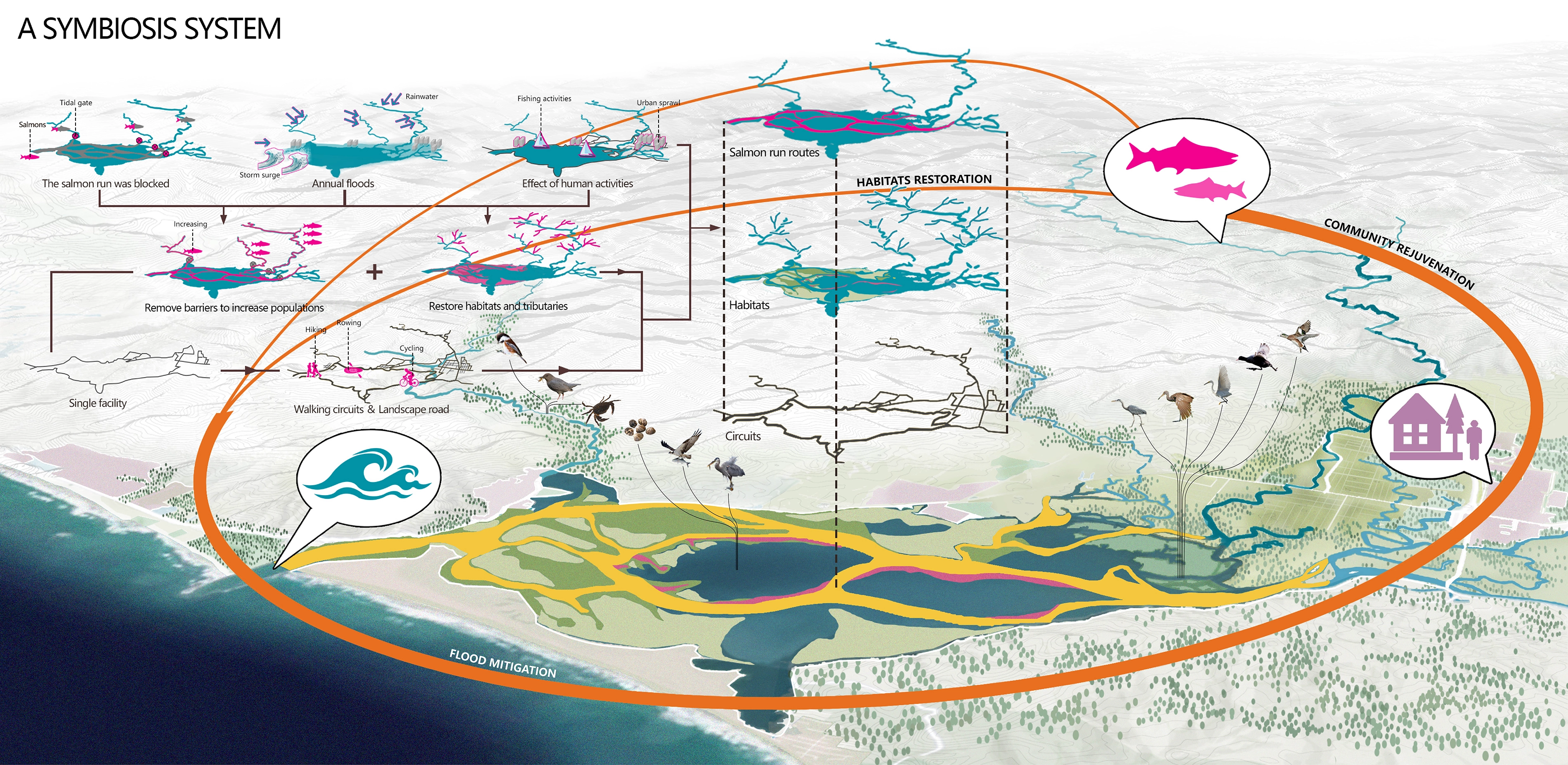
Instead of traditional prevention-led approaches in flooding management, this experimental project attempts to seek a symbiosis way of living with potential flooding and salmon habitat conservation. We hope to intervene in the environment of rivers, estuaries, and bays through three phases of the salmon run route: spawning, migration, and rearing, to re-establish "habitat connectivity" for salmon, to reconnects more historic habitat, reduces chronic flooding, improves the resilience of the area while recreating opportunities and stimulates the local economy.
-
Ⅰ.Project Background
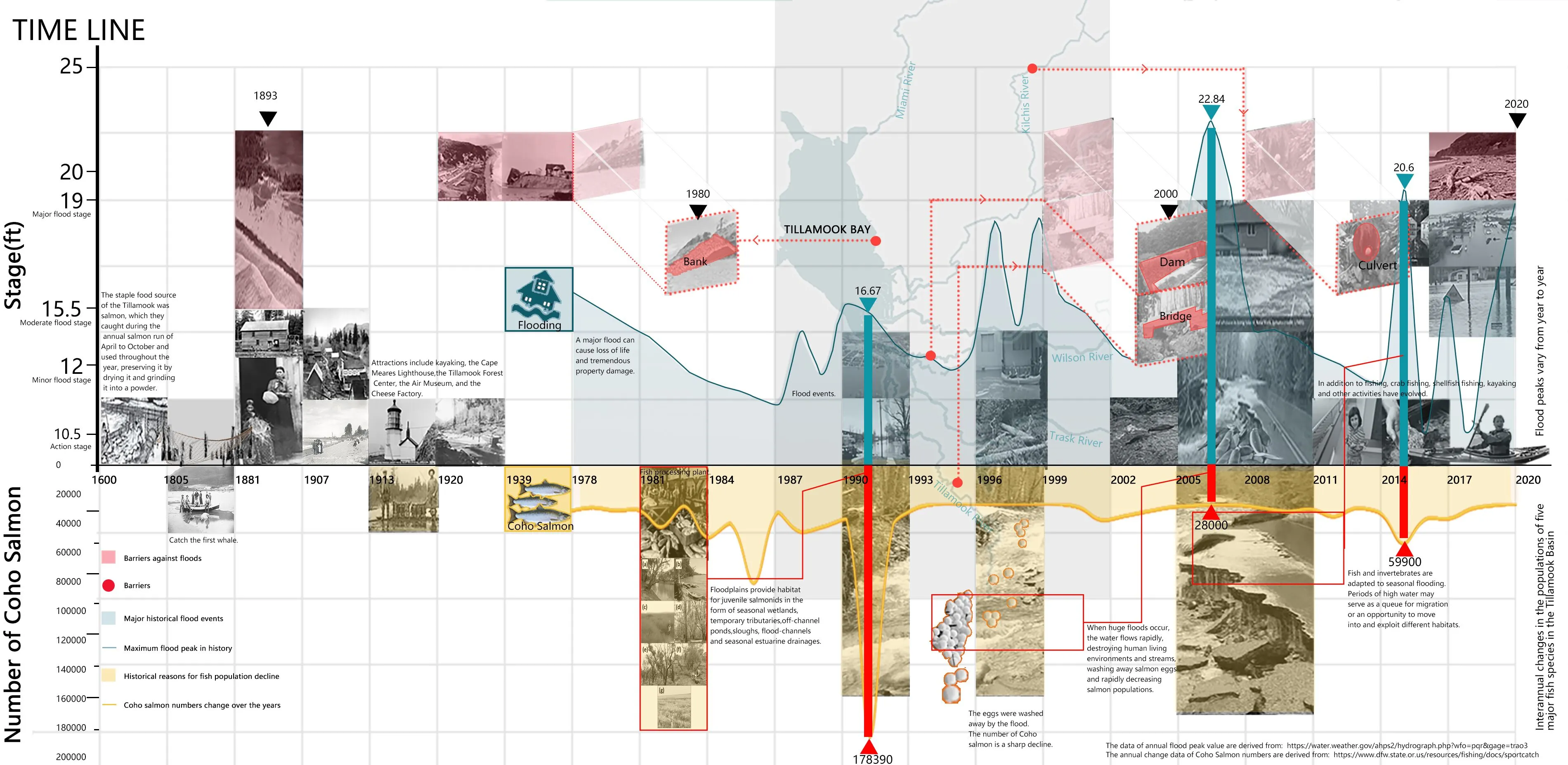
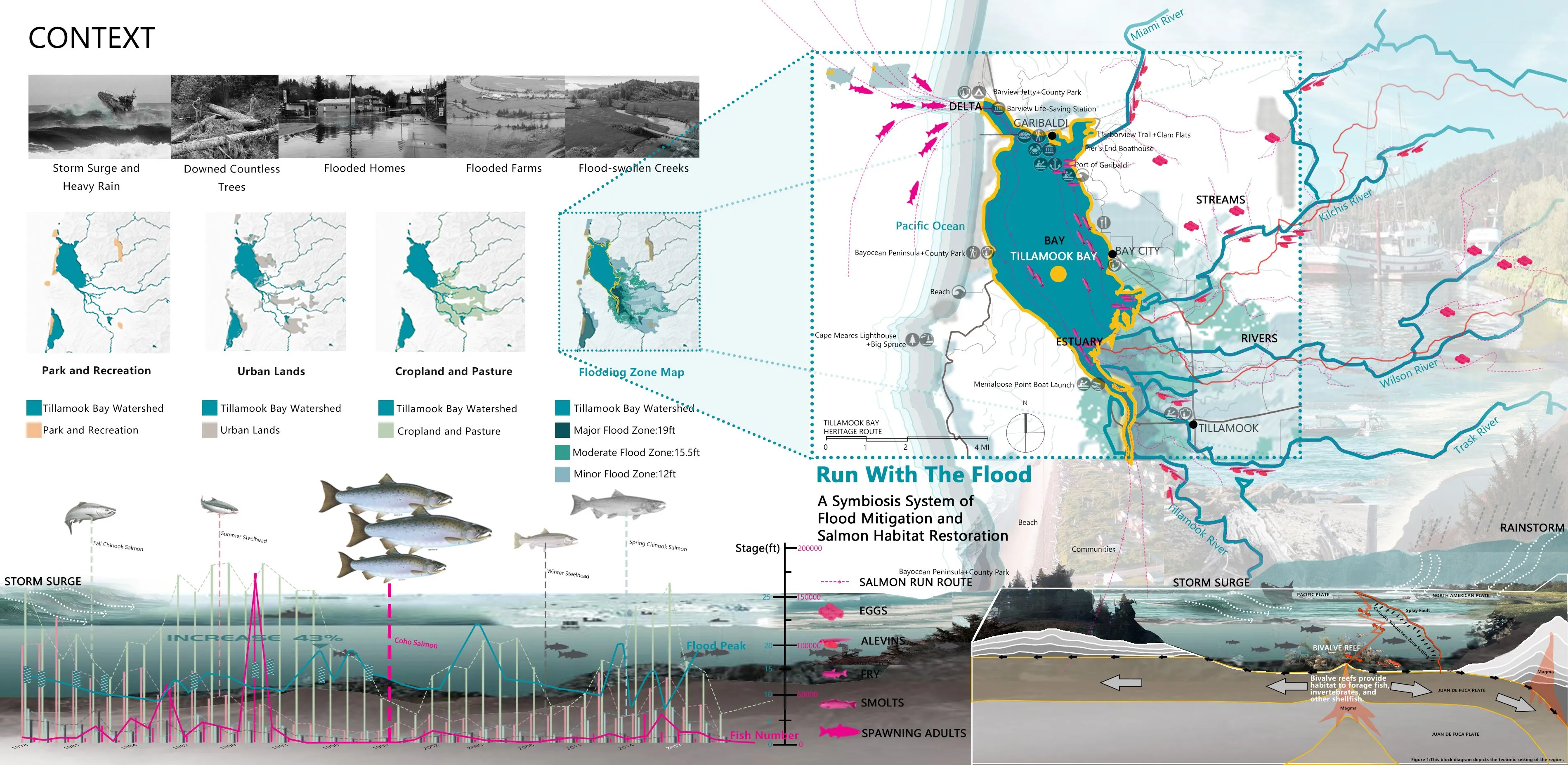
Tillamook Bay Watershed has an extensive history of flooding typically caused by large-scale weather systems generated by prolonged rainfall or rain-on-snow events generating large amounts of runoff. The area is also subject to coastal flooding from high tides and wind-driven waves. After the flooding, properties and structures in the flood-prone areas were badly destroyed.
Infrastructure such as dams, weirs, regulators, and culverts have reduced the longitudinal and lateral connectivity of Tillamook’s river-floodplain systems, through the presence of physical barriers and the reduction in flooding. Stream barriers had severe impacts on the salmon run (The salmon run is the time when salmon migrated from the ocean, swim to the upper streams where they spawn on gravel beds). Fragmented fish population leading to loss of upstream biodiversity and fish population declines. Eventually, the watershed resilience declines also.
Salmon plays a very important role in the local culture and economy for a long time, they want them back to their common home. The Salmon population is declining and even partially listed as endangered species (ESA). Combined with the more frequent storm surges caused by global climate change, the flood problem in Tillamook Bay Watershed is increasingly severe. Therefore, Tillamook Bay Watershed urgently needs more ecological and resilient flooding management approaches.
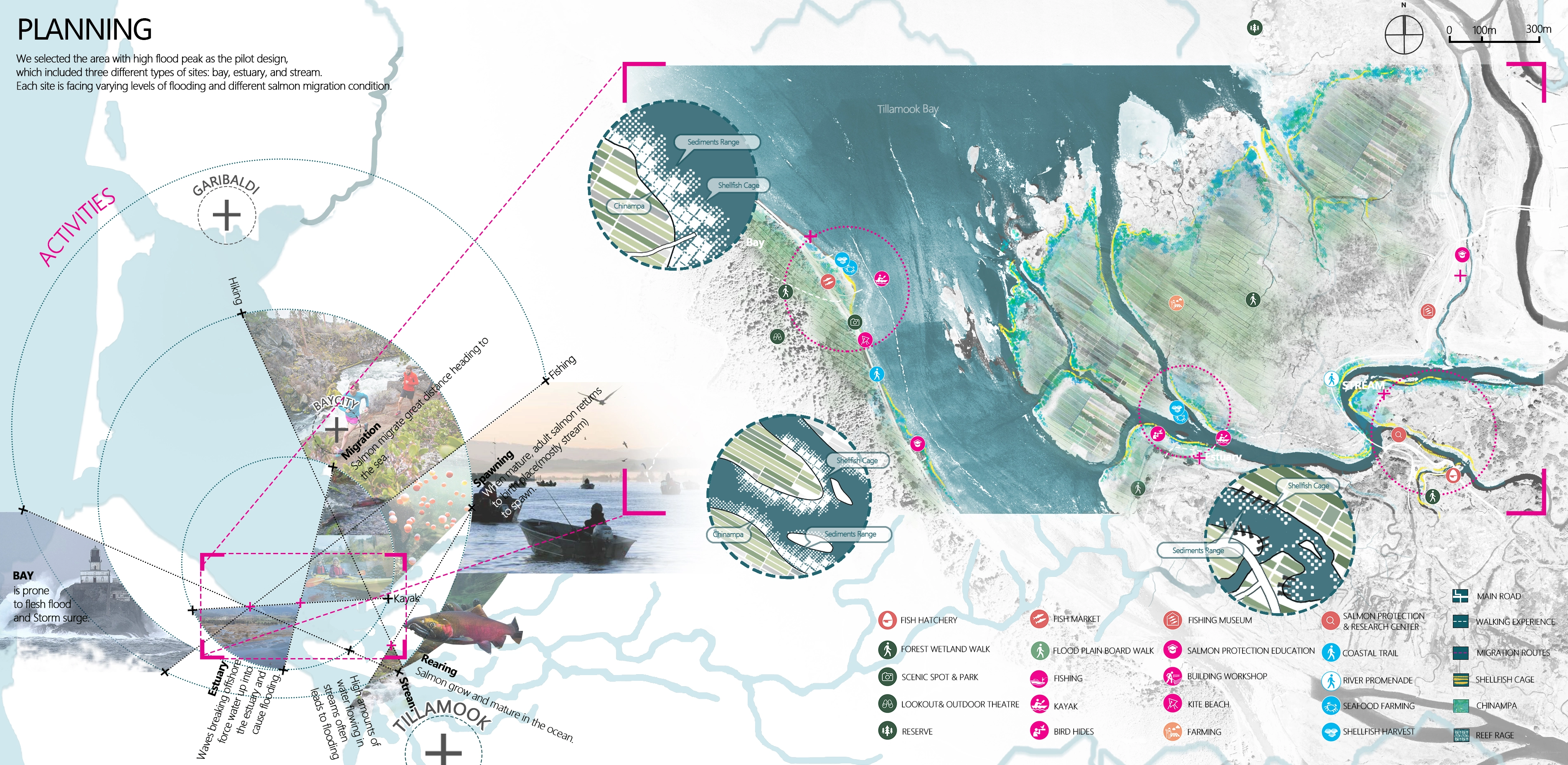
Ⅱ.Planning Area:
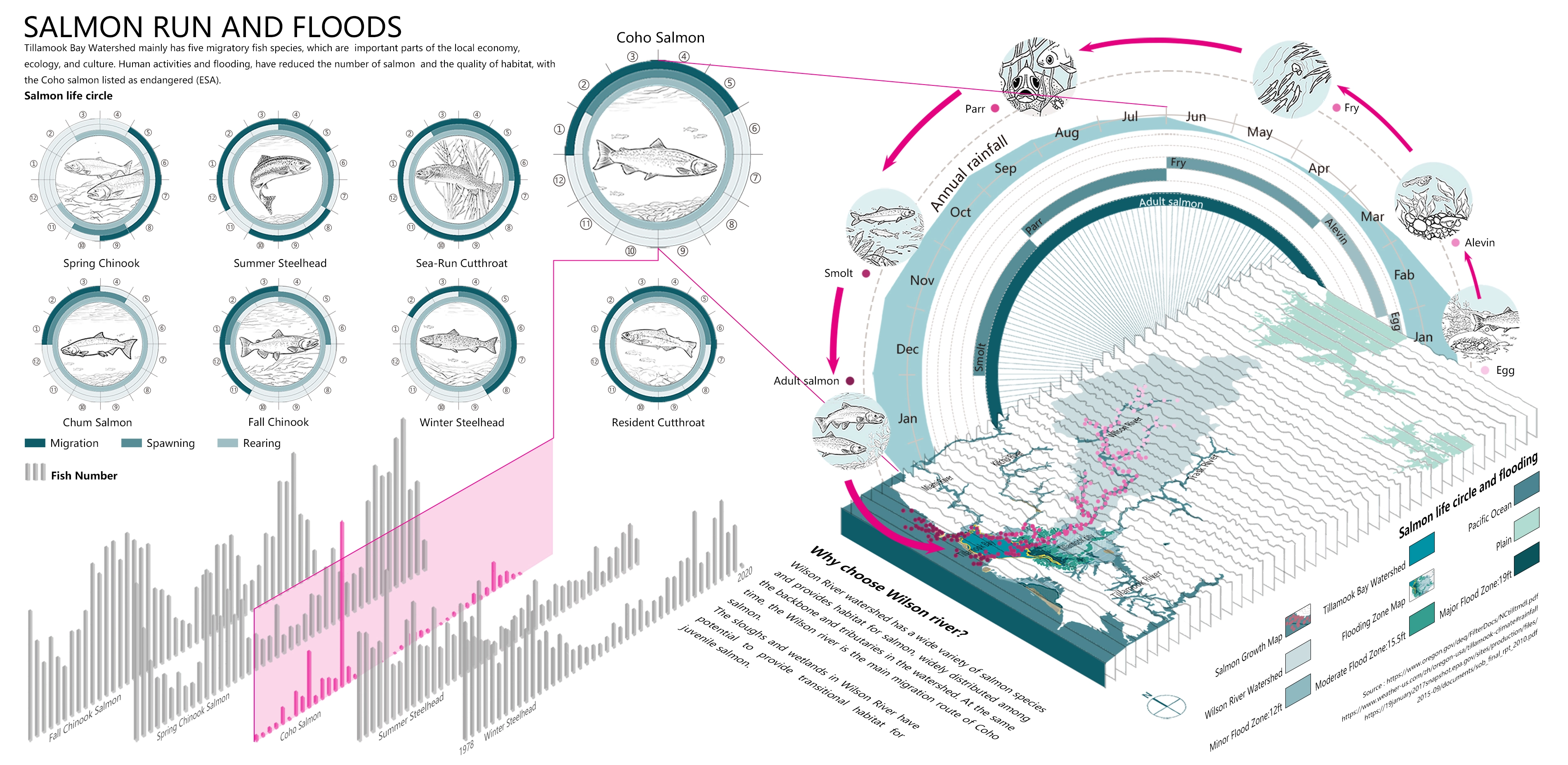
The Tillamook Bay Watershed lies near the northwest corner of Oregon on the western side of the Coast Range Mountains. The towns of Tillamook, Bay City, and Garibaldi locates near or on the shore of the Bay. It is a typical flood-prone zone in Oregon with five lively rivers passing through.
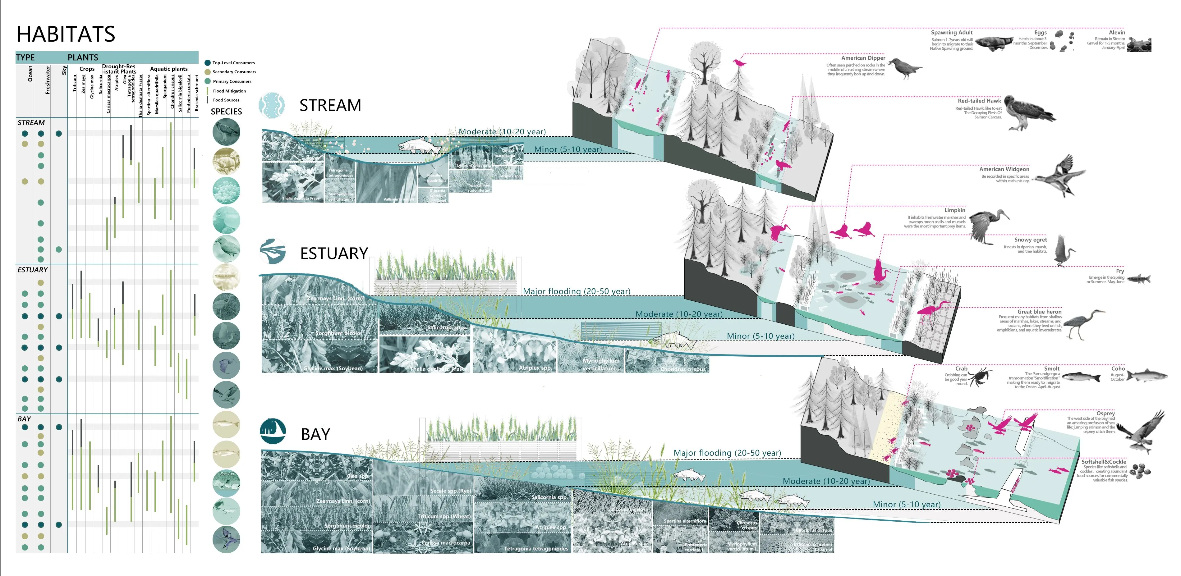
The Tillamook Bay Watershed has five migratory fish species: Coho salmon, Chinook salmon, salmon, rainbow trout, and cutthroat fish, which are important parts of the local economy, ecology, and culture. Human activities and flooding, among other factors, have reduced the number of salmon in the Tillamook Bay Watershed and the quality of habitat for other estuarine creatures, with Coho declining the fastest to the point of extinction and listed as endangered. Wilson River of Tillamook Bay Watershed, as one of the five tributaries of the basin, is affected by floods and is also the main migration route of salmon, so we select Wilson River as the main area for this pilot project.
Ⅲ.Analysis: Flood is a natural process and is a double-edged sword to the local environment. Flood management can reduce the hazards and damage of flooding while at the same time hindering the beneficial effects of flooding on the natural resources of the system, for example, for the promotion of the salmon life cycle. When a river is healthier and more connected, it will be more resilient to natural events, especially floods.
An analysis of historical data within the region suggests that the Tillamook people have a long history of fighting floods, such as building barriers (embankments, bridges, culverts, dams, etc.), however, these infrastructures hinder local fish migration. By stacking the peak flood levels with the salmon population changes, we found that:
1. The flood area produced by moderate flooding favors salmon growth. The flood plains provide habitats for salmon in the form of seasonal wetlands, temporary tributaries, off-river ponds, depressions, spillways, and seasonal estuarine basins. Natural flood plains can also store floods in wetlands to control flooding in certain areas.
2. When the flood exceeds its maximum peak, it not only destroys the human living environment, but its quick water flow washes away the fish eggs and reduces the salmon population.
3. Salmon can adapt to seasonal flooding. High water levels can be a cohort of migration or an opportunity to enter and develop different habitats. The flood created new channels and a range of new habitats while eliminating other decaying habitats. And it cleaned the matrix and changed the species composition of the riparian communities.
To sum up, from the social and economic point of view, the flood brings losses. From an ecological perspective, flooding is an integral part of the salmon life cycle. How to balance the relationship between the two aspects by landscape approach is our original intention to choose this subject, so that reducing flood damage and protecting salmon habitat to achieve a more resilient floodplain ecosystem.
So we conducted a further analysis of the site from the following three aspects.
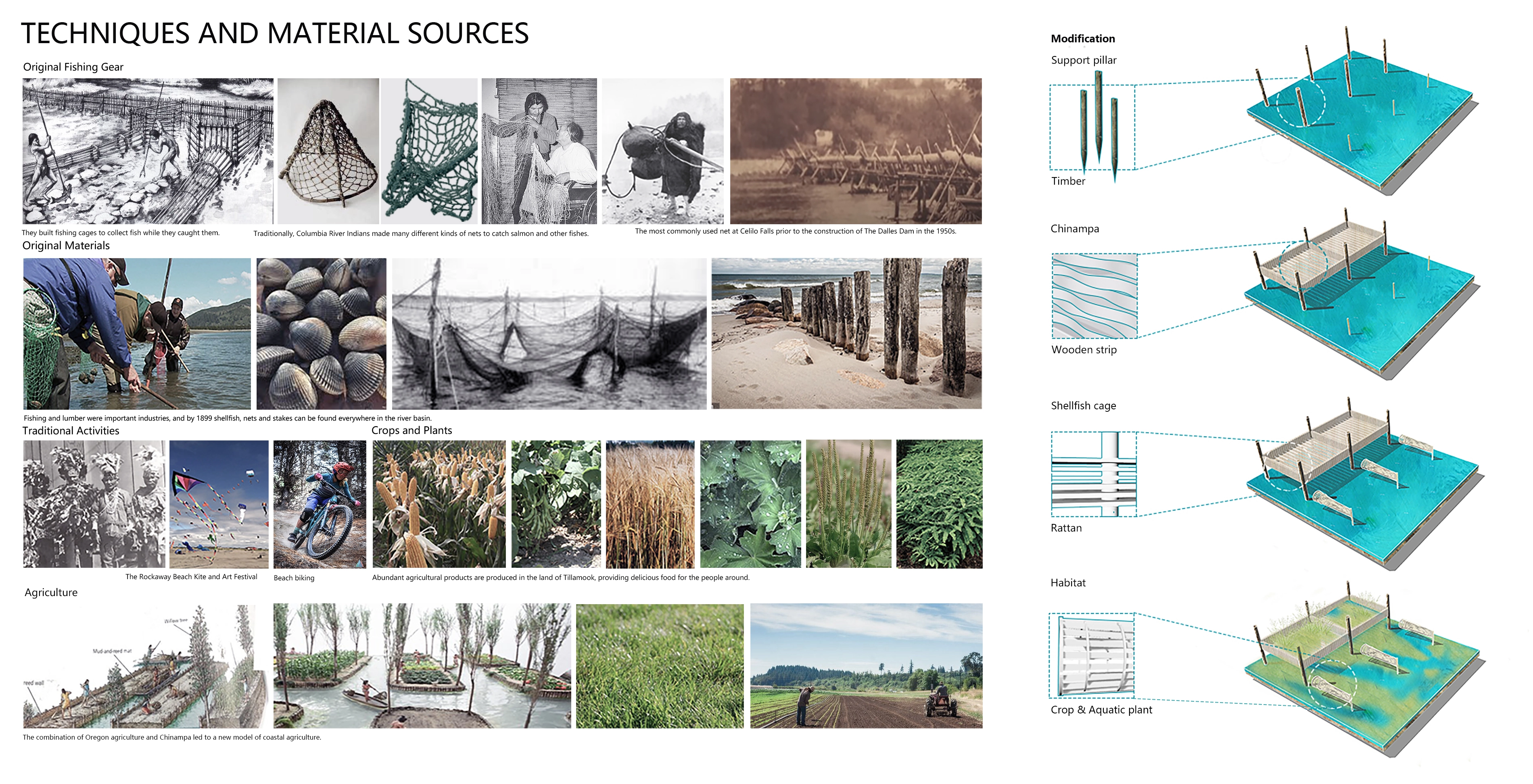
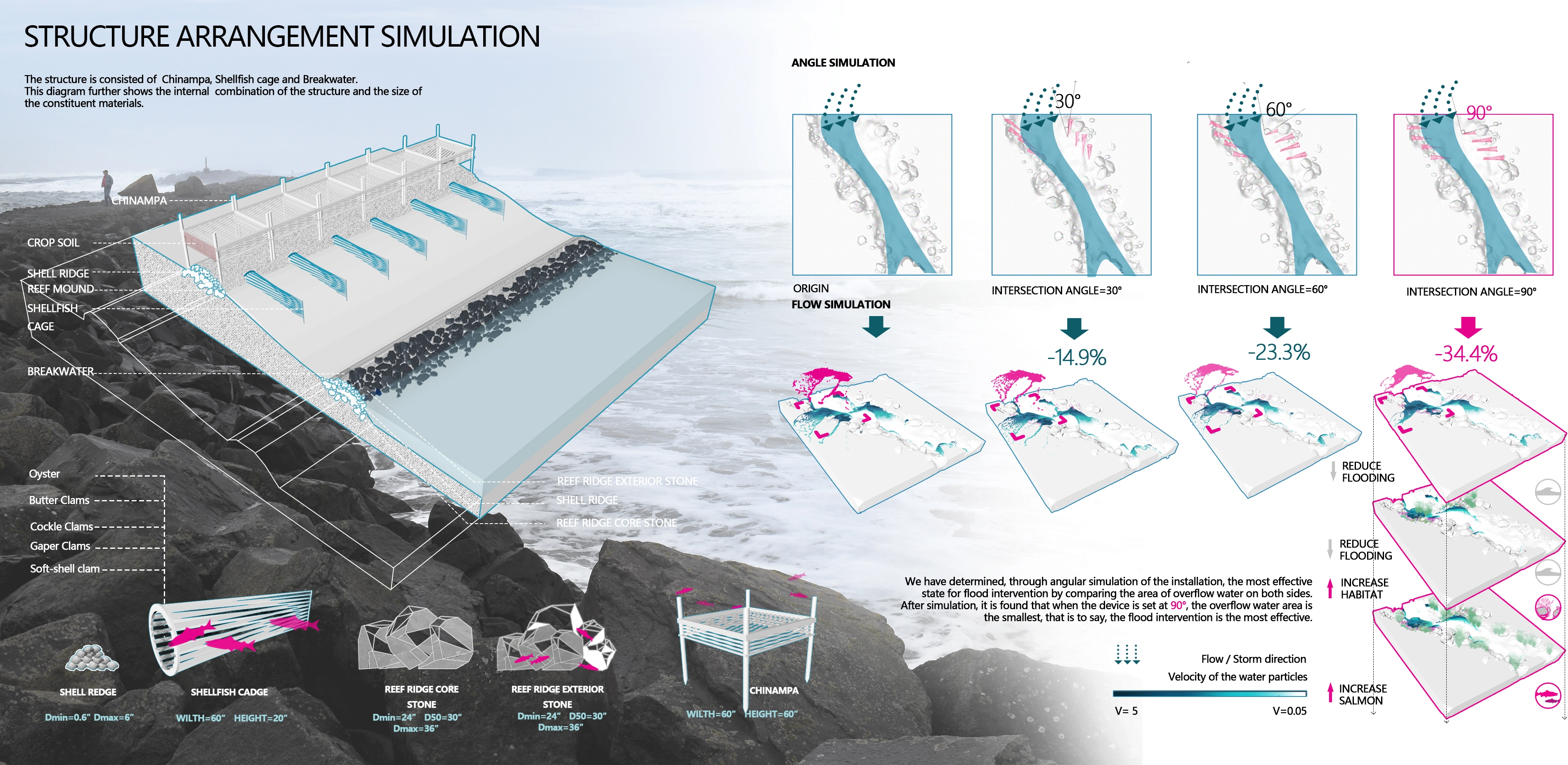
Culture and Community: The cultural and commercial value of salmon production is closely related to the lives of the local residents. Dig deep into the local farming history and the residents daily living habits of recreational activities, economic industries, as well as locally available materials and techniques, we found that the matured technology of local shellfish breeding and chinampa farming have good application prospects. After modification, to form useful structures for managing floods and create habits with local memory characteristics.
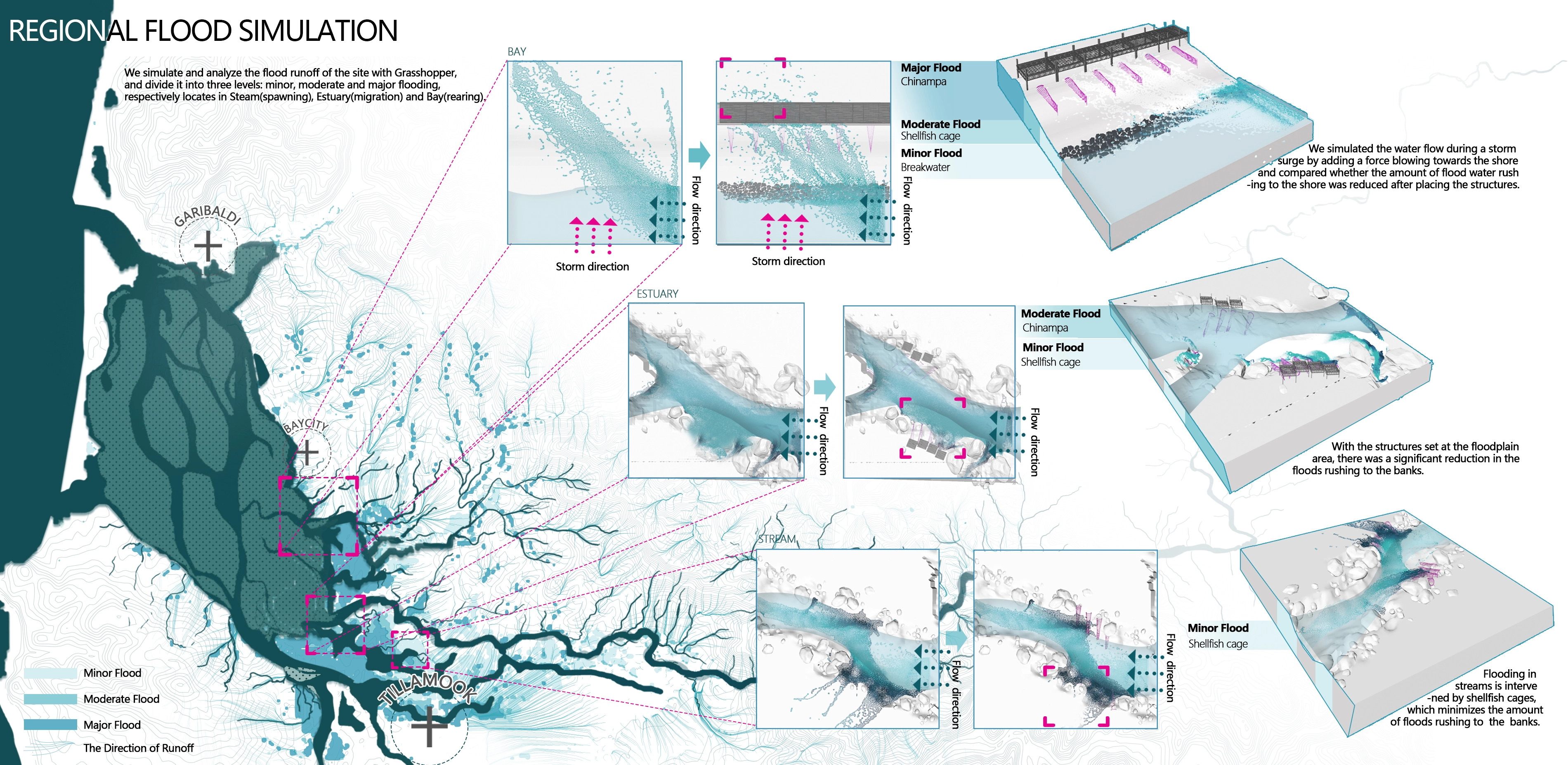
Flood reduction: Through grasshopper runoff simulation, we determine the influence range of floods of different intensity as the basis for the later flood reduction strategy. Hydrodynamic simulations were carried out with Realflow model to determine the optimal arrangement and appropriate dimensions of structures to form habitat, slow flow, and reduce flood peak and flow of flooding to downstream communities.
Salmon migration: We identified three types of salmon migration: bays, estuaries, and upstream streams. We create different types of habitat by analyzing the needs of salmon migration during various periods while increasing the habitat complexity and ecological stability of the riparian and coastal zones.
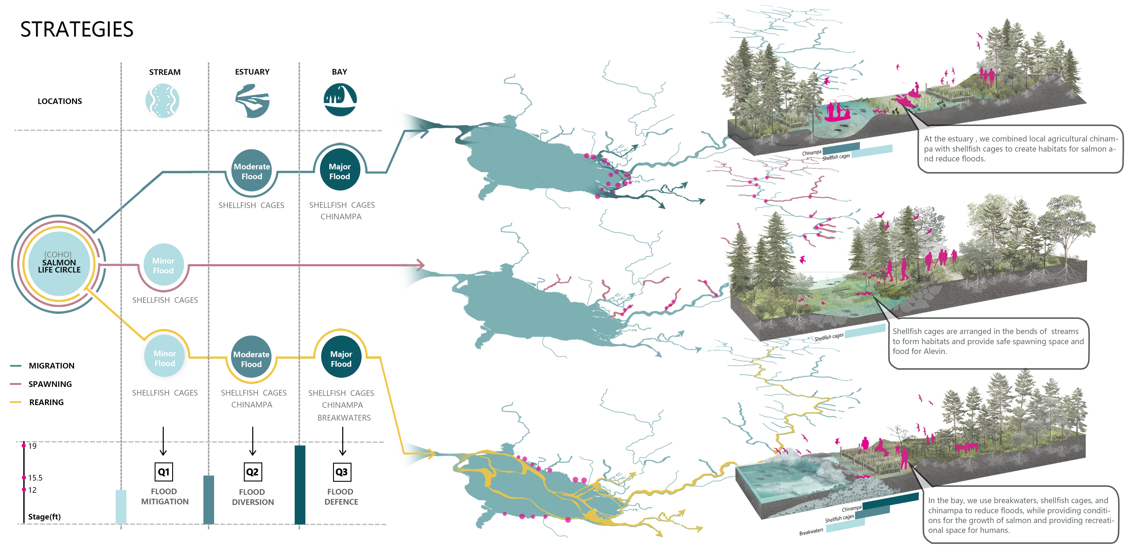
Ⅳ.Strategy:
After the above analysis, we formed our final strategy. The different periods of salmon run correspond to different locations in the watershed, and the different locations are exposed to different levels of flood risk, which intertwine to form our tailored local solution strategy.
Instead of traditional prevention-led approaches in flooding management designs, this experimental project attempts to seek a symbiosis way of living with potential flooding and salmon habitat conservation.
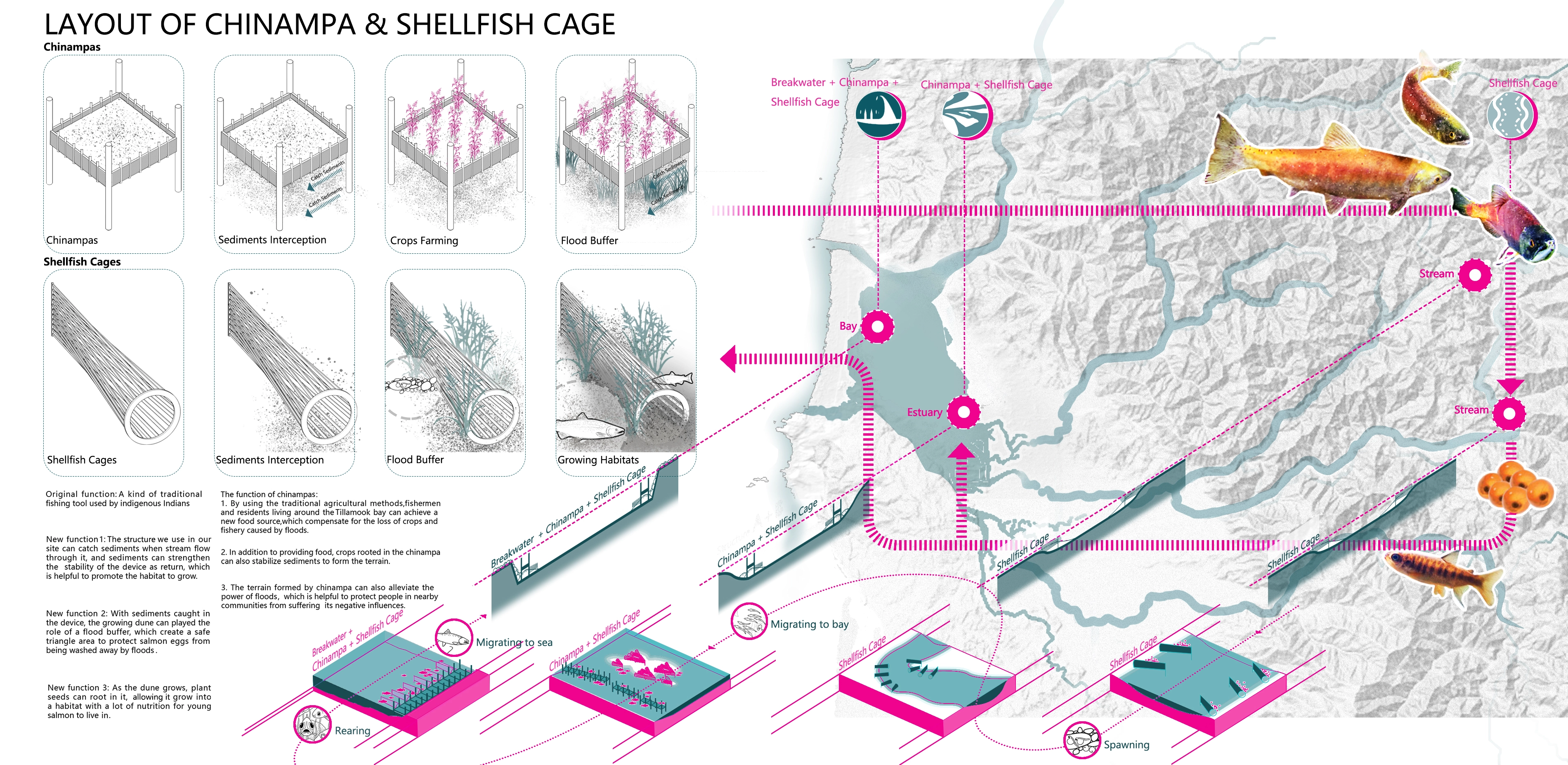
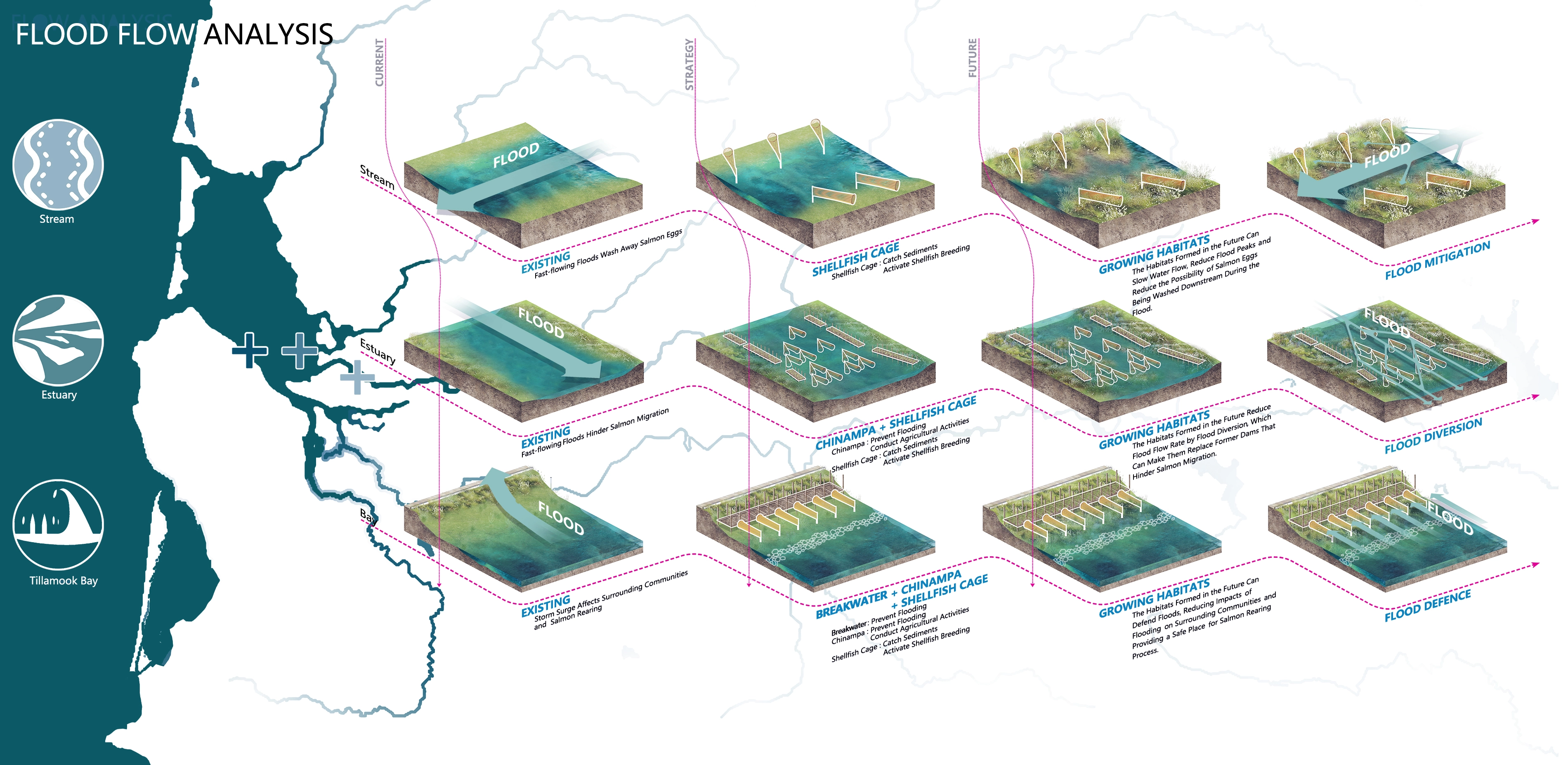
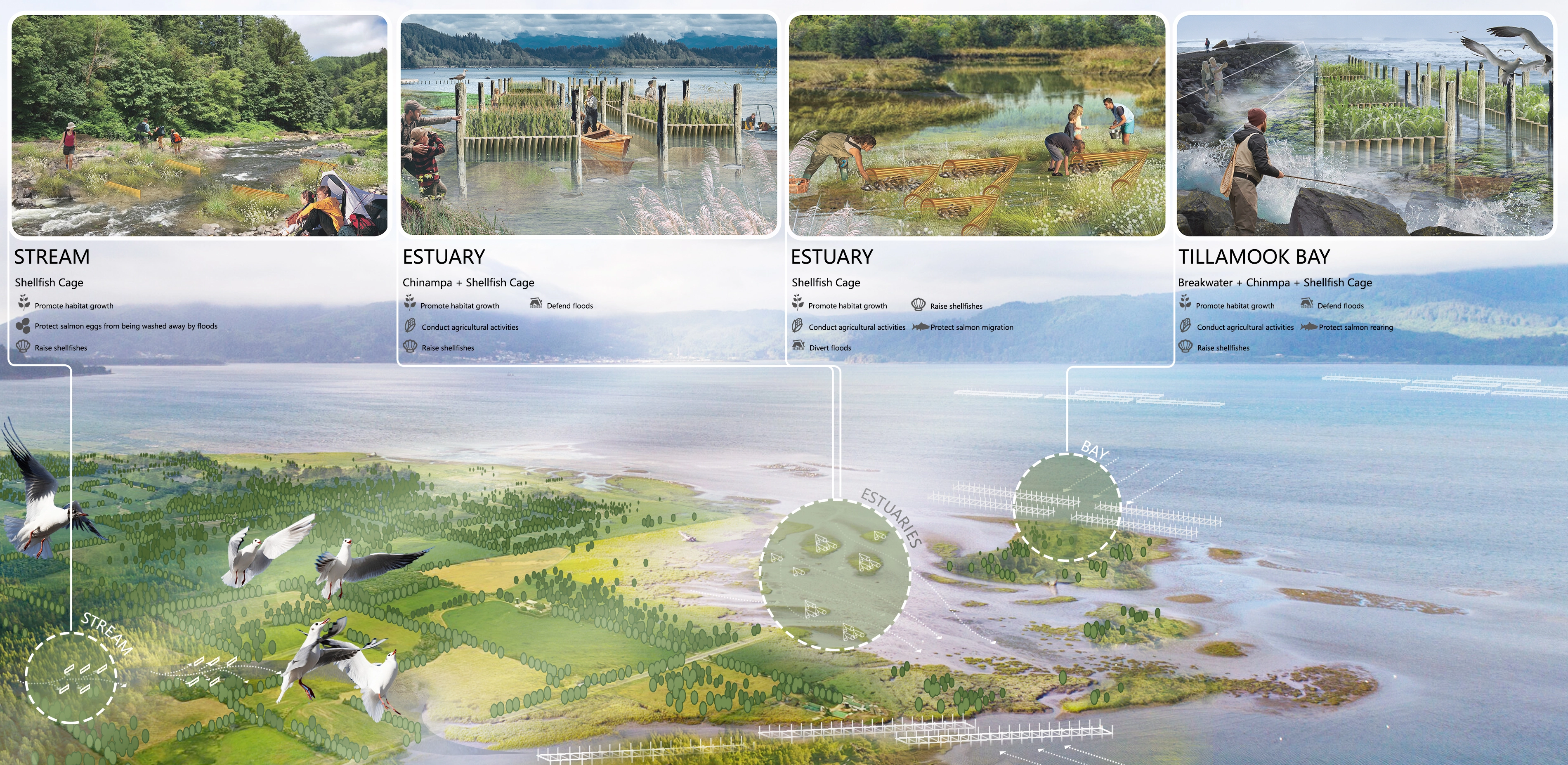
We simulate and analyze the flood runoff of the site with Grasshopper, and divide it into three levels: minor, moderate, and major flooding, respectively locates in Steam(spawning), Estuary(migration), and Bay(rearing). And here are three actions for each type of habitats:
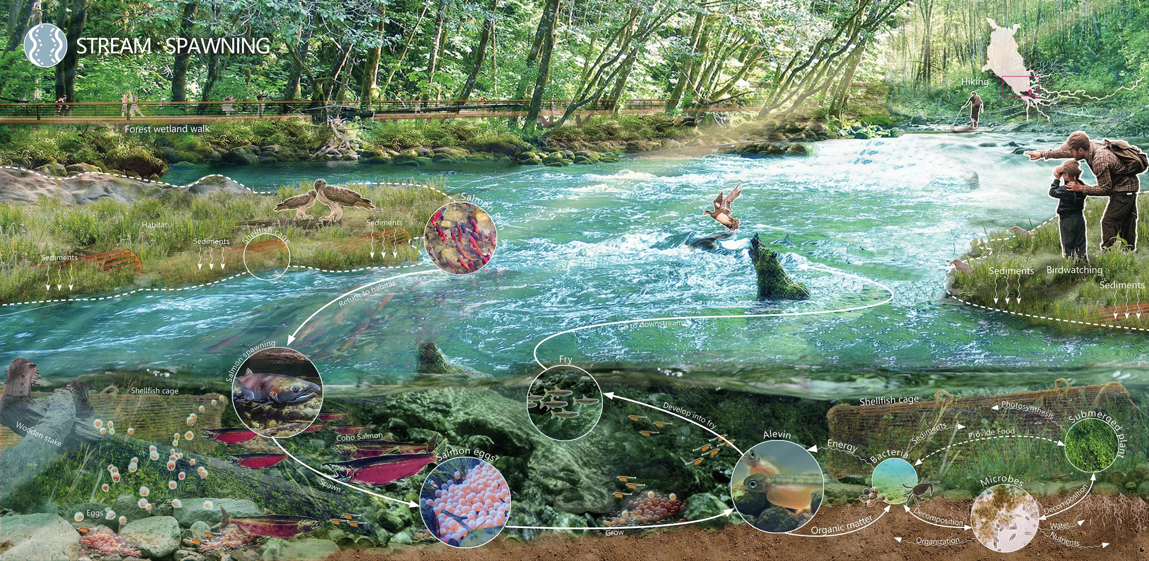
1. Stream:
1)By placing shellfish cages on both sides of the stream floodplain, these structures can slow water flow, reduce flood peaks, and reduce its flow to the downstream communities.
2)The setting of the shellfish cage increased the complexity of the habitat, eventually allowing it to improve spawning gravel and retain organic content, thus reducing the chances of salmon being preyed on and the possibility of juveniles being washed downstream during the flood.
3)Several hiking trails were set up along the stream for travelers to explore.
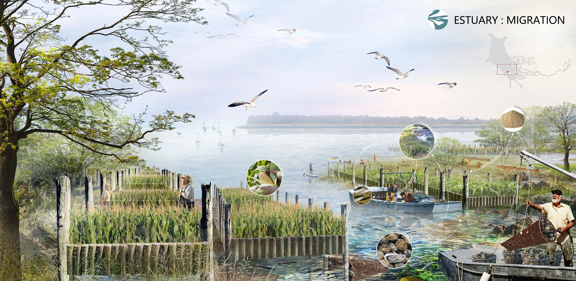
2.Estuary
1)We use Chinampa and shellfish Cages in the Estuary delta area to reduce the flood flow rate and conduct flood diversion.
2)Salmon habitats will replace former dams to facilitate salmon migration.
3) Update the way of farming in local communities and activate the shellfish breeding industry.
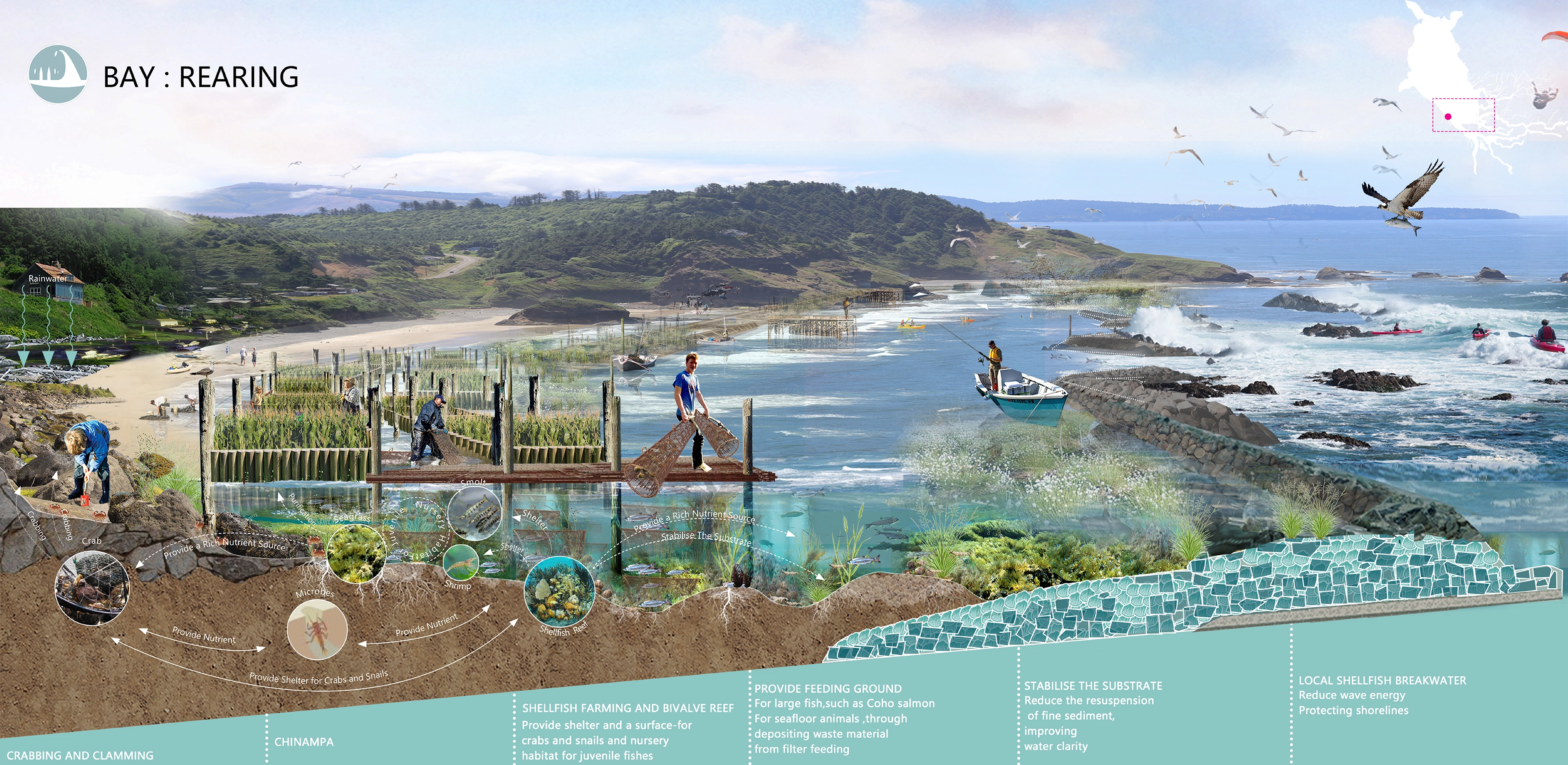
3.Bay
1)We arrange Chinampa, shellfish cage, and breakwater in the bay area to reduce the flood wave energy.
2)The structures provides biological growth surfaces. They become the Coho feeding ground, supplies a marine-rich source of nutrients and eventually form habitats.
3)Structures combined with beach wooden walkways provide spaces for shellfish fishing activities and various marine fishing activities.
Ⅴ.Prospect
We hope to achieve flood reduction through habitat network establishment while integrating local activities to form a symbiotic system. To solving the long-plagued flood and salmon conflicts, Tillamook bay will eventually rebuild its "habitat connectivity" and reconnect more historic habitats. Our strategy promotes regional ecological resilience and reduces long-term flood problems while reinvigorating the local community and stimulating local economic development.
-
- Chenliang Ma - consultant
- Xiaoyu Fu - consultant
- Yixin Zhang - consultant
-
- Thalia dealbata Fraser
- Spartina alterniflora
- Myriophyllum verticillatum
- Vallisneria natans
- Marsilea quadrifolia
- Lythrum salicaria
- Carissa macrocarpa
- Salicornia
- Triticum aestivum
- Zea mays Linn.
- Sorghhum bicolor
- Glycine max
- Secale
Advertisement
Related Awards

Honor Award, Analysis & Planning
A Cultural Approach: The Fort Peck Tribes Hazard Mitigation Plan
In collaboration with the Fort Peck Assiniboine and Sioux Tribes, EPA, and FEMA, the Fort Peck Tribes Hazard Mitigation Plan (HMP) adopts a culturally responsive approach to hazard mitigation planning that features connection to place.

