.webp?language=en-US)


Bringing “Wetness” Back into the City
Lok Tim Chan, Student ASLA; Eric Zhenrui Mei, Student ASLA; Echo Xingjian Wang, Student ASLA
Situated in Barcelona where the climate is very dry, the students here tackled a problem with a thoughtful and incredibly site-specific analysis. The simplicity and sophistication of the design creates a fabric of the place they are proposing, expressed with analysis of local landmarks, textures, and imagery. It was a good example for designing for resilience, which is so important for the future.
Awards Jury
-
This project in its ambition to tackle complexities in the wicked problem of undesirable “dryness” that persists in Barcelona’s postindustrial waterfronts and urban fringes, aims to leverage the concept of “wetness” in its various interpretations and representations in order for reimagination of a better future by building resiliency, vitality and adaptability. Through rigorous cross-scale analytical processes to unfold the multidimensional existing qualities surrounding the site and its larger regional settings, a robust design inventory and strategy systems through typological investigation as well as articulated spatial manipulation, orientation are distilled to address issues at hand. In its essence, the design uses a diverse yet interconnected set of tools in an attempt to reach a level of comprehensivity that begins to resolve the different “dryness” in social, economic, ecological, geographical and infrastructural terms under a dynamic urban scale inclusive of a waterfront, riverscape and urban center. It is a design by inquiry, through research, realized via investigation, expanded from exploration and projection.
-
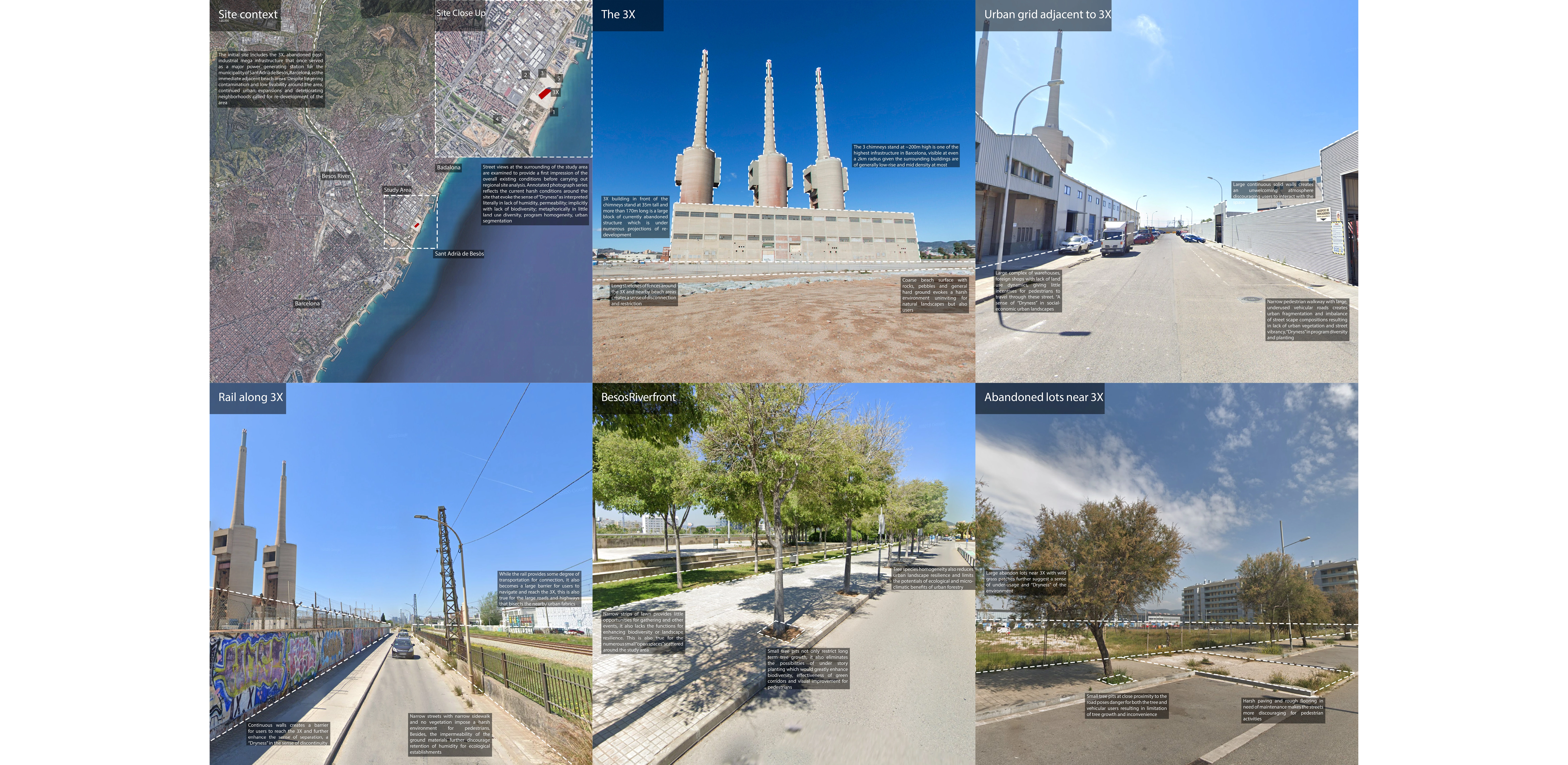
The Tres Xemeneies (Three Chimneys also known as 3X), a post-industrial infrastructure, is an intriguing artifact located in the much-neglected waterfront (and neighborhoods) of Sant Adrià de Besòs, Spain next to the famed River Besòs. It is a historic, monumental and iconic landmark that local communities related to deeply. With many local and international proposals suggesting different iterations of redevelopment concerning the structure, its immediate waterfront and inner urban fabrics, we too began to wonder an alternative future for the site, and its larger regional neighborhoods.
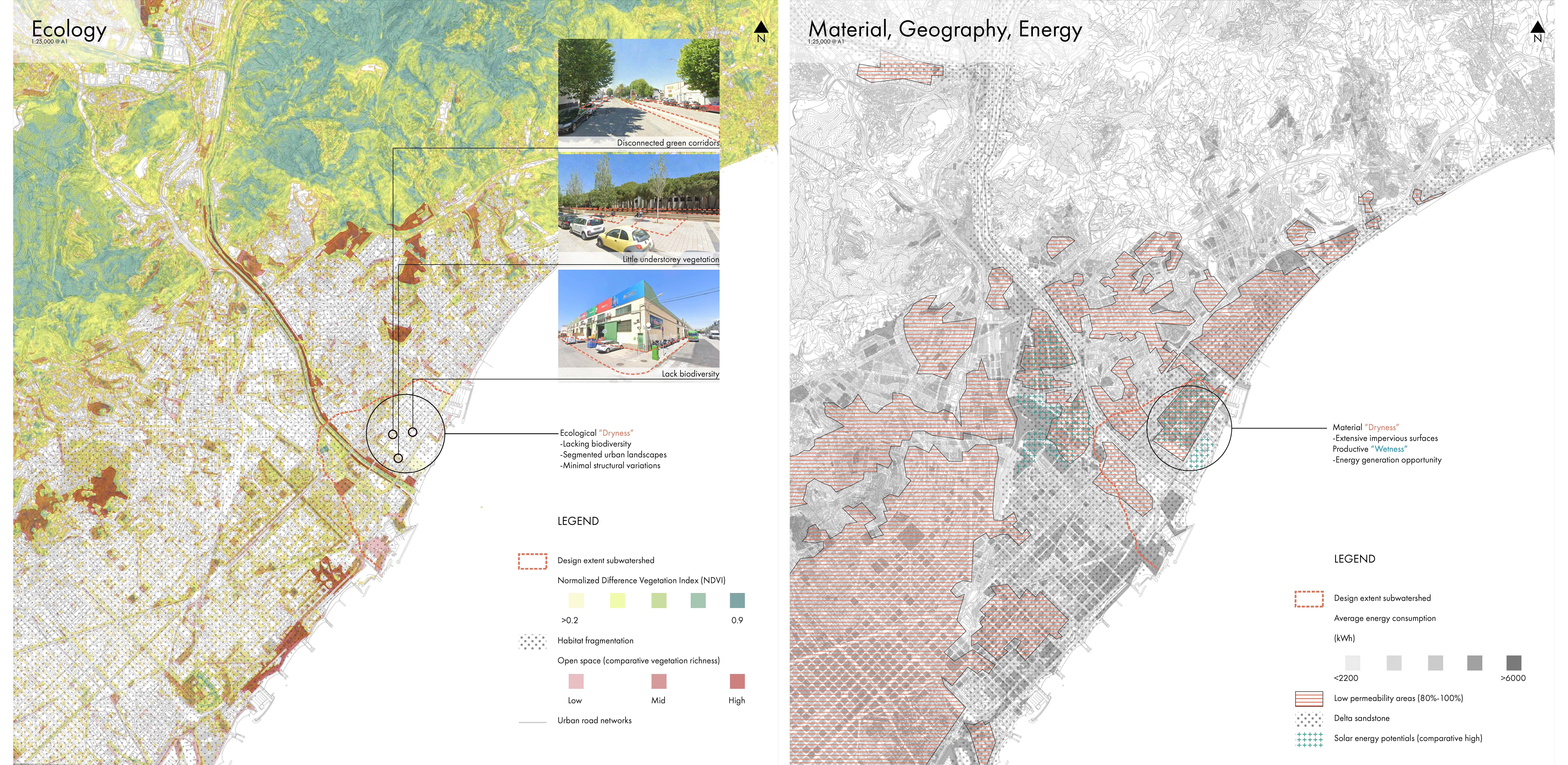
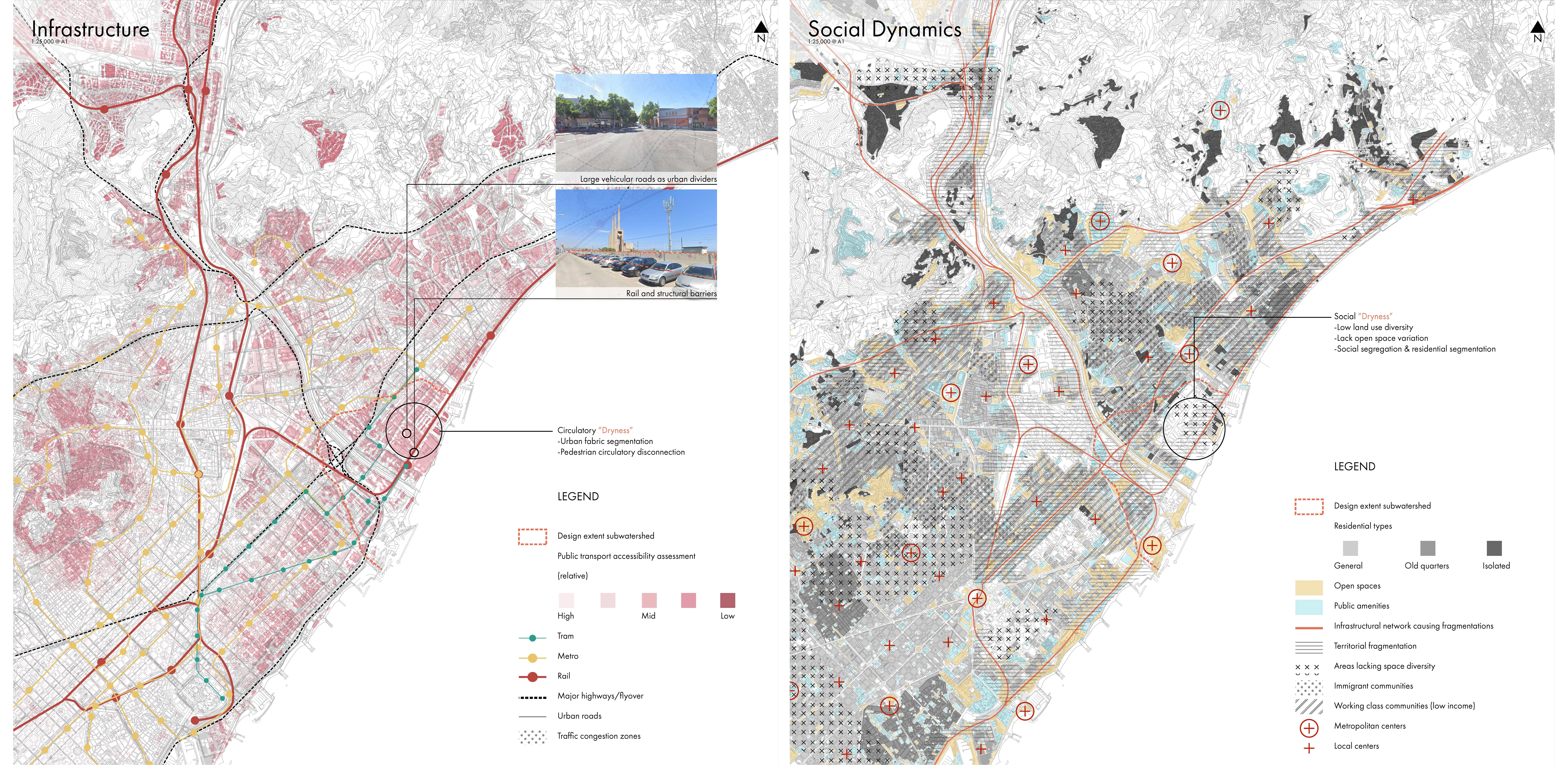
Our immediate reaction was to visit the site, the surrounding areas of the site, and while we couldn’t go in person, the best alternative was of course digital street views. And our first impression of the site was the sense of dryness it evoked, the harsh conditions, textures and environment, not innate natural Mediterranean dryness but those that are undesirable. Beyond the material and hydrological sense of dryness, we also saw dryness in other ways, such as the crude streetscapes, lack of vegetation and impermeability. Dryness is social aspects of lacking land use diversity and urban vibrancy. Dryness in social and ecological segmentations and disconnections. Dryness in low biodiversity and underusage.
With this first impression, this intuition of the study area, we moved into a comprehensive regional analysis exercise in order to identified, investigate and visualization what sort of dryness, wetness exist in the districts, what are their relationships and how do they communicate with each other thereby creating the scenes that we see through street views.
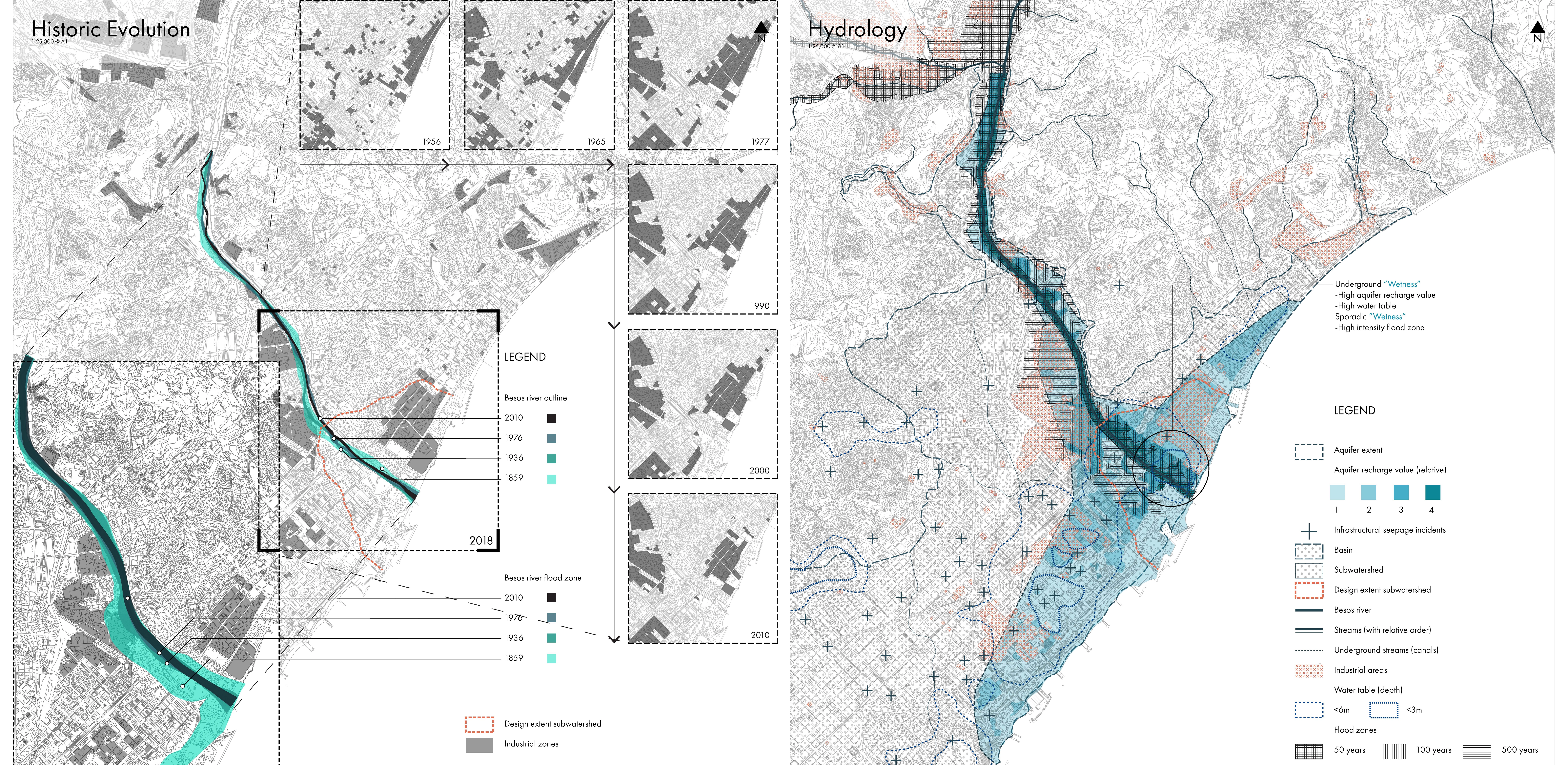
From historic evolution we began to understand how some aspects of dryness came about, with industrial expansion and urban densification, the Besos River once flowing freely bring moisture to the land was controlled and limited. Yet, from the hydrological review, the traces of its past extents remain, simply hidden underground. Through hydrological mapping and investigation, we see areas of high water table levels and recharge that reflects the underground wetness, an opportunity that we can leverage and amplify. As we move on to ecological aspects of the region, it is clear that dryness continues in forms beyond lack of water at the surface, but the lack of biodiversity and vegetation density is also evident as we realized from the annotated photographs. Infrastructure analysis further identified the extent of social dryness in urban disconnections but also correlates to the lack of continuous vegetation networks. Large highways, rail and road networks limit the spread of planting, creates discontinuities for local communities as well as lowering mobility. From the social perspective it is also evident dryness exists in the form of land use homogeneity which leads to low social vitality and vigor as there a little opportunities or incentive for gathering, interactions and events. In terms of materiality, it is clear the large extent of impermeable surfaces also contributes to the overall sense of harshness.
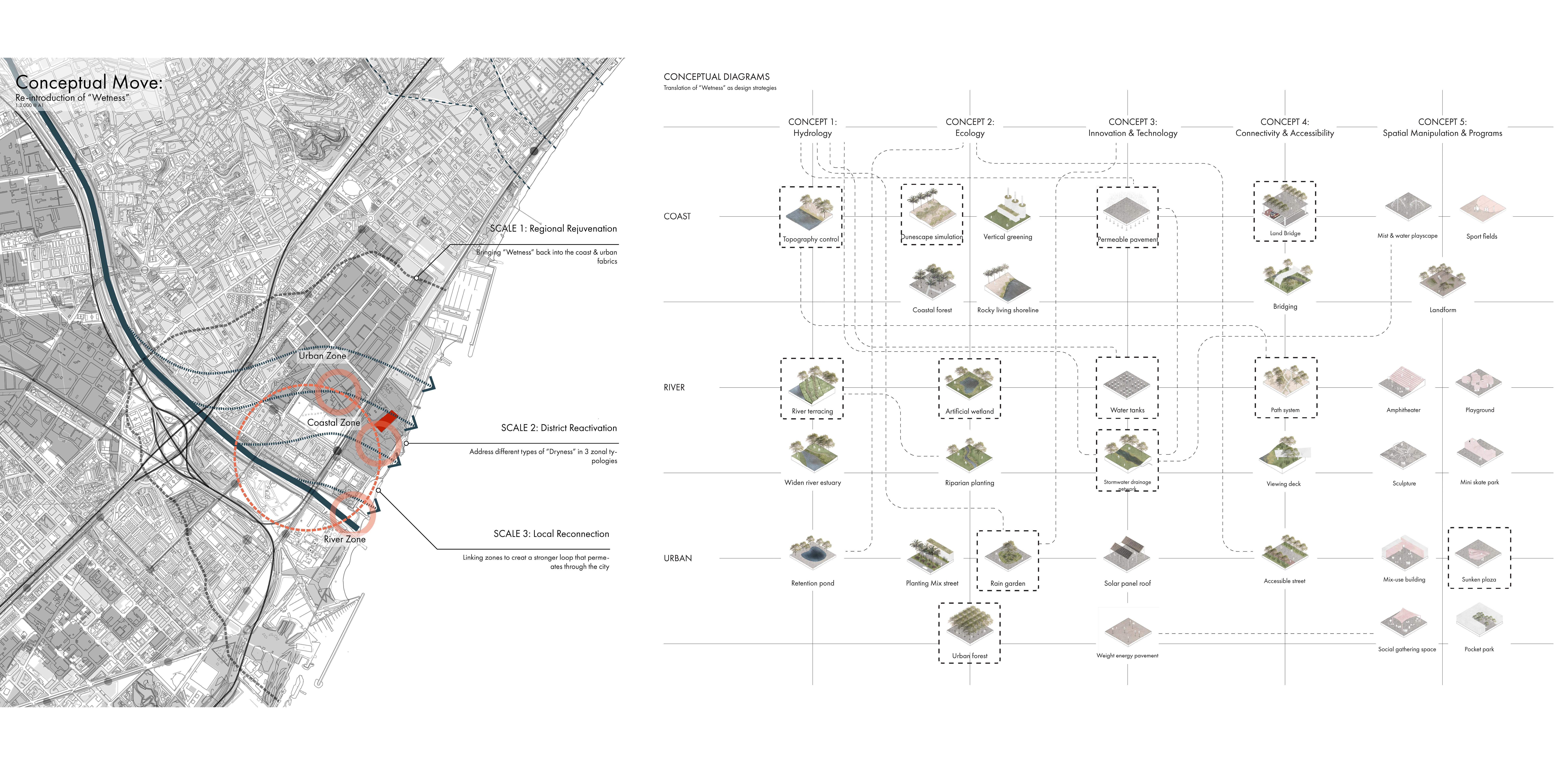
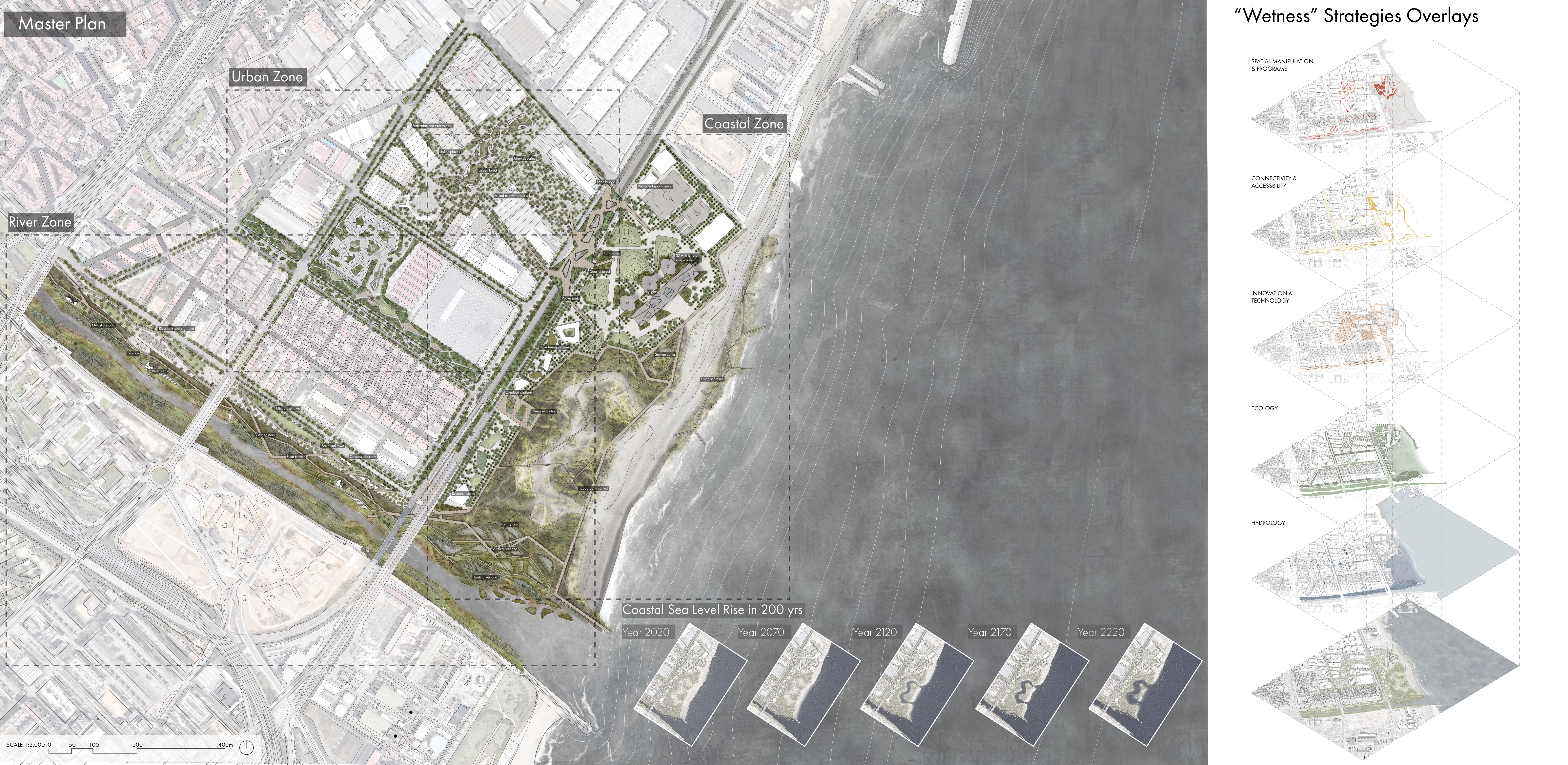
By understanding the complexity of the issue at hand, this wicked problem of “dryness” in its multi form penetrating various dimensions, we began to explore how may design interventions, a corresponding “wetness” begin to address these challenges that stretches far beyond the 3X. By looking at the re-introduction of “wetness” as our primary move across scales, from the regional scale we identified 3 major zonal typologies, the coast, the river and urban fabric to imagine transformations that reconnects these zones to rejuvenate the larger neighborhood. This was further detailed in spatial extent and we started brainstorming some particular interventions to address the different forms of dryness, from urban forests to dunes simulation and river terracing. After these initial design processes, systems of strategies were drawn out that would become our design inventories for a holistic and comprehensive approach to address the different types of “dryness”. 5 strategies of “wetness” are classified with some address literal dryness while others on implicit, metaphorical dryness such as the social dryness.
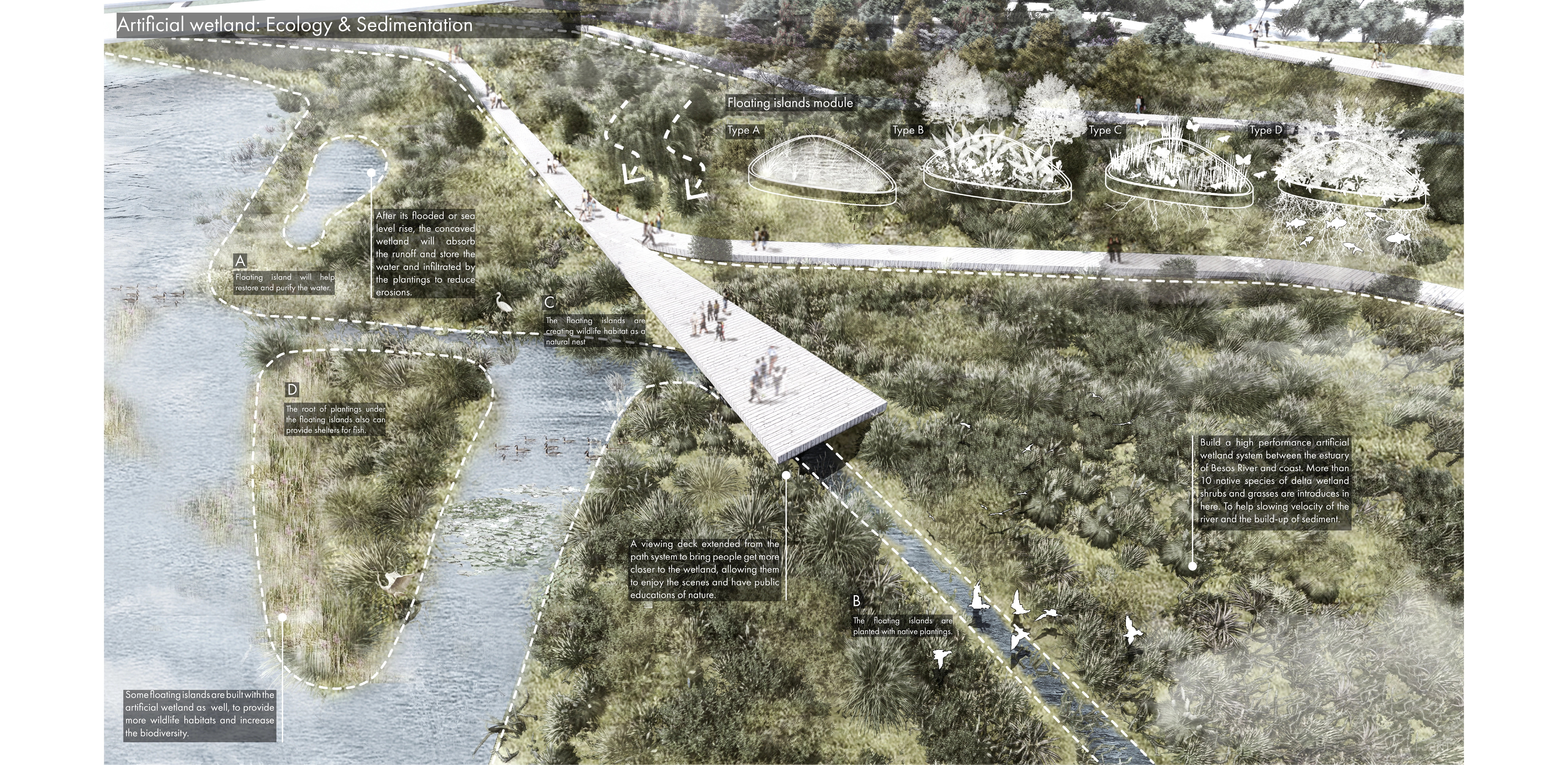
From these typologies there is a level of hierarchy in which some modules are more extensive and instrumental to the overall design of the region such as the dunes simulation, the networks of water tanks and stormwater drainage system that connects the 3 zones, river terracing and sunken plazas that has a diverse set of performative qualities serving as retention ponds but also Mediterranean rain gardens with vegetation. These became the building blocks, the assemblage of the design that begins to build resiliency with anticipation of flooding and sea level rise from climate change but also promote sustainable development that active integrates and enhances local biodiversity while at the same time provide a robust site programming that enables diversity and inclusion.
These systems of typologies are then strategically assembled in the regional site and through the masterplan, visualize the implication of the regional implementation
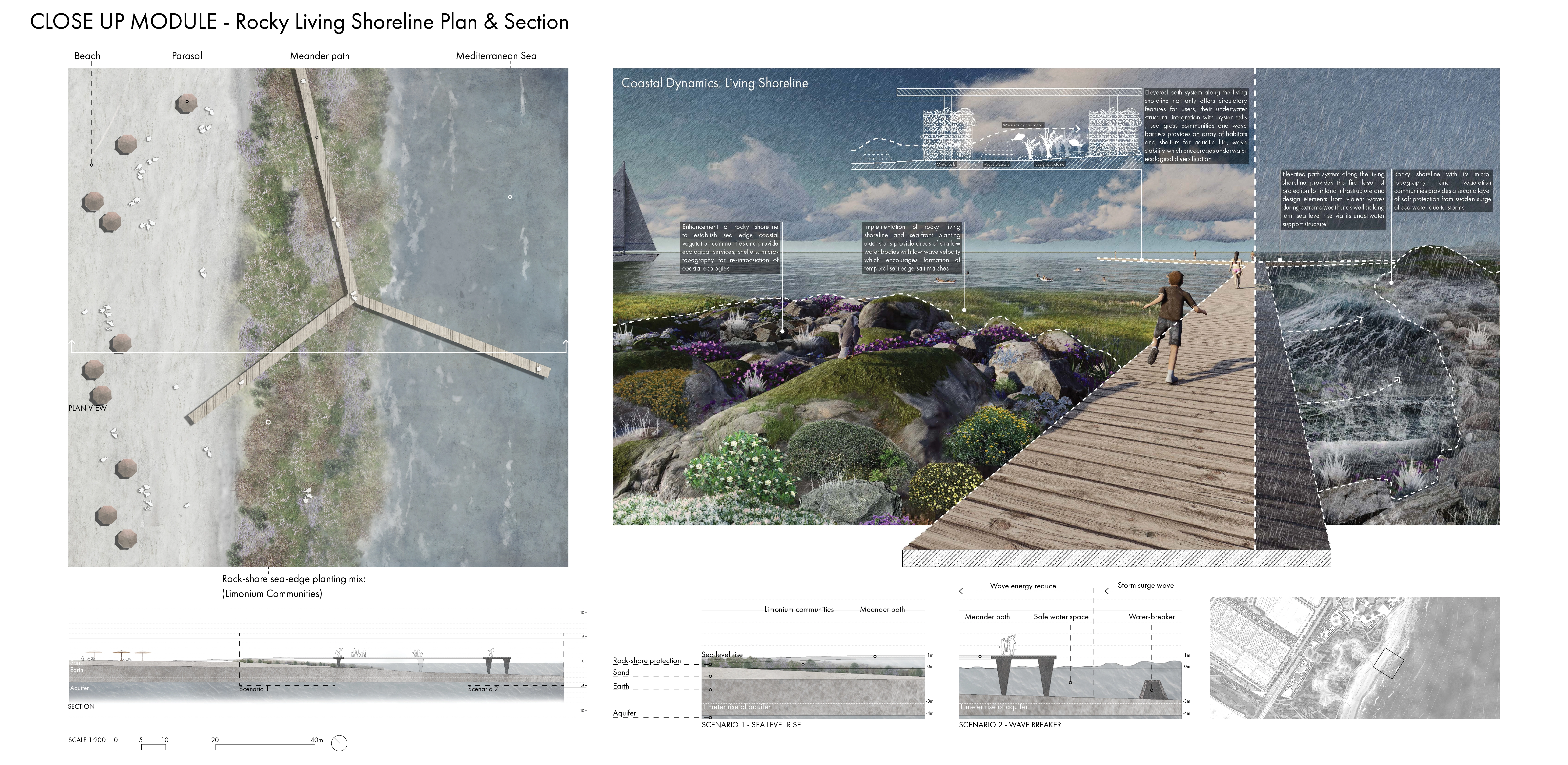
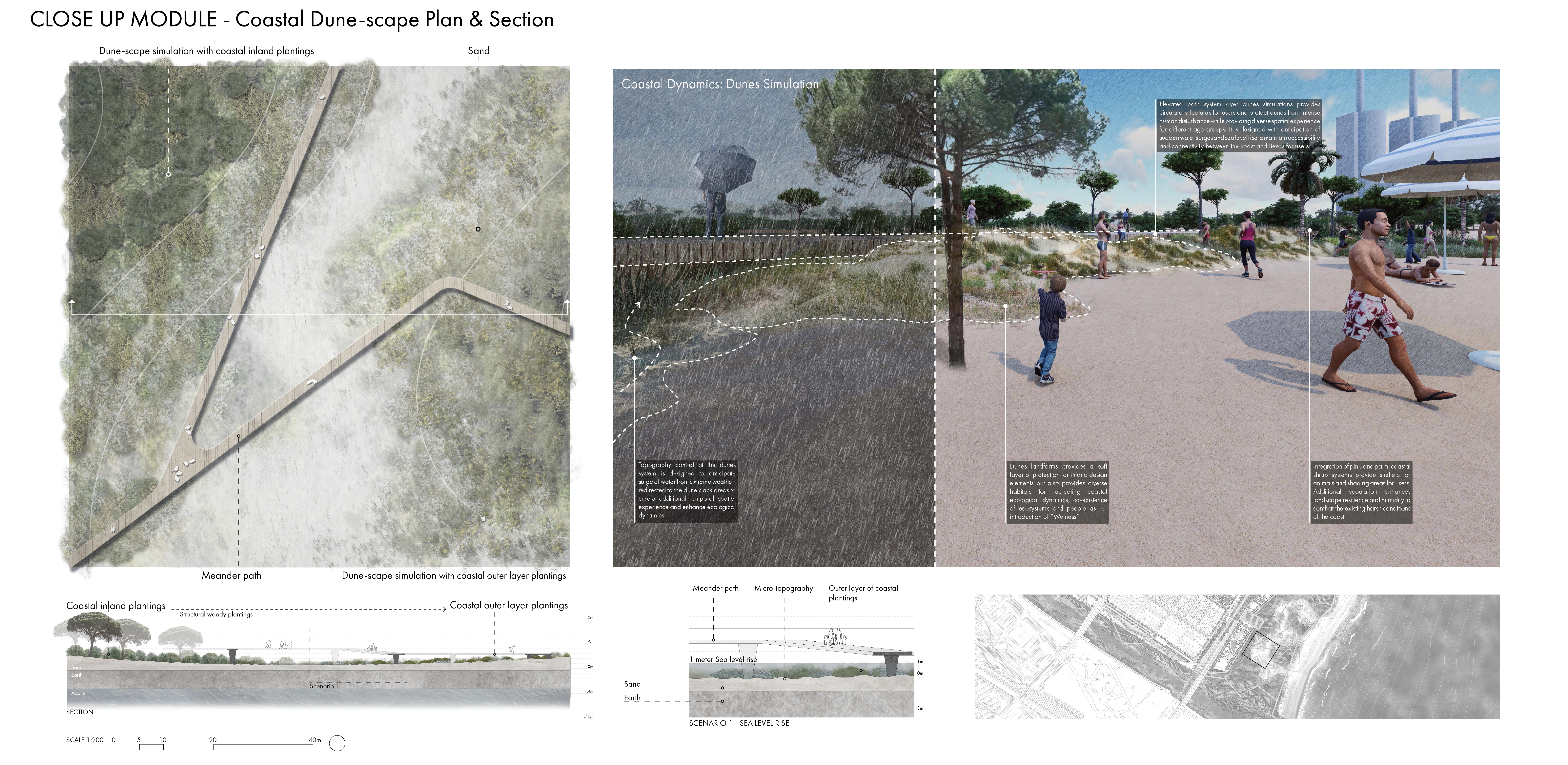
From the coastal zone we see a large extent of dunes simulation which are artificial dunes with topography control, but also a stretch of living shoreline to protect the 3X and inland interventions from storm waves as well as long-term sea-level rise.
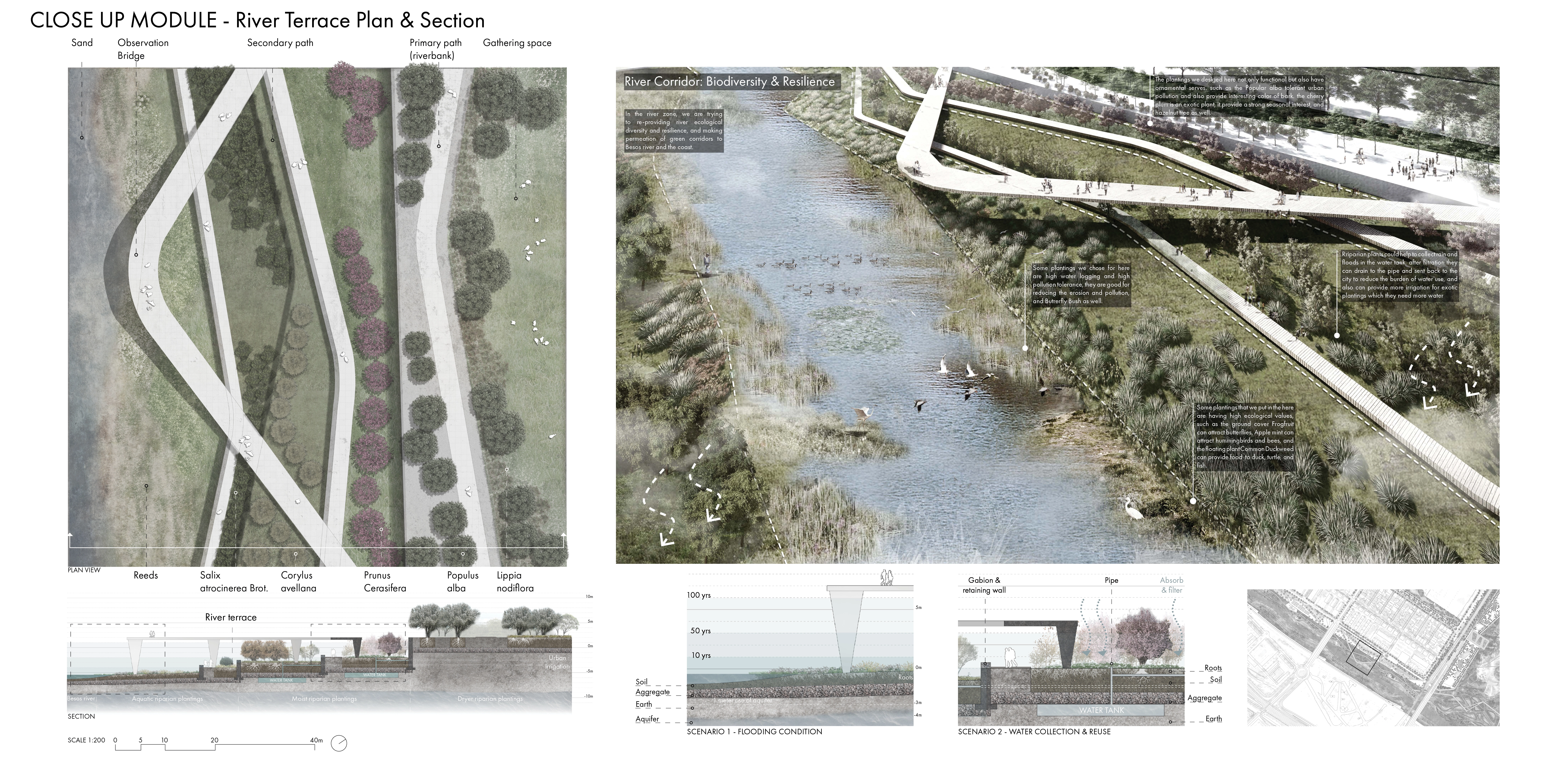
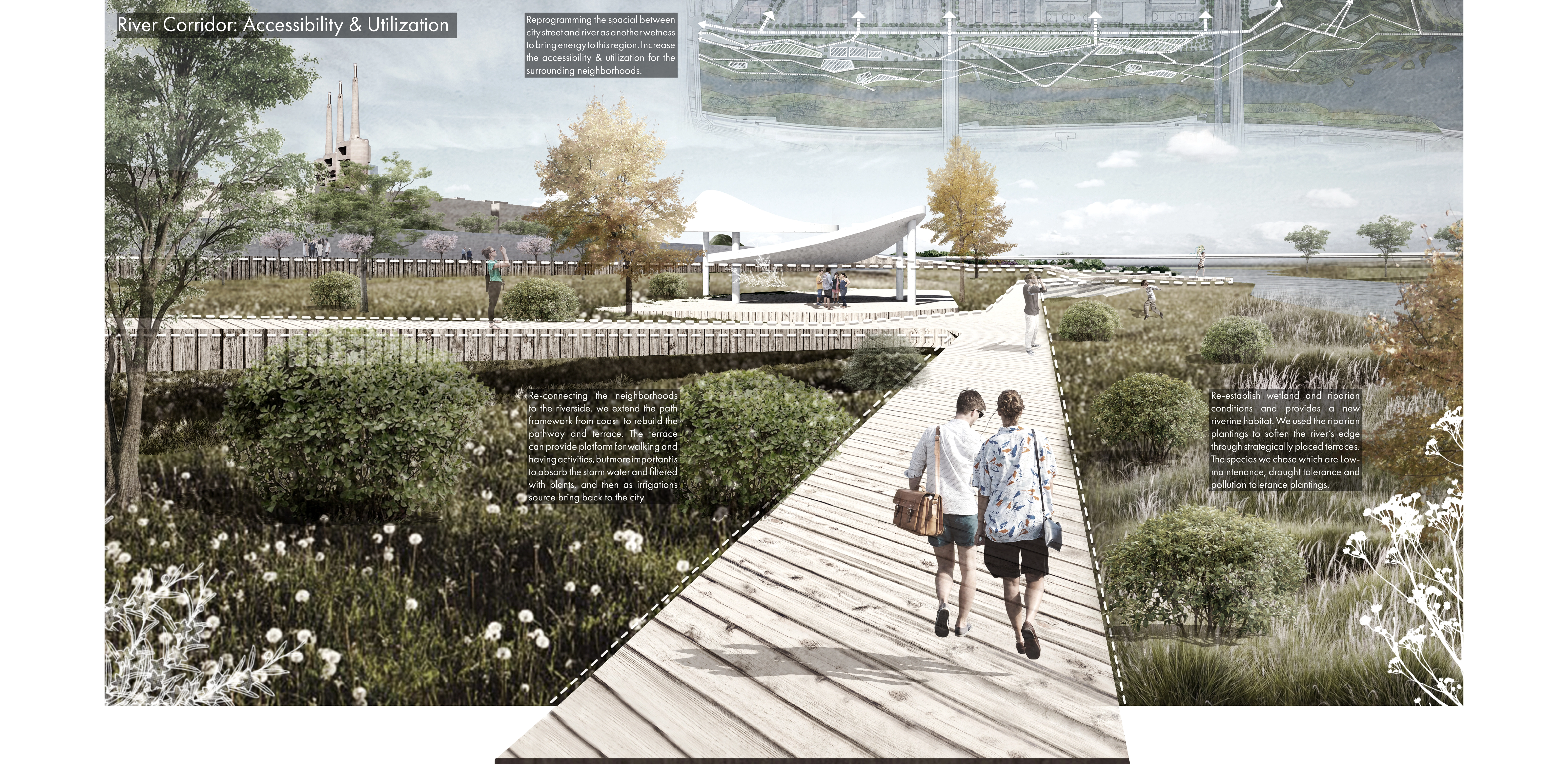
In the river zone the river terrace and artificial wetlands enhance the ecological services of the Besos river but also is designed to anticipate sudden flash floods with water tank systems and stormwater pipe networks connections that can redistribute the stormwater to feed the urban forests.
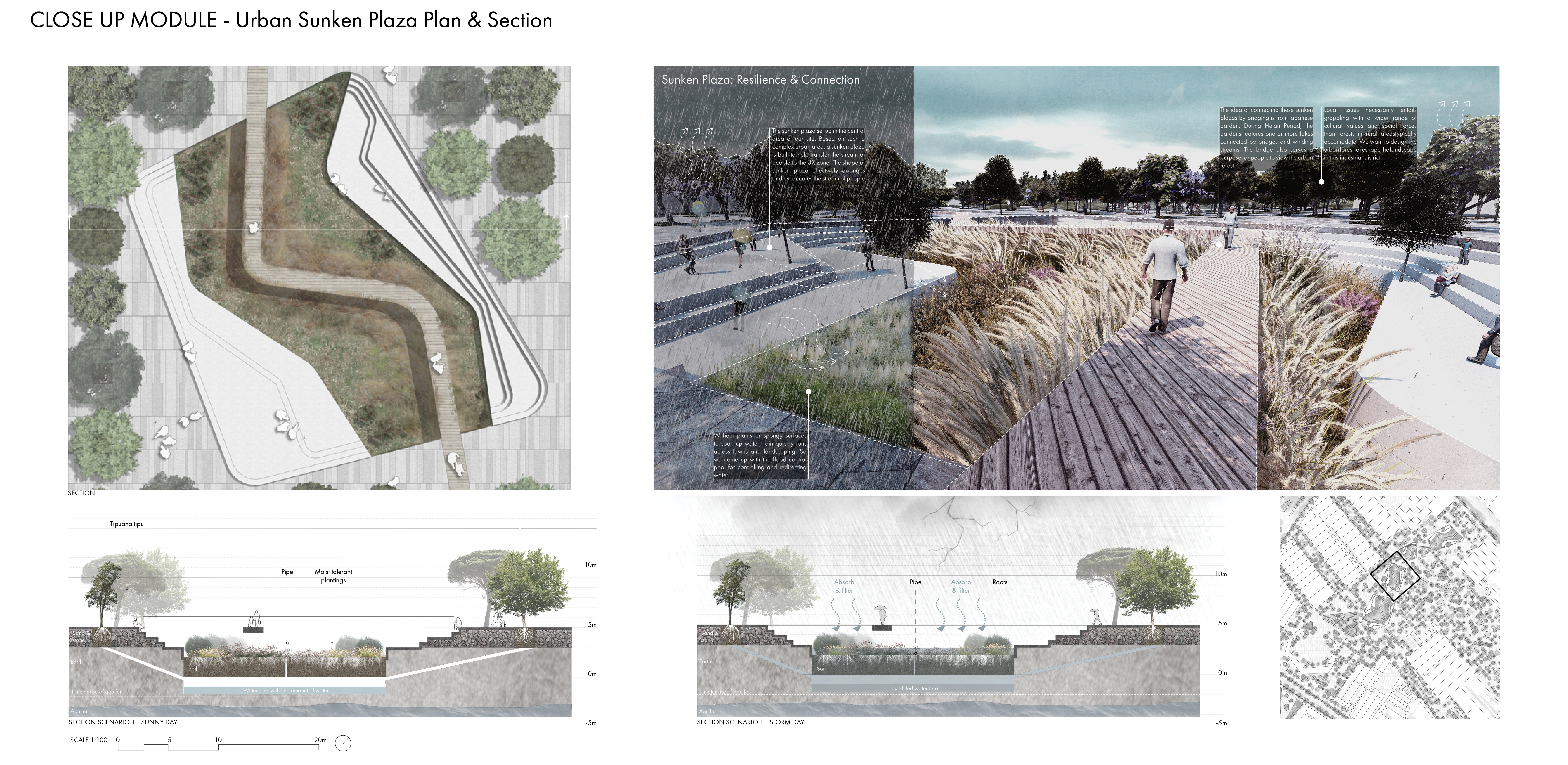
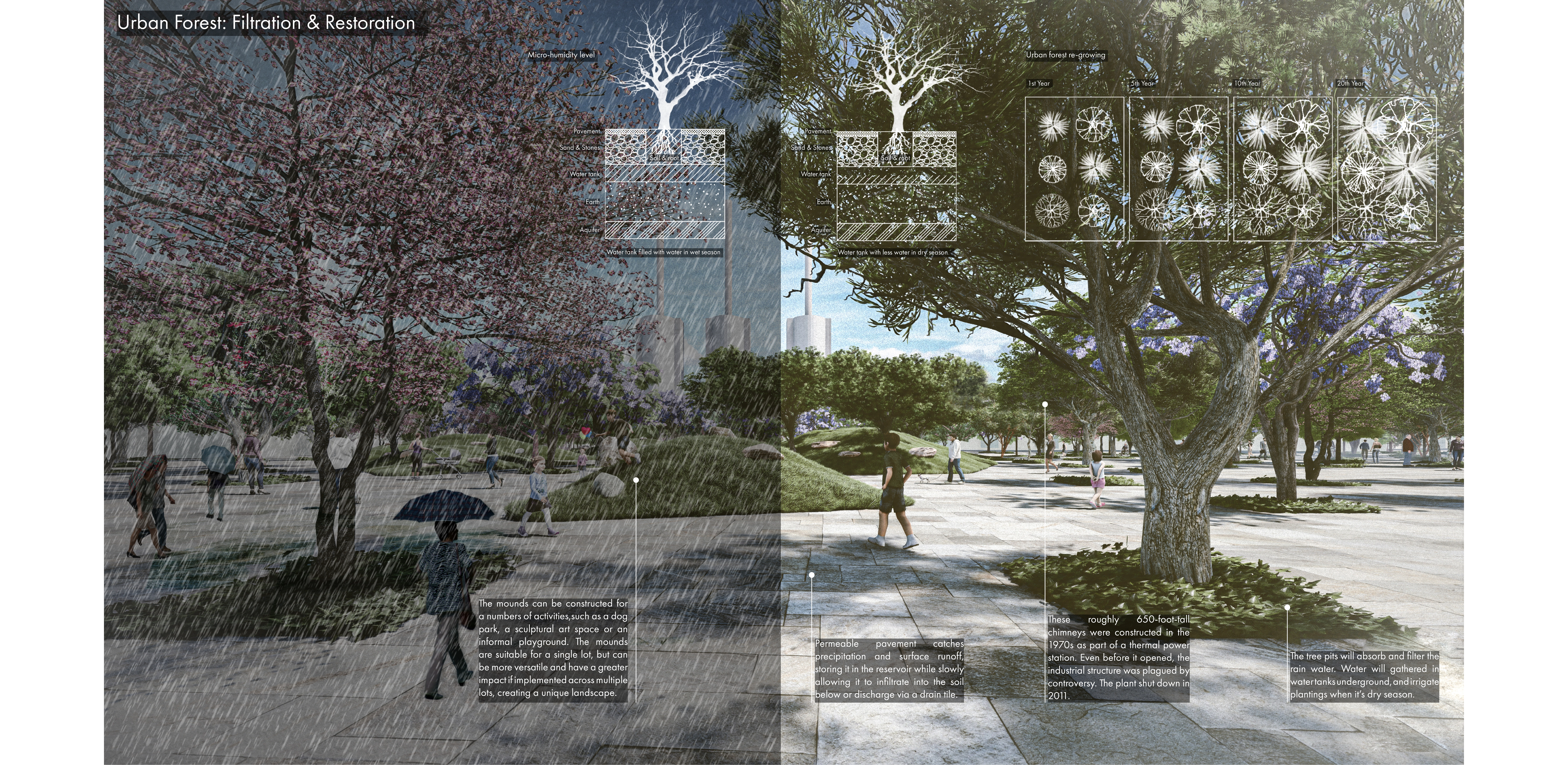
The urban zone with sunken plazas and urban forestry at its center tries to create this micro-climate with moisture and canopy spread for social interactions. And in between these zones this sense of ecotone such as the land bridge would be something as a way forward to really look at the transitions between zones through this journey.
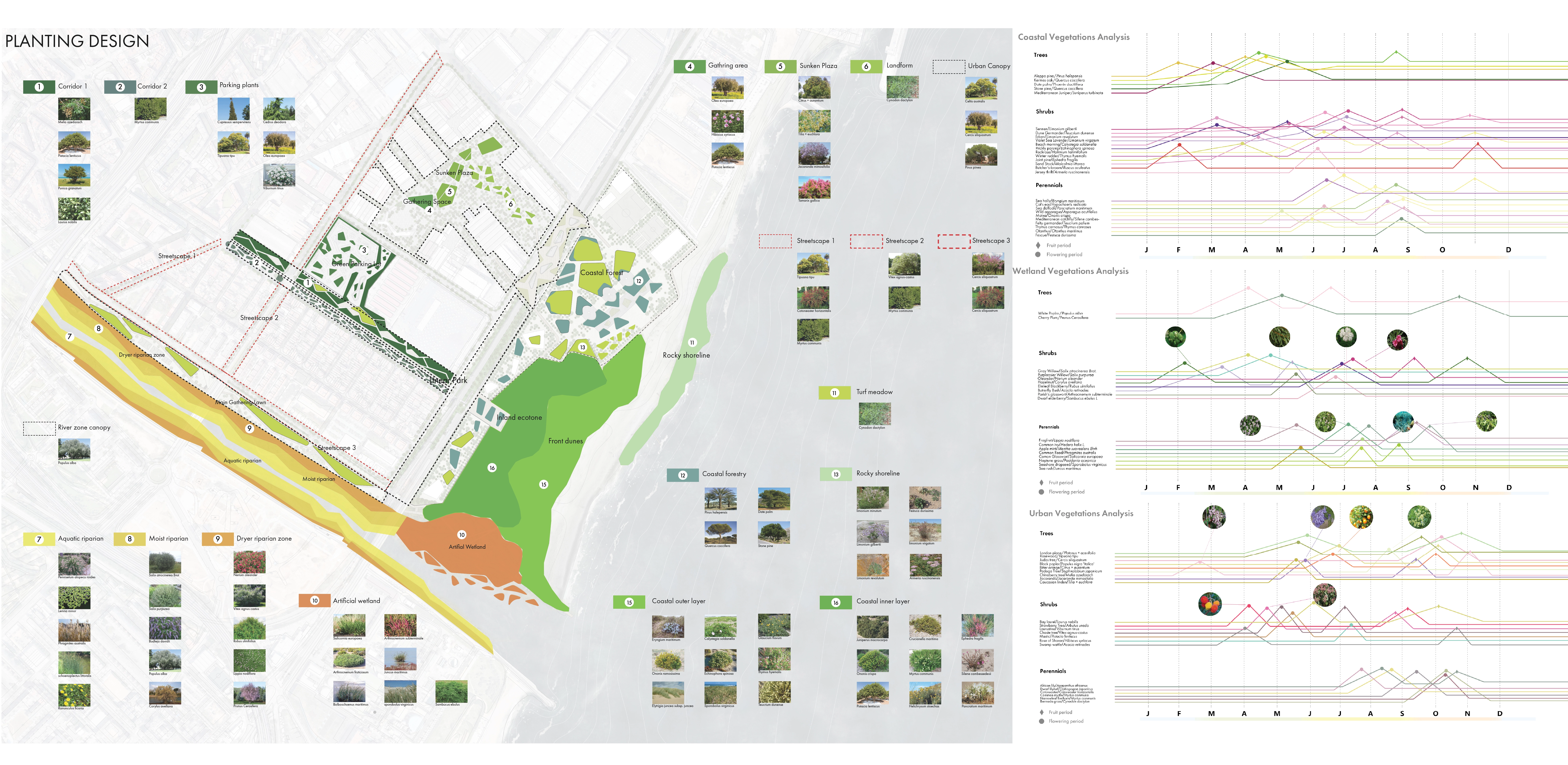
By providing a rich planting palette that relates deeply to the desirable micro-ecosystems of the coast, the river and urban landscapes, “wetness” through diversification of vegetation not only enhances local biodiversity but through the ecological services by which the abundance of native plant communities promote sustainability, they provide a much more dynamic experience that different users can encounter. This is further integrated with programs that allow high level of spatial and social interactions in order to revitalize the regional neighborhoods.
The transitions between zones are also well articulated and meticulously designed through planting overlaps which begins to blur their boundaries allowing fluid change in spatial experiences as you go from one place to another.
Through rich diagrammatic perspectives, the design’s versatile experiential qualities of “wetness” are visualized with a demonstration of the project’s sensitivity to time. Scenario building and projection illustrates the adaptability and resiliency of the design from floods, extreme weather to sea level rise and how strategies respond to changes as well as the opportunities for diversity and inclusion. They reflect the design’s performative, functional and experiential qualities that are flexible and constantly negotiating with the systems at play.
Bringing “Wetness” Back into the City is a project that is dynamic and ambitious in addressing wicked problems through rigorous site analysis and robust design investigations, explorations and projections.
-
- Jersey thrift
- Dwarf Statice
- Beach morning
- Rockrose
- Mediterranean Juniper
- Stone pine
- Mediterranean hackberry
- Black poplar
- Common myrtle
- Gray Willow
- Round-headded Clubrush
- Sea rush
- Fig Buttercup
- Lilac Chastetree
Advertisement
Related Awards
Award of Excellence, General Design
A Floating Forest: Fish Tail Park in Nanchang City
In Nanchang, within the Yangtze River floodplain, we revitalized a heavily degraded 126-acre landscape into a floating forest that manages stormwater, restores habitats, and provides diverse recreational spaces—all within a limited budget and a short timeline. This innovative urban nature model strengthens the district’s identity and spurs surrounding development. Fish Tail Park offers a scalable solution for flood-prone regions, seamlessly integrating flood resilience, ecological restoration