Landscapes of Inclusion and Connections for Self-Constructed Settlements in Quito, Ecuador
Honor Award
Urban Design
Quito, Ecuador
Mingyang Sun, Student ASLA; Siying Xu, Student ASLA; Shiqi Ming
Faculty Advisors: David Gouverneur
University of Pennsylvania


This team connects Quito, Ecuador’s urban environment with nearby creek systems at multiple scales, from district maps to infrastructure, buildings, and landscape. These differing perspectives integrate well, and speak to the city’s place and culture. This comprehensive look makes it easy to dive deep into the region, and you really understand and appreciate the challenge of navigating steep topographies and extreme elevation differences. The attention to that topography and terracing is excellent.
- 2021 Awards Jury
Project Statement
Over a billion people around the globe live in unplanned of self-constructed settlements frequently at peri-urban locations, excluded from the benefits of city life, and occupying high-risk sites. Latin America is still considered the continent with the highest social inequalities, manifested in the disconnection between the formal and the informal areas. These areas are characterized by environmental/health problems, the lack of communal services, infrastructure and public spaces, poor accessibility, stigmatized by the formal city, and presenting low income and high levels of violence.
This project posits that landscape-driven approaches are powerful tools to address the aforementioned concerns, fostering social inclusion, and breaking down physical and cultural barriers, connecting the settlements to their natural systems, linking formal areas to the informal ones, improving physical and performative relations among the informal settlements, and establishing productive local, urban, and metropolitan networks. Supported by Quito municipality, a composite of informal enclaves, including Comité del Pueblo, La Bota, and Puertas del Sol, located on rather flat land in the north-east of Quito, Ecuador was selected as the site.
Project Narrative
Overview
Over a billion people around the globe live in unplanned of self-constructed settlements frequently at peri-urban locations, excluded from the benefits of city life, and occupying high-risk sites. Latin America is still considered the continent with the highest social inequalities, manifested in the disconnection between the formal and the informal areas. These areas are characterized by environmental and health problems, the lack of communal services, infrastructure and public spaces, poor accessibility, stigmatized by the formal city, and presenting low income and high levels of violence.
This project posits that landscape-driven approaches are powerful tools to address the aforementioned concerns, fostering social inclusion, and breaking down physical and cultural barriers, connecting the settlements to their natural systems, linking formal areas to the informal ones, improving physical and performative relations among the informal settlements, and establishing productive local, urban, and metropolitan networks.
The Site
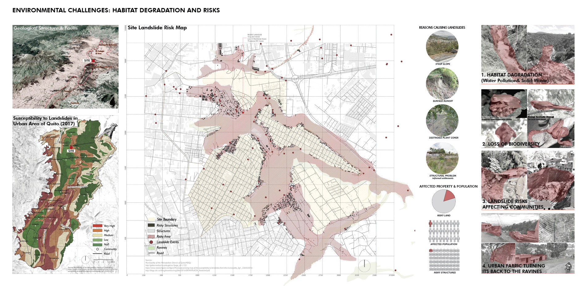
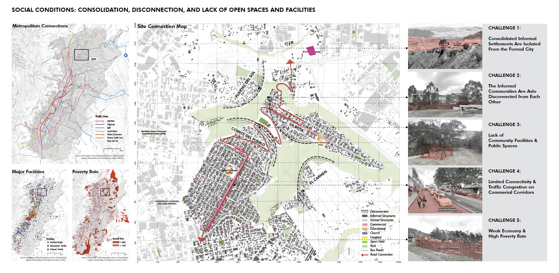
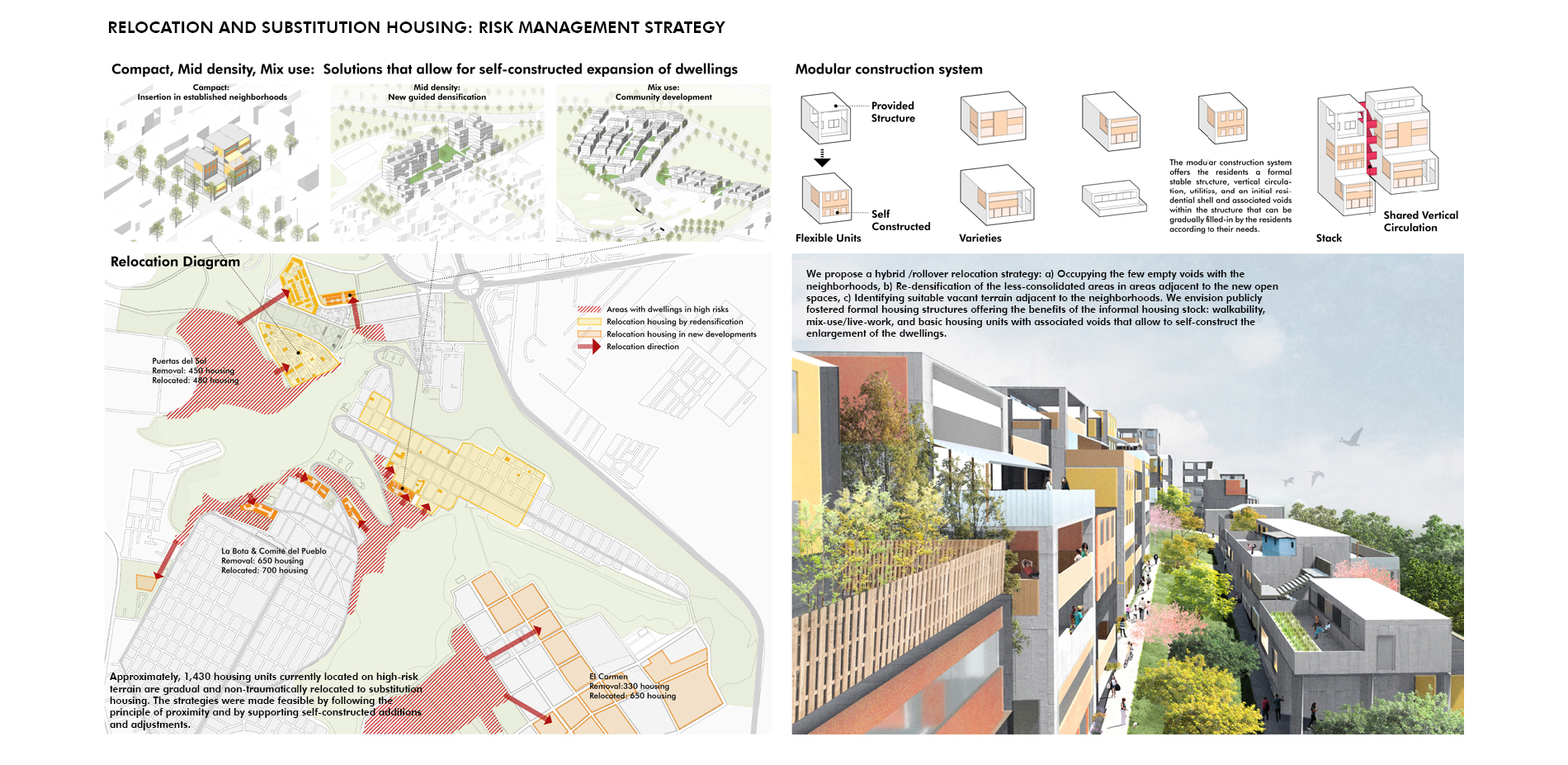
The site selected for this project is a composite of informal enclaves in Comité del Pueblo, La Bota, and Puertas del Sol, located on rather flat land in the north-east of Quito, Ecuador. The neighborhoods are separated from each other and from the formal city by deep ravines, and drastic topographic changes. The gorges contain rich habitats, but they are environmentally degraded, also suffering the biodiversity loss. The neighborhoods turn their back to the gorges, making them out of site and inaccessible. The settlements are highly consolidated, and their housing stock is of relatively good quality. The streets that link the different areas have become active and congested commercial corridors. There are very few open spaces and community services. Structures located at the between the settlements and the gorges occupy unstable high-risk terrain. It is important to note that residents of these neighborhoods would like the improvement of urban conditions, but their social ties and their homes as their most precious assets make it hard for them to move.
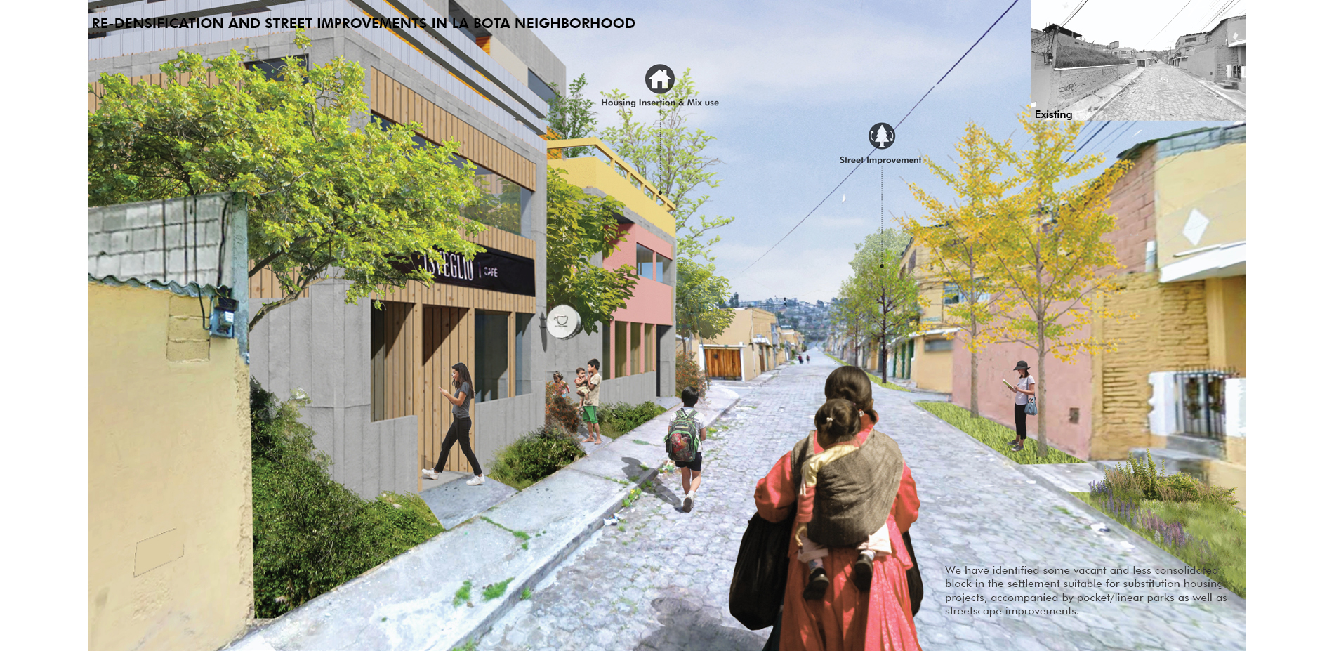
Consequently, the relocation of dwellings from high-risk sites in substitution housing should meet the following conditions: a) provide homes of better quality in proximate sites, b) a gradual relocation process, c) eliminate potential reoccupation of the freed areas by adding beloved public programs with community stewards to ensure activities and provide caring eyes.
The sites were selected by the local government, representing one of the most complex but typical condition of the city. The local government was also supporting the team with valuable GIS mapping, insights, feedback, and encouragement. In March 2021, while this project was being developed, homes located at this fringe condition in Puertas del Sol collapsed with loss of lives, due to landslides and lack of foundations, and the weaking of the terrain by wastewaters. This unfortunate event pointed out the urgent and intertwining issues of risk, governmental neglect, poverty, and lack of technical studies that are common to settlements not only in Quito, but to many other developing cities around the globe.
Strategies
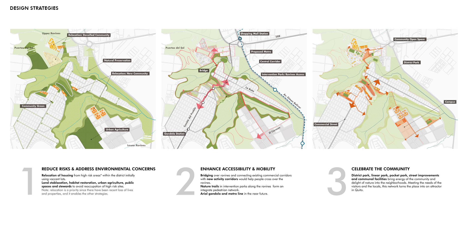
To tackle these interrelated issues, our design team broke down the tasks into three categories: to reduce risks and address environmental concerns, to enhance accessibility/mobility, and to celebrate the community.
1) Reduce Risks and Address Environmental Concerns
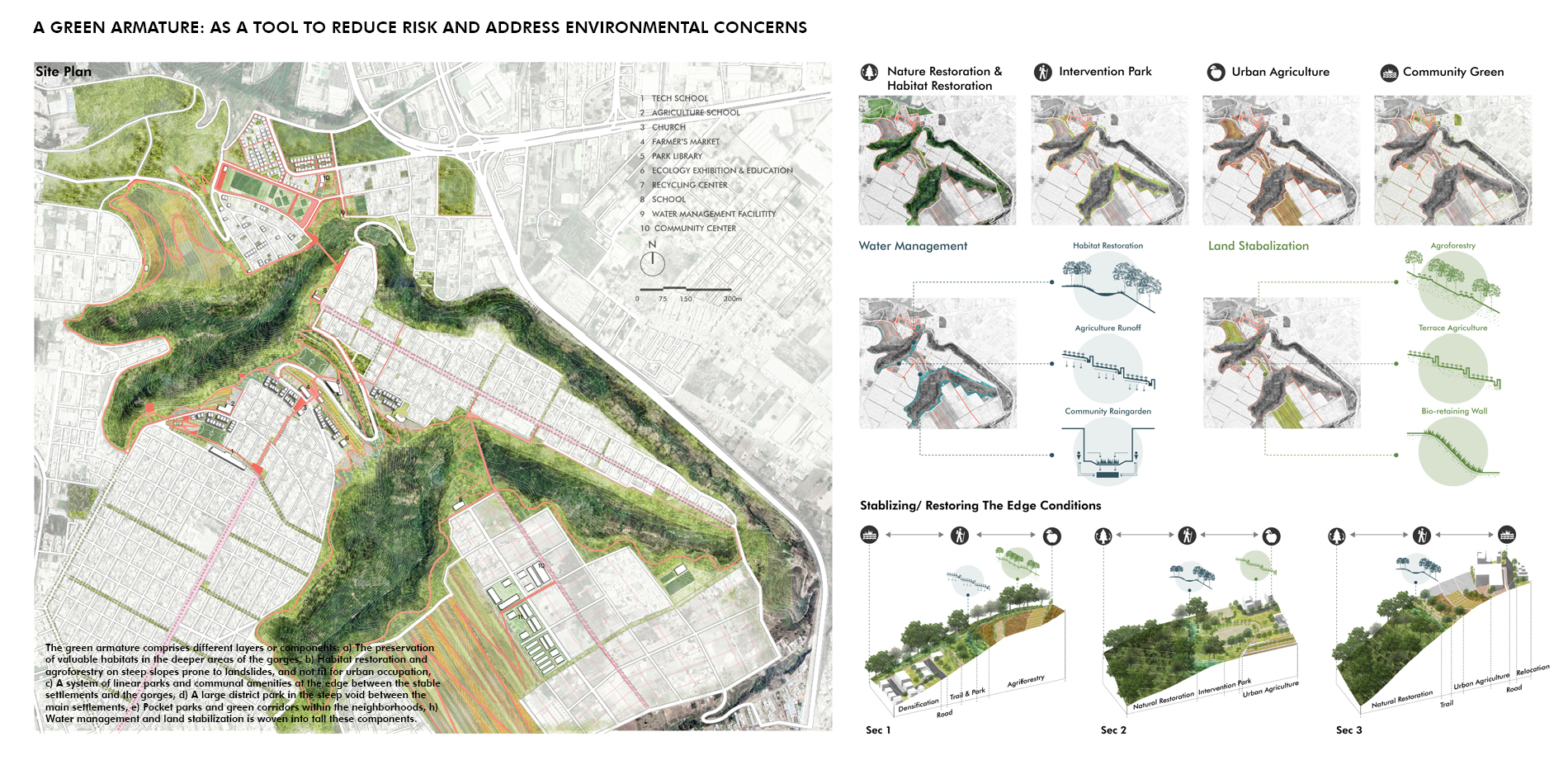
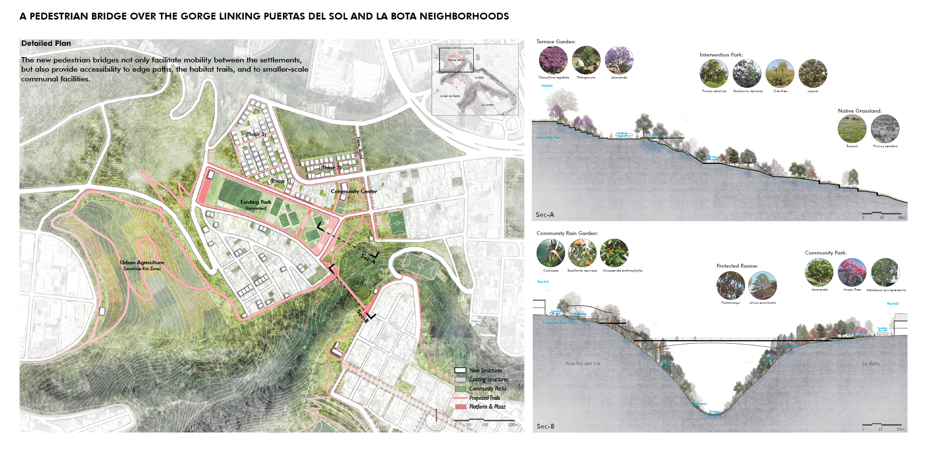
The project employed both landscape and housing relocation strategies. The landscape strategies consist of different interrelated approaches: a) The protection and enhancement of the best-preserved natural habitats, b) Afforestation and agroforestry programs in areas of steep slopes and difficult accessibility, c) A system of linear parks at the edge of the gorges as a buffer or transition between the urban fabric and the ecological/green systems, d) A large district park with communal facilities in the sloping terrain that disconnects el Comité del Pueblo from la Bota, and e) Pocket parks and green corridors within the urban fabric connected to the larger edge/green armatures. Land stabilization and water management are woven into the aforementioned strategies.
Relocation from high-risk areas is a priority due to potential life-threatening risks, and it enables the aforementioned strategies by freeing spaces. This task is challenging due to the density and consolidation of the neighborhoods, and the difficulty to identify terrain appropriate for the relocations process.
The relocation strategy follows the principle of proximity to make the process gradual, non-traumatic and feasible. Residents should be relocated in the same neighborhood as they did before, by 1) Utilizing the few vacant or underutilized sites within the existing urban fabric, 2) Re-densification of stabilized land and/or construction of solid foundations, and 3) Detecting stable non-urbanized terrain adjacent to the communities.
To embrace the positive qualities of the self-constructed fabric, modular construction system is deploed to offer the scale and character of the informal neighborhoods, pedestrian friendly, walk-up and mix-use/live-work solutions.
2) Enhance Accessibility/Mobility
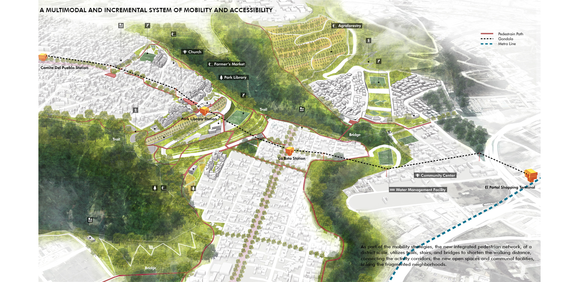
The current accessibility/mobility restrictions and barriers are a result of: a) The drastic topographic conditions, b) Congestion due to through traffic through the only connecting streets and commercial corridors, c) The lack of walkability due to lack and poor quality of the open spaces, d) A large undeveloped steep terrain, and e) The inaccessible habitats of the gorges and ravines.
In response to these issues, at a district scale we propose a pedestrian network including trails, stairs and bridges to shorten the walking distance by almost 75 percent, and to adapt to steep terrain, while connecting the activity corridors, the new open spaces and communal facilities, linking the currently fragmented neighborhoods.
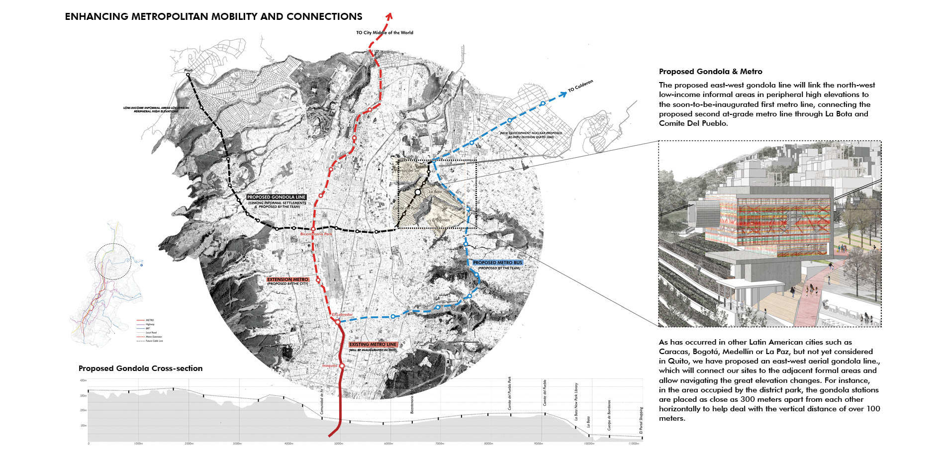
At an urban metropolitan scale, we envision that this pedestrian network can be easily connected to the mass transit system. We have proposed an east-west aerial gondola line, generating link among the north-west low-income informal areas in peripheral high elevations, the first Metro line, our site, and a second at grade metro line we suggested to connect to the east. The gondola stops in our sites could connect our sites to the adjacent formal areas and help navigate the great elevation changes. This system will also reduce congestion, increase accessibility, foster social inclusion, provide amenities, and enhance economic activities.
3) Celebrate the Community
The project celebrates the community by developing a network of diverse social facilities integrated to the green armatures, public spaces, and mobility/accessibility layers to strengthen communal ties and make the different areas active and safe. Some of the facilities serves at a neighborhood scale, and others may also attract users from more distant locations.
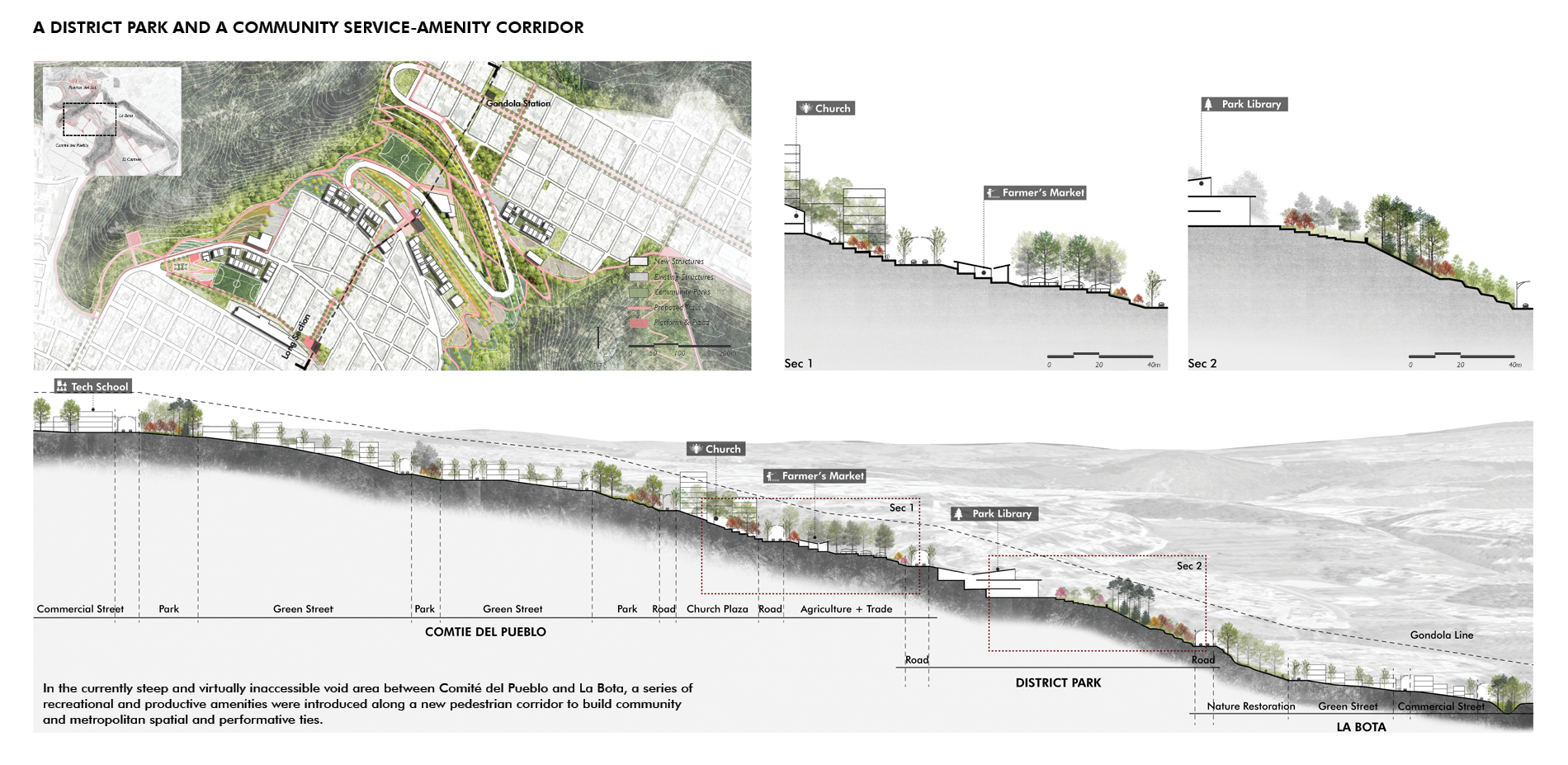
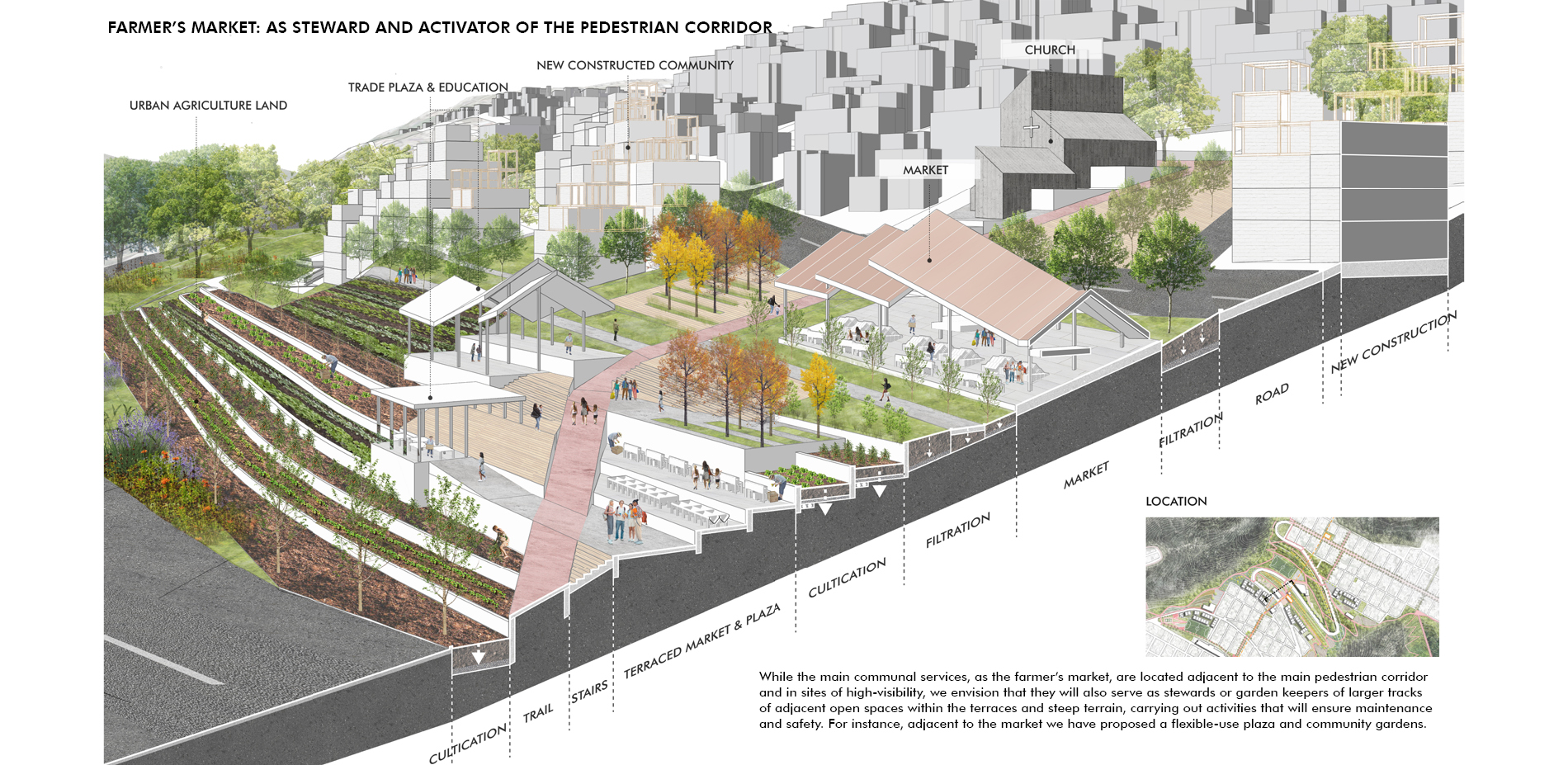
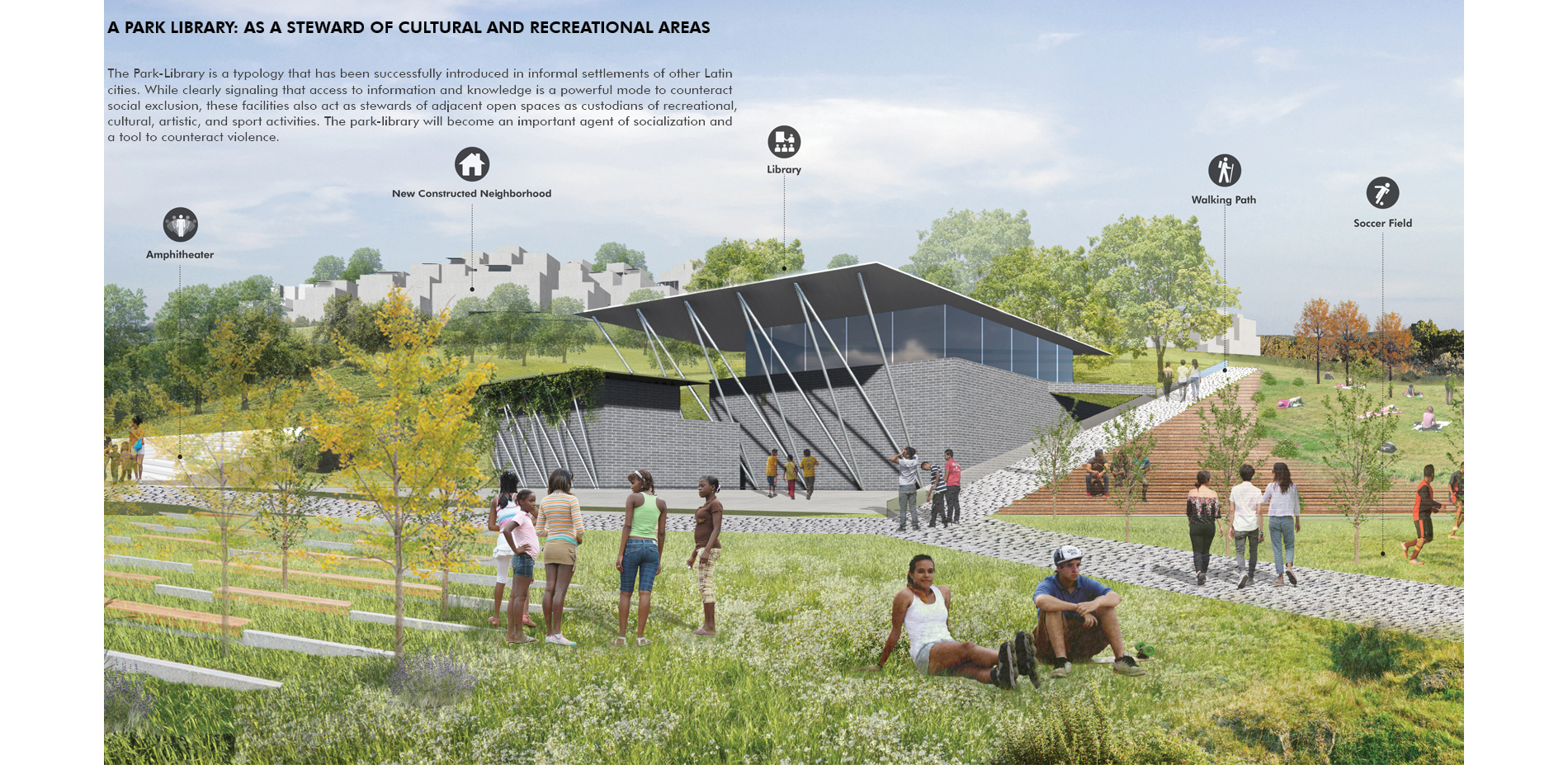
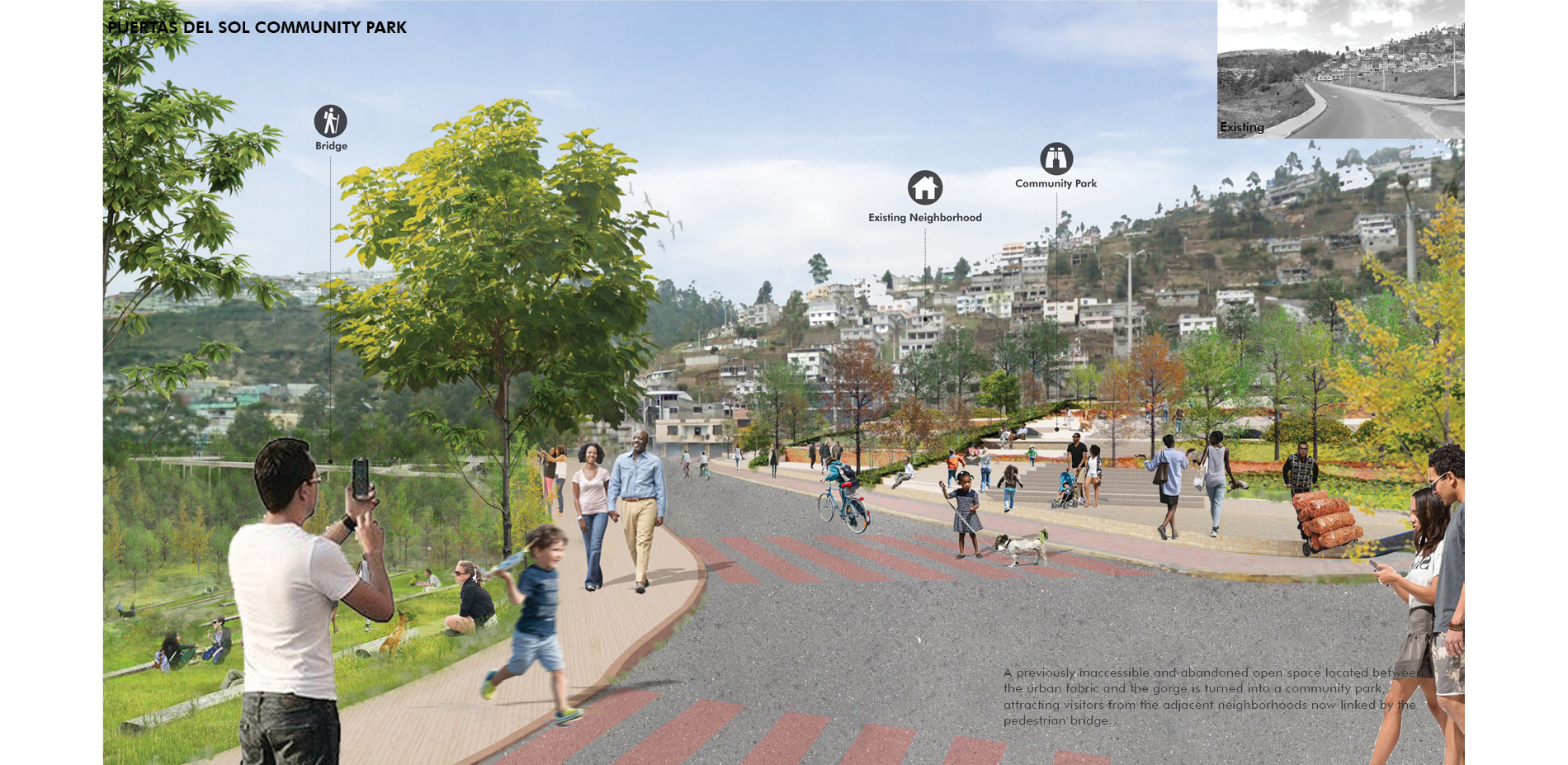
As an example of the last category, our team developed in more detail the district park and service center located between Comité del Pueblo and La Bota, turning the steep and virtually inaccessible void into a diversity of recreational and productive amenities. A sequence of activity nodes/facilities were distributed onto different terraced elevations and linked by a pedestrian corridor to elevate the accessibility and user experience. Some facilities, such as the farmer’s market and the park-library, serve as stewards for the larger adjacent open spaces areas while providing economic benefits or public amenities. The multiuse plaza near the farmer’s market was designed to accommodate a risen gondola station in the near future, which will further enhance the accessibility, the activities, and the visibility of this important area.
The pedestrian bridge between Puertas del Sol and La Bota linking these now detached neighborhoods provides an example of neighborhood-scale communal facility. It connected to the system of edge trails/opens paces, allow engaging with the habitats of the ravines, and generate access to smaller scale communal facilities. The combination of landscape-based moves, accessibility/connectivity proposals, and more architectural/social oriented facilities all aim to encourage social gathering, dignify and celebrate the communities.
Conclusion
Our team and the municipal government see this pilot project as an opportunity not only to address compelling social, urban and environmental challenges of the site, but also to formulate criteria, course and actions and prototypical design solutions that can be adapted to address self-constructed neighborhoods with similar conditions around the world.
Plant List:
- Cholan
- Carob
- Magnolia
- Pumamaqui
- Alnus acuminata
- Arupo Tree
- Tibouchina lepidota
- Pittosporum
- Jacaranda
- Prunus serotina
- Escallonia resinosa
- Grevillea
- Colocasia
- Mussaenda erythrophylla
- Tussock