
.webp?language=en-US)


Parsons Island Conservation and Regeneration Plan
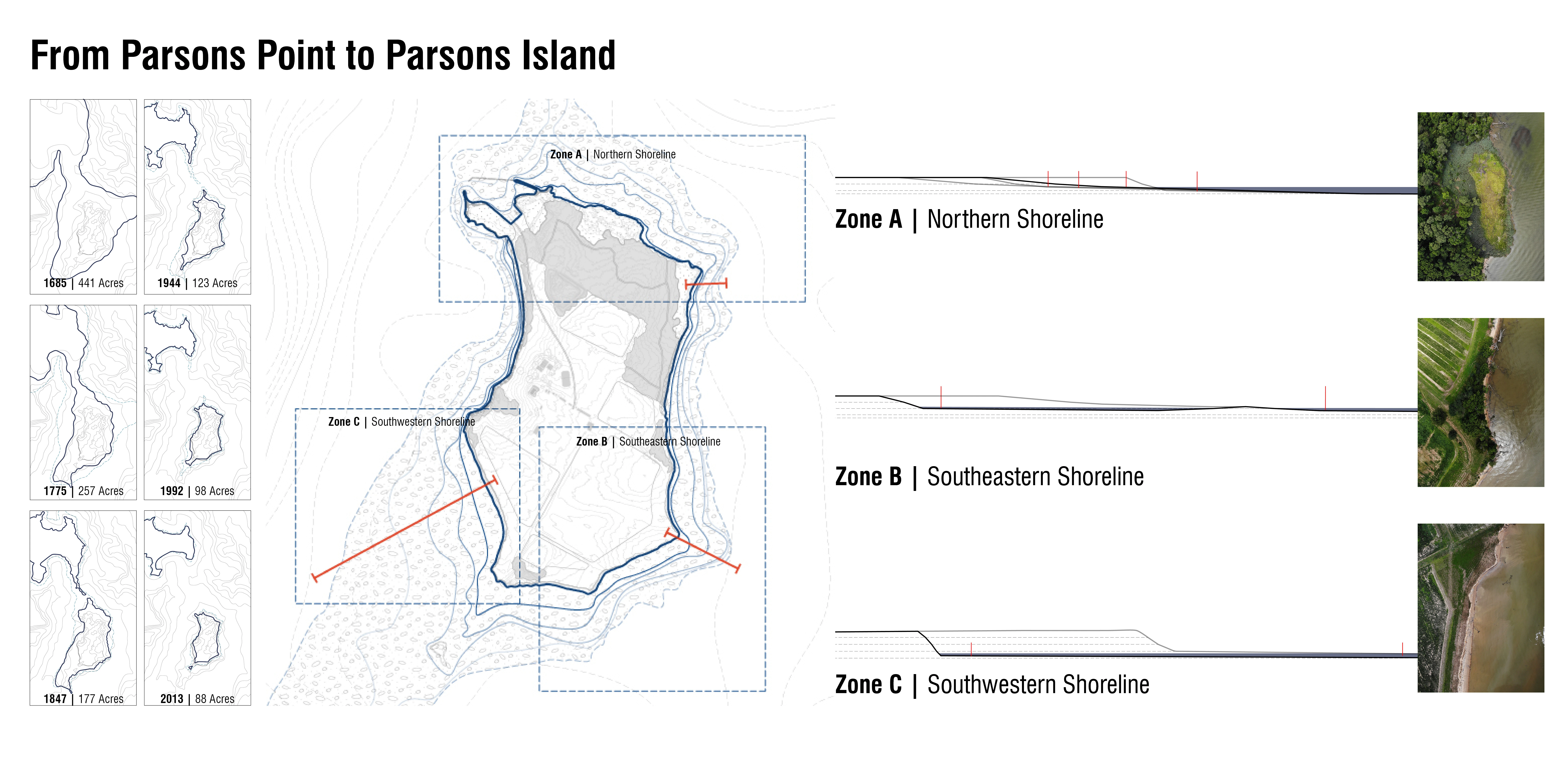
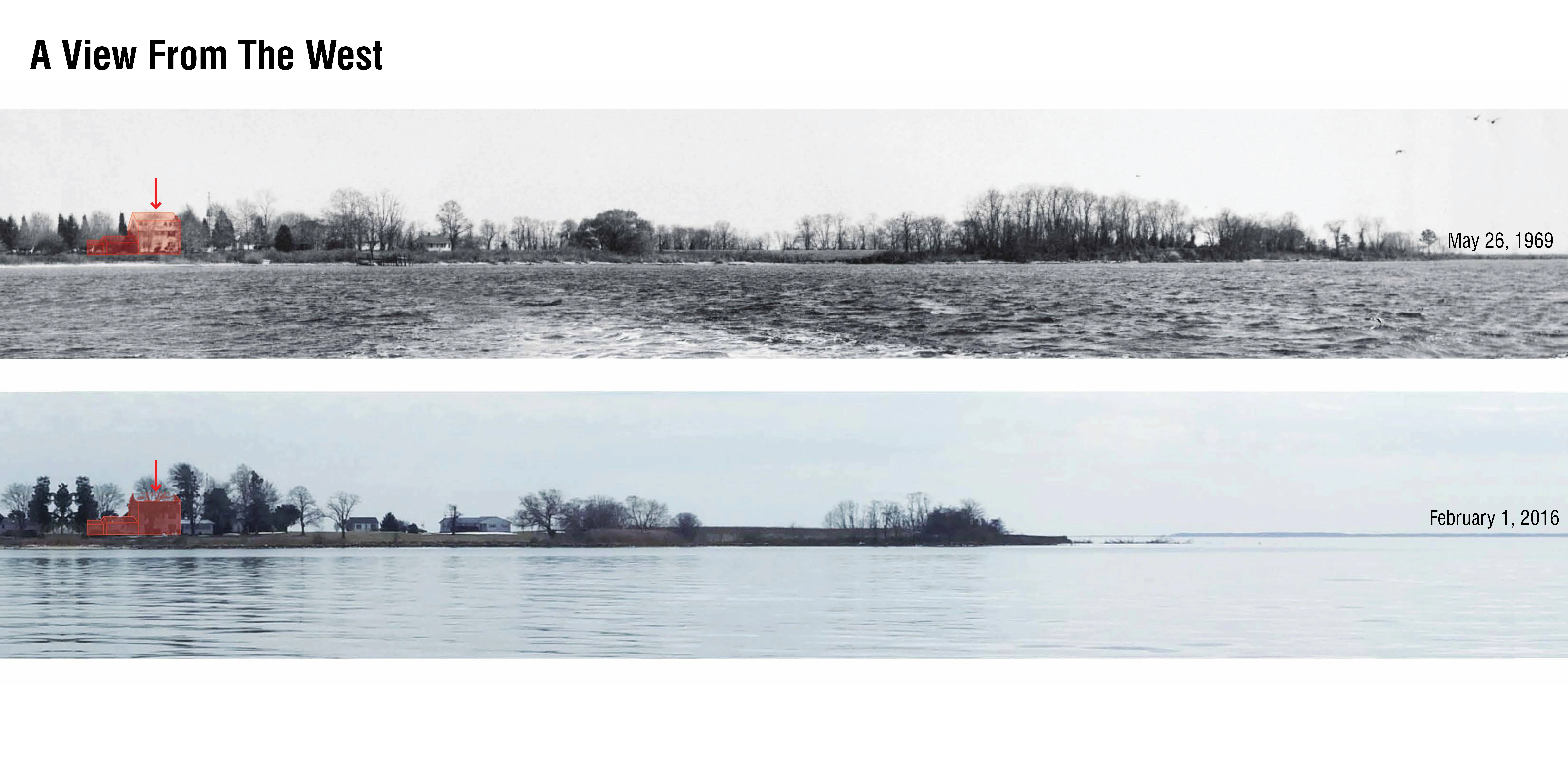
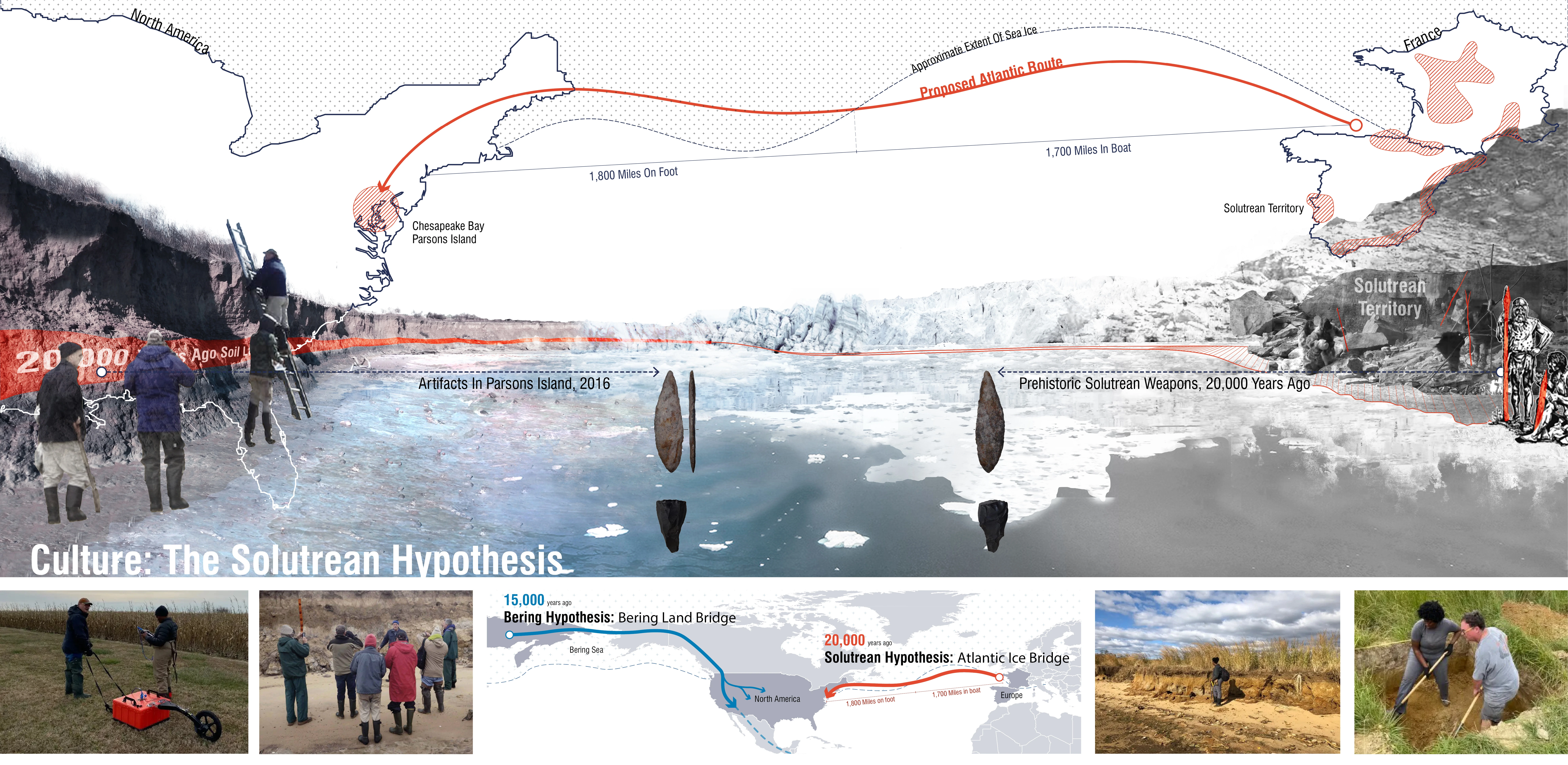
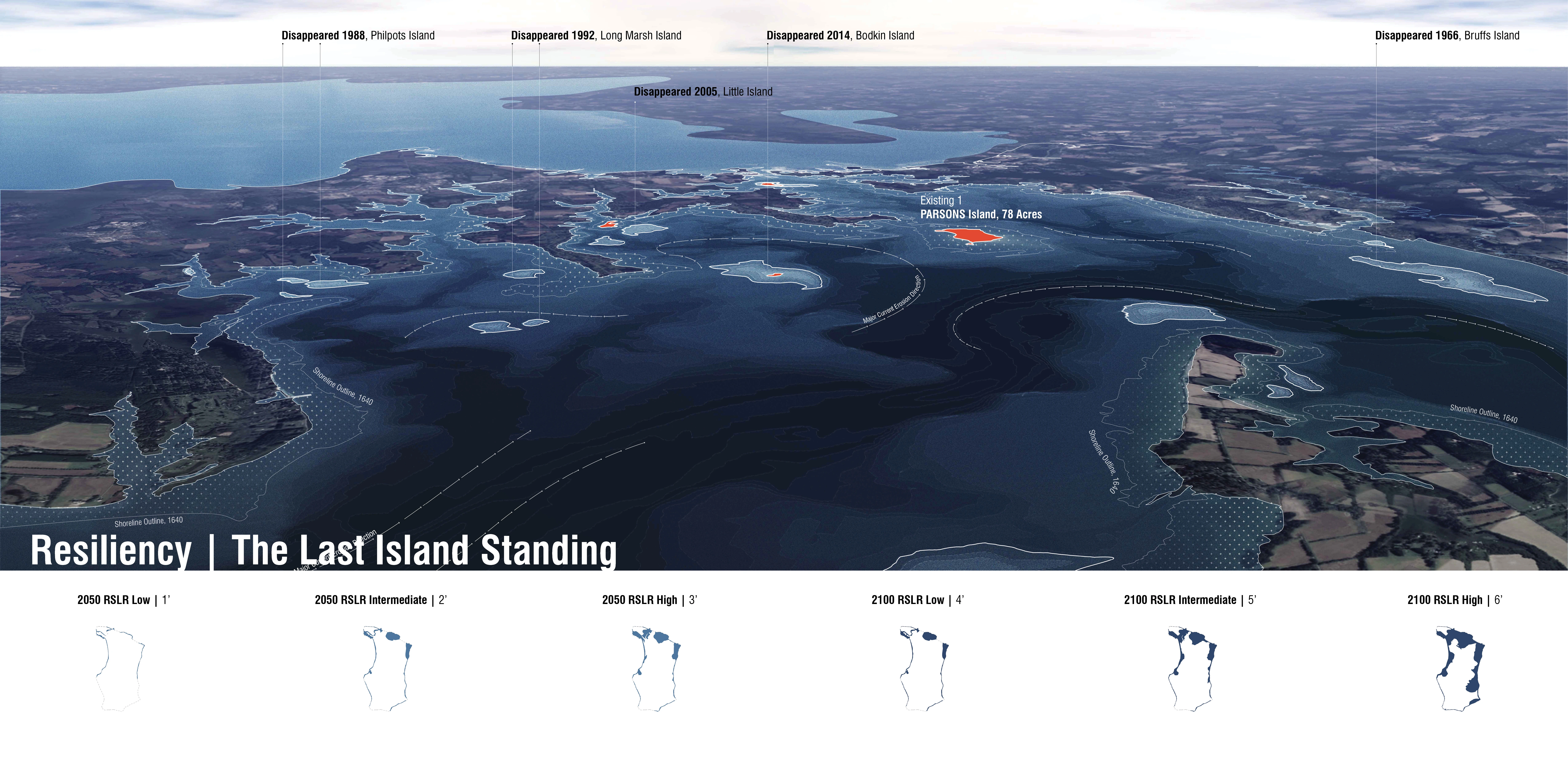
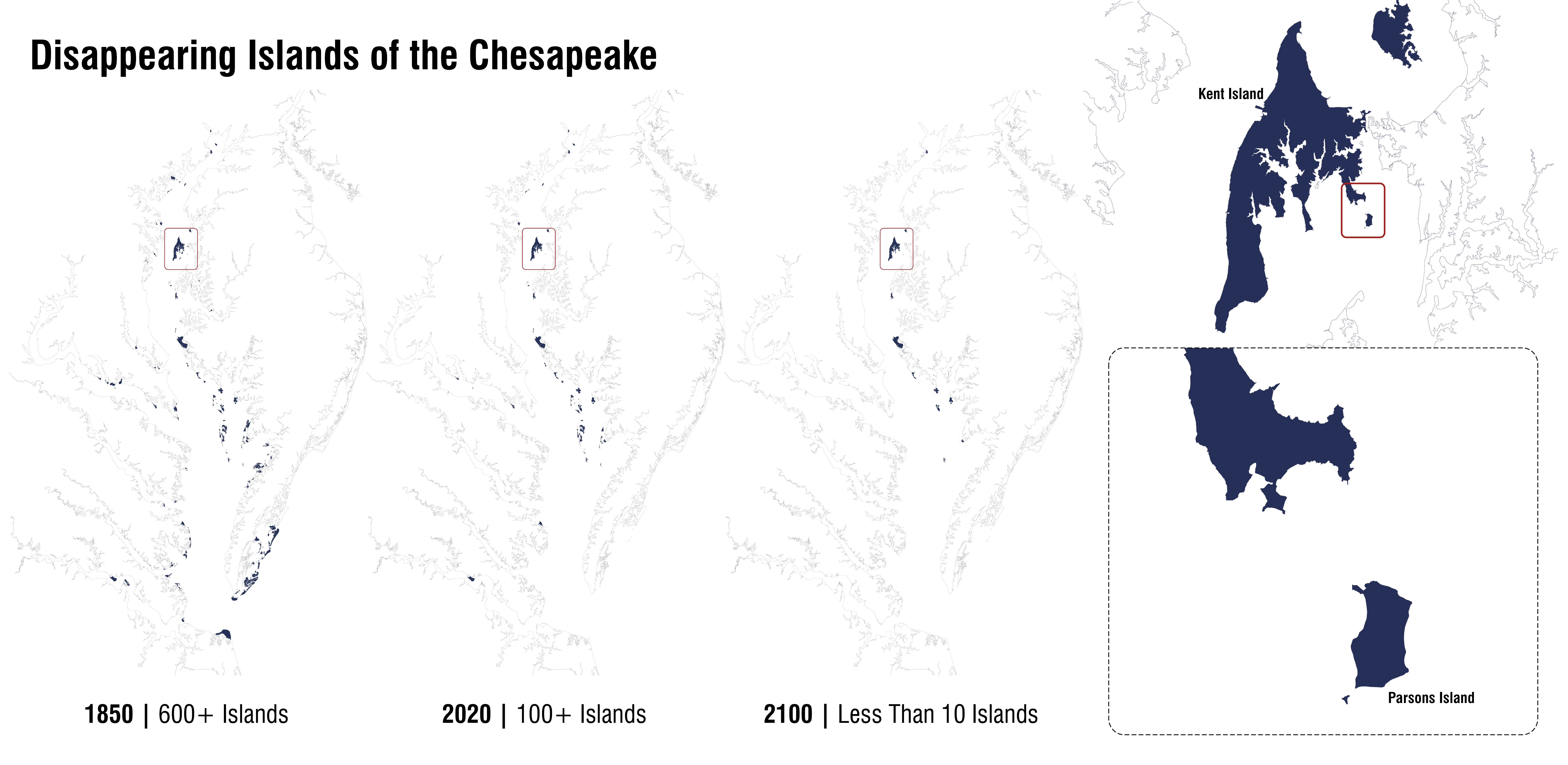
Rising waters and sinking land are the story of Parsons Island in the mid-Atlantic Chesapeake Bay: mapped in 1685 as a 447-acre island, it is today a mere 77 acres, with relative annual sea-level rise of approximately 5 mm combining with natural and recreational waves to further subsume the island. Yet recently unearthed artifacts on the island suggest inhabitation more than 20,000 years ago, suggesting the need for urgent preventative measures to mitigate the island’s subsidence and restore its habitats. Reliance on measures that can be done individually or in small groups—as well as opportunistic reallocation of dredged sediment—will enable the Parsons Island Conservation and Regeneration Plan’s success through collective stewardship of an important aquatic asset.
Awards Jury
-
Hundreds of islands have vanished beneath the waters of the Chesapeake Bay. Since 1850, this includes approximately 10,500 acres of island habitat as well as an unknown number of invaluable cultural and archaeological artifacts, some dating back 20,000 years. Land subsidence, rising sea level, and wave-induced erosion, both natural and anthropogenic all contribute to and compound this ongoing and accelerating landscape saga. The Parsons Island Conservation and Regeneration Plan proposes to collocate opportunities for cultural resource conservation, habitat regeneration, and resiliency enhancements on this unique Chesapeake Bay island as both a means and method to catalyze collective action and stimulate impactful stewardship. Considered within the context of large-scale, federally funded island restoration projects in the Chesapeake Bay, this cooperative and adaptive undertaking represents a new approach in addressing the loss of valuable islands in the nation’s largest estuary.
-
CONTEXT
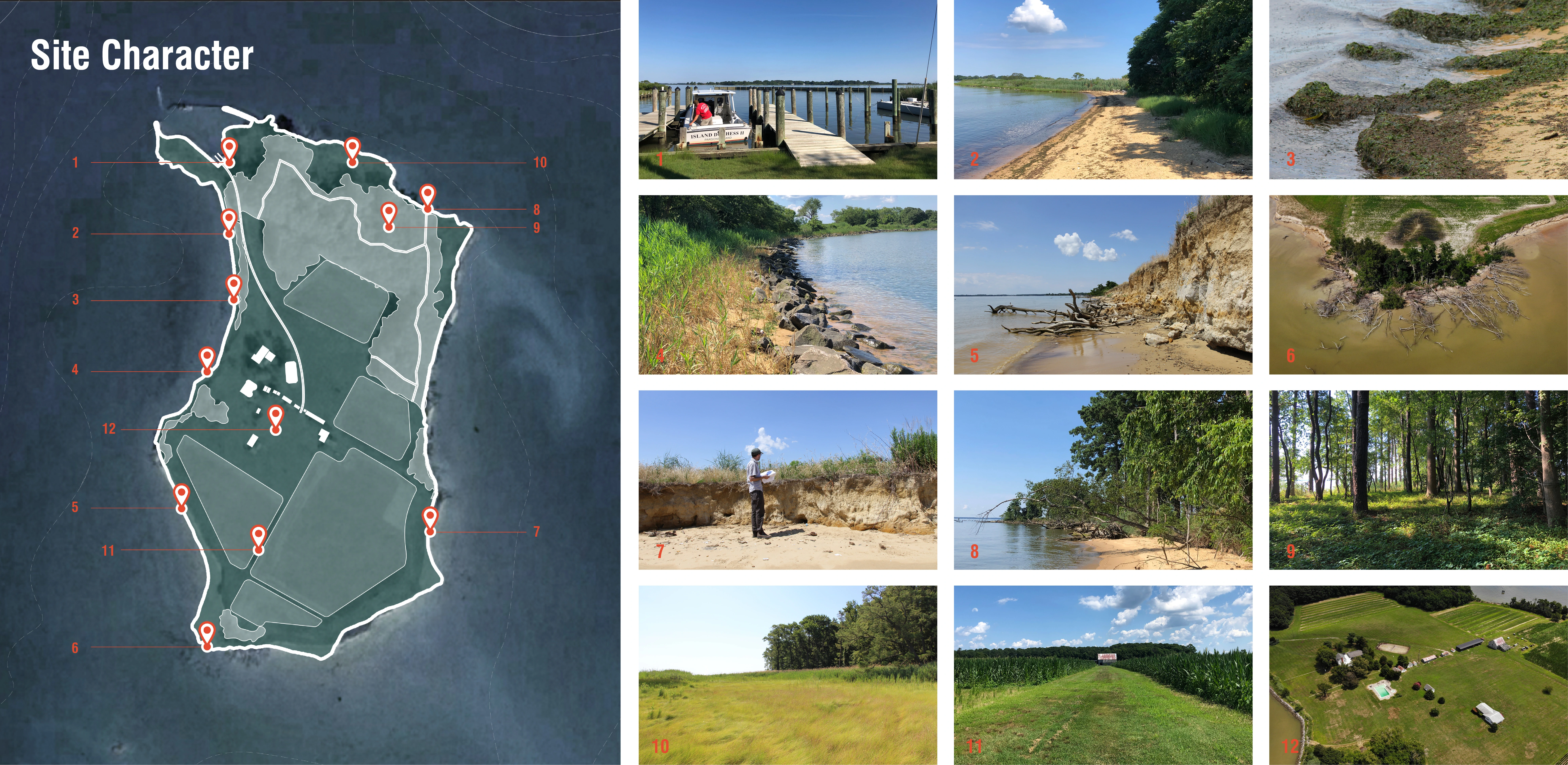
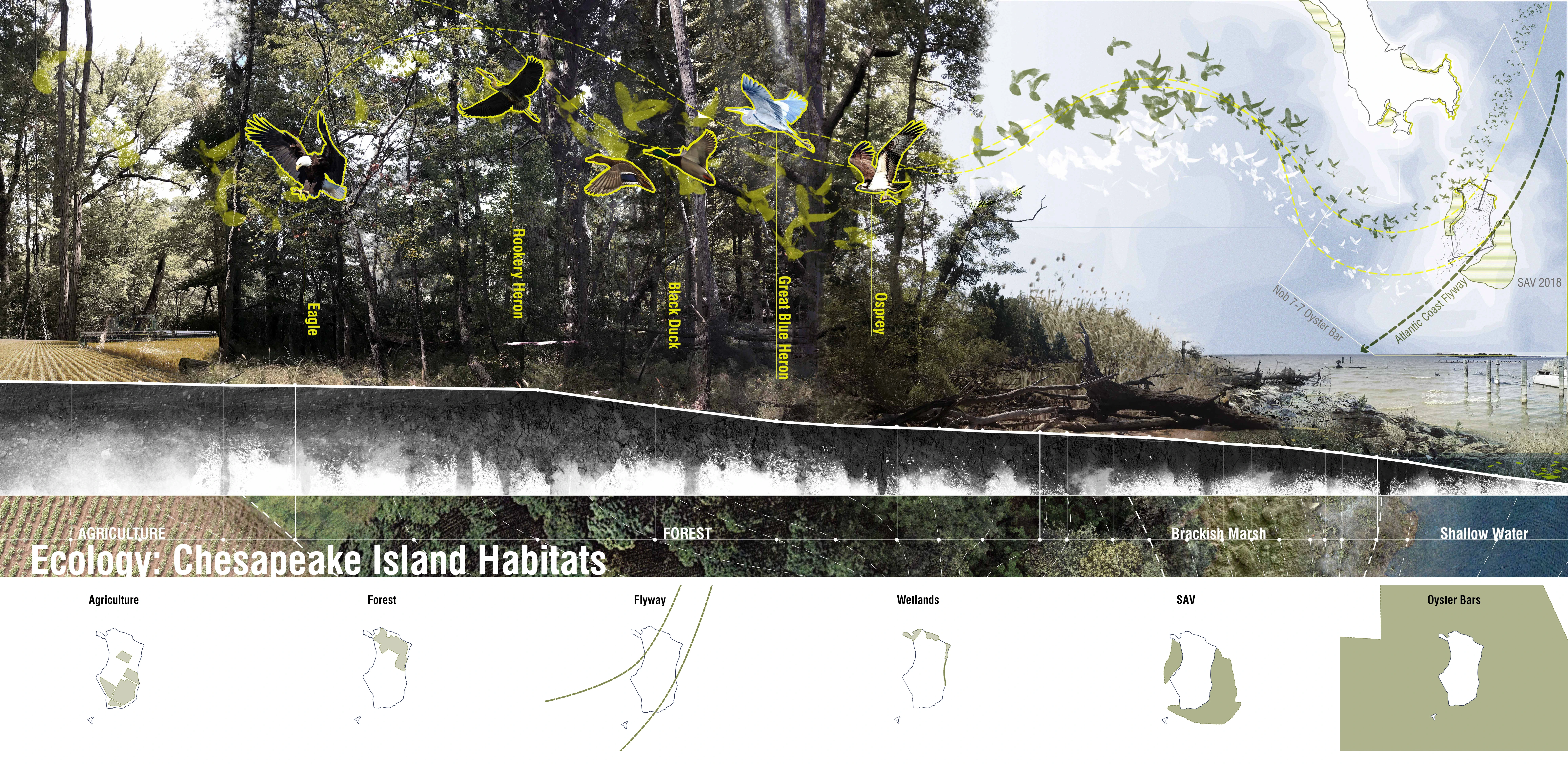
Parsons Island, located in Queen Anne’s County, Maryland is 3.5 nautical miles south of Kent Narrows and 8.5 miles southeast of the Chesapeake Bay Bridge. The Island’s 78 extant acres of forests, fields, marshes, open water, and a homestead are what remains of a 441-acre peninsula of Kent Island mapped by European settlers in 1685 and first described as Parsons Island in 1847 at 177 acres. However, this Enlightenment-Era European history does not suffice in understanding the island’s true value. Artifacts discovered by a Smithsonian affiliated archaeologist along the Island’s eroding southwestern shoreline indicate that Parsons’ original inhabitants were pre-native people whose origins span the Atlantic Ocean to the Solutré territory of east-central France some 20,000 years ago – suggesting a new timeline and arrival route for human settlement on the North American continent. The island’s rich past and unique cultural resources are mirrored by its vibrant and textured ecological present and includes rare Chesapeake Island forest habitat designated as a targeted ecological area by the Maryland Department of Natural Resources. The island also includes tidal wetlands, mudflats, oyster bars, submerged aquatic vegetation (SAV) beds, and farm fields that serve as critical habitat for resident and migratory birds, mammals, reptiles, amphibians, fish, arthropods, and mollusks. Like its cultural resources, however, Parsons ecological assets are at risk due to its continued erosion. Yet despite its diminished size and threatened cultural and ecological resources, as one of the only islands remaining in Eastern Bay, Parsons’ presence and persistence continues to provide an essential infrastructural service as a resiliency buffer against wind-induced waves and climate generated storm events in the basin.
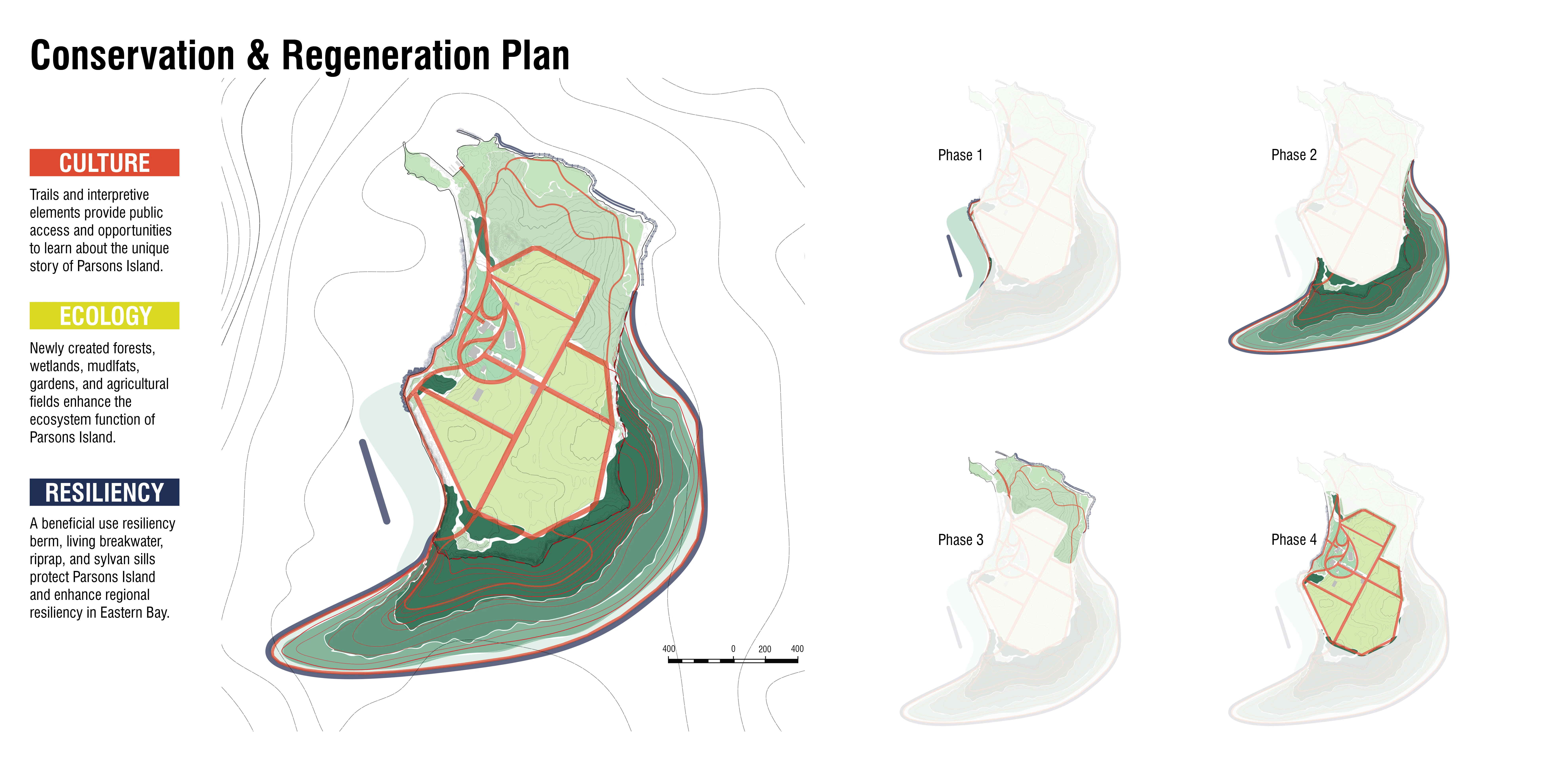
To ensure that Parsons Island’s cultural, ecological, and resiliency values not only continue to contribute to life in the Chesapeake, but also benefit the public in perpetuity, the Island’s owners partnered with the Chesapeake Conservancy and a team of landscape architects, engineers, and researchers to develop the Parsons Island Conservation and Regeneration Plan for the property. Both the plan and the planning process were structured to catalyze collective action and stimulate impactful stewardship. Central to this cooperative undertaking is incremental implementation and strategic enhancements to Parsons Island’s existing cultural, ecological, and resiliency assets, as well as the creation of new opportunities for public access, education, and recreation.
COMPOUND CHALLENGES
The challenges facing Parsons Island are considerable and compound, but not unique. In the Chesapeake Bay, rising sea levels and land subsidence indicate a relative sea level rise of between 4.8mm – 6.3mm annually; close to three times the global average of 1.7mm per year. The rising waters and subsidence of land in the Bay, combined with wind and boat-driven waves create a system of forces that have effectively erased hundreds of islands from existence. The dramatic reduction of Parsons from a 447-acre point to a 78-acre island is a sobering story shared by many, now lost, islands within the Bay. Further compounding these environmental challenges are the economic and political forces that align to allocate and appropriate billions of dollars of federal and state funding to mega projects that target island restoration efforts on the magnitude of 1,000+ acres like Hart-Miller Island, Poplar Island, and the Mid-Bay Islands projects, which leaves scant resources for more modest island restoration projects like Parsons. The Parsons Island Conservation and Regeneration Plan responds directly to these compound environmental, economic, and political challenges by collocating opportunities for cultural resources conservation, ecological uplift, and climate adaptation and resiliency.
COLLOCATING OPPORTUNITIES
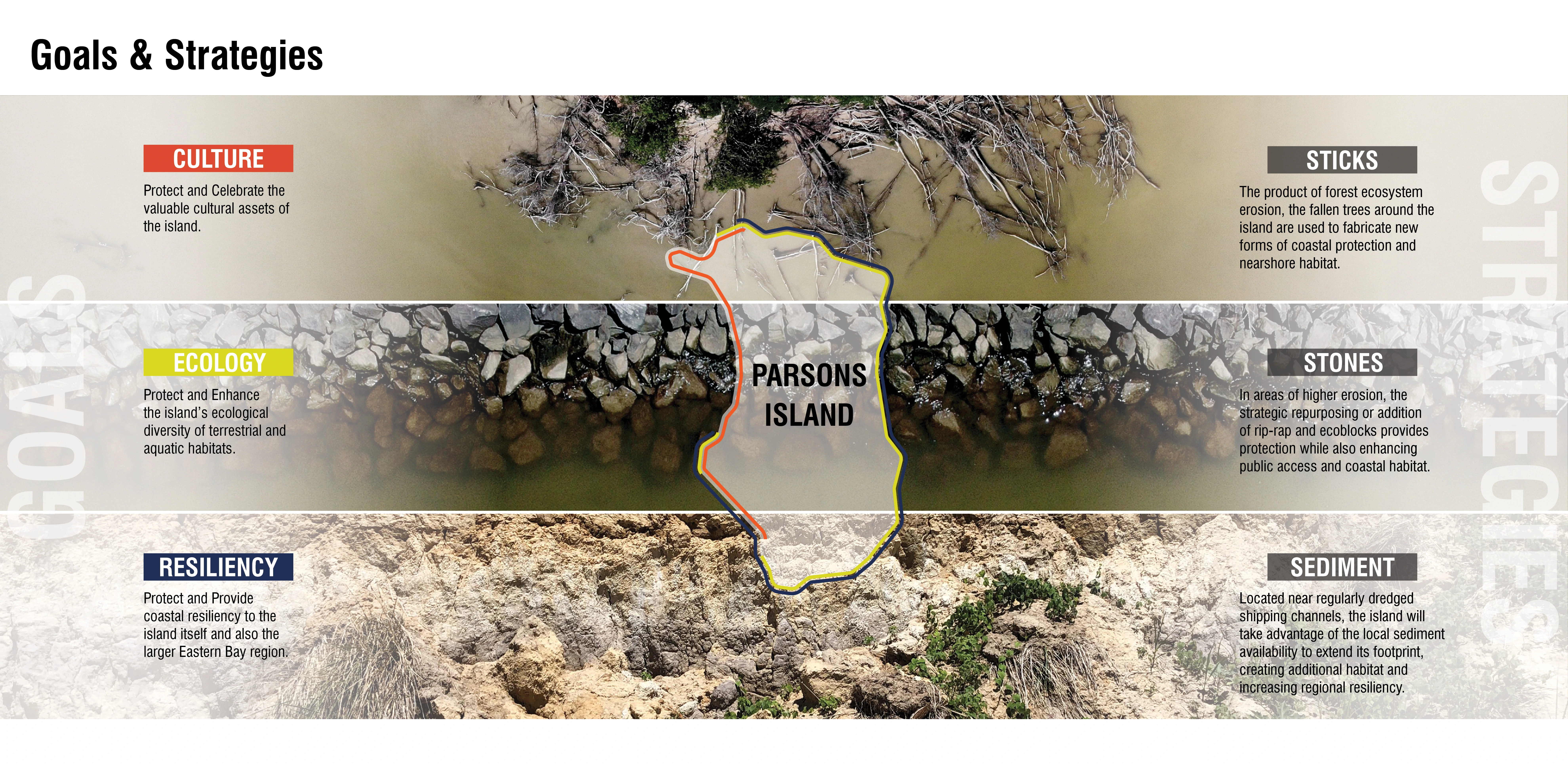
Parsons Island provides a unique opportunity to demonstrate the value of a multi-functional collection of landscape interventions designed to work together to achieve wide ranging public benefits. This strategy of collocating opportunities for enhancements also illuminates and leverages the thickly tethered network of cultural and ecological relationships present within the coastal environments of the Chesapeake – relationships that are invariably influenced by politics and economics. While considered separate subject matters and regulated by a myriad of state and federal agencies, the cultural, ecological and resiliency value of Parsons Island are all linked to one another. These conceptual and physical linkages are the foundation of the Parsons Island Conservation and Regeneration Plan and provide the nexus for development of strategic partnerships, planning frameworks, and site specific design strategies that aim to positively affect all three subjects by positioning each proposed modification within an interconnected system of incremental investments.
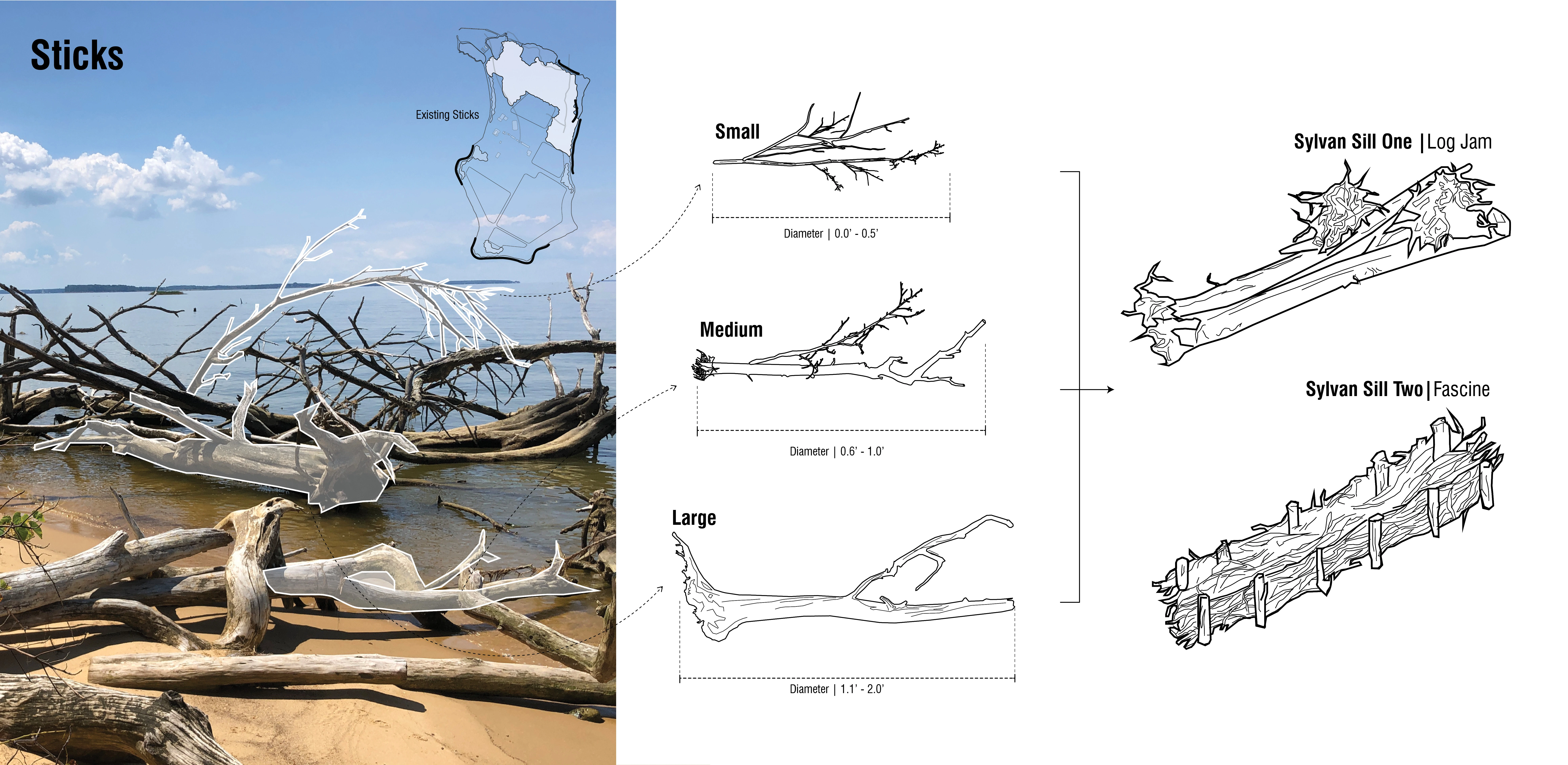
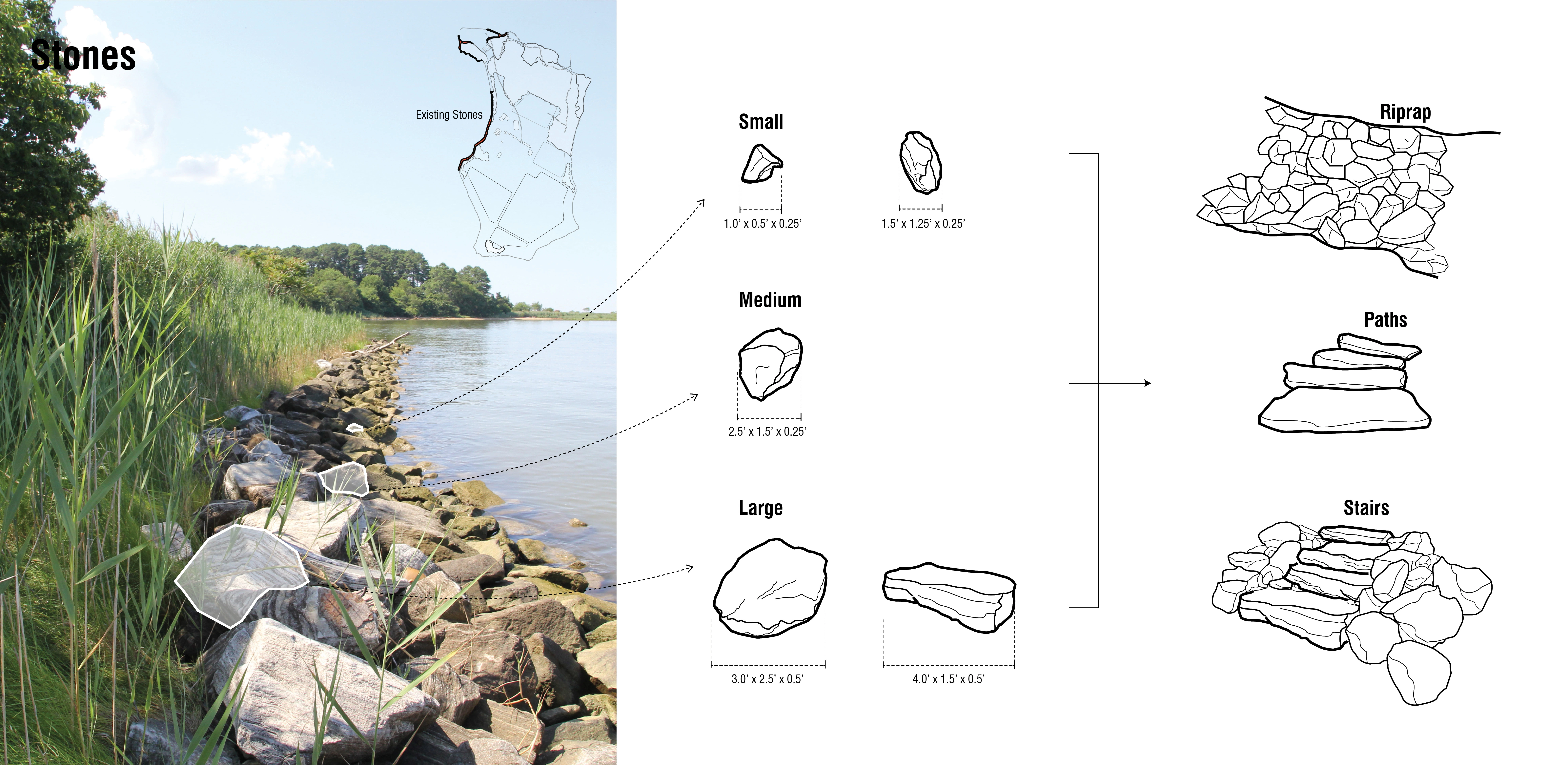
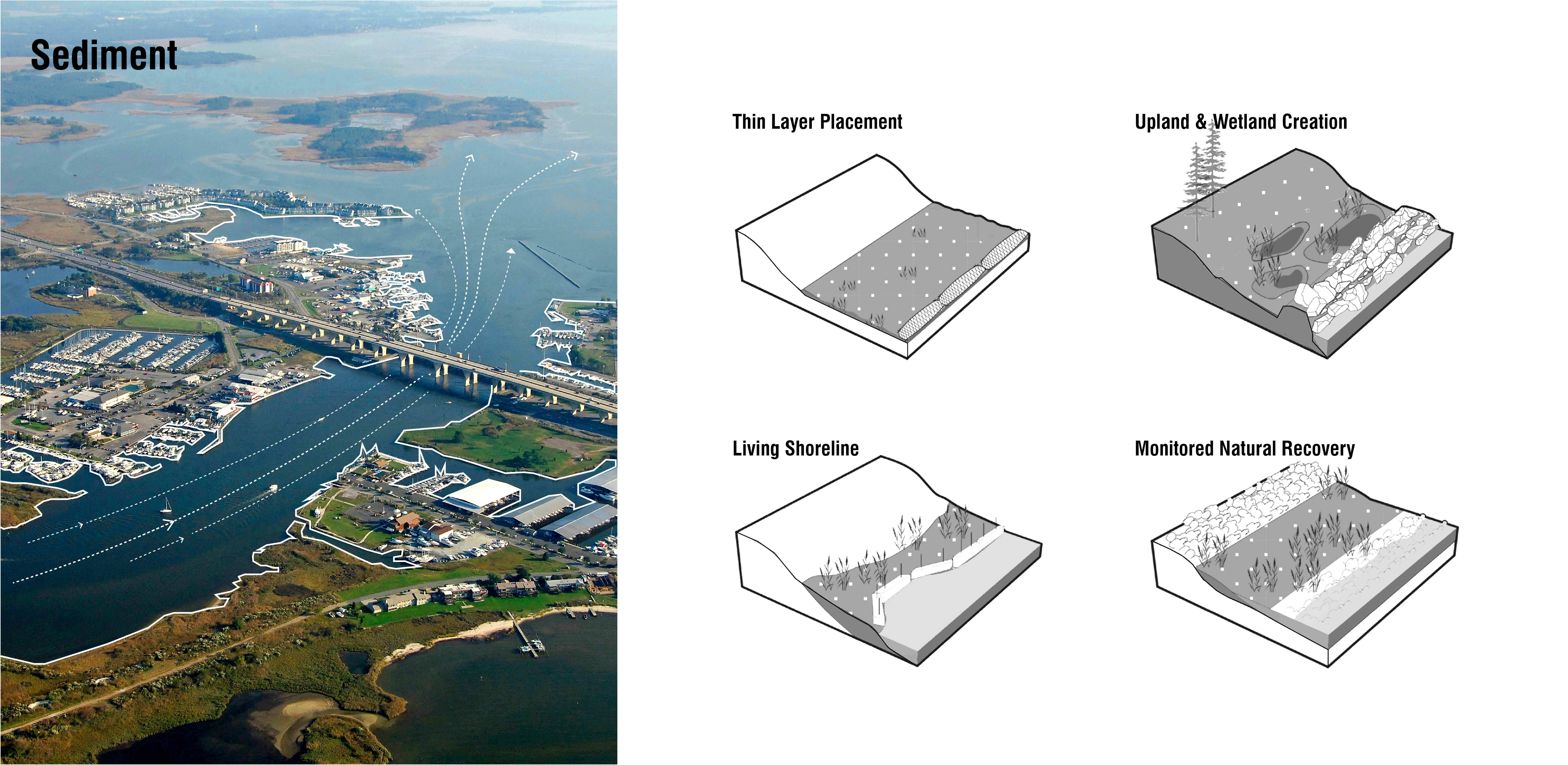
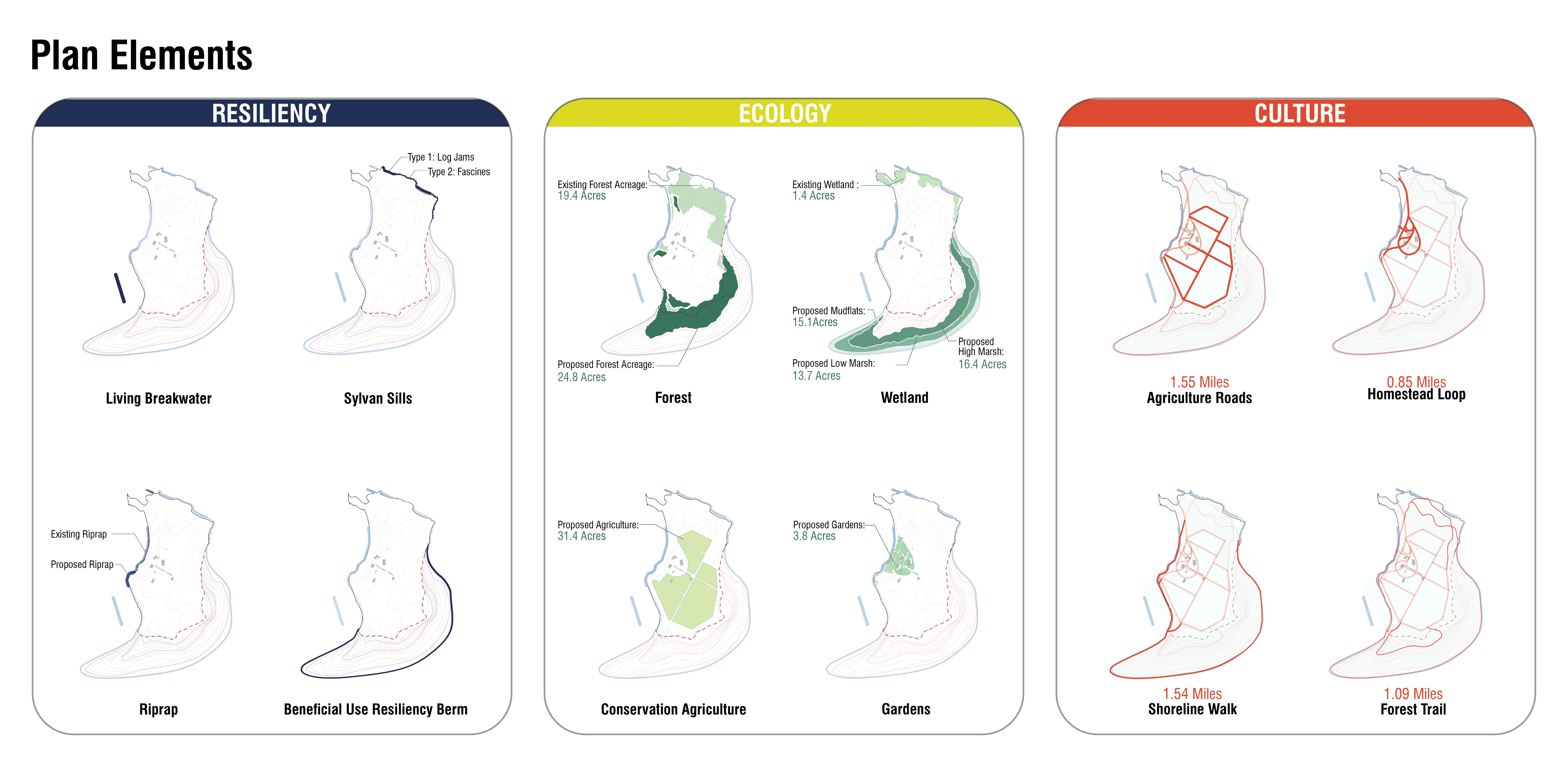
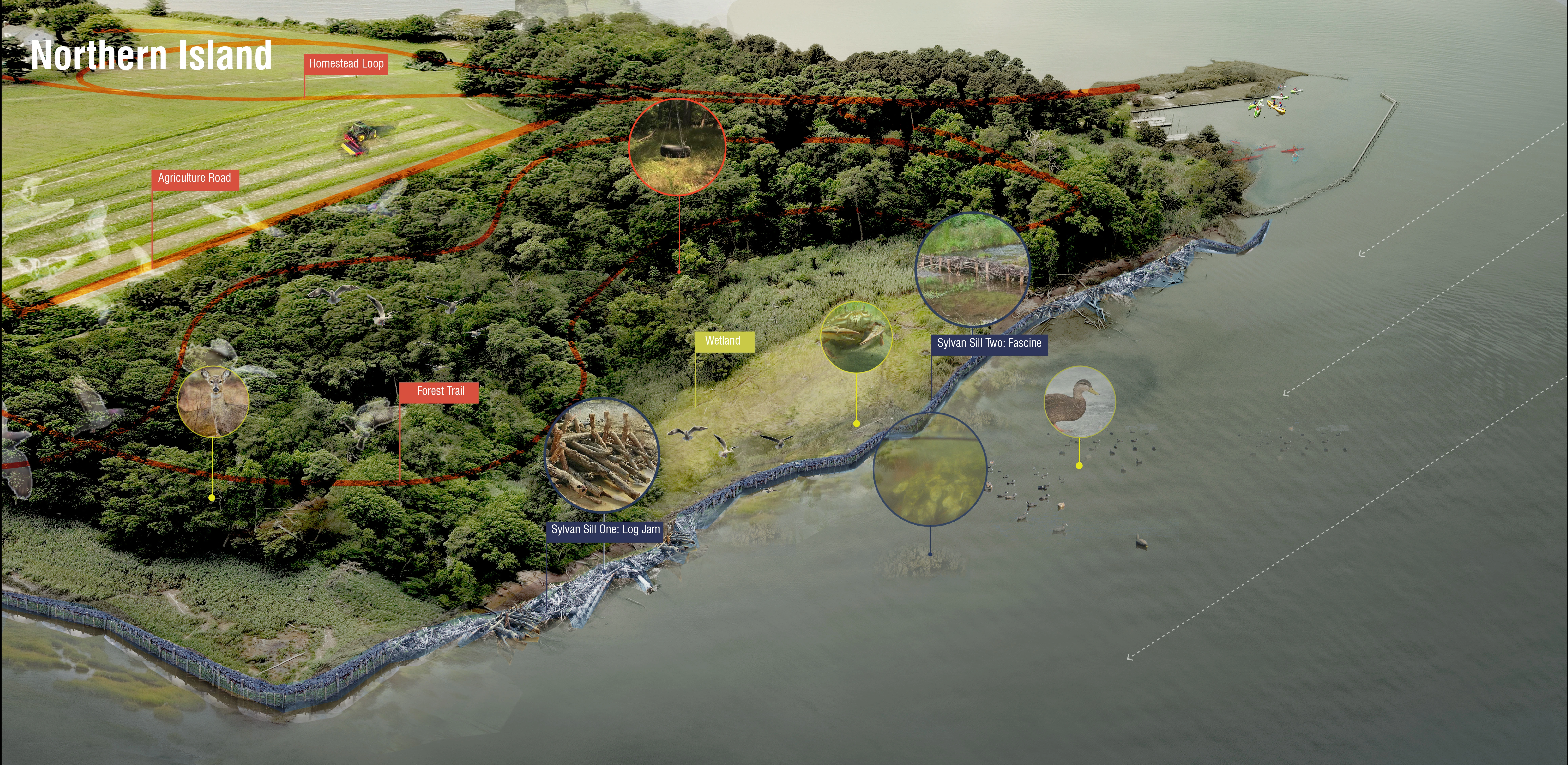
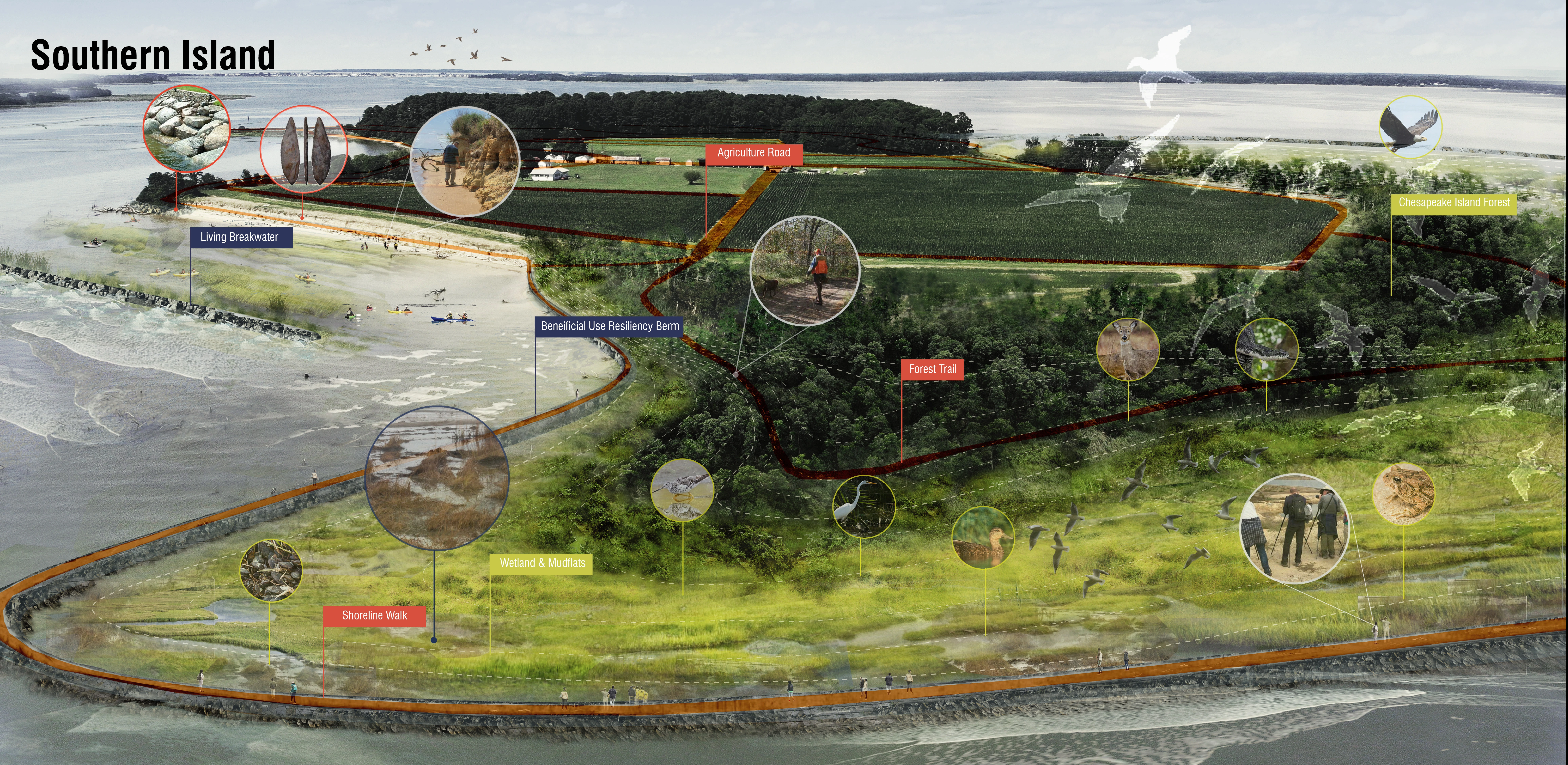
The Parsons Island Conservation and Regeneration Plan thus prioritizes the use and simple reconfiguration of existing local materials to achieve desirable outcomes that are contextually-relevant, cost effective, modular, and scalable. This approach focuses on three primary material types found on or adjacent to Parsons Island – sticks, stones, and sediments. Fallen trees including trunks, roots wads, and branches that have succumbed to wind and wave driven erosion will be relocated and reconfigured as ‘sylvan sills’ serving as wave attenuating and sediment catching features that also provide new aquatic habitat in the nearshore of the northern portion of the island adjacent to the existing stand of forest habitat and wetlands where wave energy and erosive forces are at their lowest. This stick strategy includes two types of ‘sylvan sills’ – log jams for the more highly eroded stretches of forested shoreline and fascines for the interface between wetlands and water. Along the southwestern shoreline where high intensity waves and erosion have exposed the islands pre-native artifacts for discovery, a stone strategy includes riprap, both repurposed and introduced, that will provide not only coastal protection, but also opportunities for accessibility and habitat enhancements via stone stairs and textured planting pockets. Riprap and engineered ecoblocks will also be combined to create a living breakwater in the offshore environment that aims to protect the island from continued erosion while preserving the visibility of its cultural resources and creating opportunities for public education and interpretation. Parsons’ sediment strategy will leverage dredged material from the nearby Kent Narrows waterway, which must be excavated every three years to maintain navigable depths at the expense of state taxpayers because it is not a high-volume shipping channel eligible for large federal funding. Repurposing this sediment to regenerate a portion of the island’s original footprint including new mudflats, SAV beds, tidal marshes, and island forest will nearly double the total acreage of habitat at Parsons from 78 acres to 145 acres, provide enhanced coastal resilience for land leeward of the island in Eastern Bay, and offer a cost-effective way to manage local sediment balances in the larger basin.
These integrated stick, stone, and sediment strategies will create a series of richly textured and high performing landscapes that reveal and enhance the islands cultural, ecological, and resiliency assets. A network of connected trails and interpretive elements including shoreline paths, forest walks, agricultural roads, and a homestead will weave together these quintessentially Chesapeake experiences creating a one-of-a-kind public landscape that sets a new precedent for conservation and regeneration in the region.
A CATALYST FOR COLLECTIVE IMPACT
The ambitious and collaborative Parsons Island Conservation and Regeneration Plan presents a generational opportunity to ensure the island’s priceless cultural artifacts, vital habitats, and essential landscape infrastructure benefit the public in perpetuity. The importance of these features and the consequences of doing nothing have catalyzed an evolving and growing group of conservationists, researchers, designers, engineers, and government agencies who are working together with the property owners of Parsons Island to advance the plan incrementally and establish new partnerships for collective action. Plan implementation is anticipated to occur in parallel phases with simultaneous actions and asynchronous outcomes influenced by regulatory, financing, and technical drivers. The Parsons Island Conservation and Regeneration Plan lays a groundwork of possibilities by collaboratively navigating the complex ecological, economic and regulatory context of the bay and setting an example for what could (and perhaps should) be done with the dwindling number of small, yet valuable, islands in the region. -
- Isaac Hametz - Principal
- Jeff Dube - Associate Landscape Architect
- Elaine Ku - Associate Landscape Architect
- Binyu Yang - Landscape Designer
- Jiali Li - Landscape Designer
- Sean Burkholder - Assistant Professor/Design Research
- Walter Dinicola - Principal Engineer/Marine Engineering
- Darrin Lowery - Archeologist
Advertisement
Related Awards

Honor Award, Analysis & Planning
A Cultural Approach: The Fort Peck Tribes Hazard Mitigation Plan
In collaboration with the Fort Peck Assiniboine and Sioux Tribes, EPA, and FEMA, the Fort Peck Tribes Hazard Mitigation Plan (HMP) adopts a culturally responsive approach to hazard mitigation planning that features connection to place.

