.webp?language=en-US)


VanPlay: Parks and Recreation Vision Plan
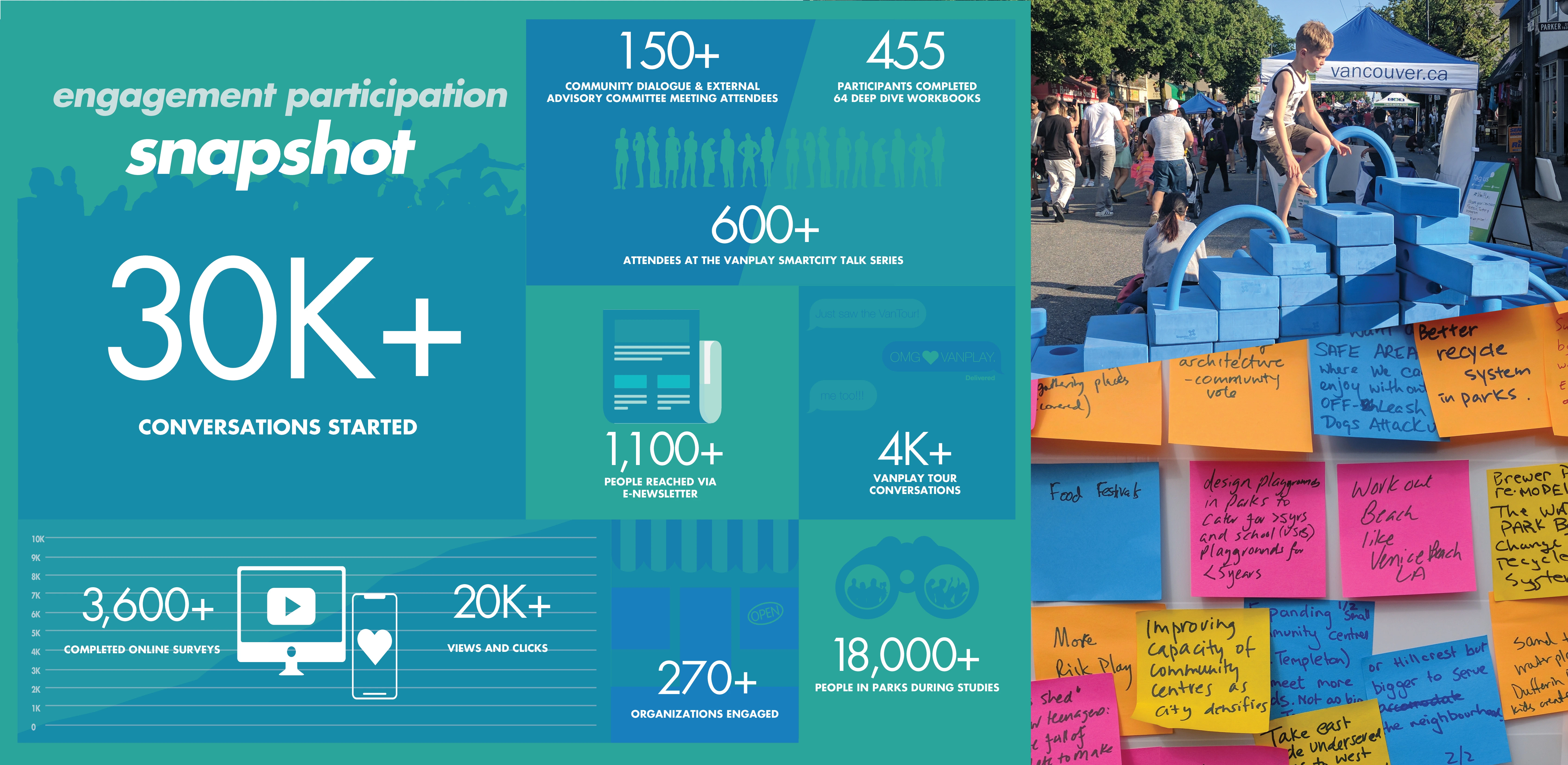
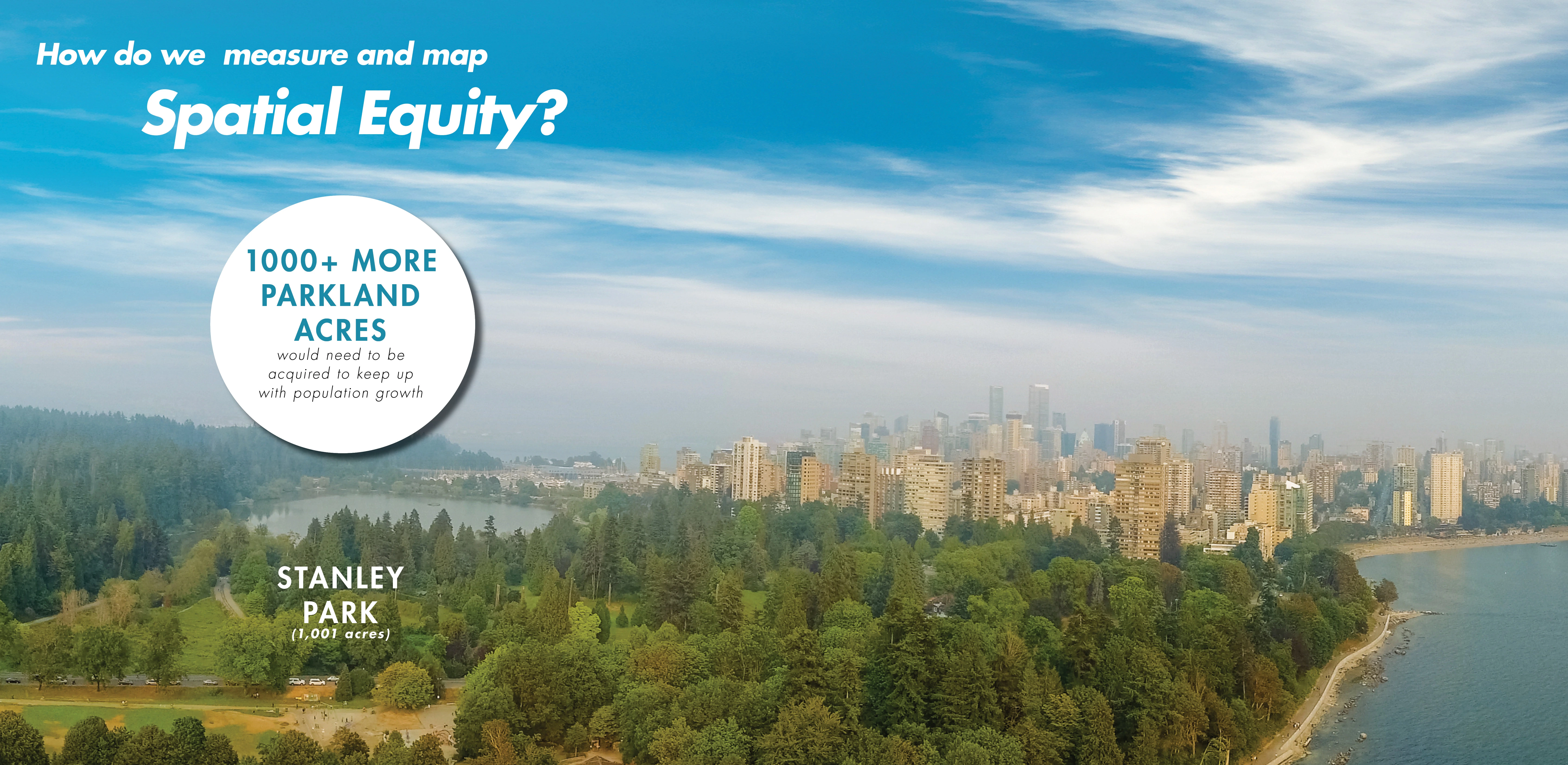
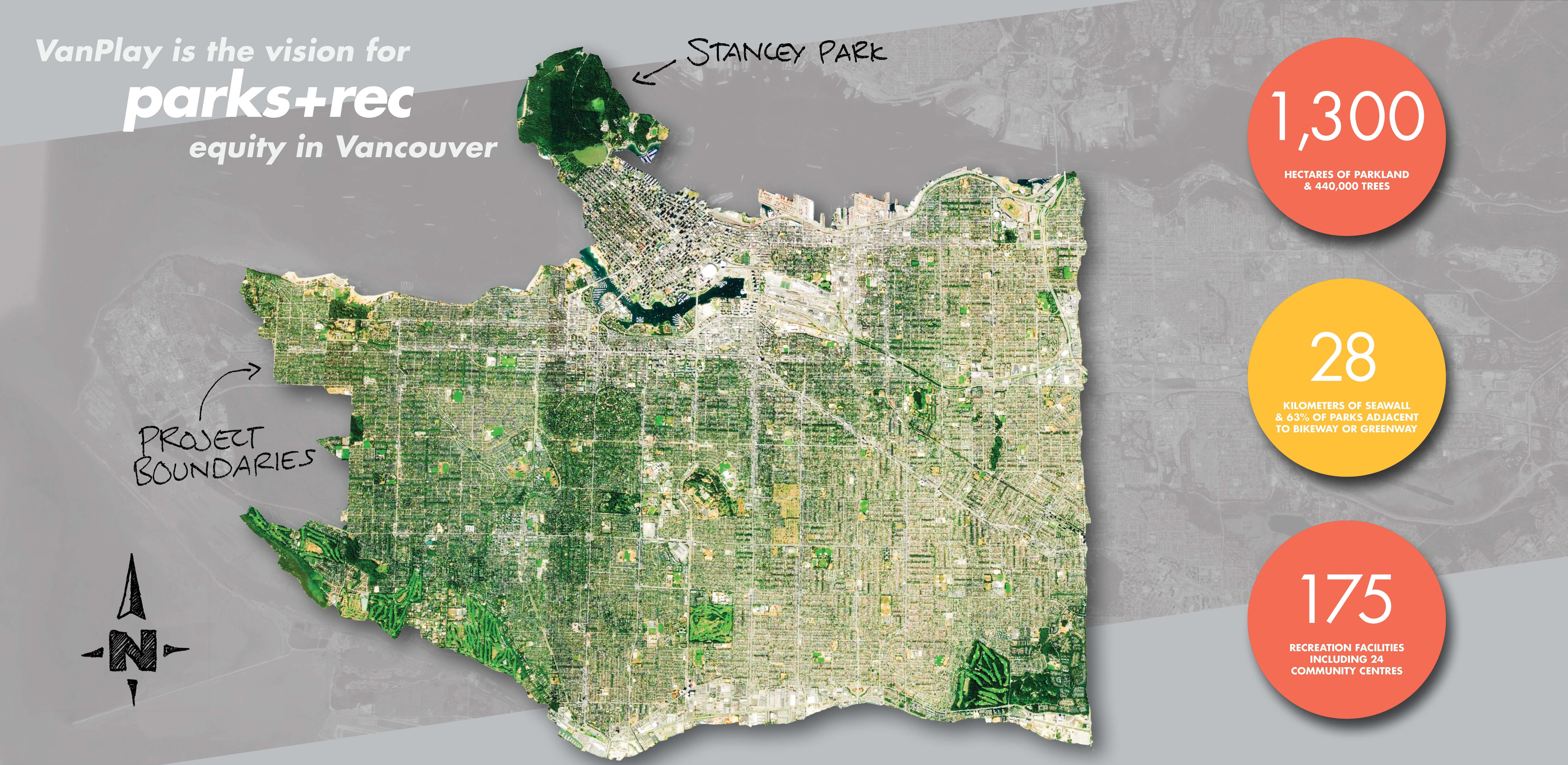
Vancouver boasts 631,000 residents speaking 191 languages, yet the city’s areas for recreation—some 3,200 acres of parks including the 1,001-acre Stanley Park—manage to respond to unique needs of individuals and specific groups through the VanPlay Vision Plan. Analysis of more than 30,000 community conversations led to a universal acceptance of a 100-year plan with something for every constituent, based off of information gleaned from a spatial equity tool that identified priority areas of intervention to approach parity in resource distribution. Overlaid onto this analysis and accommodated into the future plan is an understanding that climate change may reduce available land by 11 percent, underscoring the importance of interconnections between existing resources to capitalize on expanded regional access for Vancouver’s distinct constituencies.
Awards Jury
-
“In addressing spatial equity, VanPlay recognizes the inherent privilege some populations have to enjoy parks and recreation and provides added support and welcome to populations without that privilege.”
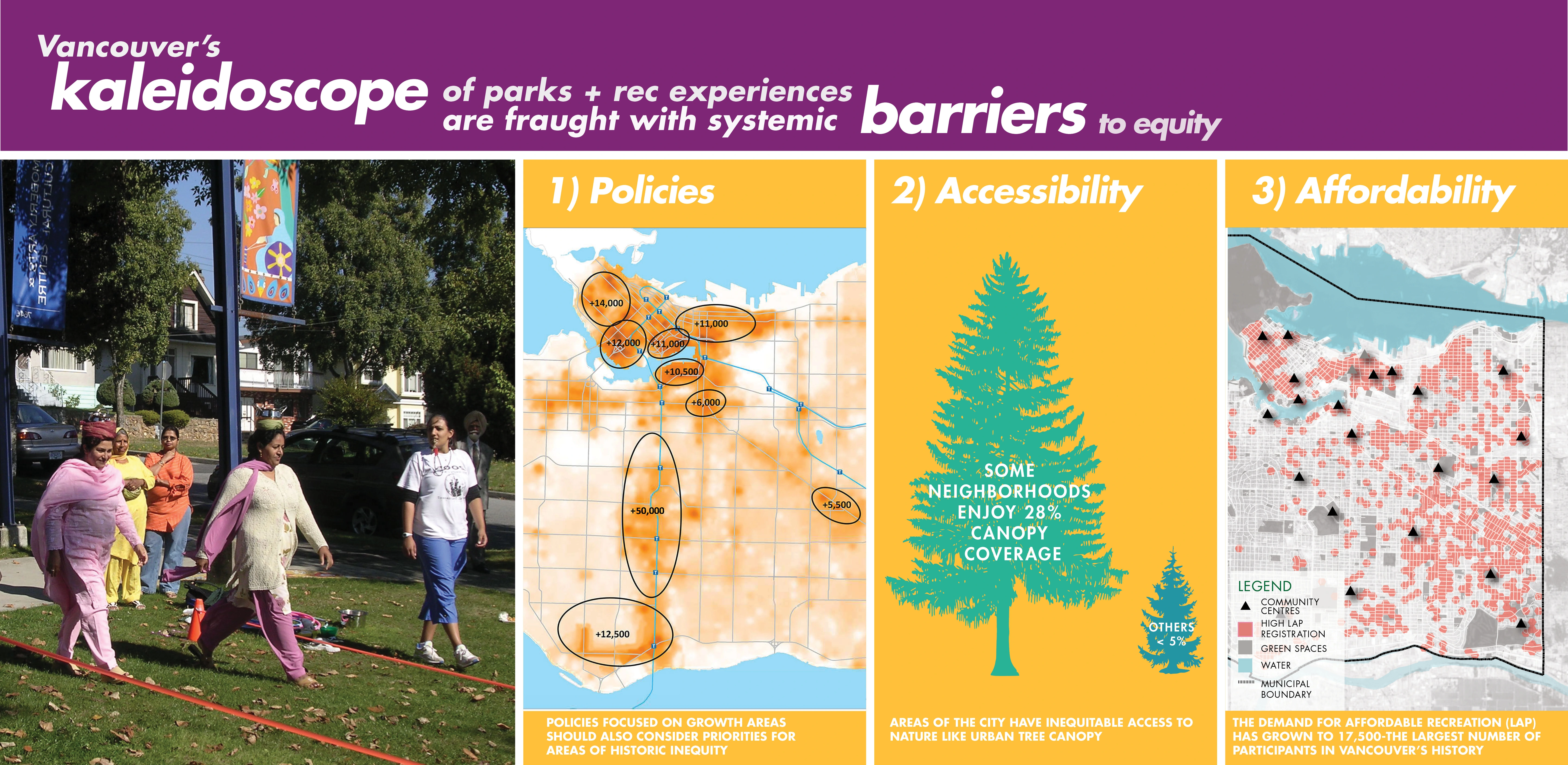
Vancouver embodies diversity in the 191 languages spoken by the city’s 631,000 residents. This diversity is reflected in the kaleidoscope of experiences available throughout 1,300 hectares of parkland, 28 kilometers of seawall, and network of 175 recreation facilities. However, when analyzed these exceptional opportunities to recreate are fraught with systemic barriers and vulnerabilities to equity, most notably for the 120,000 Vancouverites who experience poverty.
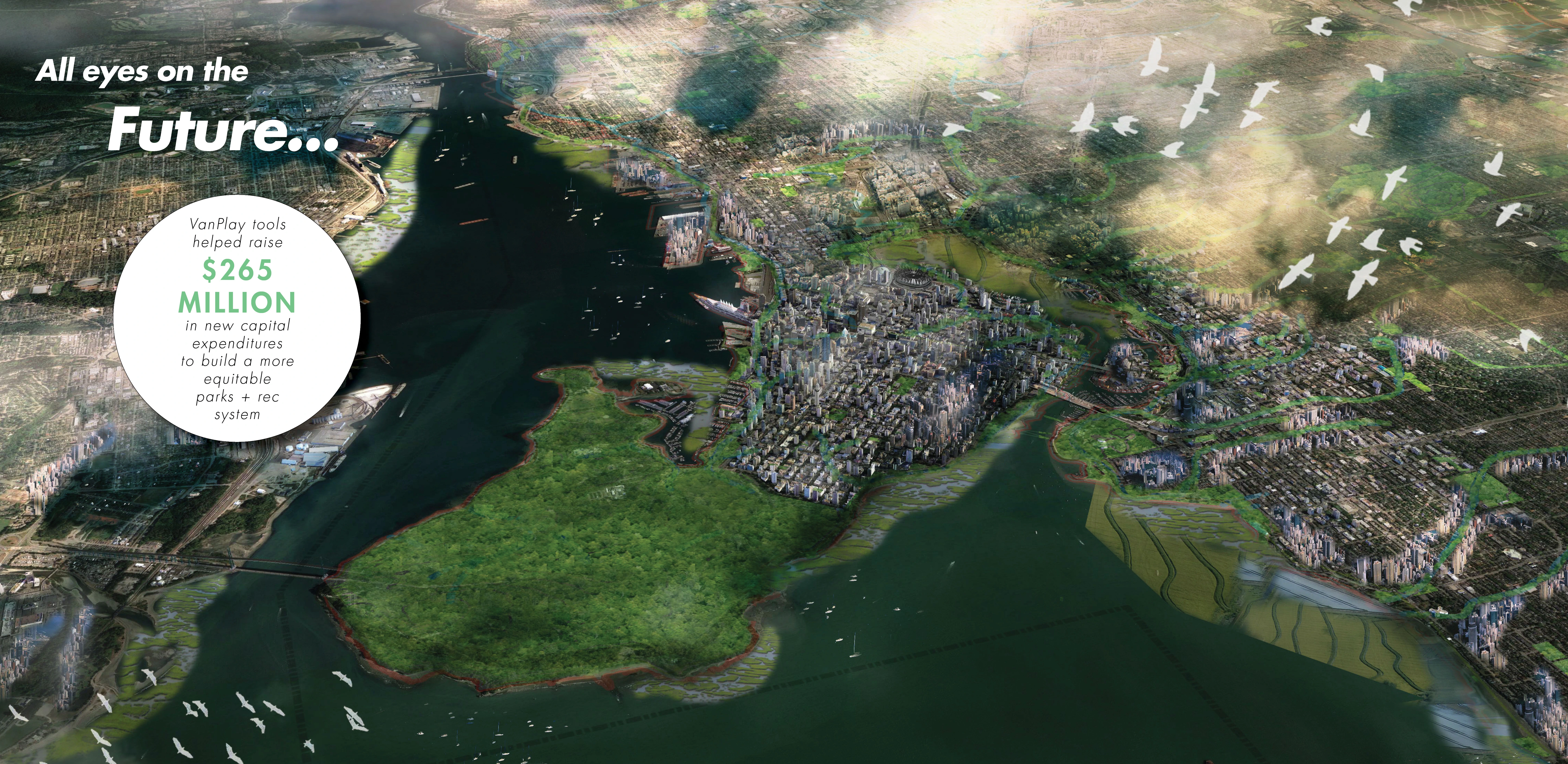
Undertaking the first citywide parks and recreation study in 25 years, the landscape architect led a multi-disciplinary team to craft a data-driven plan that puts community priorities of equity, asset renewal, and connectivity at the core of the city’s decision-making. Informed by over 30,000 community conversations, the unanimously-adopted plan has already garnered $265 million in new capital expenditures to provide more people the opportunity to connect to nature and shift the levers of power to bridge systemic barriers to spatial justice in Vancouver. -
PROJECT GOALS
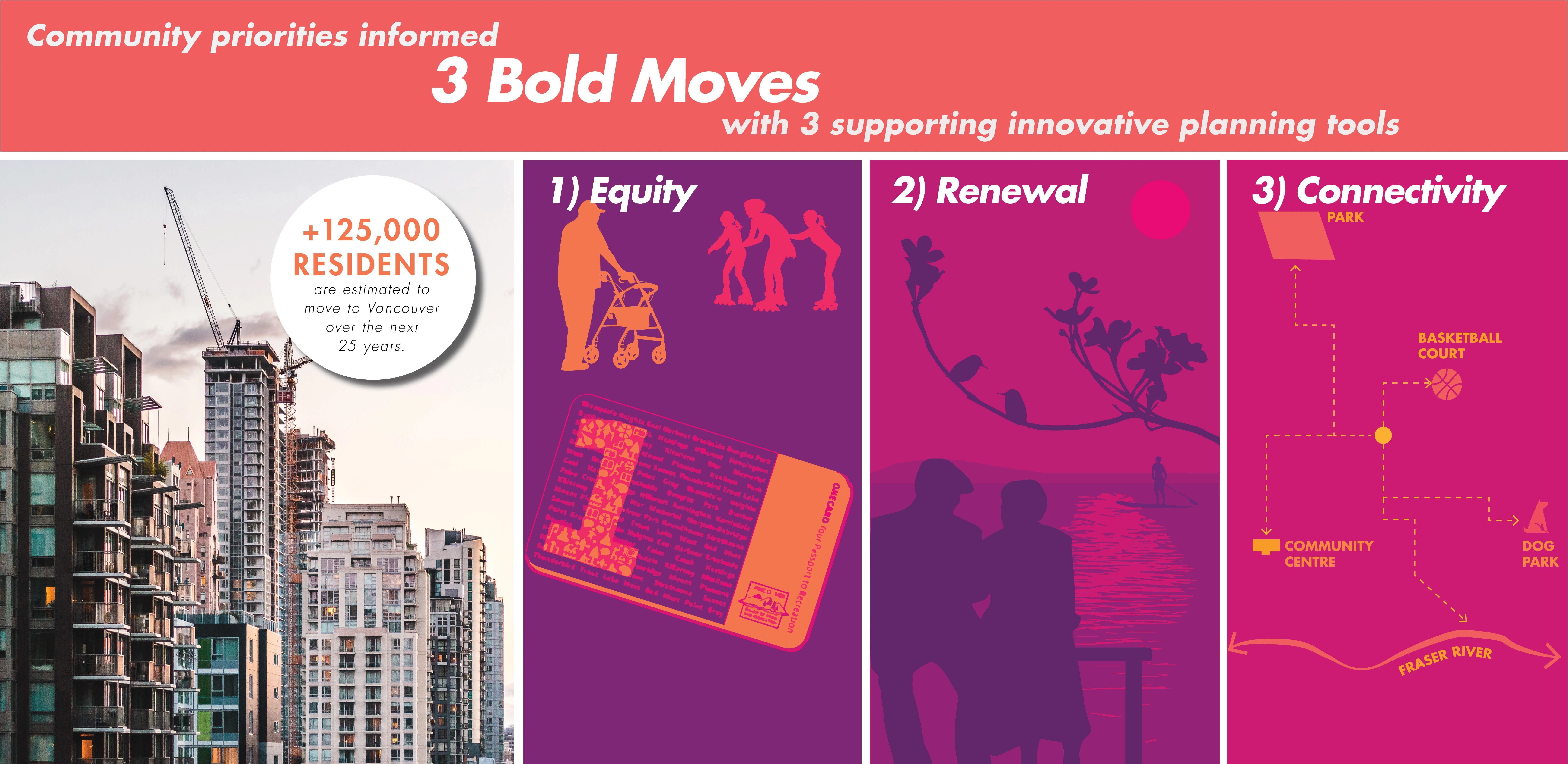
VanPlay is centered around three Bold Moves that support the pursuit of equity, connectivity, and access to parks and recreation for the current population and the 125,000 additional city residents anticipated by 2040. As a 44-square-mile land-locked city, Vancouver would have to add a park the size of Stanley Park (1001 acres) to keep up with the projected densification. Helping to address this future and lift up areas of historic inequity, the Bold Moves include three innovative planning tools:
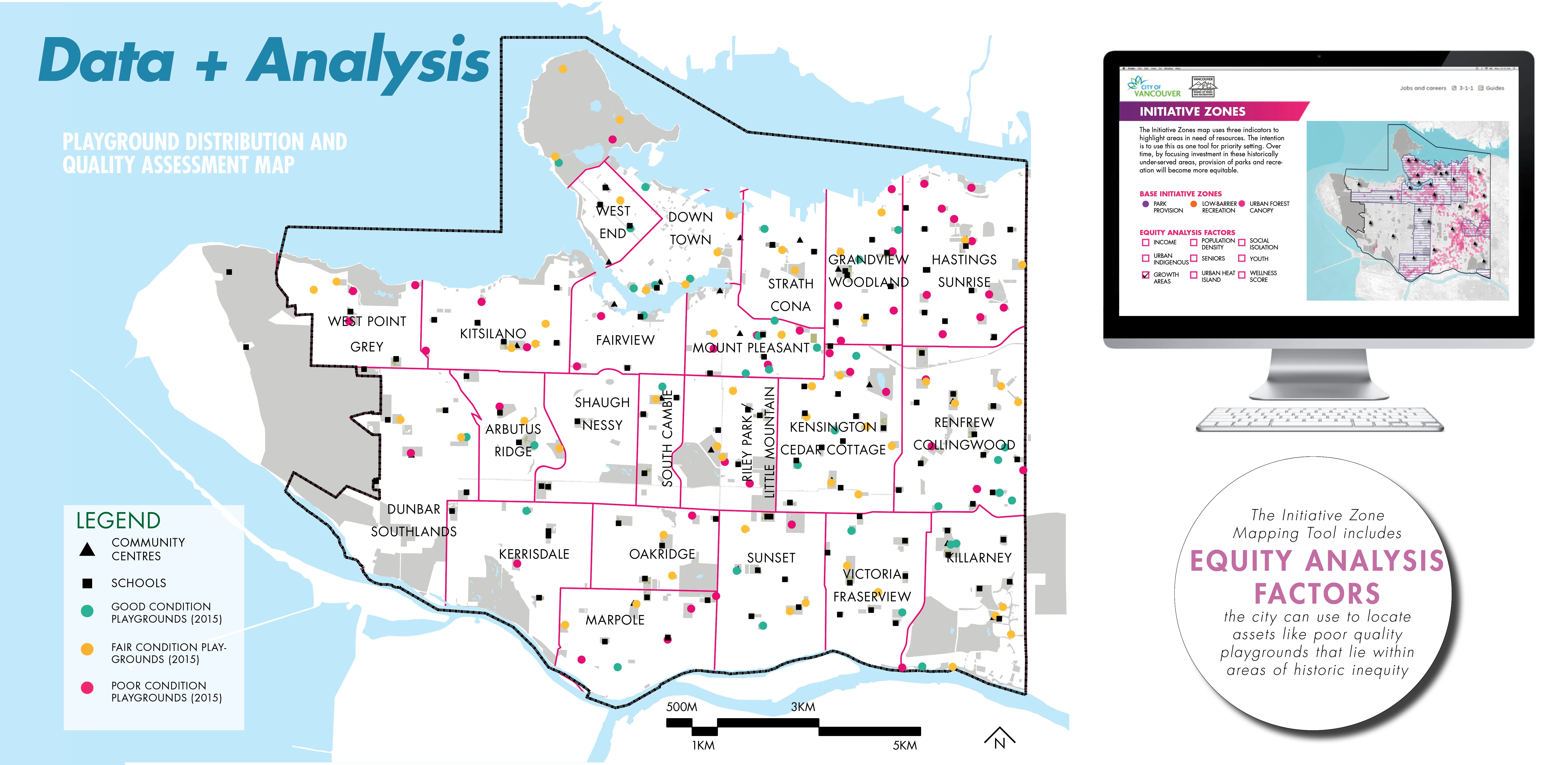
1. Initiative Zone Mapping Tool highlights areas of the city in need of resources and includes equity analysis factors so that projects, programs, and plans can be focused for more equitable provision over time.
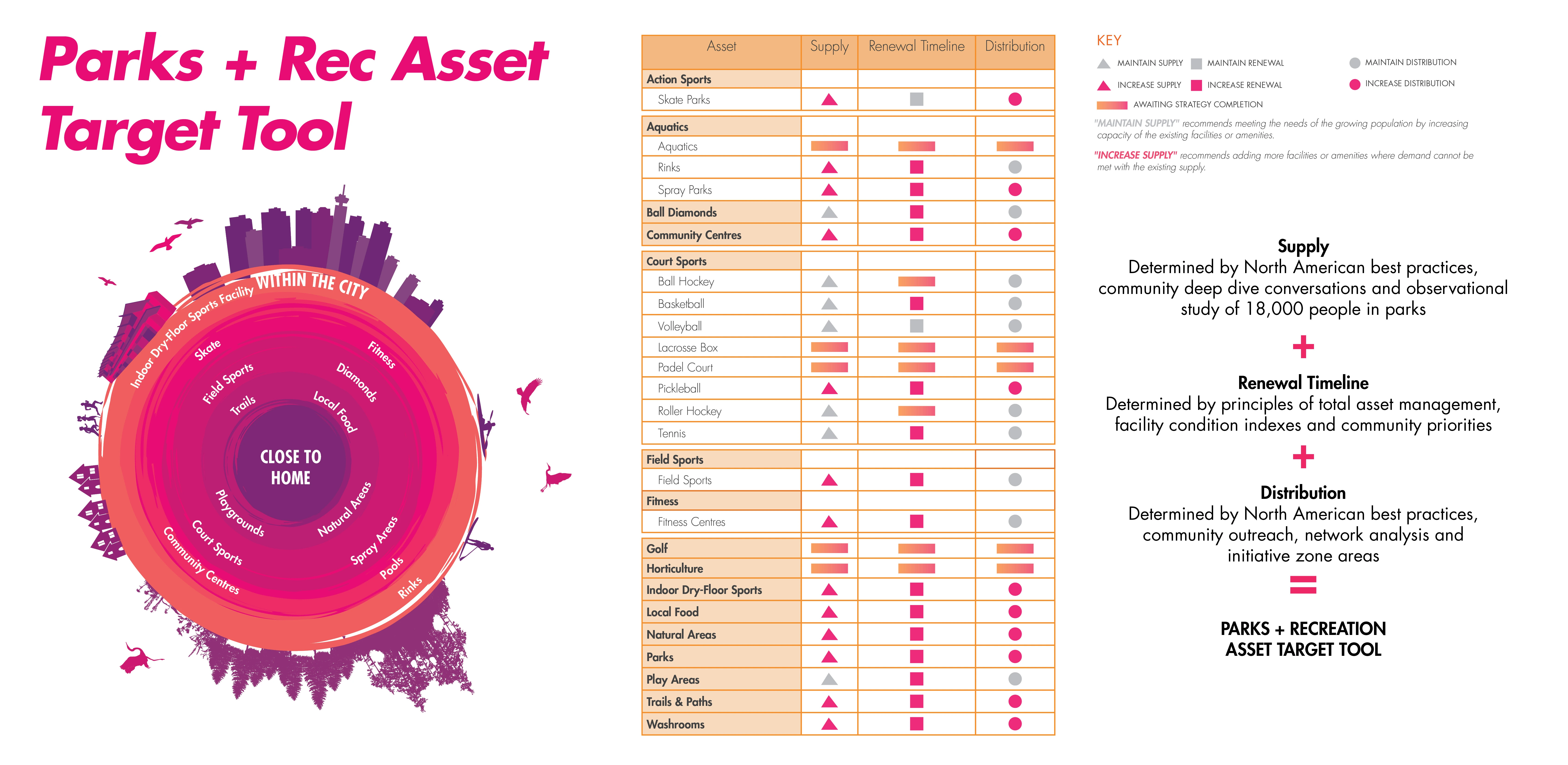
2. Parks and Recreation Asset Target Tool considers quantity, quality, capacity, and distribution of parks, natural areas and recreation facilities in the context of a growing population, deferred maintenance and limited resources.
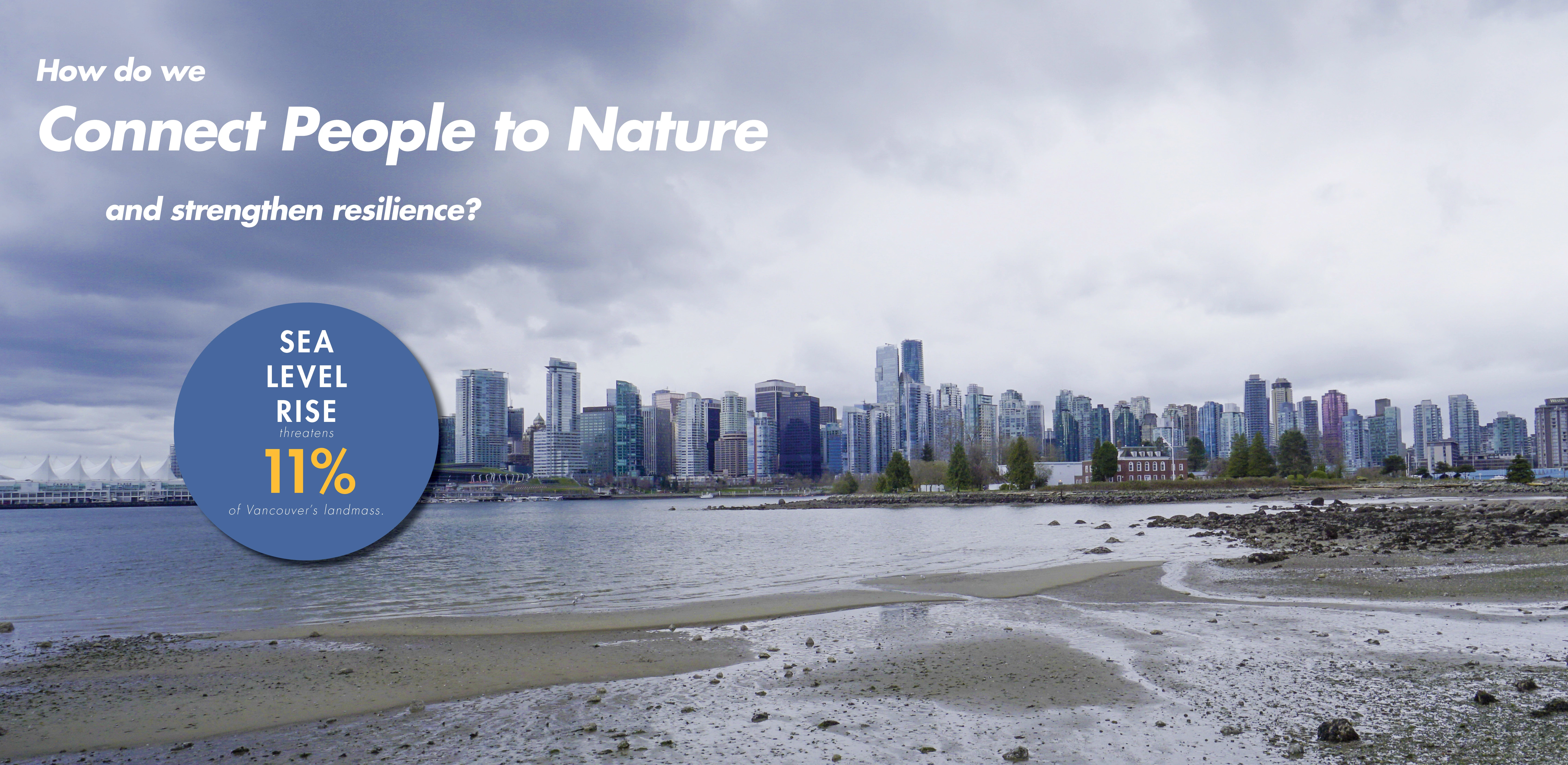
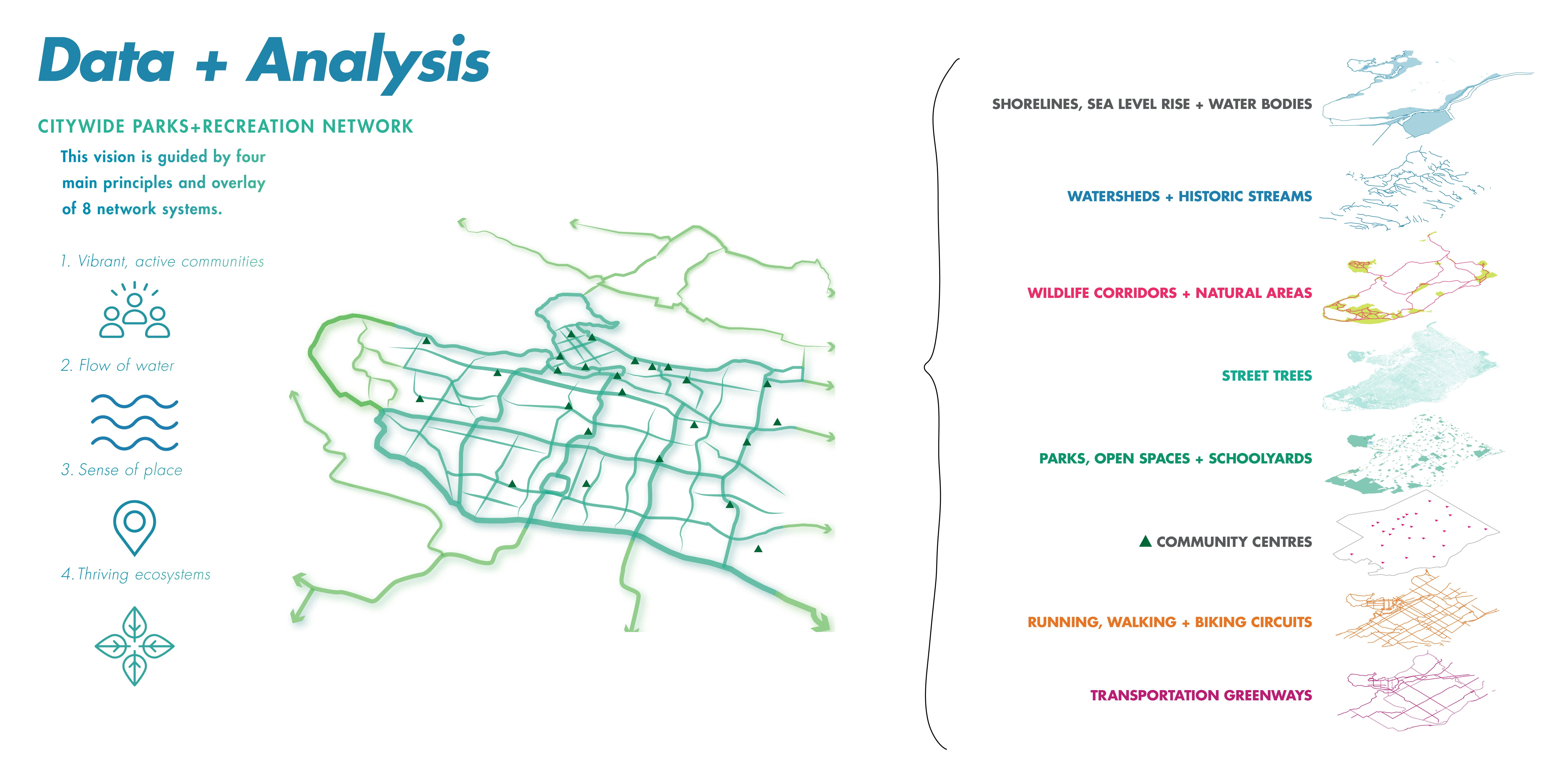
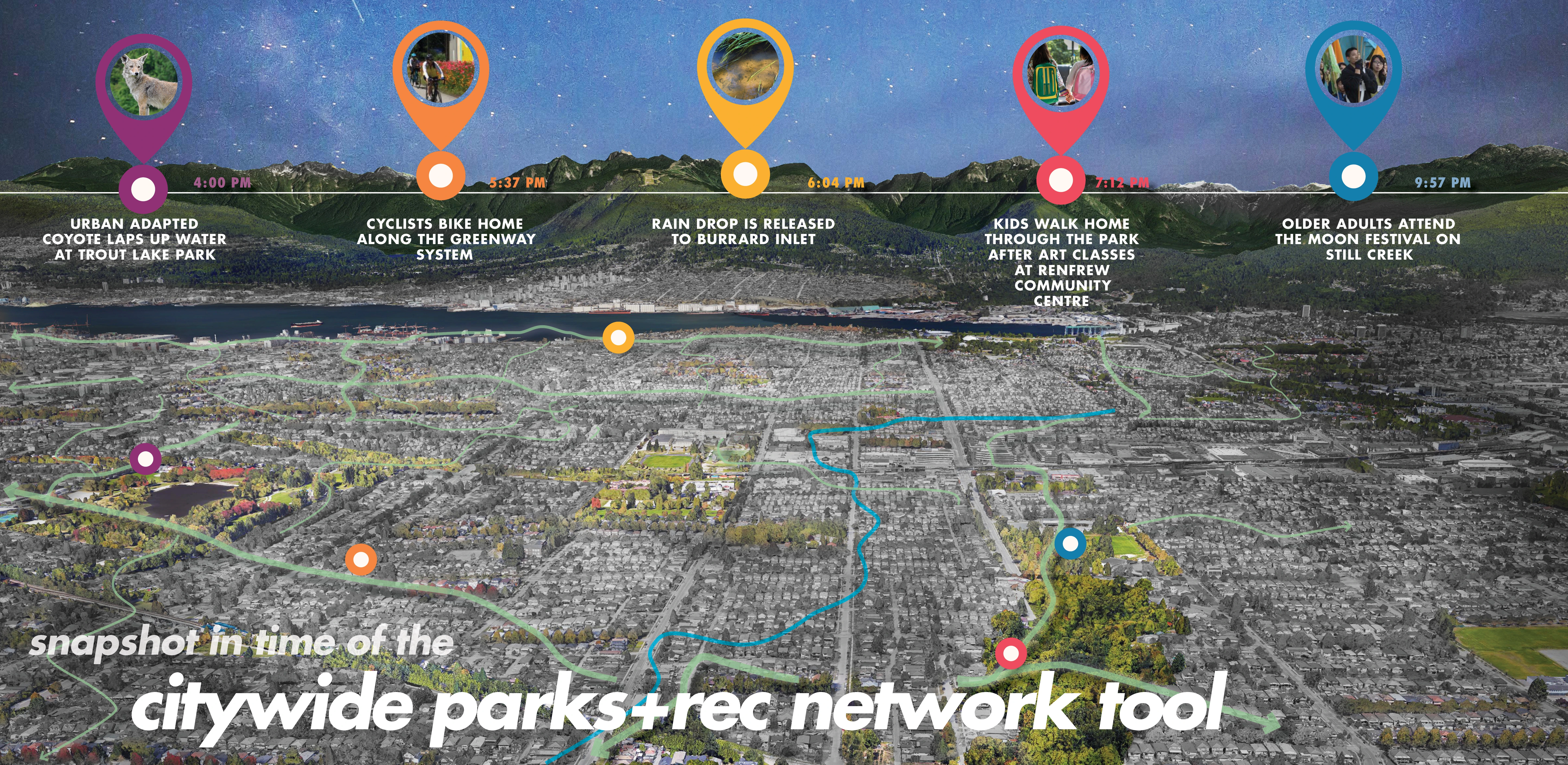
3. Citywide Parks and Recreation Network Tool conceptualizes a 100-year vision of a seamless public realm to connect places, such as community centers, trail systems and large parks together with publicly accessible waterfront lands that expand access regionally and protect ecosystems threatened by impacts of climate change.
SOCIAL DATA AND ANALYSIS SNAPSHOT
Each tool addresses a critical question for the future of parks and recreation and is informed by a strong foundation of previous plans and Vancouver-specific social demographic studies. The team conducted rigorous case studies of global best practices for parks, recreation and equity frameworks. Furthermore, a systemwide observation study (System for Observing Play and Recreation in Communities-SOPARC) took place over six weeks and documented how over 18,000 people used parks in neighborhoods of varying income and diverse backgrounds.
Using these findings and a recent park provision study, the team considered barriers to access that are not normally accounted for—such as busy street crossings, lack of public transportation, and the price of local recreation programs.
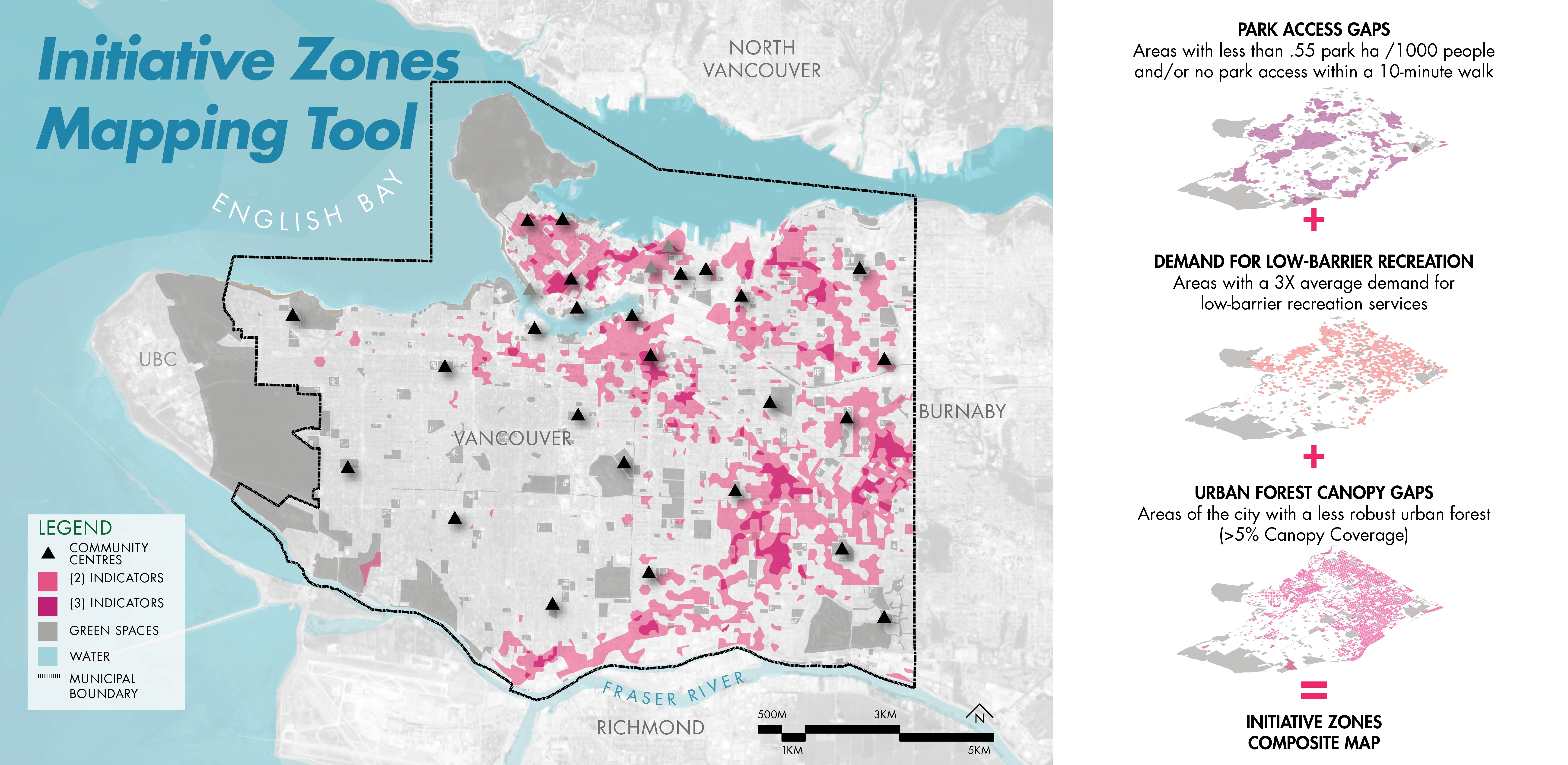
HOW DO WE MEASURE AND MAP SPATIAL EQUITY?
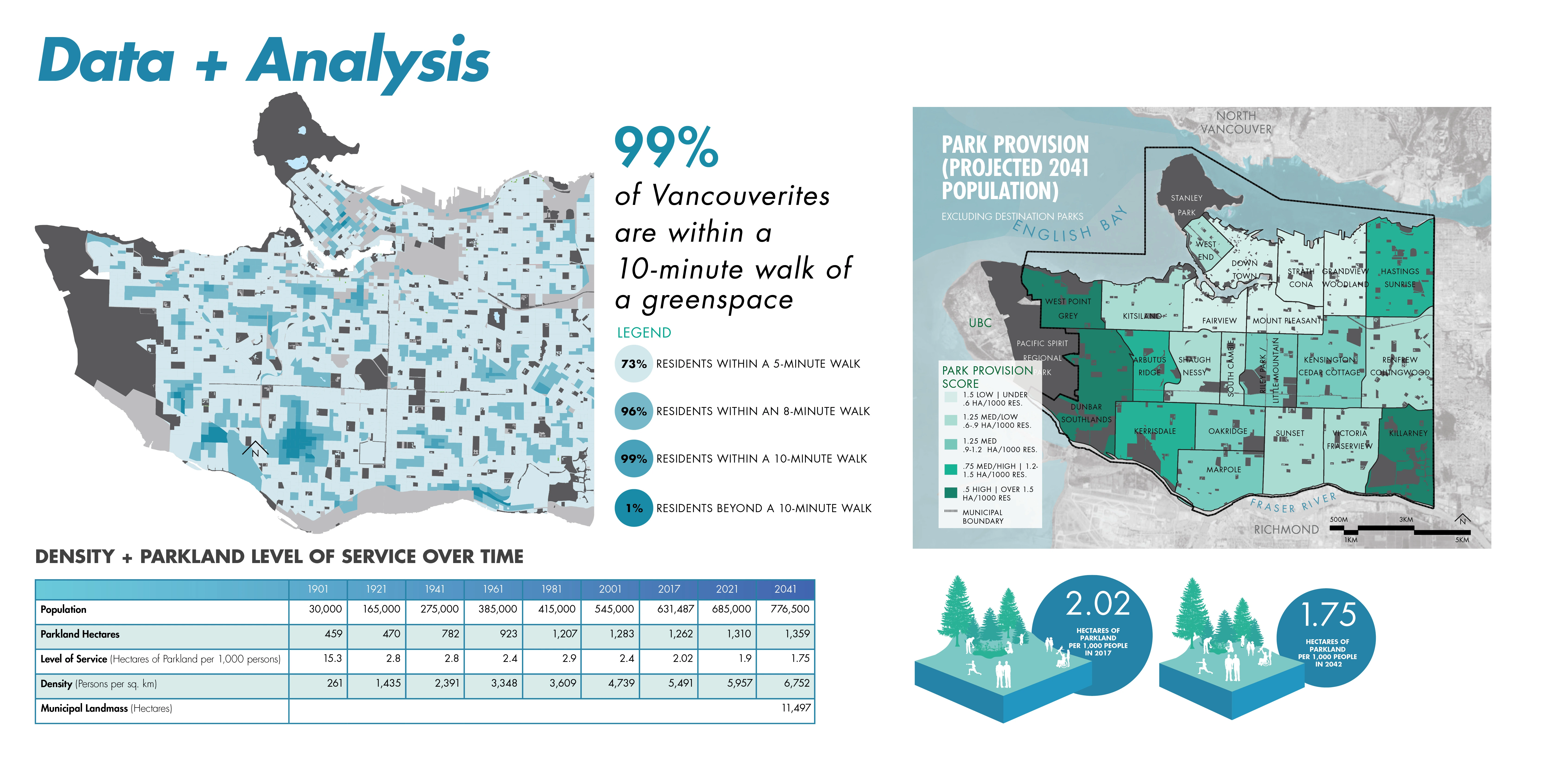
While 99 percent of Vancouverites currently live within a 10-minute walk of a greenspace, the quality and condition of these spaces vary widely, particularly in low-income communities. The Initiative Zone Mapping Tool uses three indicators which are layered atop one another at a block-scale resolution to reveal areas of the city that have historically been marginalized for provision of park space, recreation opportunity and green, leafy living environments. This inequity is systemic prejudice and has profound impacts on health and well-being, social capital, and economic development.
The spatial equity tool introduced in VanPlay is powerful in its simplicity and how clearly it shows the locations of priority areas. The areas of the city with low park space per person, that are less green, and that are screaming out for more recreation opportunities are the places where there are people living in small apartments, who perhaps do not have private outdoor space like a backyard in which to quarantine, or do not have access to shade on a hot summer day and are more likely to suffer from heat stroke.
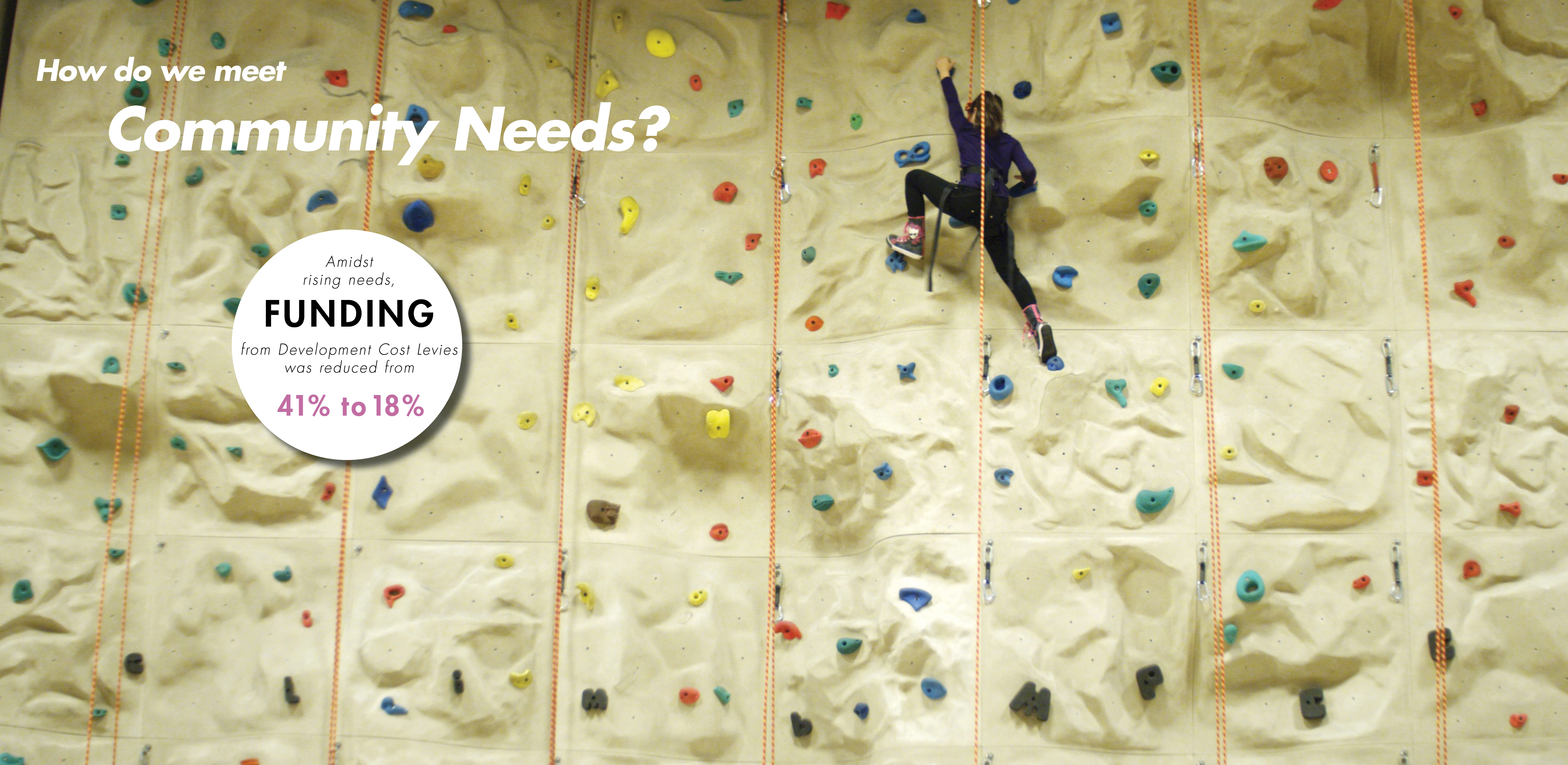
HOW DO WE MEET COMMUNITY NEEDS WHILE PRIORITIZING LIMITED RESOURCES EQUITABLY?
North American cities are struggling to keep up with community needs. In Denver for example, it would take over 400 years at the current level of funding to fill in all the missing sidewalks. Complex, long-standing factors, such as patterns of development and investment, often result in an uneven distribution of amenities across a city.
The Parks and Recreation Asset Target Tool takes stock of the city’s recreational resources (assets), which include park space, sport fields, ice rinks, and urban forests, to name a few. The tool analyzes not just their location but also their condition, renewal timelines, and considers future needs through goal setting to ensure all Vancouverites have access to excellent amenities. The planning team scoured benchmark methodologies including the Trust for Public Land’s ParkScore system as well as total asset management best practices. Coupled with the Initiative Zone Mapping Tool, the city can now triangulate which amenities need improvements in distribution and quality, and which ones are located in areas of historic inequity.
HOW DO WE CONNECT MORE PEOPLE TO NATURE AND STRENGTHEN ENVIRONMENTAL RESILIENCE?
The Citywide Parks and Recreation Network Tool conceptualizes places to play, exercise, and socialize with direct and intuitive connections for pedestrians and cyclists of all ages and abilities in and between these spaces, while providing pathways for the movement of urban wildlife and stormwater. Multiple departments collaborated together to understand how this tool could help Vancouver adapt to the impacts of climate change, including a potential 11 percent loss of the city’s landmass to sea level rise, while adding more opportunities for recreation and wellness through the city.
Because land in Vancouver can cost into the tens of millions of dollars per hectare, buying the land needed for new parks to balance the rapid growth in population is not possible. For this reason, the Network Tool provides a new conceptualization of recreational space, which includes the whole public realm—streetscapes, tree canopy, schools, rooftops, interiors of buildings—with a call for integrated blue-green infrastructure systems that can provide resilience in the face of climate change and global pandemics. From a public health perspective, this network extends into Equity Initiative Zones and helps connect those communities, which typically experience transportation barriers and public health inequities, with more opportunities for walking and cycling to greenspace destinations as part of their daily lives.
30,000 COMMUNITY CONVERSATIONS
Facing a community burned-out with planning fatigue, VanPlay sparked thousands of conversations about the future of parks and recreation using a suite of tools including:
-- Inclusive plan graphics that intentionally represented people of different ages, sizes, gender identifications and abilities;
-- Videos highlighting the sights, sounds and energy of a day in the life of the Vancouver’s parks and recreation system and helped garner 1 million digital impressions;
-- A VanTour that transported an interactive imagination playground to diverse neighborhoods through the city and connected with 4,000 people;
-- A series of Smart City community lectures delving into topics including spatial equity;
-- Three public online surveys that informed and verified the development of the Bold Moves;
-- Deep Dive Workbooks conducted by 270 community-based organizations; and
-- A workshop to decolonize the vision plan language with the city’s Reconciliation Planner (VanPlay dovetailed with the city’s ongoing Reconciliation work with Musqueam, Squamish, and Tsleil-Waututh First Nations). The process of decolonization helps reveal hidden language biases.
RESULTS
VanPlay’s Bold Move tools are unique in that they combine a focus on access to parks and recreation with the acknowledgement of systemic prejudice and inequity in the planning of these spaces. The tools are transparent, logical, and approved policy that is ready to be used to prioritize resources.
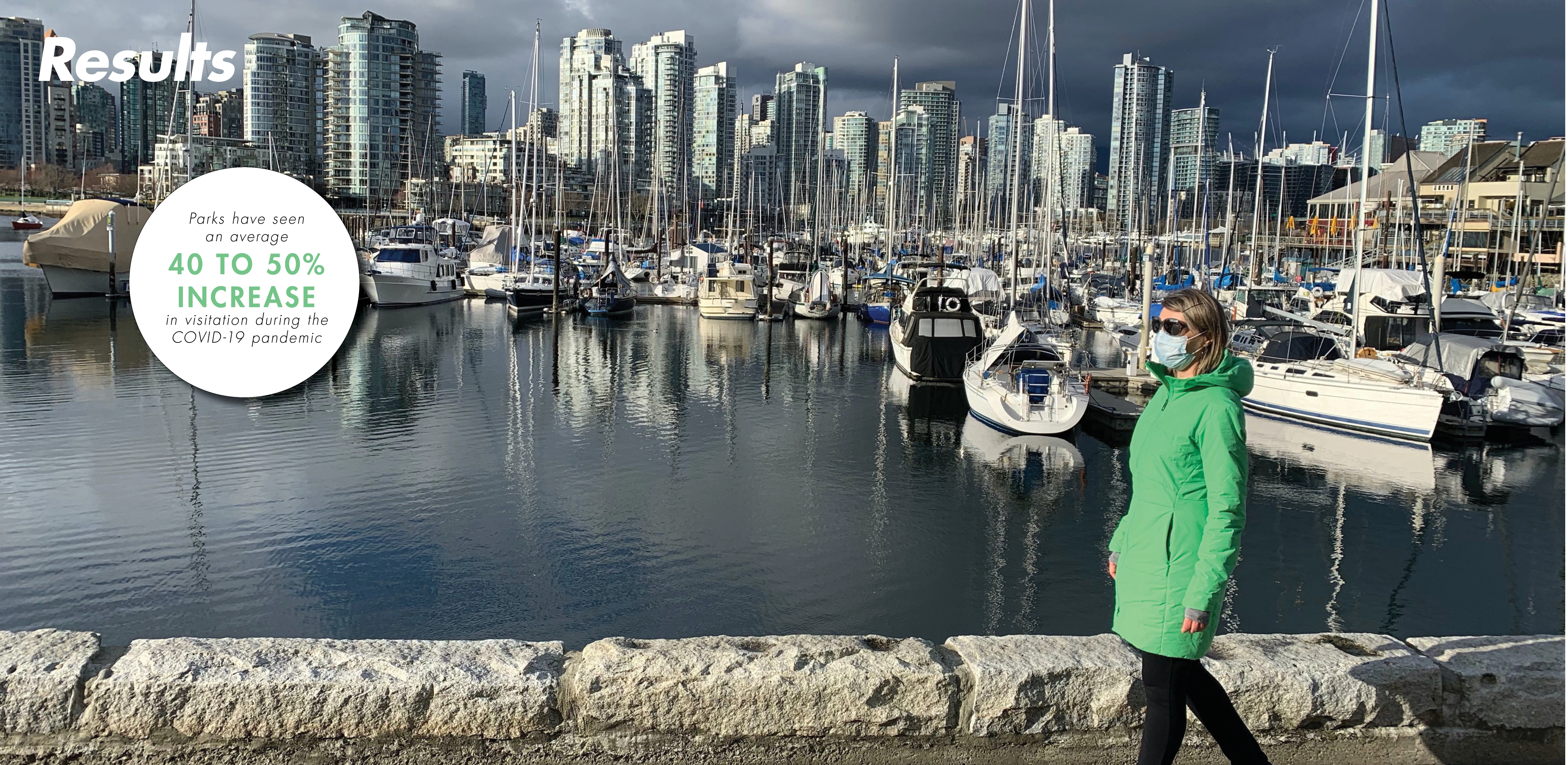
The tools are currently being used in response to the COVID-19 pandemic as parks and open spaces are more in demand than ever. British Columbia’s parks have seen an average of 40 to 50 percent more visitors than would be typical at this time of year. As recovery funding flows in, the city has been able to pilot quick responses, like opening 22 kilometers of “slow streets,” and is using the VanPlay plan to prioritize public spending.
VanPlay’s Bold Move tools are only a start for addressing systemic inequities in planning. Especially now, as people seek open green spaces more than ever and recovery funding is beginning to reach cities around the world, it is absolutely critical to have transparent processes and well-articulated values when the call for “shovel ready” projects comes in. This project redefines parks and recreation planning standards and delivers model tools for cities to imagine, plan and provide more equitable park and recreation access to their communities. -
- Kurt Culbertson (Principal), Amanda Jeter (Project Manager), Hadley Peterson (Project Planner), Cali Pfaff (Project Landscape Architect), Nino Pero (Graphic Designer) - Design Workshop, Inc.
- Modus Planning and Engagement, Lees Landscape Architecture, AES, Urban Design 4 Health, HCMA Architects, Dr. Val Schaefer, Janine De La Salle, ETM Associates, Golder Associates, Licker Geospatial Consulting Co. - Consultants
- City of Vancouver and Vancouver Board of Parks and Recreation - Client
- Malcolm Bromley, Shauna Wilton, Dave Hutch, Doug Shearer, Katherine Howard, Howard Normann, Donnie Rosa, Tina Mack, Godfrey Tate, Michelle Larigakis - Vancouver Board of Parks and Recreation Members
Advertisement
Related Awards

Honor Award, Analysis & Planning
A Cultural Approach: The Fort Peck Tribes Hazard Mitigation Plan
In collaboration with the Fort Peck Assiniboine and Sioux Tribes, EPA, and FEMA, the Fort Peck Tribes Hazard Mitigation Plan (HMP) adopts a culturally responsive approach to hazard mitigation planning that features connection to place.


Related Articles
Landscape Architecture Magazine
LAM Wins Five ASBPE Awards
Landscape Architecture Magazine earned national and regional honors for editorial excellence, publication design, and profile.
Jun 1 2026