.webp?language=en-US)


Eco-Agro-Urbanism: Envisioning a Productive Urban Future for Villa Nueva, Guatemala
Zihan Zhu, Student ASLA; Xiaofan Wu, Student ASLA; Xu Han
Just southwest of Guatemala City lies Villa Nueva, where historically agricultural lands are rapidly urbanizing. A verdant plot of underutilized public land divides the city from low-income to the west, and middle income to the east, but could be the site of economic and ecological reconnection with the development of a new, central, green corridor. The project envisions planned growth of resident-built dwellings around cooperative markets, weaving the built landscape into the site’s existing ecology. Through managed cultivation of diverse edible species, this corridor has potential to become a productive public amenity that links adjacent communities through a landscape they have helped to revitalize.
Awards Jury
-
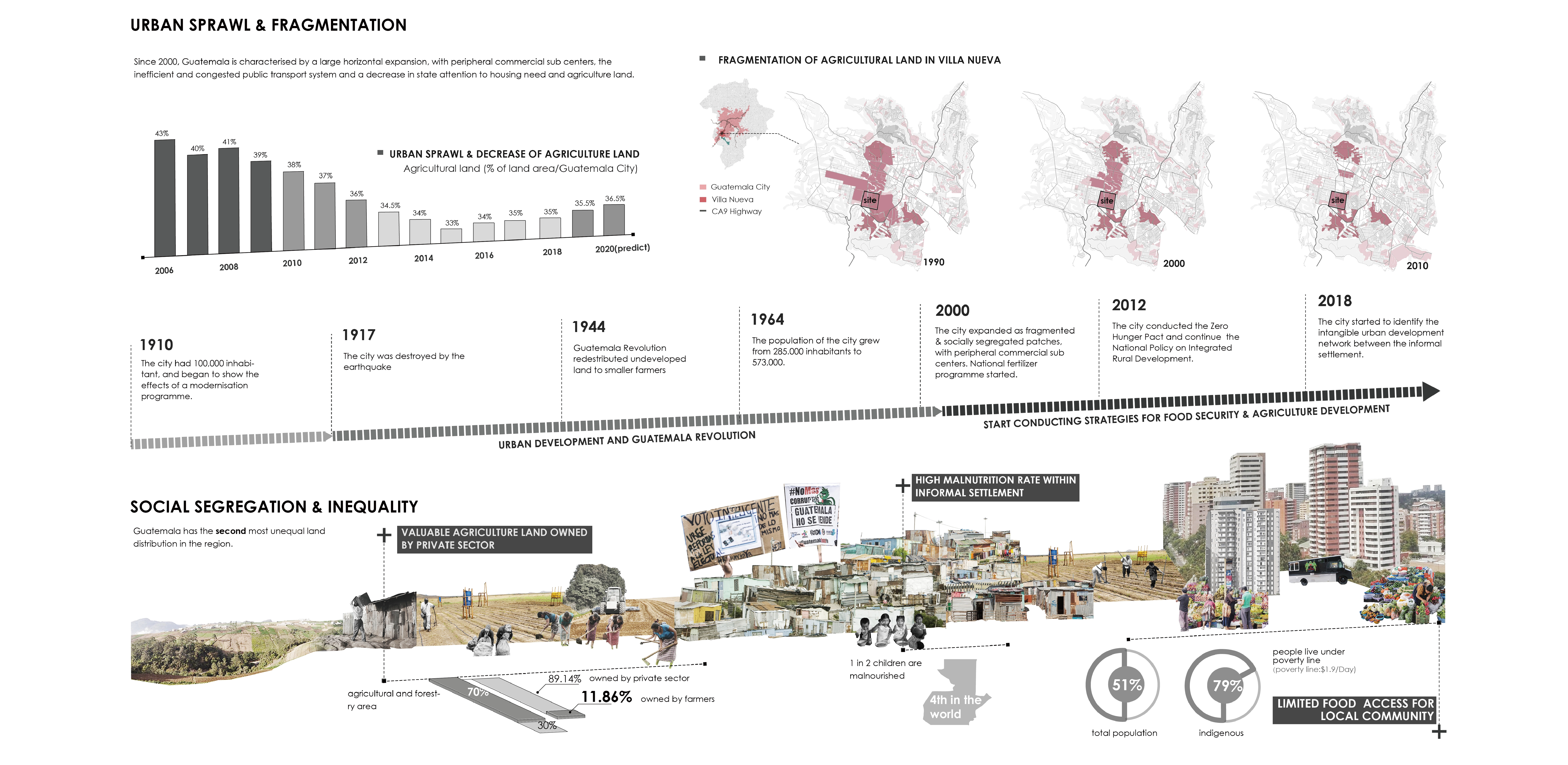
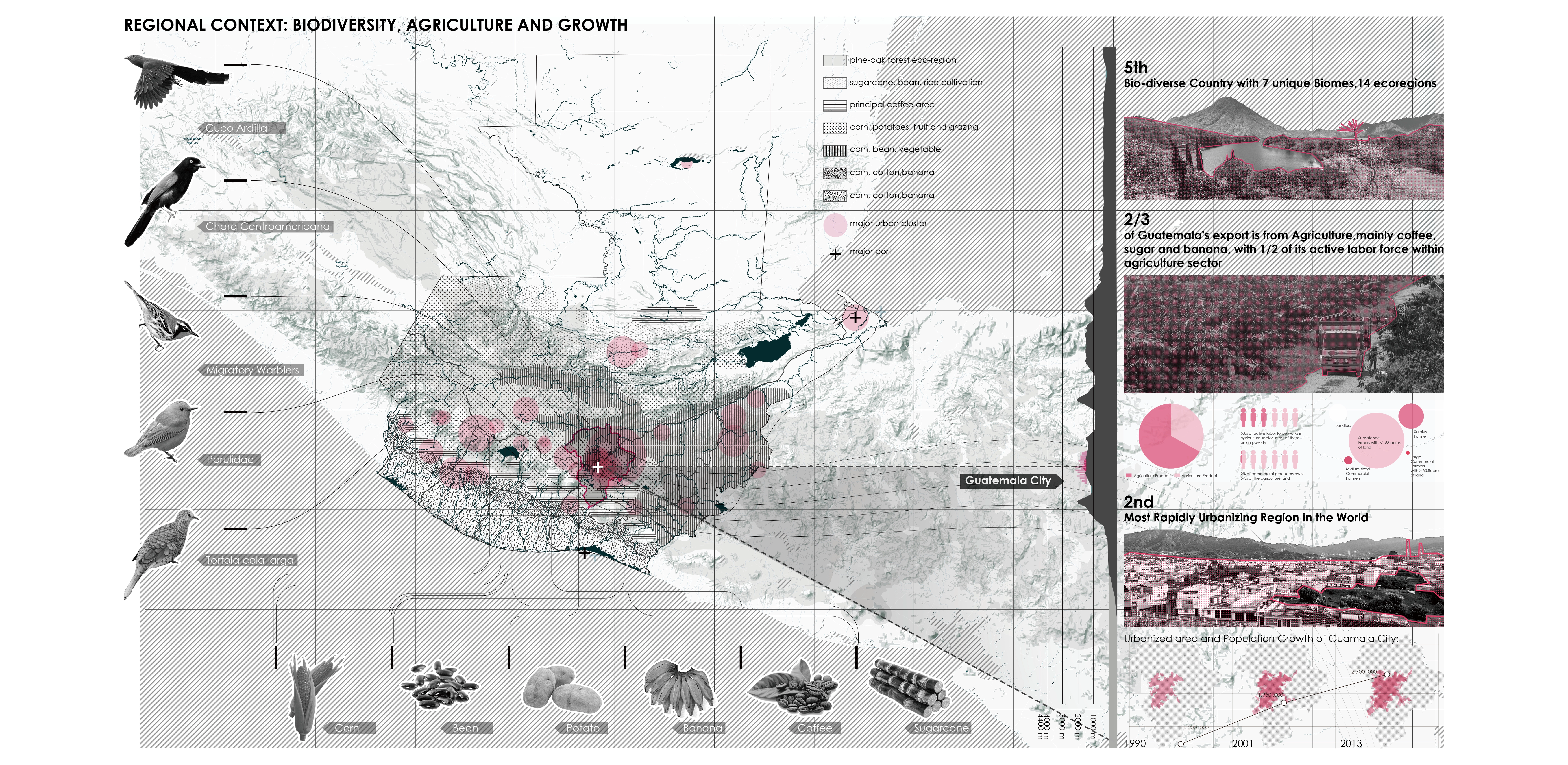
Located within the second most rapidly urbanizing region in the world, Guatemala City is characterized by urban sprawl, social fragmentation and exclusion. The topography, crisscrossed by deep gorges, increases the urban fragmentation. Fast urbanization also has been occurring, eroding the country’s rich ecologies and the long history of agricultural practices. Most of the low-income groups live in informal and sub-urbanized settlements, mostly located on high-risk sites at the urban periphery, with limited access to services and amenities.
The selected site - An Under-utilized Agricultural Void exemplifies how the aforementioned habitat/agricultural and urban conditions collide. Here the urban structure is highly fragmented, gradually occupying the remains of rich agricultural land, and as a patchwork of socially segregated neighborhoods.
We envision this urban void and the special opportunity to create an ecological and agricultural friendly district, stitching the spatially and socially segregated neighborhoods, reversing the dormitory city conditions and creating new opportunities for economic growth and urban amenities. -
The Broader Context and History
Guatemala has been facing a series of challenges brought by rapid and unequal growth, as the population from rural areas flock to urban areas seeking better opportunities, jobs, services and living conditions.
These peripheral areas also include middle-income areas, constructed as gated and car-dependent communities. The public transportation system is limited and constantly strained, while gridlock traffic is the norm (3-4 hours before, during, and after commercial hours), as commuters mobilize from the urban periphery to the main urban centers. The lack of public land and an ineffective Eminent Domain Law impedes urban design operations and the provision of infrastructure, social housing, communal services, and open spaces.
Considered as the fifth bio-diverse country in the world, Guatemala is comprised of 14 ecoregions which are the habitat for over 1,200 species. Agricultural practices date back to thousands of years carried out by the Mayans, in a sustainable manner. In the past 5 hundred years, first with the Spanish colonization and later after independence under the influence of the USA, large tracks of land have been exploited for commercial crops, frequently as monocultures, eliminating the local vegetation and habitats and resulting in disconnected patches of biomes. Agricultural exports (mainly coffee, sugar, bananas, and cotton) supports 25% of the country’s GDP.
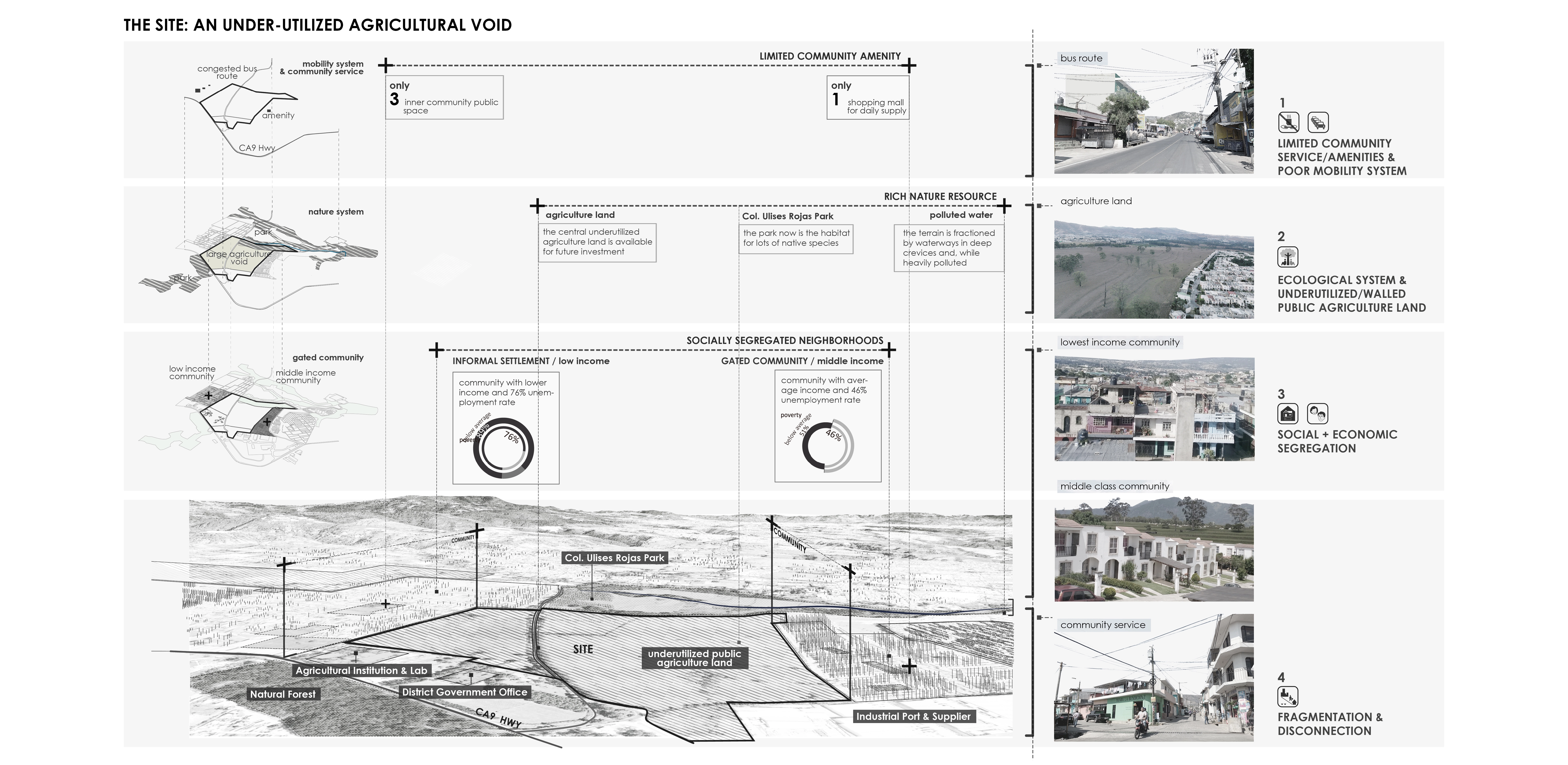
The Site: An Under-utilized Agricultural Void Currently Segregating Neighborhoods in the Peripheral Municipality of Villa Nueva
The large void at the center of the site has been kept free from urbanization since it is one of the few large tracks of public land in the city. It is under the custody of a respected agricultural school. However, this property is currently walled-off, and the land is underutilized.
Close to 50% of the terrain is idle, and the other half is subject to monocultural agricultural practices. To the north of the void, the terrain is fractioned by waterways in deep crevices and, while heavily polluted, they nourish densely vegetated areas. The agricultural property segregates low-income informal settlements located to the west of the void from middle-income gated communities to the west. The area lacks jobs, schools, medical facilities, sport, and recreational facilities. Accessibility is only provided by two-lane congested roads (which were the means of access to this previously rural precinct), thus accessibility is difficult, and public transportation is poor.
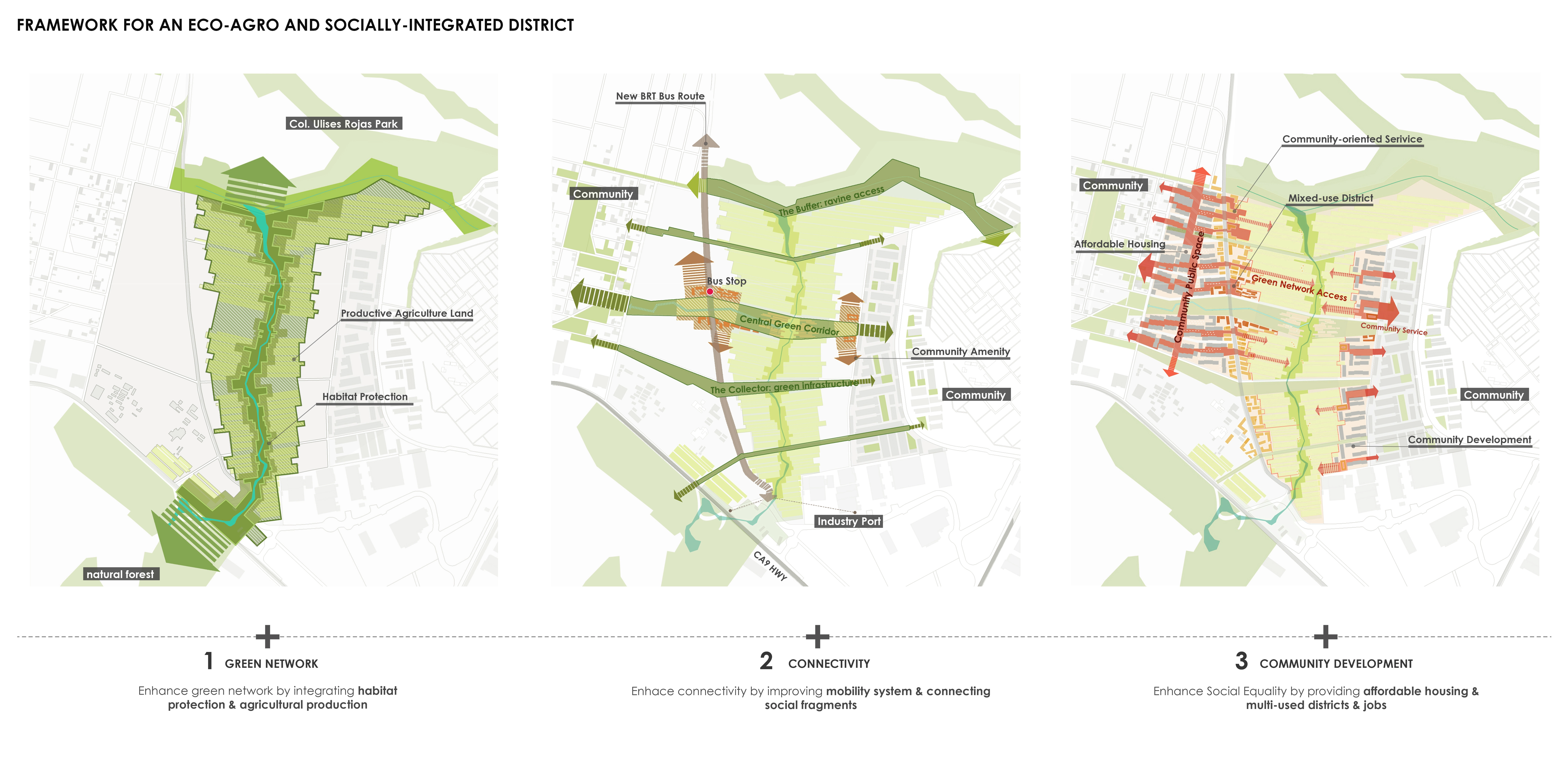
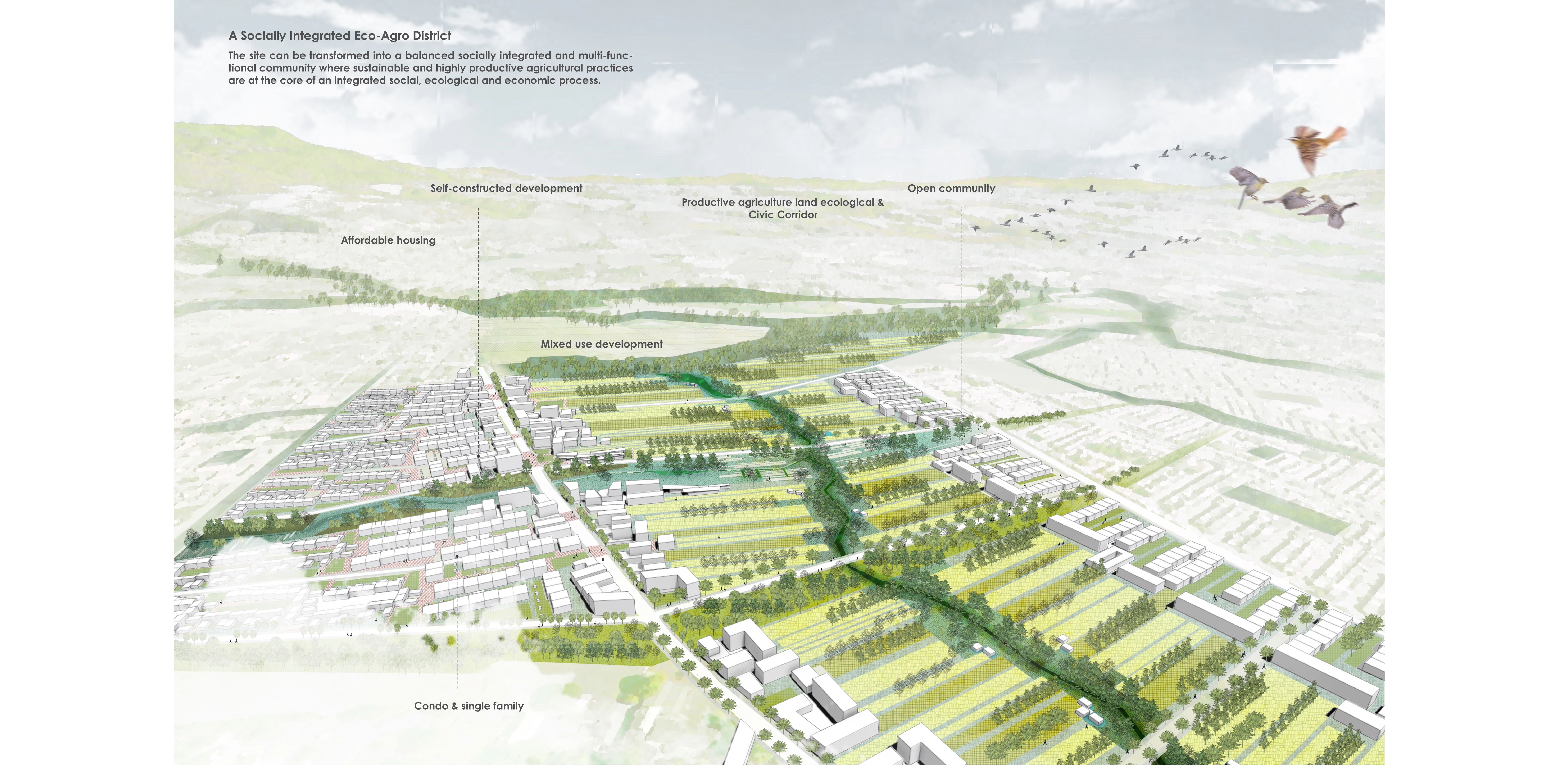
Goals and Strategies for a Socially-Integrated Eco-Agro District
Our goals focus:
1. Create an adaptive framework that allows space for balanced urban growth and responds to local ecology and urban agriculture (which water-management, agroforestry, and connecting and enhancing habitats);
2. Connect the communities to the country's agricultural legacy and cultural identity;
3. Favor social inclusion/interactions and equal access to infrastructure/services/amenities;
4. Provide a diversity of residential solution for different social groups;
5. Provide local jobs, diversity the economy and attract investment,
6. Envision multi-use transportation and pedestrian-friendly district
7. Take advantage of a special public institution and land, as a tool to implement the proposal (in a context in which this scale and nature of the operation are not common).
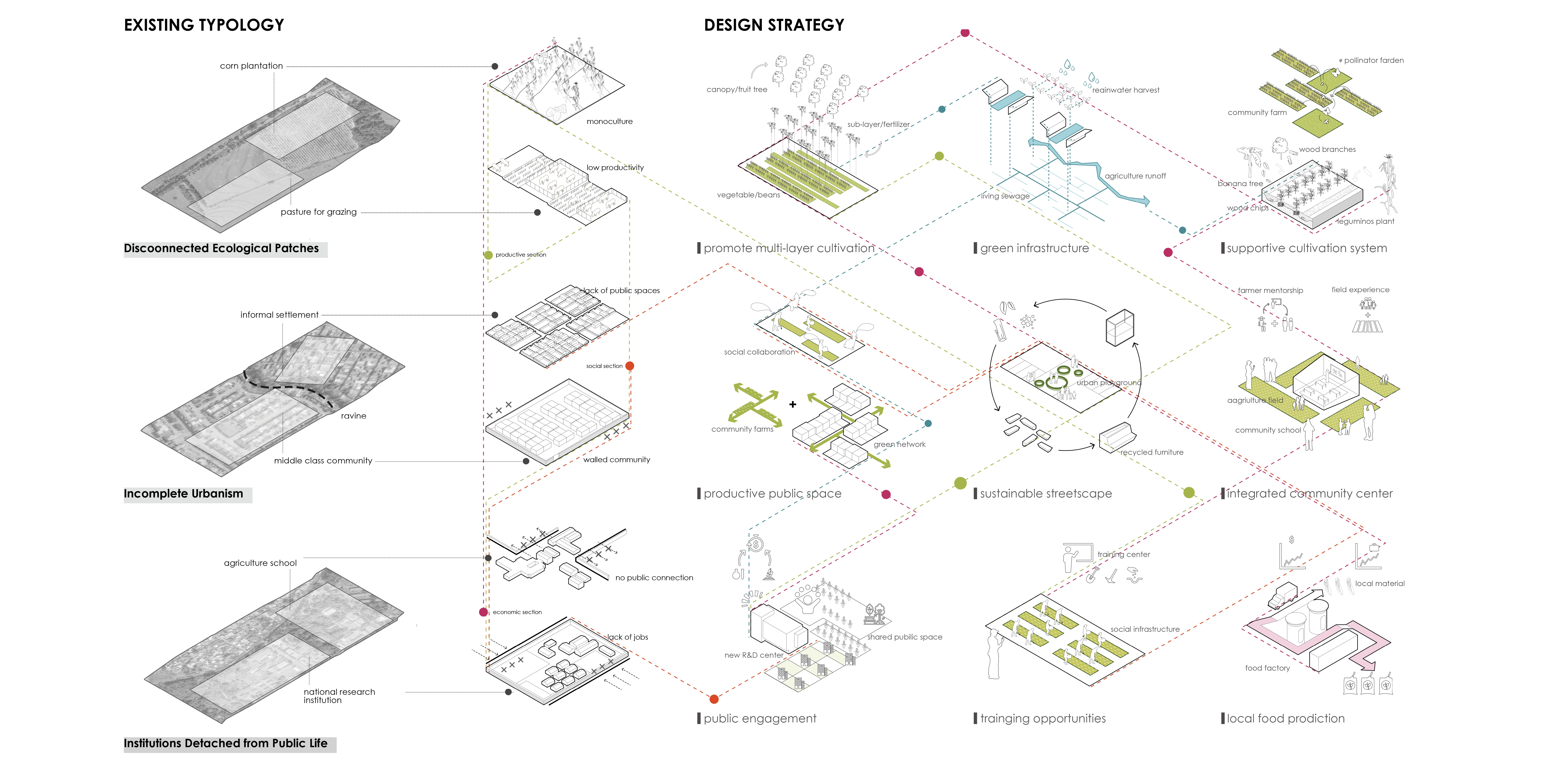
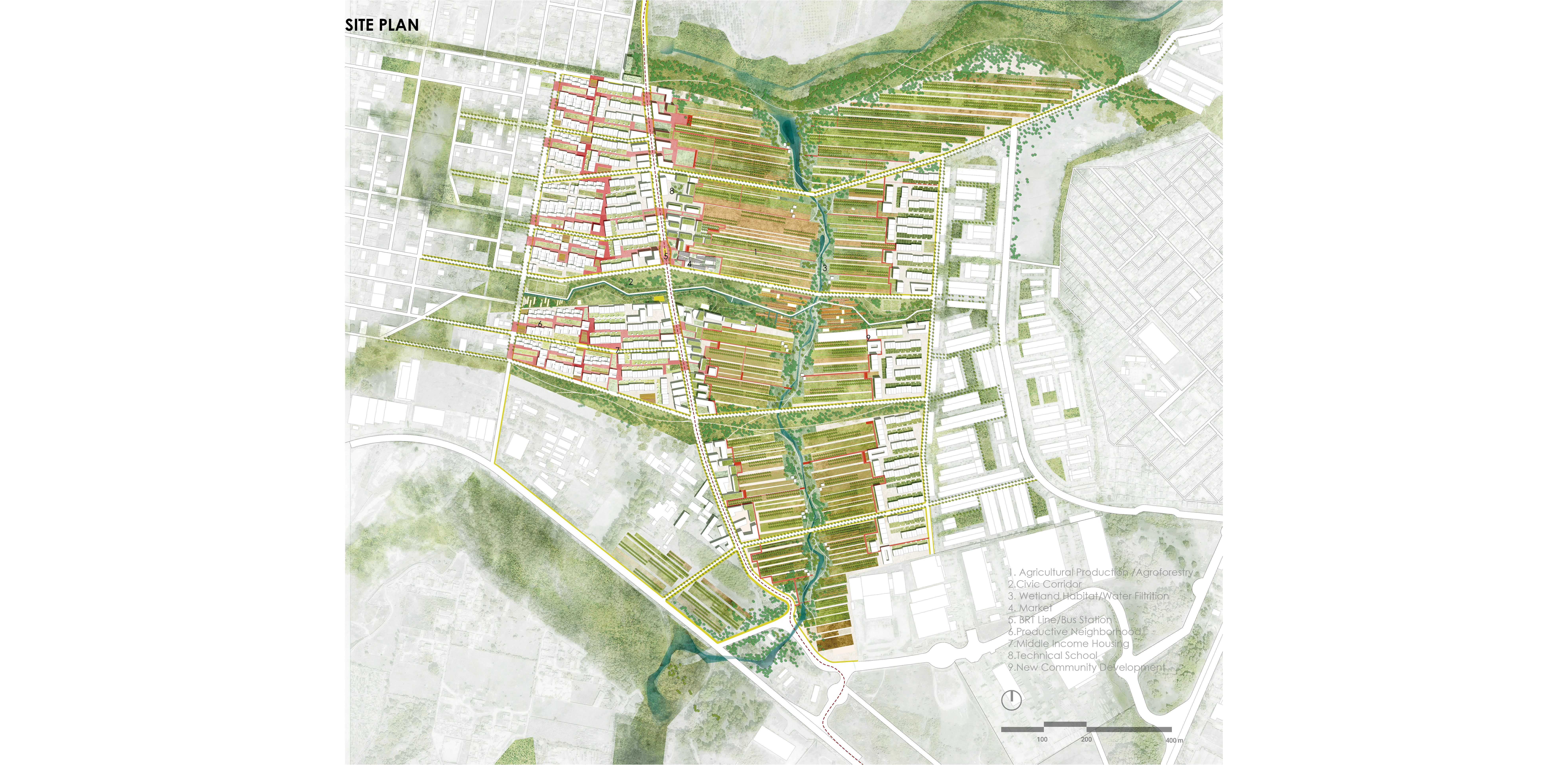
The main design components
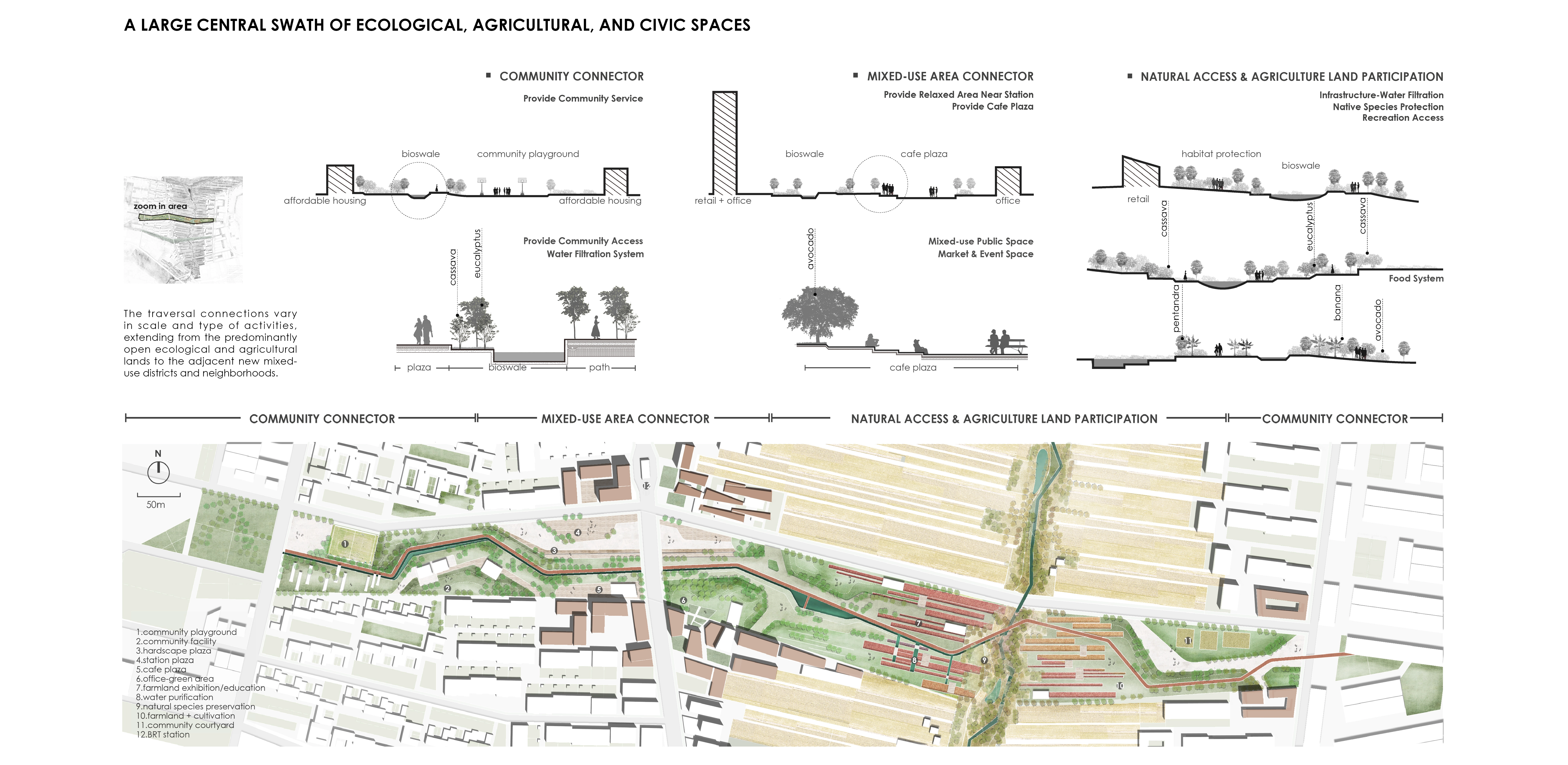
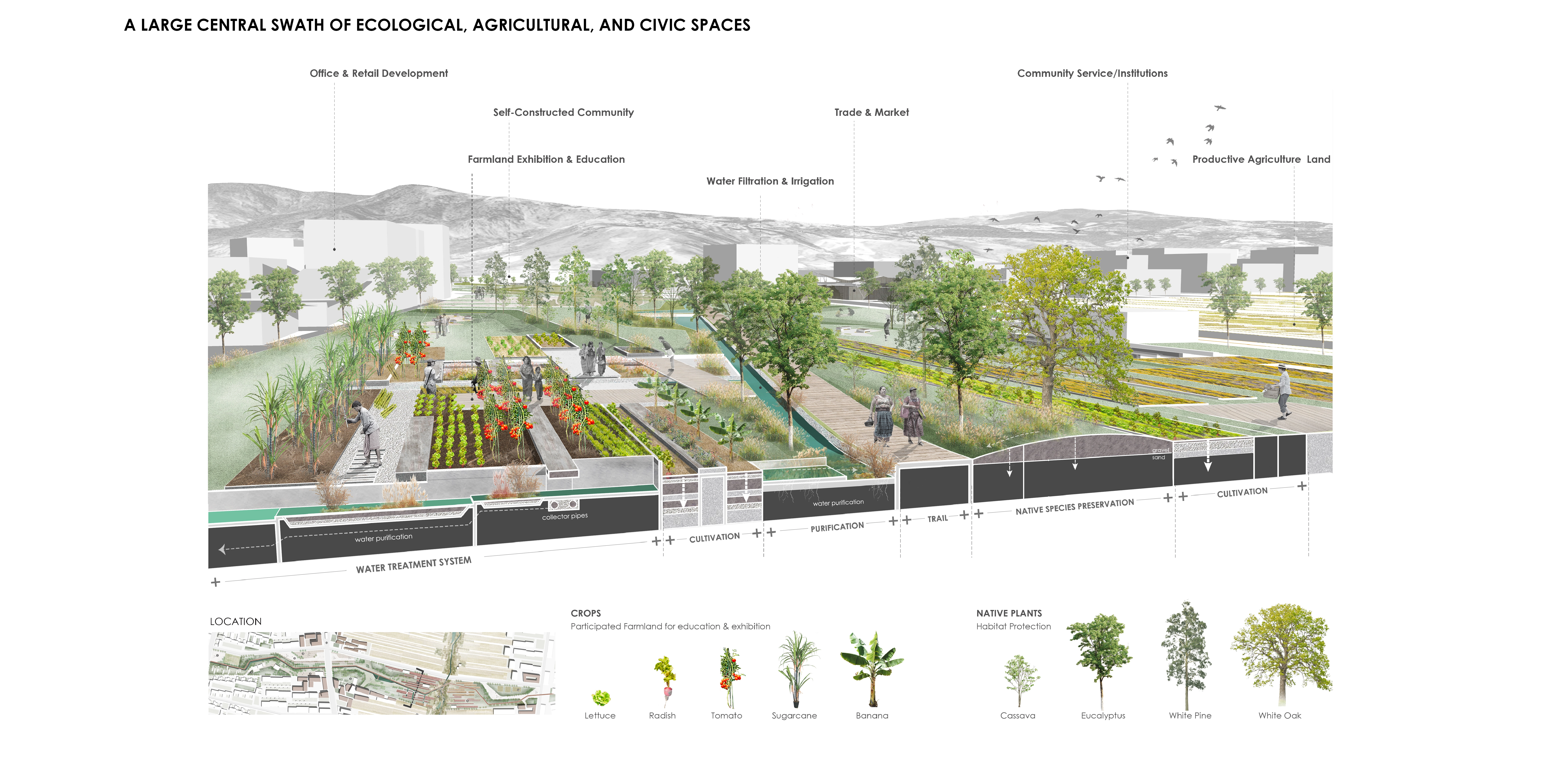
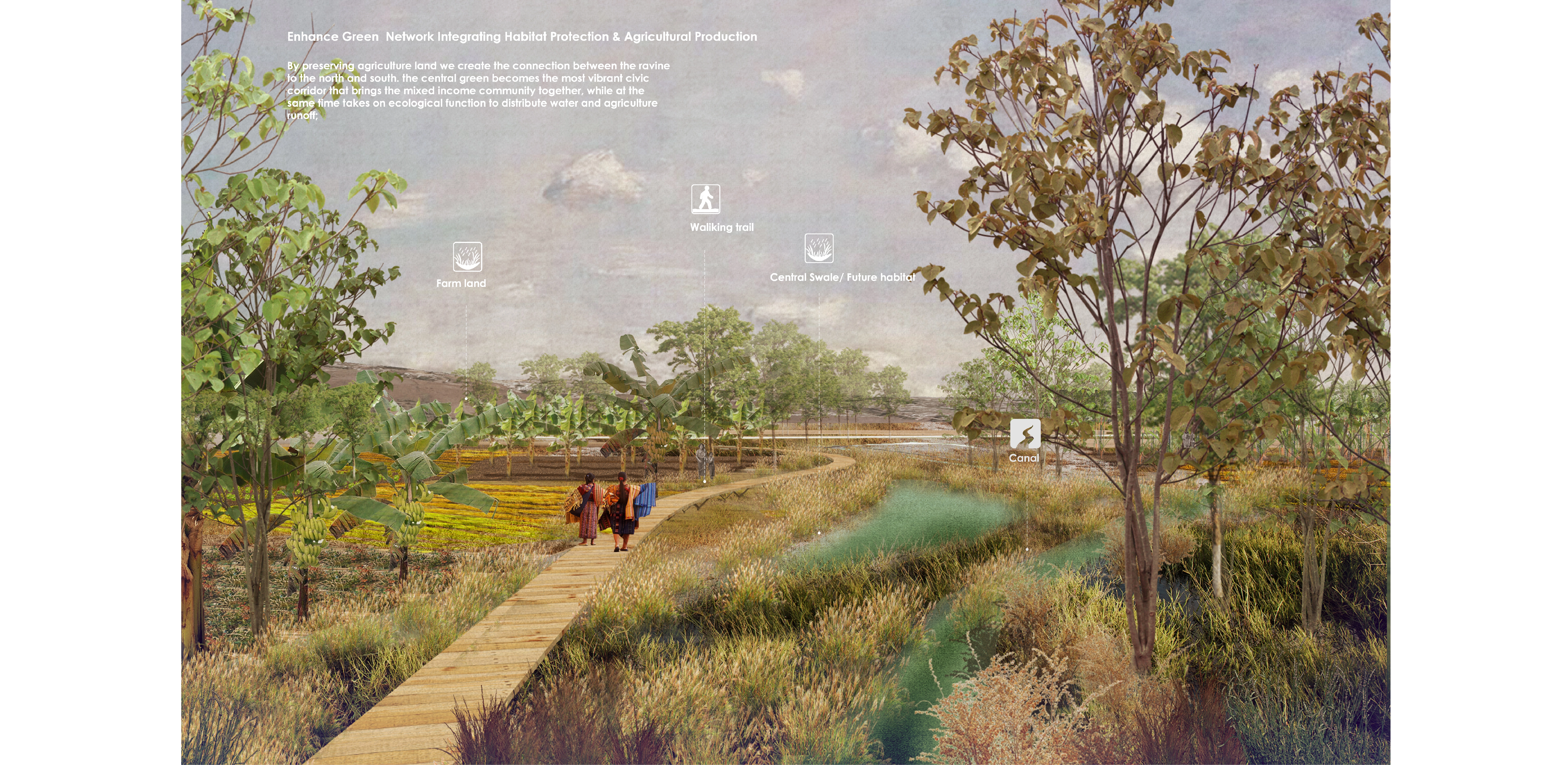
A Large central swath of ecological, agricultural, and civic spaces.
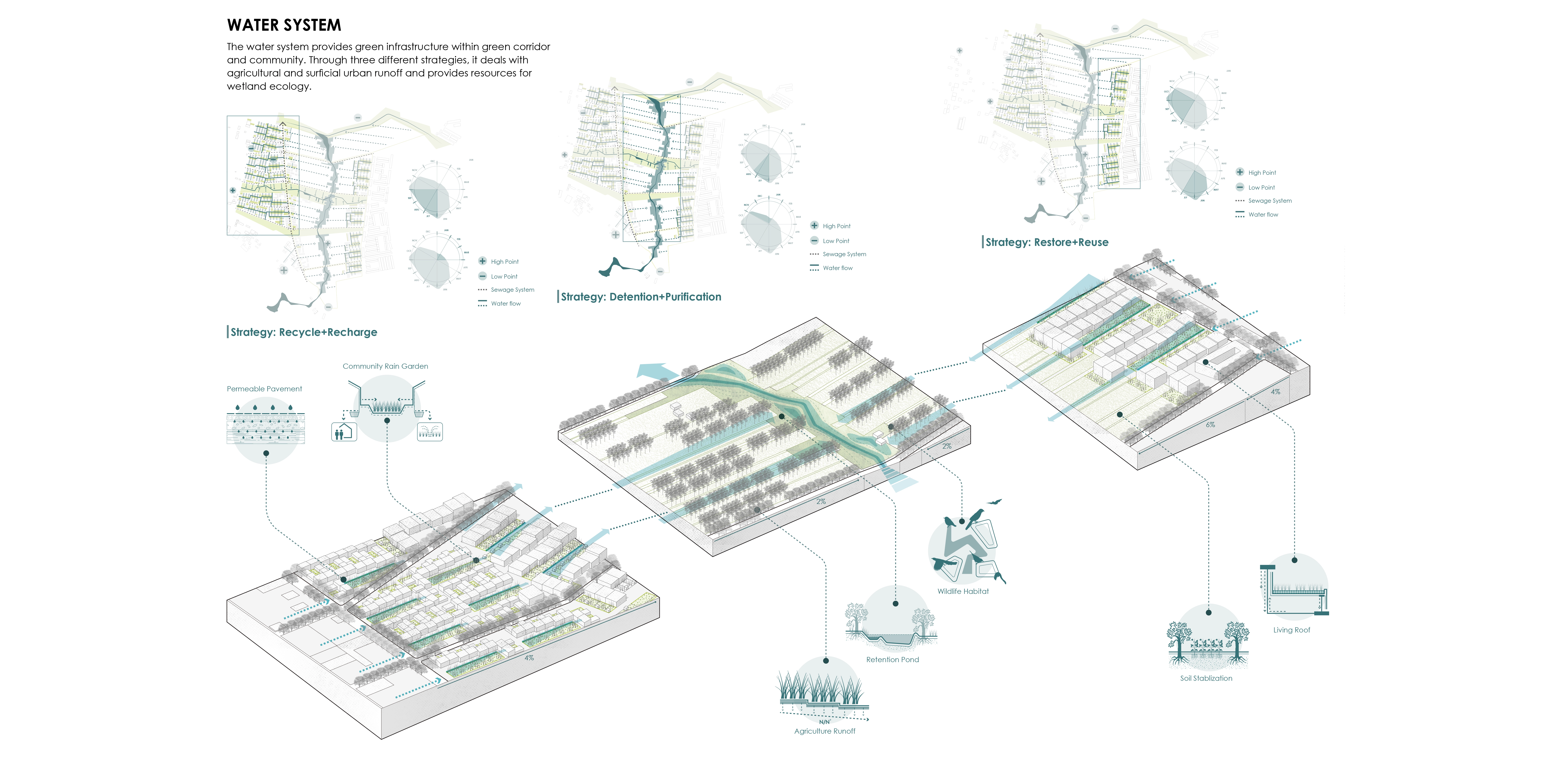
By preserving a large tract of open land it is possible to create a green infrastructure/water management eco-corridor, connecting the ravines and vegetated at the north to other vegetated patches to the south, and well as to establish multiple links (pedestrian and bike paths, civic activity corridors, and roads) between the low-income communities to the west and the middle and the middle-income neighborhoods to the east.
The green infrastructure also allows for managing agricultural and surficial urban runoff and provides for wetland ecologies. The large open tracks of land, assisted by the agricultural institutions, can combine agroforestry, more productive, and specialized agriculture plots, providing produce to markets, businesses, and communities (who also participate in the farming). They also include communal services and amenities, public spaces, serving as an ample ecological and productive agricultural park.
The traversal connections vary in scale and type of activities, extending from the predominantly open ecological and agricultural lands to the adjacent new mixed-use districts to the existing neighborhoods. It is important to mention that such spatial, functional, and social integration is achieved thanks to the presence of the public land and that in conventional real-estate driven urbanism plans usually enacted in the country, the agricultural land would be lost, and the different social groups would not interact.
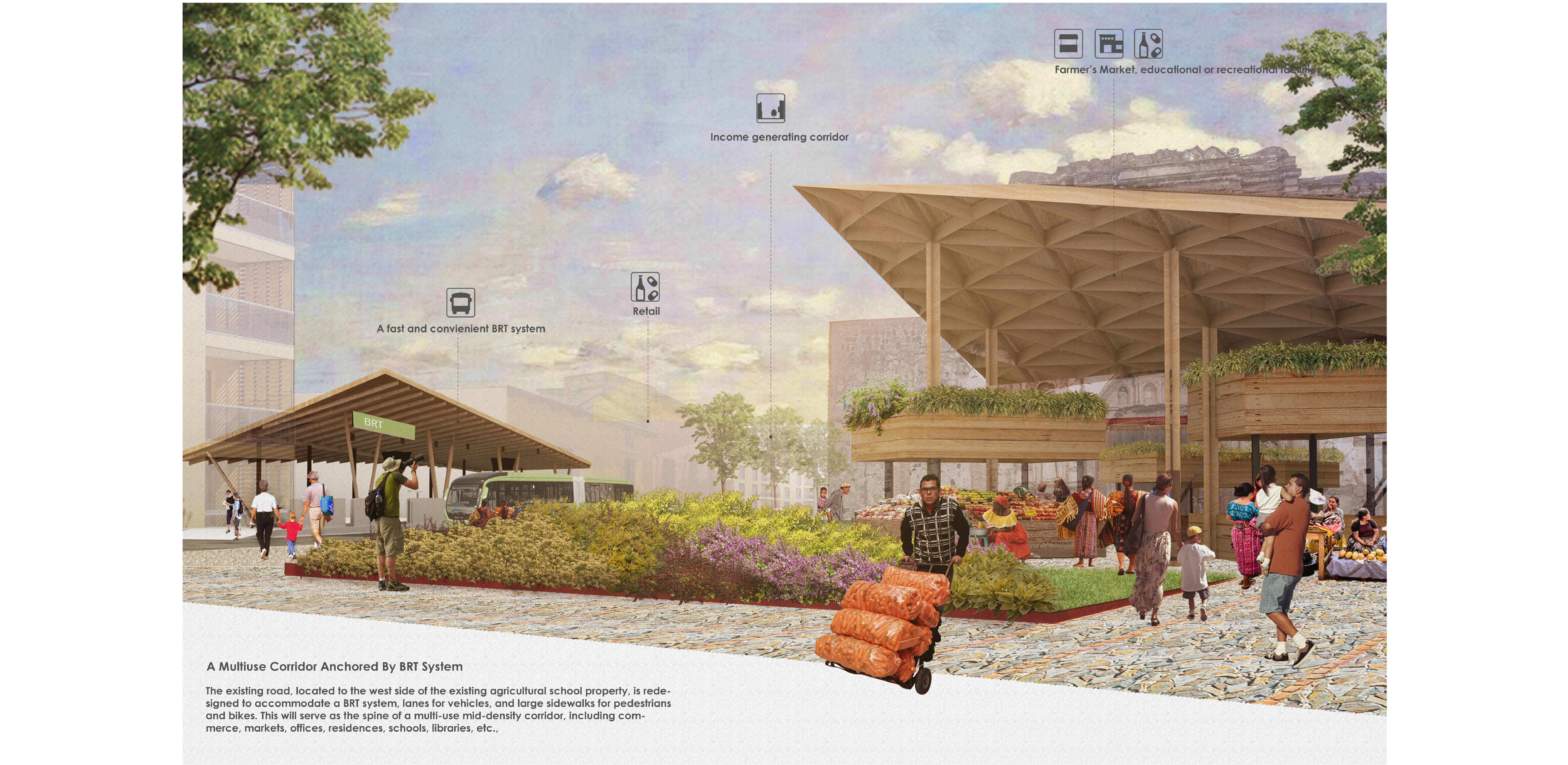
A multiuse mid-density corridor anchored on a BRT system.
The existing road, located to the west side of the existing agricultural school property, is redesigned to accommodate a BRT system, lanes for vehicles, and large sidewalks for pedestrians and bikes. This will serve as the spine of a multi-use mid-density corridor, including commerce, markets, offices, residences, schools, libraries, etc., which will attract investments, providing jobs, services, and amenities, and in turn, provide for funding to support actions in the public real and social housing. The stations of the BRT system coincide with the main civic transversal corridors and are close to important communal services as the markets, educational or recreational facilities. Here again, the transformation of the two-lane road into this mobility, service, multi-use, and an income-generating corridor is also possible thanks to tapping on a fringe of the public land.
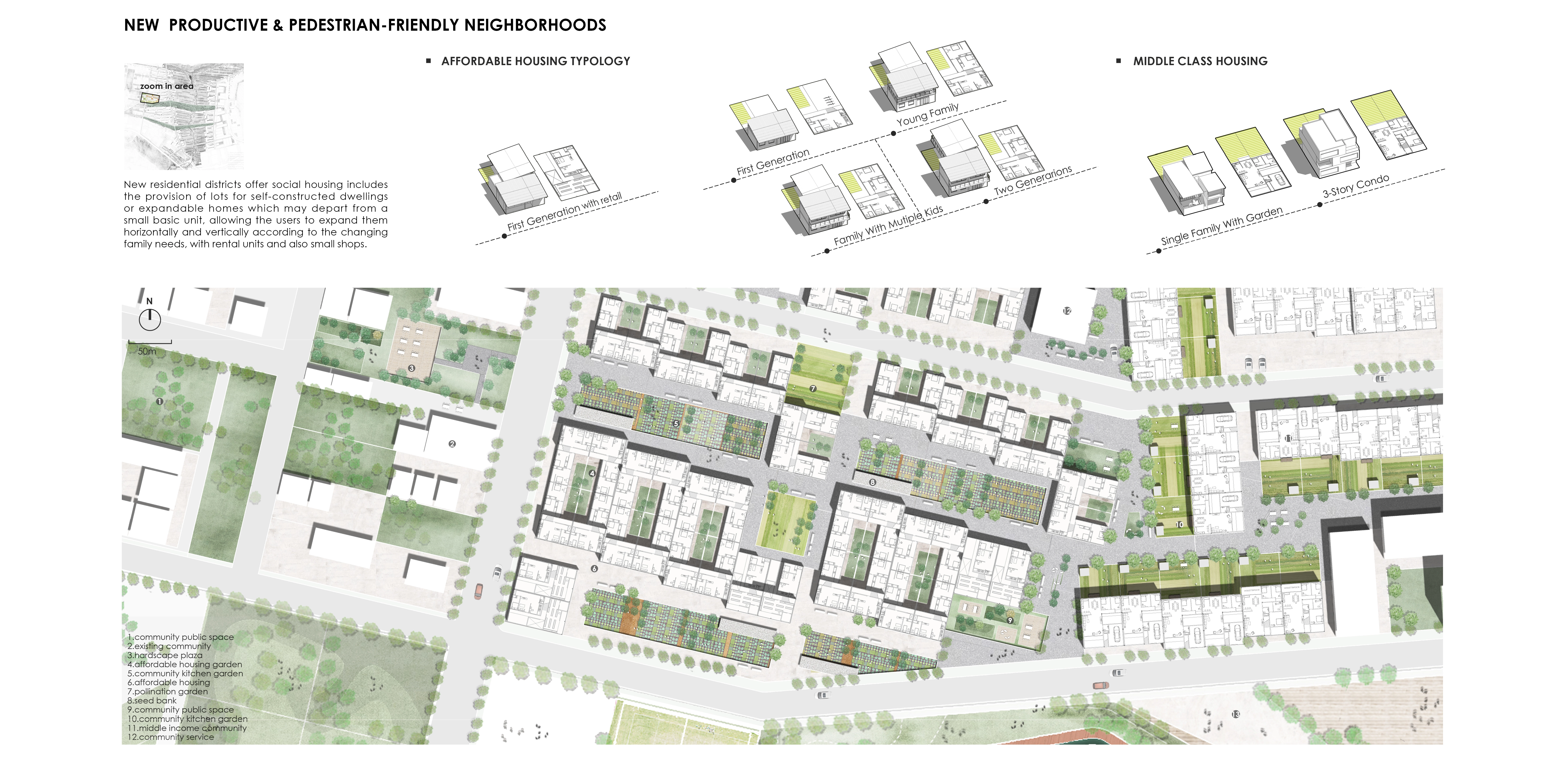
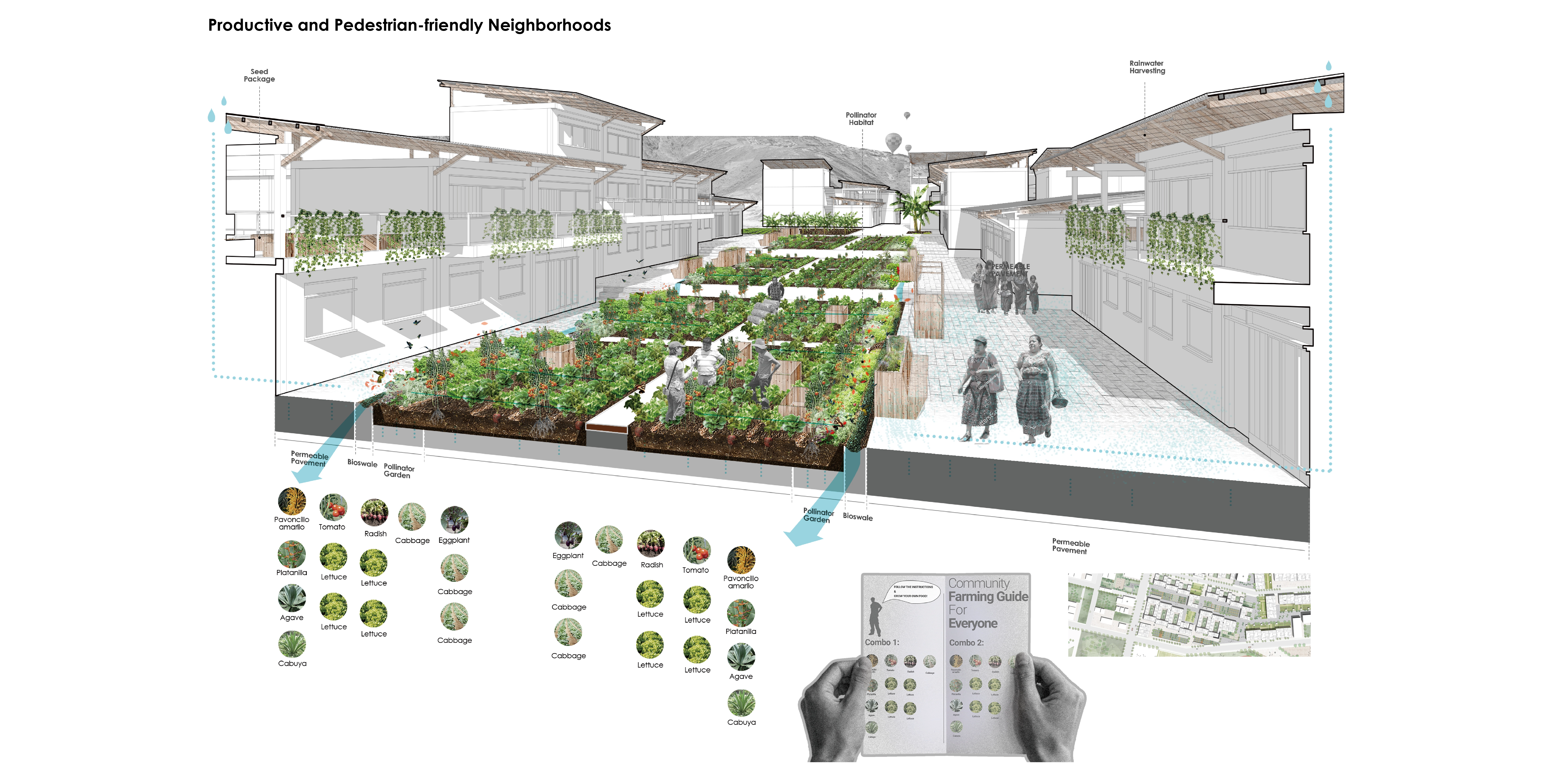
Productive and pedestrian-friendly new neighborhoods for different income groups. To the west of then mixed-use corridor, new residential districts offer social housing, particularly for low-income groups. These include the provision of lots for self-constructed dwellings or expandable homes which may depart from a small basic unit, allowing the users to expand them horizontally and vertically according to the changing family needs, accommodating rental units and also small shops. Some areas closer to the mix-used corridor are subsidized low rise formal housing, attracting young professionals, and favoring the social mix.
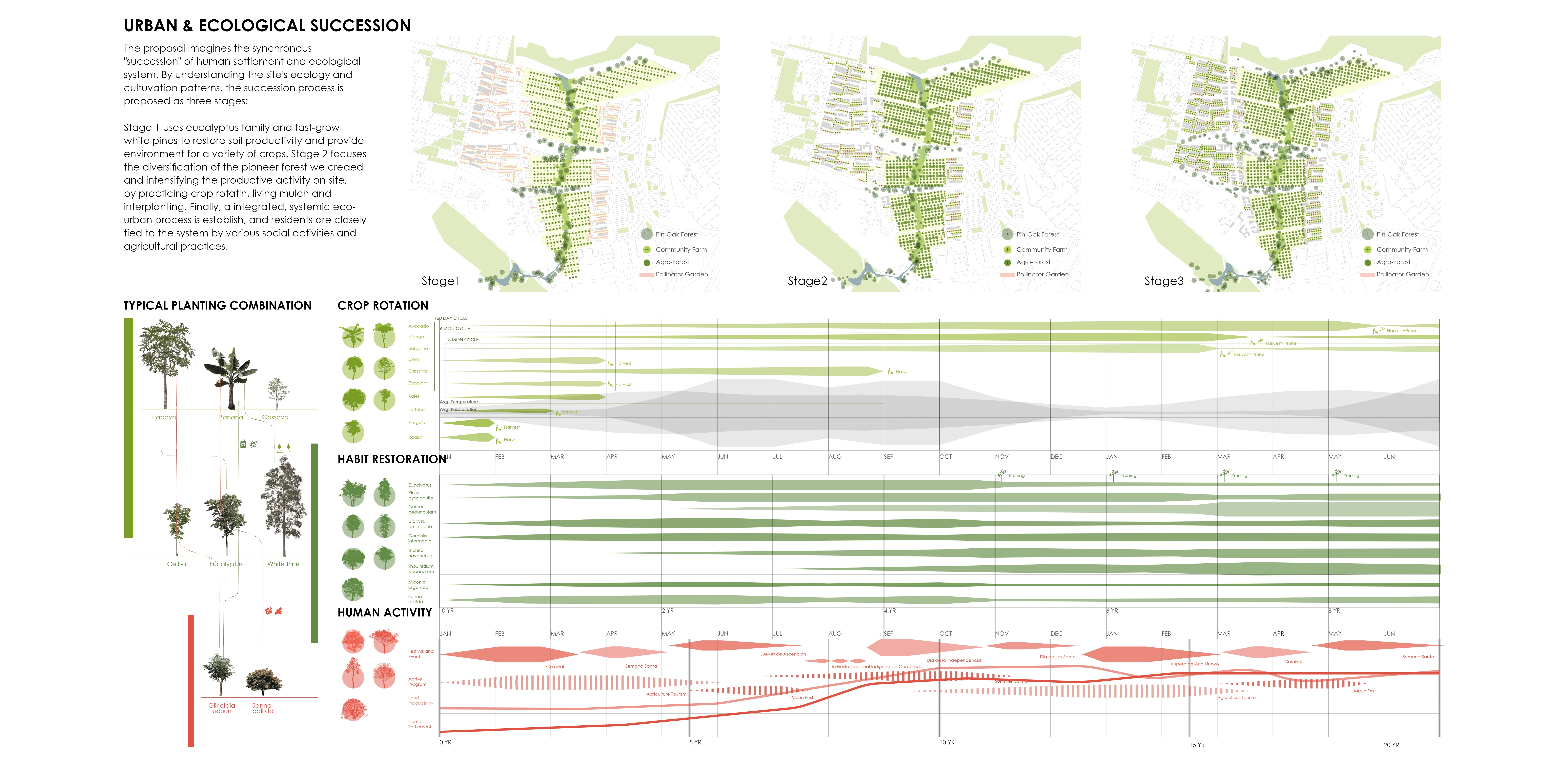
The residential areas are organized around agricultural cooperative clusters, taking into account agricultural succession, allowing to produce food for the residents as well as supplements to serve markets and residents as additional sources of income, while fostering community engagement. Some units have backyard patios with family gardens. Seed packages and a community agriculture guide is provided for new settlers, promoting crop rotation, drip irrigation as well as rainwater harvesting to enhance a resilient community. Pollinator gardens are created along the street as well as the public space, using indigenous species to help secure larger-scale agriculture production. The agricultural practice and process thus become a closely connected component of the social life of the community.
Vehicular roads are minimized and a network of pedestrian paths and communal meeting areas connect these new residential areas with the existing informal settlements, to the main activity corridor, and extend to the large eco-agro park. Similarly, to the east of the central green swath new predominantly residential middle-income neighborhoods create an amicable and porous edge, and when possible connect to the existing gated communities further east. Schools, commercial facilities, and other amenities anchor these residential areas to the traversal civic corridors.
Conclusion and Long-Term Vision
This currently under-utilized and homogeneous agricultural site, which separates informal from formal neighborhoods, can transform the area into a balanced socially integrated and multi-functional community where sustainable and highly productive agricultural practices are at the core of an integrated social, ecological and economic process.
The strategy coupled with the ecological succession proposal can be further applied to other communities in Guatemala. The municipality of Villa Nueva can collaborate with local educational institutions, World Food Programme and communities to retrofit the unique agricultural landscape while addressing ecological aspects, also serve as the morphological and performative framework for the urban design of the district. -
- Senna pallida
- Miconia argentea
- Diphysa americana
- Garcinia intermedia
- Thouinidium decandrum
- Pinus ayacahauite
- Gliricidia sepium
- Ceiba pentandra
- Quercus corrugata
Advertisement
Related Awards
Honor Award, Urban Design
Urban Balcony Embracing Rewilded Nature
In a densely populated urban setting, this project unveils a rewilded natural area, revitalizing a former concrete waterway through innovative stormwater management. The design introduces a linear activity zone extending over four residential blocks, tailored for diverse social interactions. It underscores the vital role of landscape architecture in enriching the social and ecological aspects of urban living.