.webp?language=en-US)


Lumberton Community Floodprint: Strategies for Repurposing Vulnerable Landscapes After Disaster
In Lumberton, a city whose past and present identity is shaped by the water flowing through it, planning for floodwaters is a crucial way for its residents to embrace their environment and find opportunity instead of risk. Within the city, the plan attempts to provide more equitable access to open parks while reducing risk to the most vulnerable parts of its population. A proposal of buyouts for at-risk homes and a strategic organization of vacant lands within the floodplain would provide a network of greenways extending across more than 800 acres, moving residents out of harm’s way and fostering a sense of appreciation for water instead of foreboding.
Awards Jury
-
The Lumberton Community Floodprint addresses the devastation Hurricanes Matthew and Florence caused to the City of Lumberton, NC. The project introduces the concept of a “floodprint” — an innovative landscape planning approach guided by water-land relationships, including the powerful forces of flooding, recovery and equity. The hyper-local Floodprint process uses landscape analyses and planning strategies to address: hazard mitigation and disaster recovery; social vulnerability; land and water conservation; policy, administration and finance; and natural resource management practices.
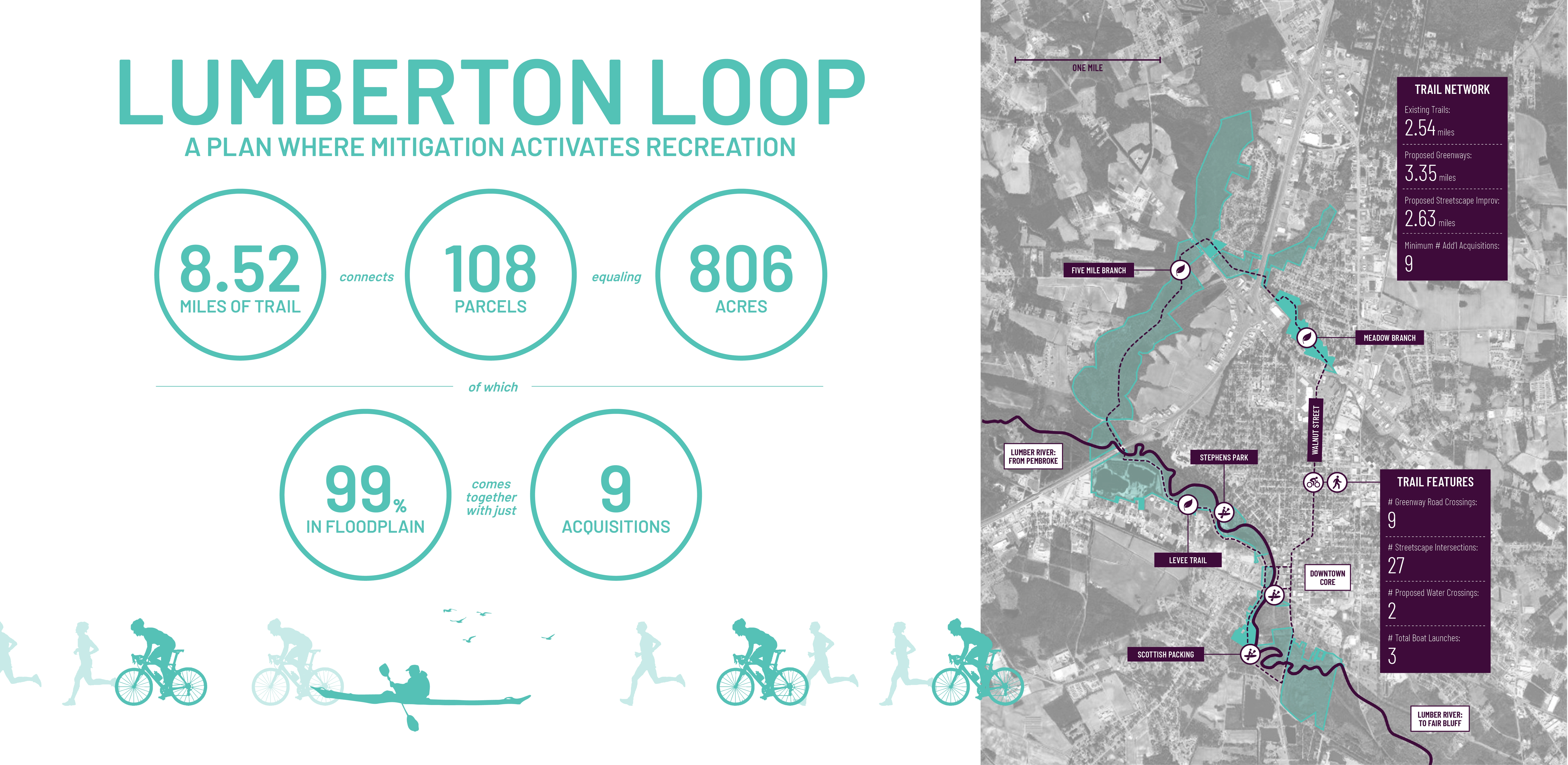
Project outcomes create opportunities for Lumberton to transform its vacant parcels into places for water storage, habitat and recreation. The plan connects 806 acres and provides 8.5 miles of trails into a unified, community-wide greenway, of which 99% resides within the 100-year floodplain. Associated sub-area plans propose short-, mid- and long-range improvement projects and management strategies. The processes and outcomes enabled through the Floodprint process continue to increase social and physical resilience in the city, specifically through actionable and scalable land-use strategies that reduce risk while simultaneously improving public safety and long-term environmental function within historically flood-prone neighborhoods. -
Background:
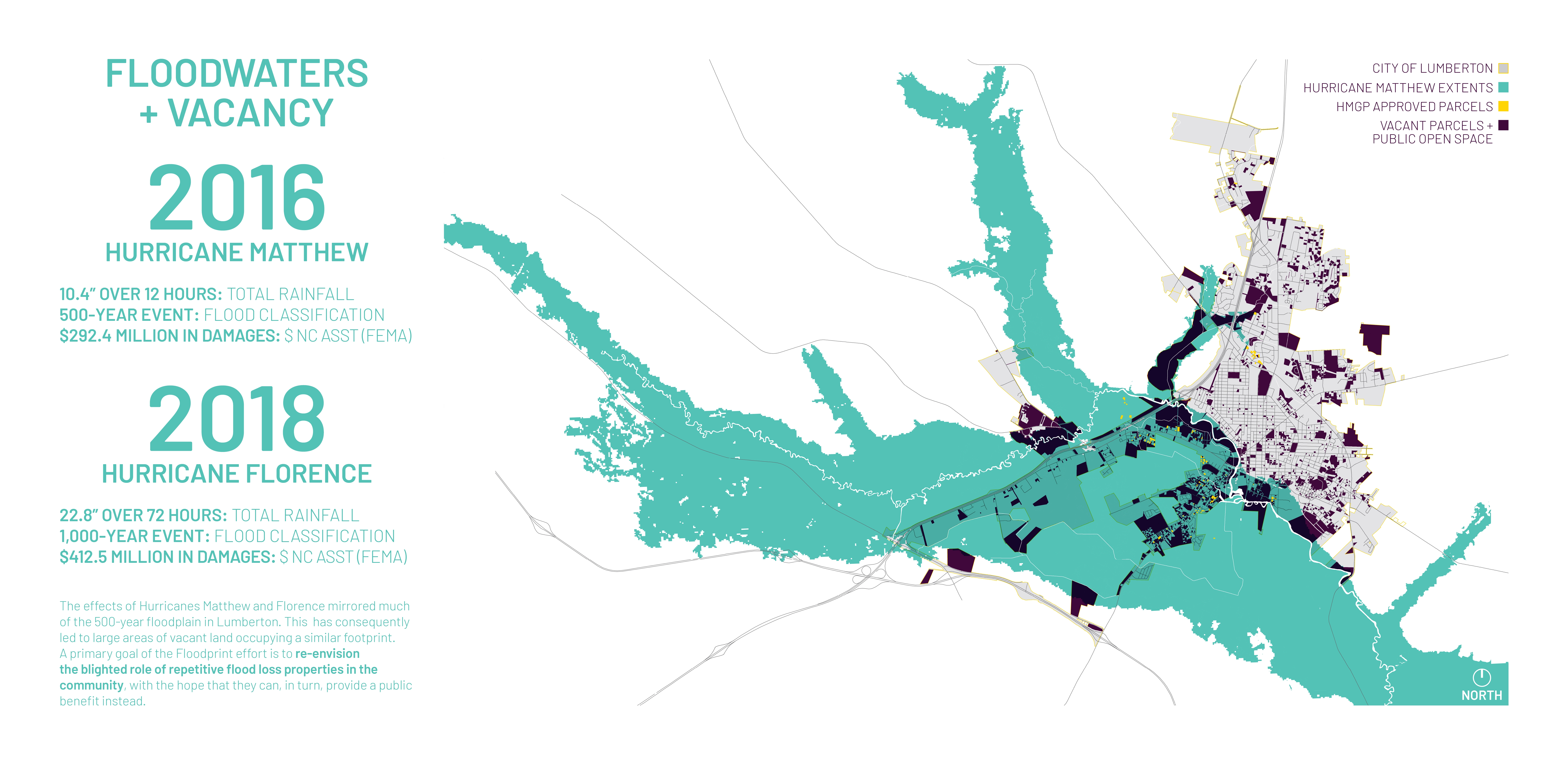
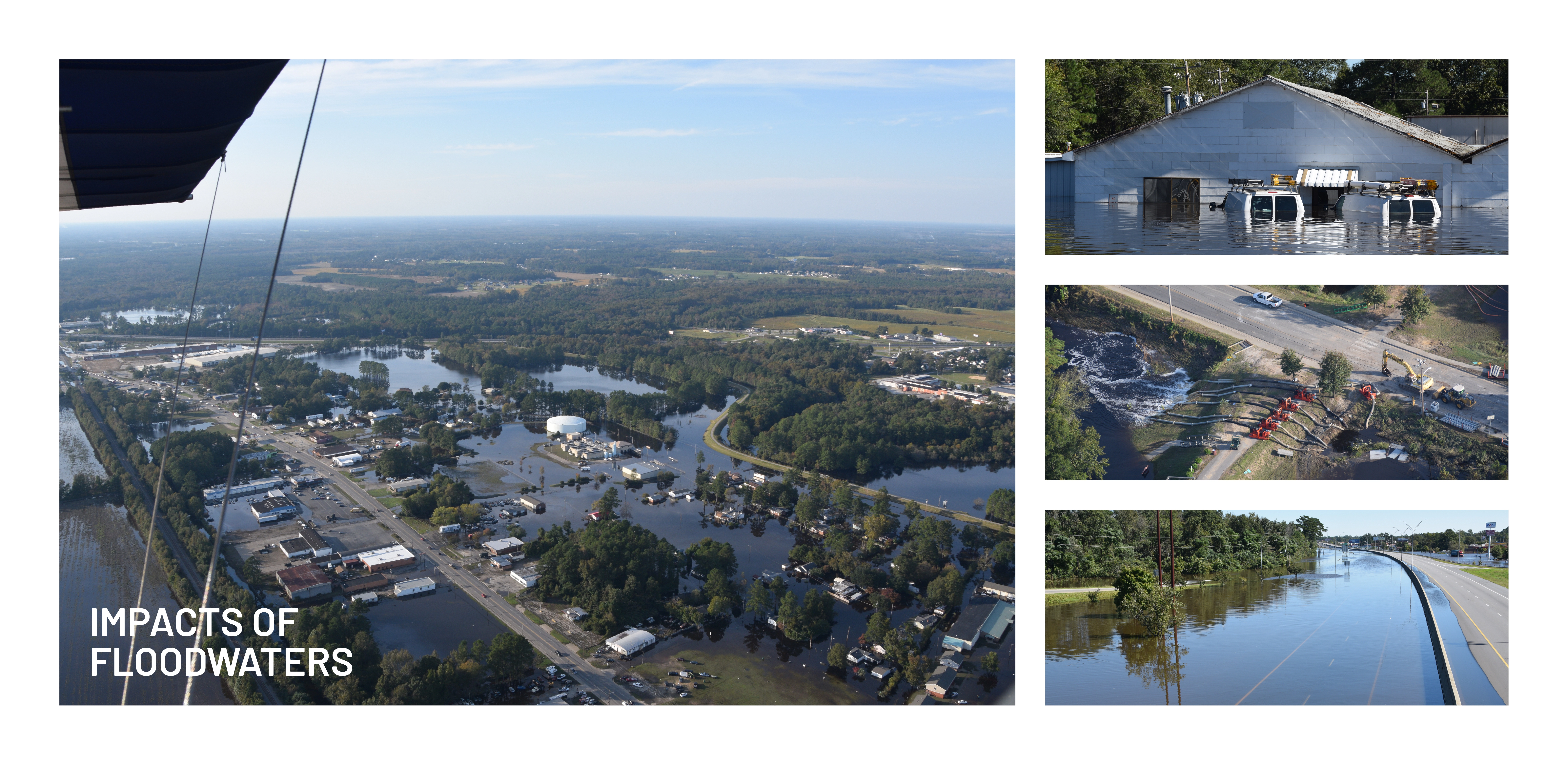
In North Carolina alone, Hurricane Matthew (2016) caused $4.8 billion in damage and displaced thousands of families due to flood waters. Hurricane Florence (2018), making landfall less 23 months later, is estimated to have caused an additional $17 billion in monetary damages to the state. Tragically, Hurricane Florence hit the City of Lumberton, North Carolina (population 21,040) before implementation of Hurricane Matthew community recovery planning efforts were completed, with flood waters from both storms devastating many of the same areas.
Lumberton Community Floodprint:
The Lumber River is the lifeblood of the communities that occupy its edges, including the City of Lumberton. The city, established in 1787, owes its location and existence to the abundant resources provided by the river, tributaries and floodplains. These natural features have made deep and lasting physical and cultural impressions that continue to influence both city and region. Recognizing that river and city are inseparable, this planning study introduces the concept of a “floodprint” — an innovative landscape approach to community analysis and planning that is guided by land-water relationships, including the powerful forces associated with flooding, recovery and equity.
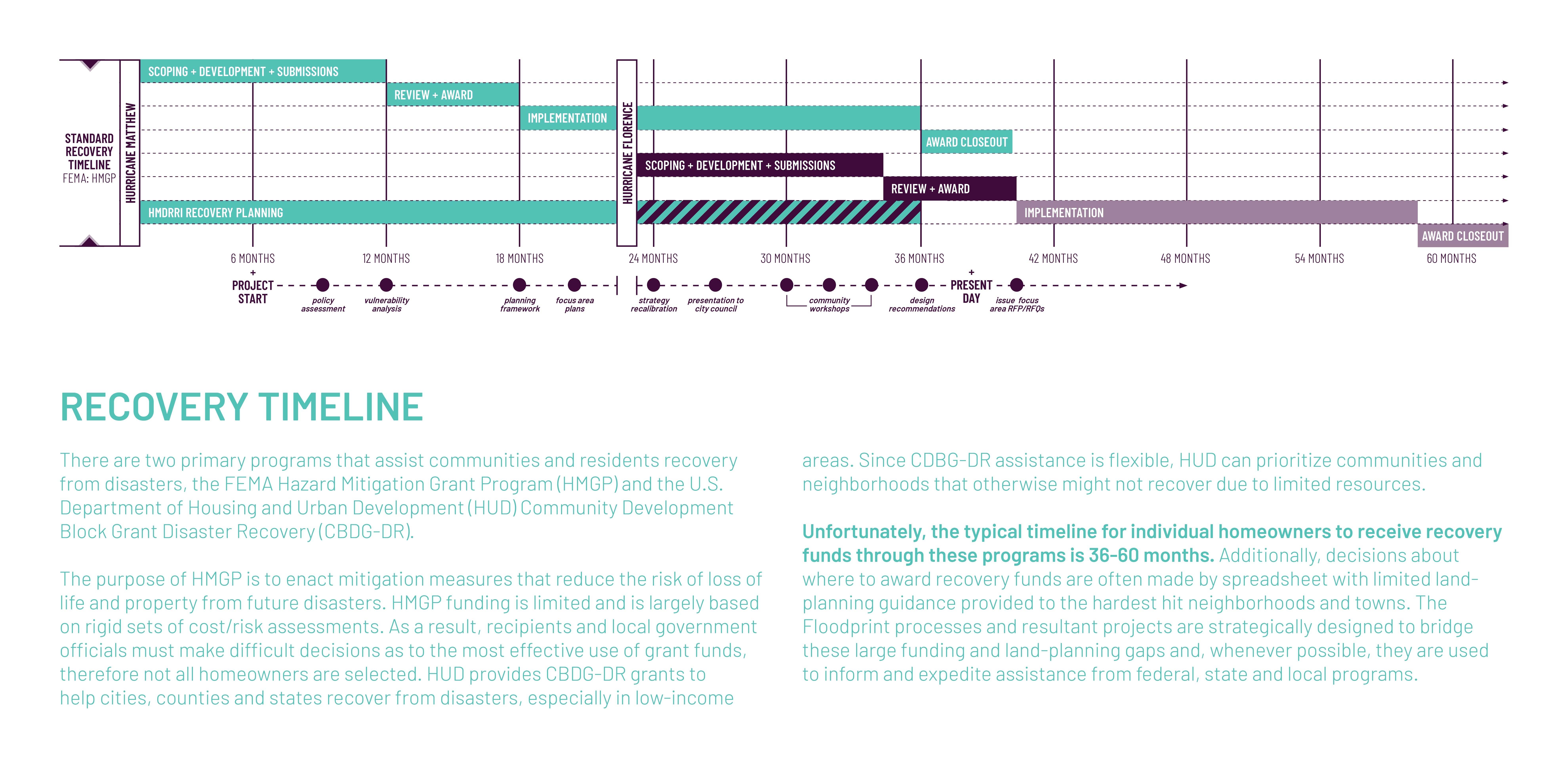
The Lumberton Community Floodprint is the result of interdisciplinary work reflecting the best practices in rural resilience, as defined and organized around: community design and planning; post-disaster recovery procedures and financing; public policy and administration; and landscape planning and design. Begun in 2017 following Hurricane Mathew and continuing to present day, the goal of the community Floodprint process is to assist the City of Lumberton increase social and physical resilience within flood-prone areas. The project team used robust analytical methods, including but not limited to: geospatial analytics, hydrologic and hydraulic modeling, neighborhood meetings, federal policy and recovery funding program assessments, comparative park financing metrics, regional recreation gap analysis, and alternative futures illustrations. Together these analyses informed the development of a community plan that respects and reflects local character and history to guide community leaders in making local land-use decisions that reduce risk, improve public safety, and enhance long-term social and ecological functions within historically flood-prone areas.
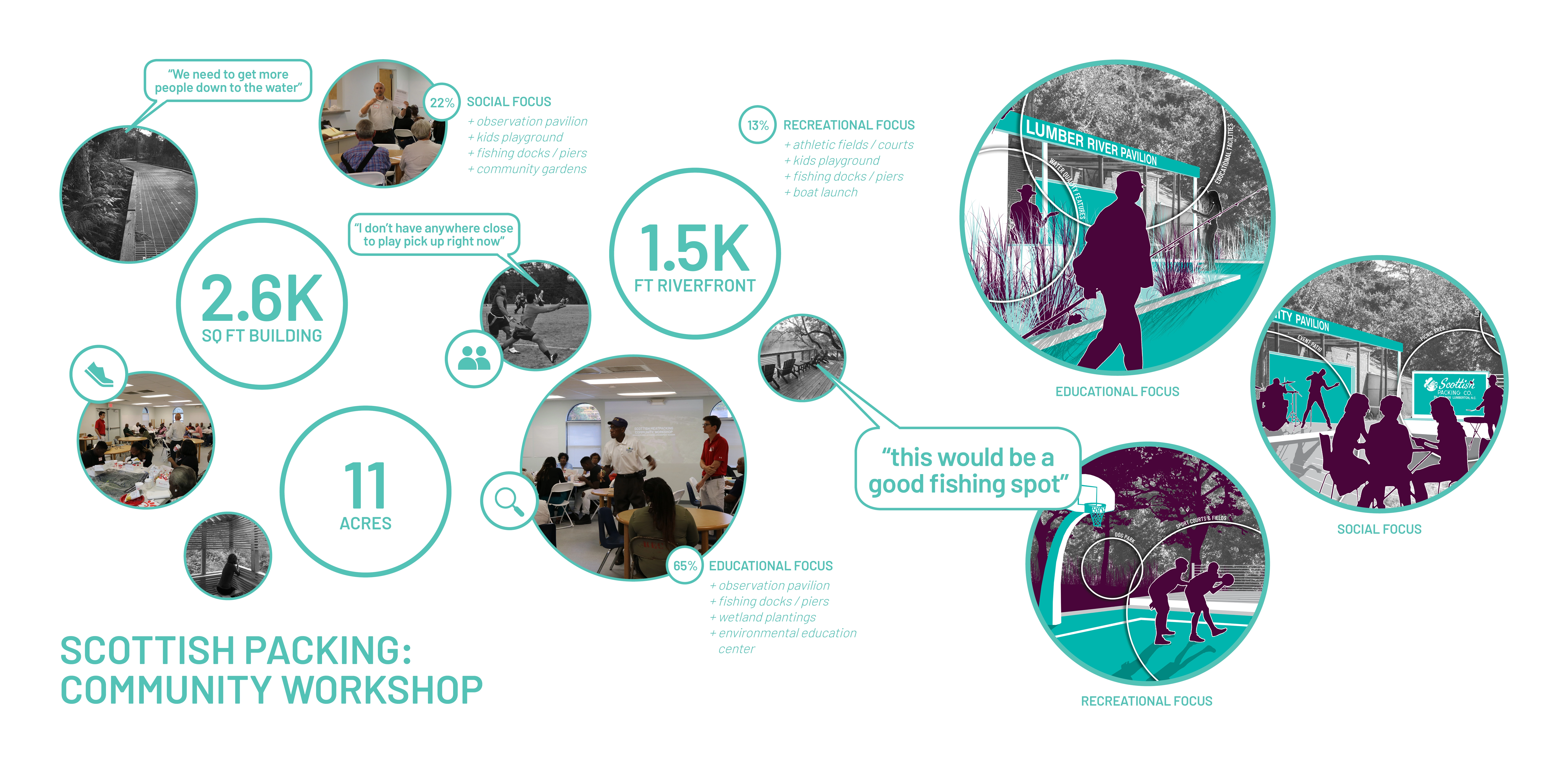
The project team worked closely with elected officials and city staff to operationalize the plan’s ambitious goals through a focused strategy of transforming the city’s vacant parcels into places for water storage, habitat and ecologically sensitive trails, parks and programs. Project recommendations are tied to existing community assets, plans and, where appropriate, county and regional recovery planning efforts and existing recreation programs. Recommendations also address a variety of spatial and temporal scales of open space planning and management within the context of disaster recovery and hazard mitigation. Lastly, the project team has led community engagement activities to support equitable design and implementation of the proposed options. This community-engaged technical assistance process has helped Lumberton build capacity to navigate the difficult tasks of rebuilding its community and recovering its relationship with the Lumber River. These actions promote adaptive design strategies that support long-term community function, health, resilience, culture and vitality.
Prioritizing Equitable Futures:
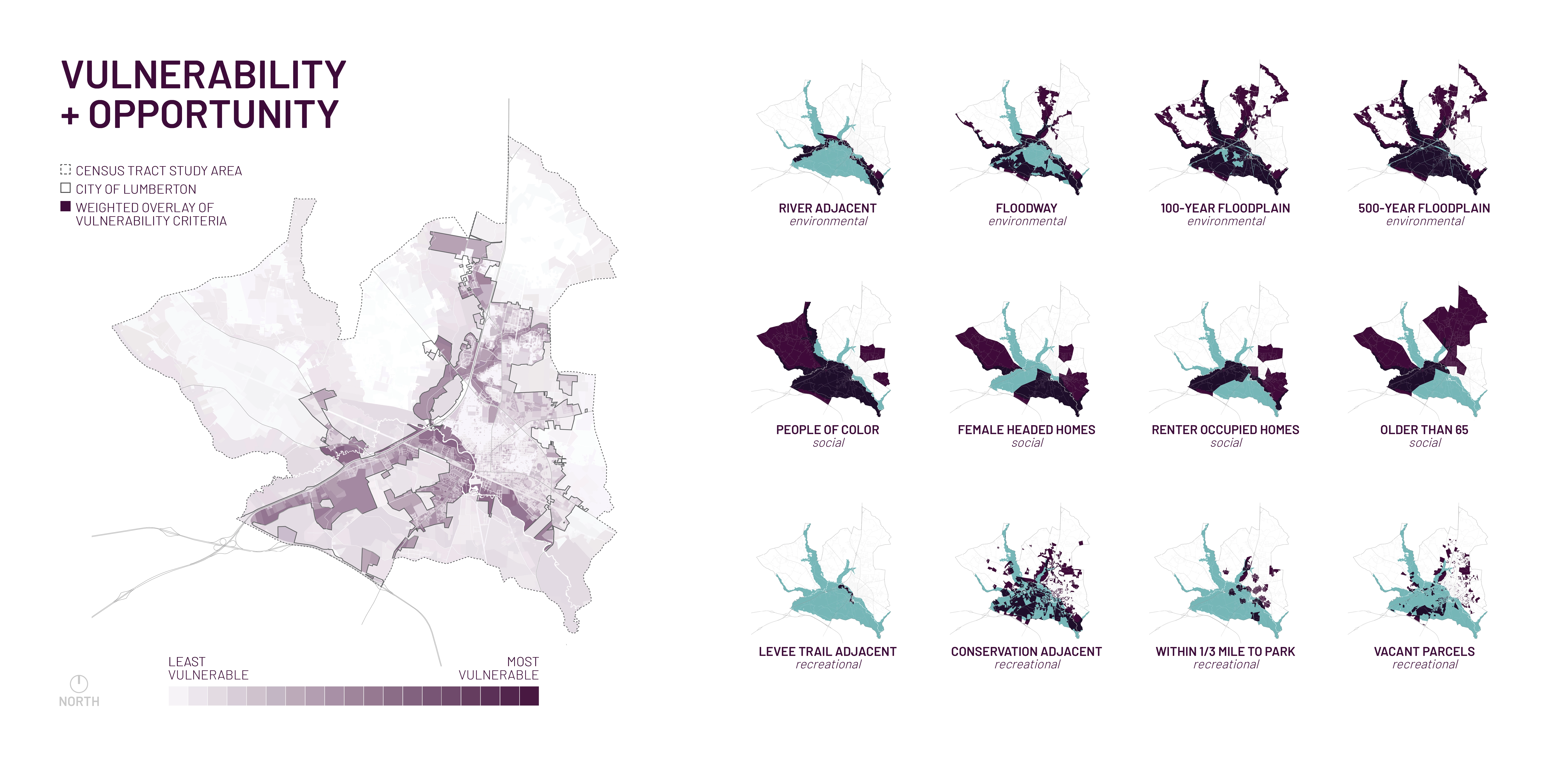
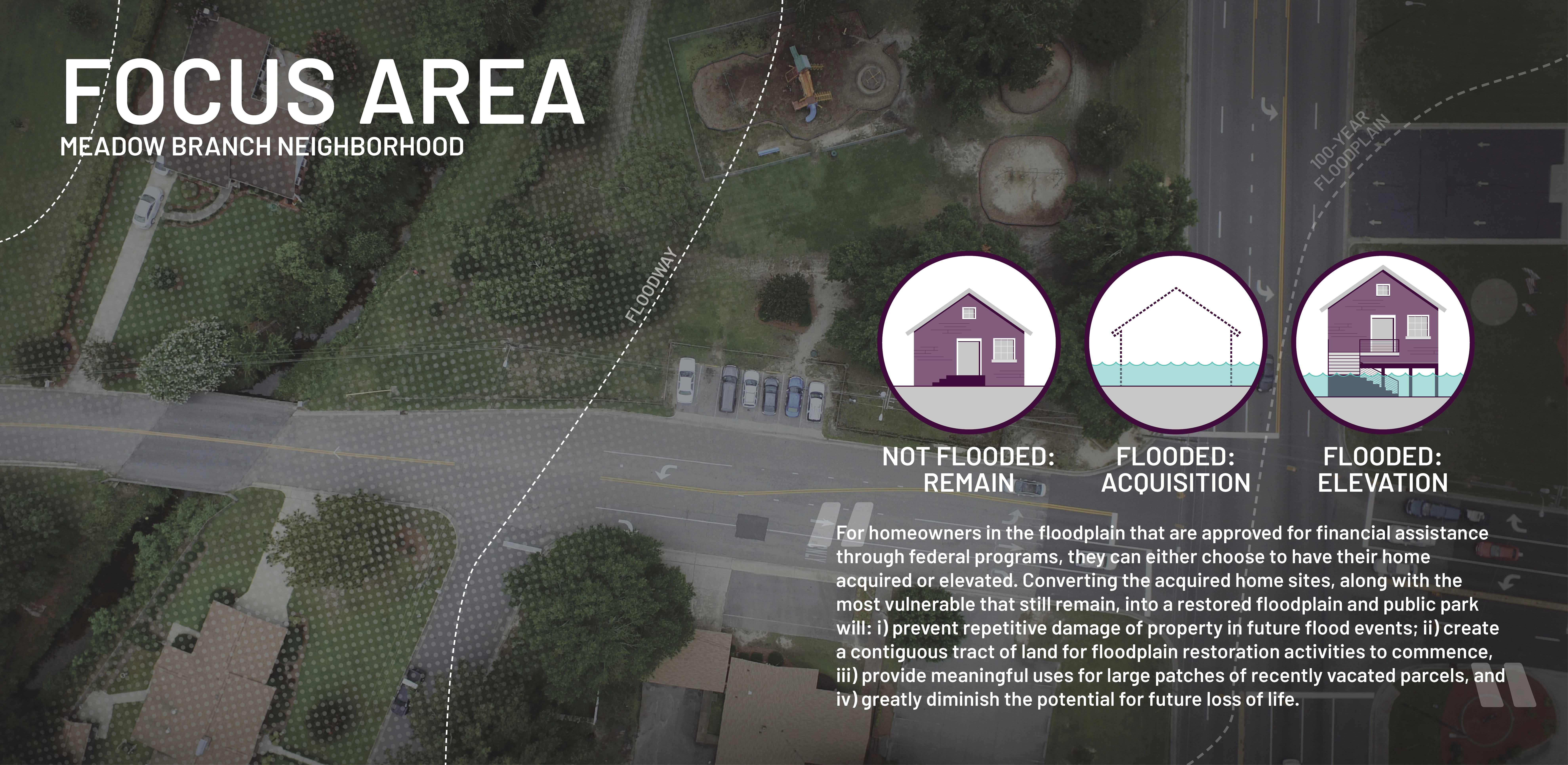
The most vulnerable people live in the most vulnerable places. Flood risk is not distributed equally across communities and correlates with a wide array of social vulnerability indicators. Communities with large numbers of low income households, people of color, seniors, young children, and other factors often find themselves in areas most affected by environmental stressors. In Lumberton, many of the city’s most socially vulnerable populations exist within the floodplain areas south of the Lumber River. These neighborhoods are artificially “protected” by a levee and lack redundant flood control measures to counteract the environmental hazards correlated with major flooding events.
The Floodprint process evaluated physical exposure and social vulnerability to environmental risks, including factors related to an individual's ability to recover. The vulnerability assessment used environmental, social and economic data to build upon a baseline land suitability analysis. Similar to many communities, various demographic groups in Lumberton are disproportionately exposed to these risks. Identifying and understanding these socio-economically vulnerable populations provided a more accurate picture of the distribution of risk, and associated “gaps” in resource allocations, which in turn guided the prioritization of neighborhood level, sub-area planning recommendations. The resulting community master plan creates more equitable access to park space and recreational opportunities while simultaneously reducing exposure to flood risk at the scales of individual house and homeowner, neighborhood block and citywide.
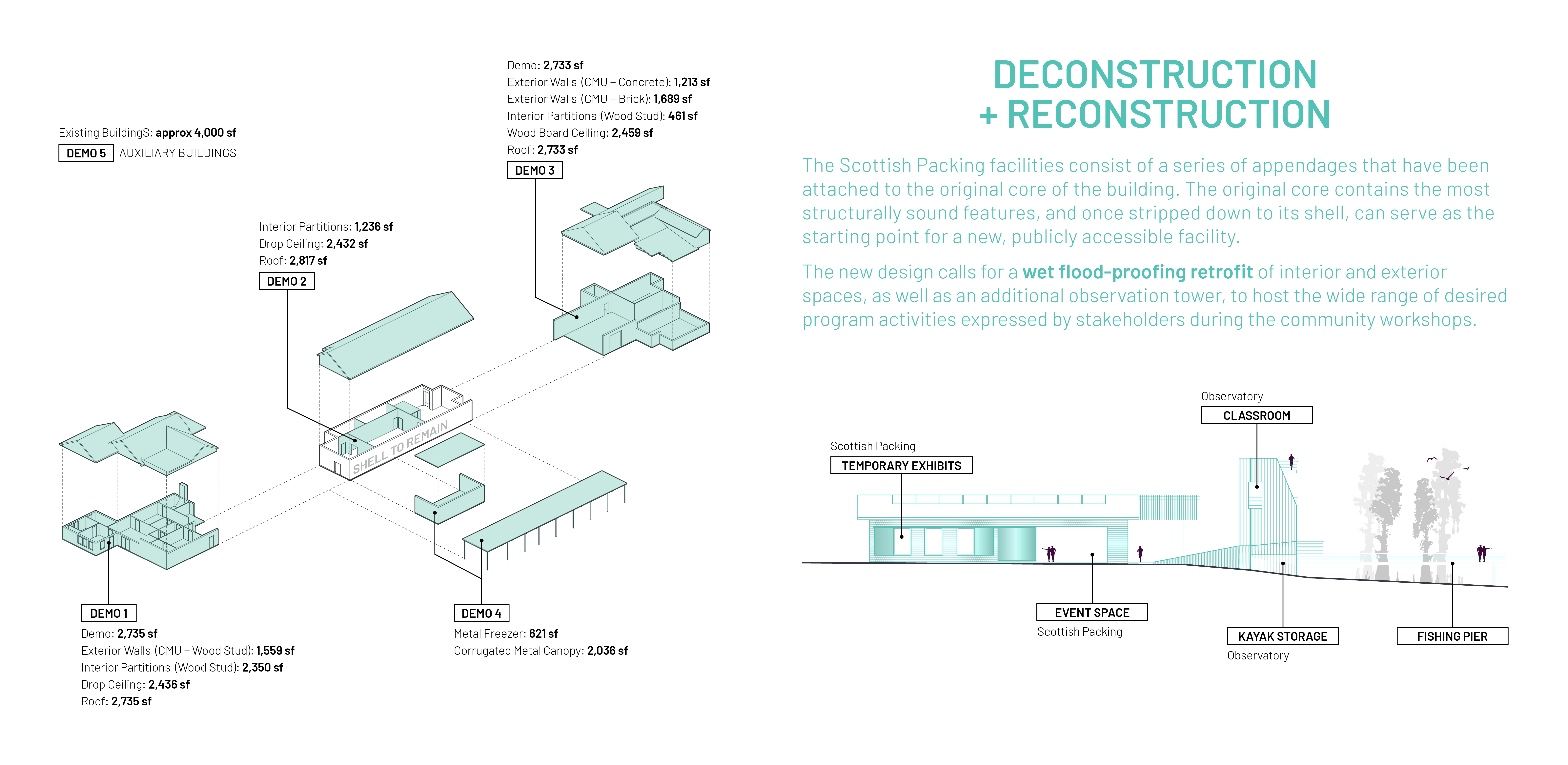
Repurposing Vacant Land for Public Benefit:
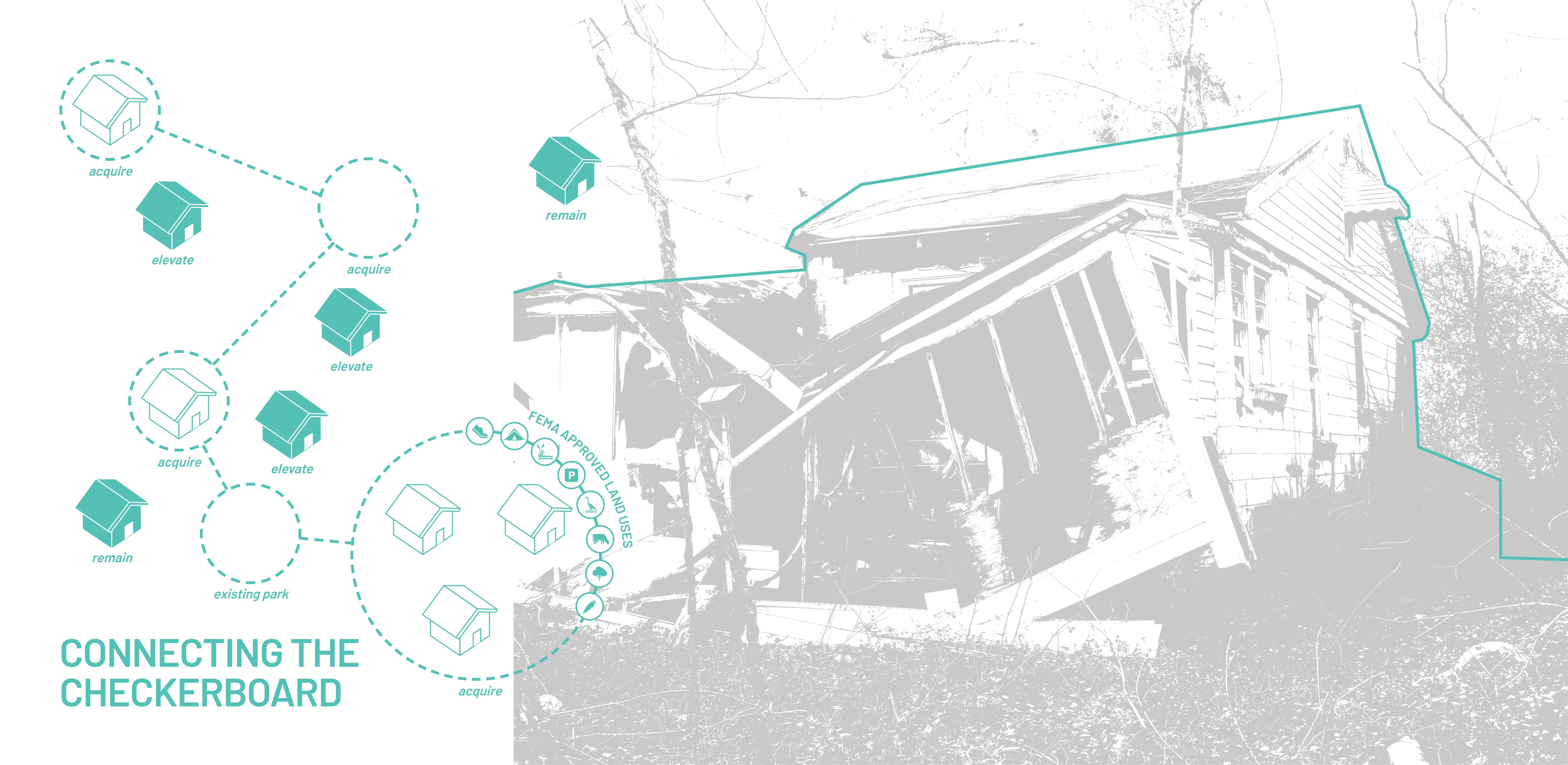
Several Lumberton neighborhoods were impacted by the catastrophic floods caused by Hurricanes Matthew and Florence. The aftermath has left a scatter-plot of vacant and/or underutilized properties throughout the city, further exacerbating existing vulnerabilities of these areas. In some cases, the City of Lumberton becomes the owner of such properties, and ultimately bears the responsibilities of upkeep and management. In rural communities like Lumberton, post-disaster decreases in tax base coupled with spatial discontinuity between vacant properties can quickly make the task of land management an overwhelming burden. Additionally, in this condition, vacant and/or flood-prone properties are not typically used in ways that serve an ongoing public benefit. Instead, vacant and/or flood-prone properties remain unprogrammed, become problematic to maintain, and are often viewed as a nuisance.
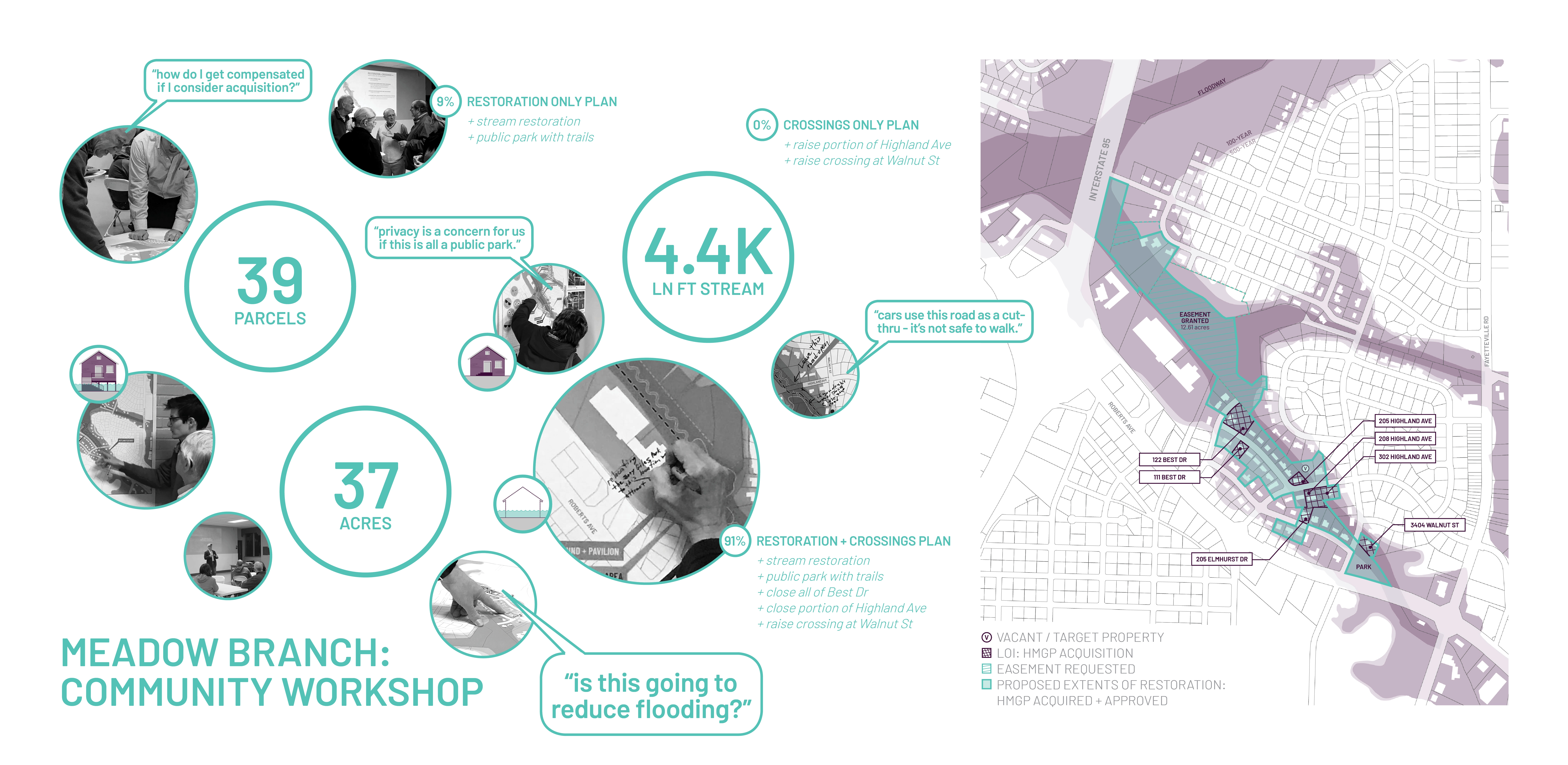
If managed properly, vacant land can serve as a catalyst for reconnecting natural systems, nurturing strong social bonds, and providing essential ecosystem services to areas undergoing transformation. In order to realize these benefits, the project team evaluated Lumberton’s vacant lands in the context of the entire community’s landscape. This informed larger planning and design strategies, and aligned proposed designs/programs with existing community planning documents/initiatives. These analyses also enabled a system-wide understanding of critical issues, such as: vulnerability to flooding (including causes), ecological significance, and asset connectivity (existing and potential). Once these criteria were mapped, issues and opportunities related to management of vacancies within the system were prioritized.
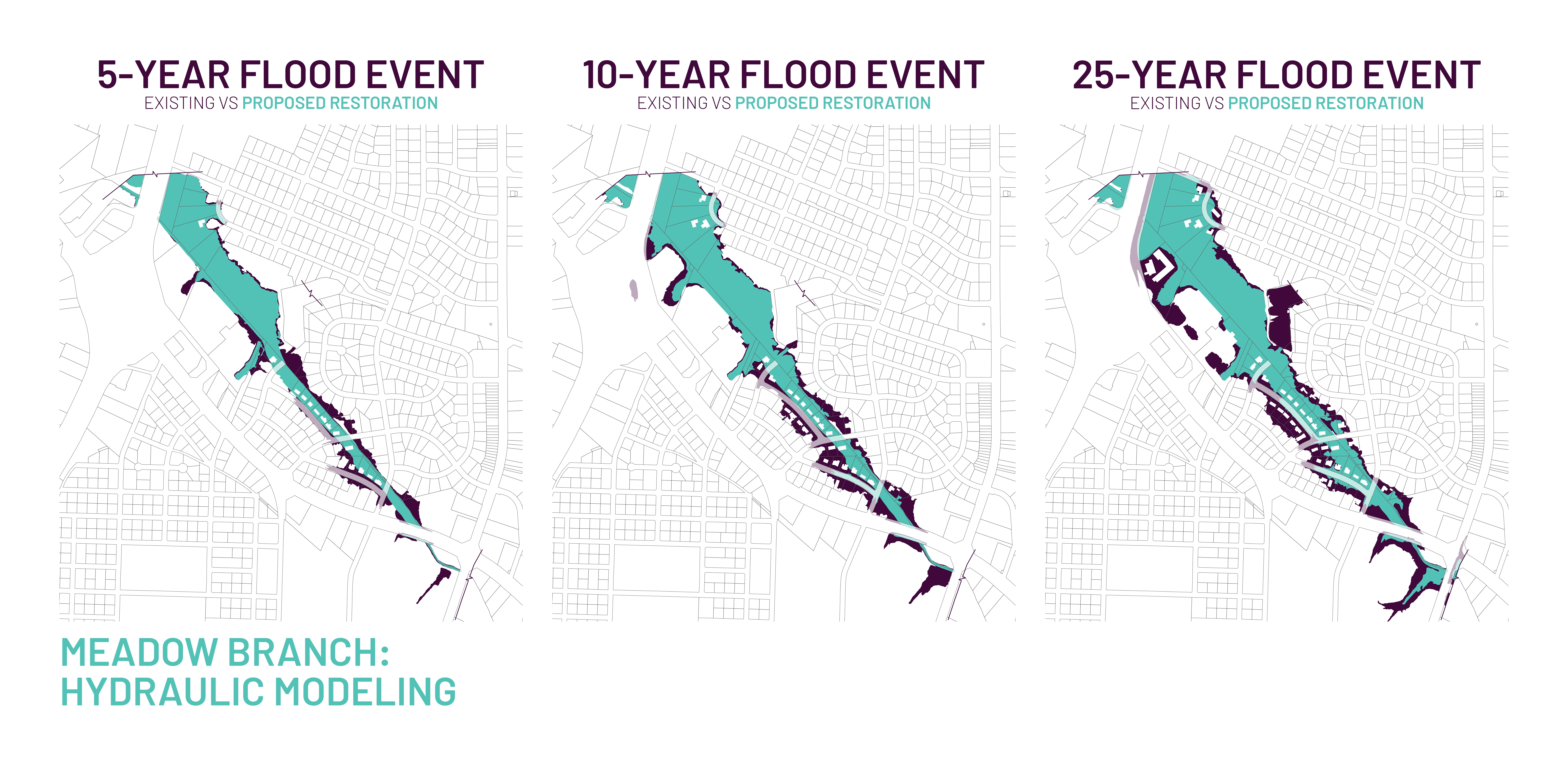
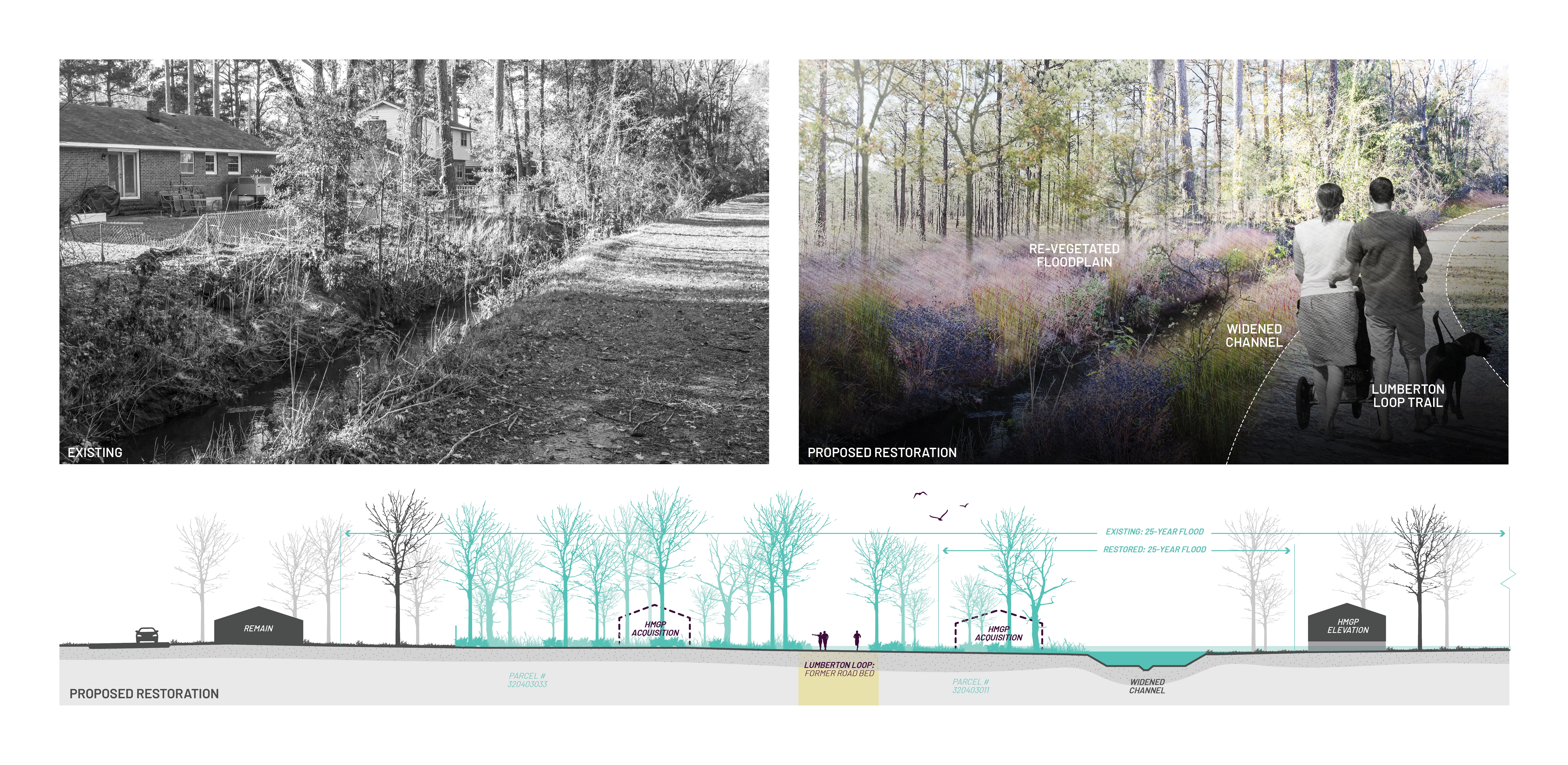
Lastly, illustrative methods were developed to clearly and concisely illustrate “buy-out” alternatives, computationally modeled stream restoration scenarios, and resultant land-use recommendations. These simplified, highly communicative graphic methods played an instrumental role in informing the decisions of individual property owners, neighborhood groups, and city staff and elected officials. The results have been transformative — ongoing collaborations with residents and city staff to co-design and implement projects have increased the speed of disaster recovery and resiliency planning activities and continue to guide the city in optimistic and opportunistic directions.
Closing the Loop — Recovery, Recreation, Resilience:
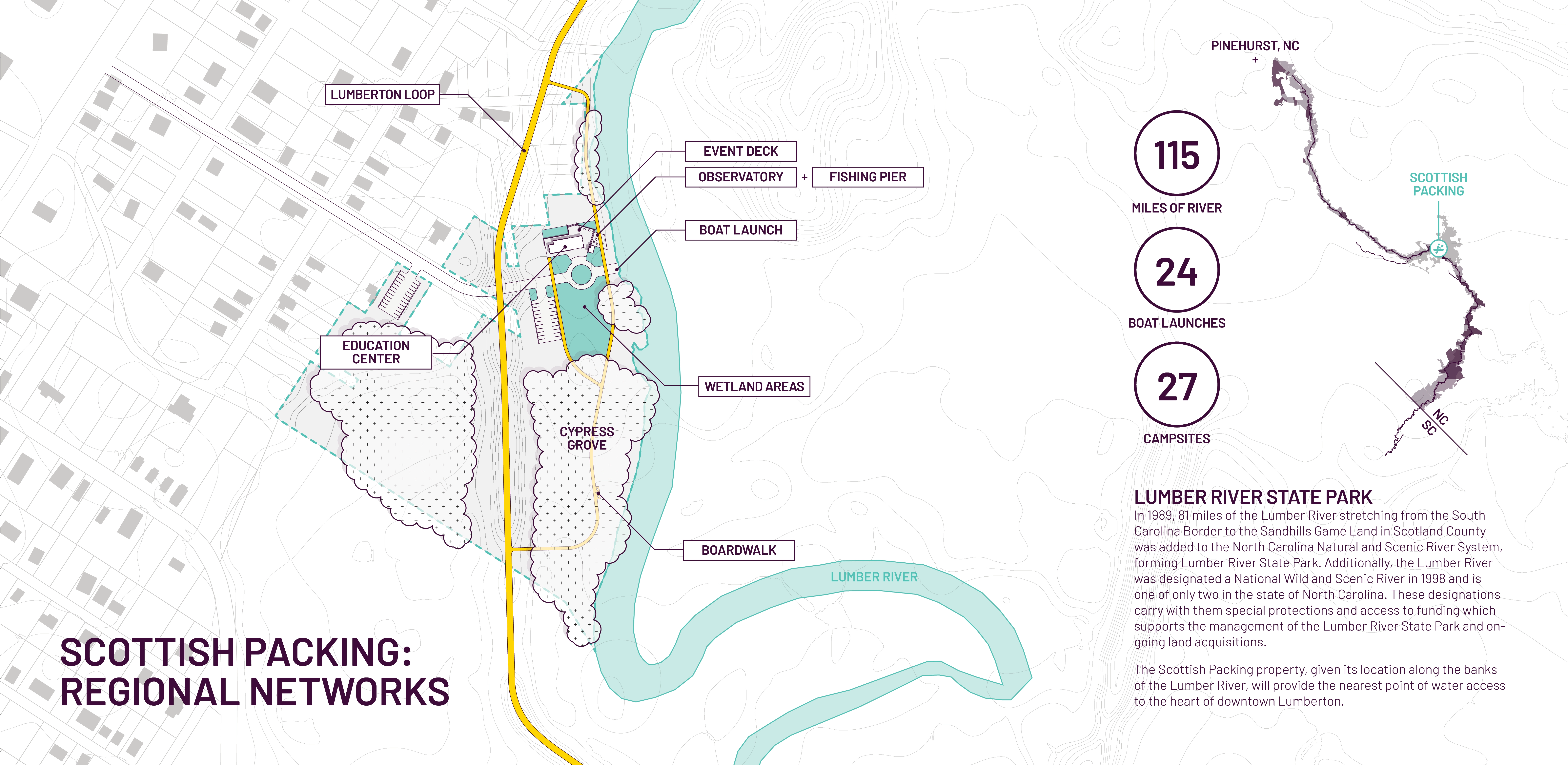
The highest and best use of land within a floodplain is to serve its natural function – attenuate flooding through the capture, absorption and slow release of rising waters. At the time of the initial community engagements, floodplains were commonly, and solely, viewed as environmental hazards. As discussed, these same areas hold the potential to serve as public amenities through the provision of active recreation and ecosystem services, especially when connected to existing land holdings held by the city, state, and conservation groups. While buyout parcels, conservation easements, and city/county parks in Lumberton are often located in environmentally sensitive floodplain areas, these land holdings are disconnected and incapable of providing an integrated, citywide nature-based amenity. Leveraging all of the robust analyses, the Lumberton Community Floodprint developed a citywide plan, coined the “Lumberton Loop”, that aggregates these lands into a collective whole to provide a landmark recreational and flood infrastructure asset for the city. The plan organizes 108 fragmented parcels into a citywide trail network that connects 806+ acres of vacant lands, over 99% of which are located in the 100-year floodplain. The Lumberton Loop greenway system also connects each of the report’s focus areas.
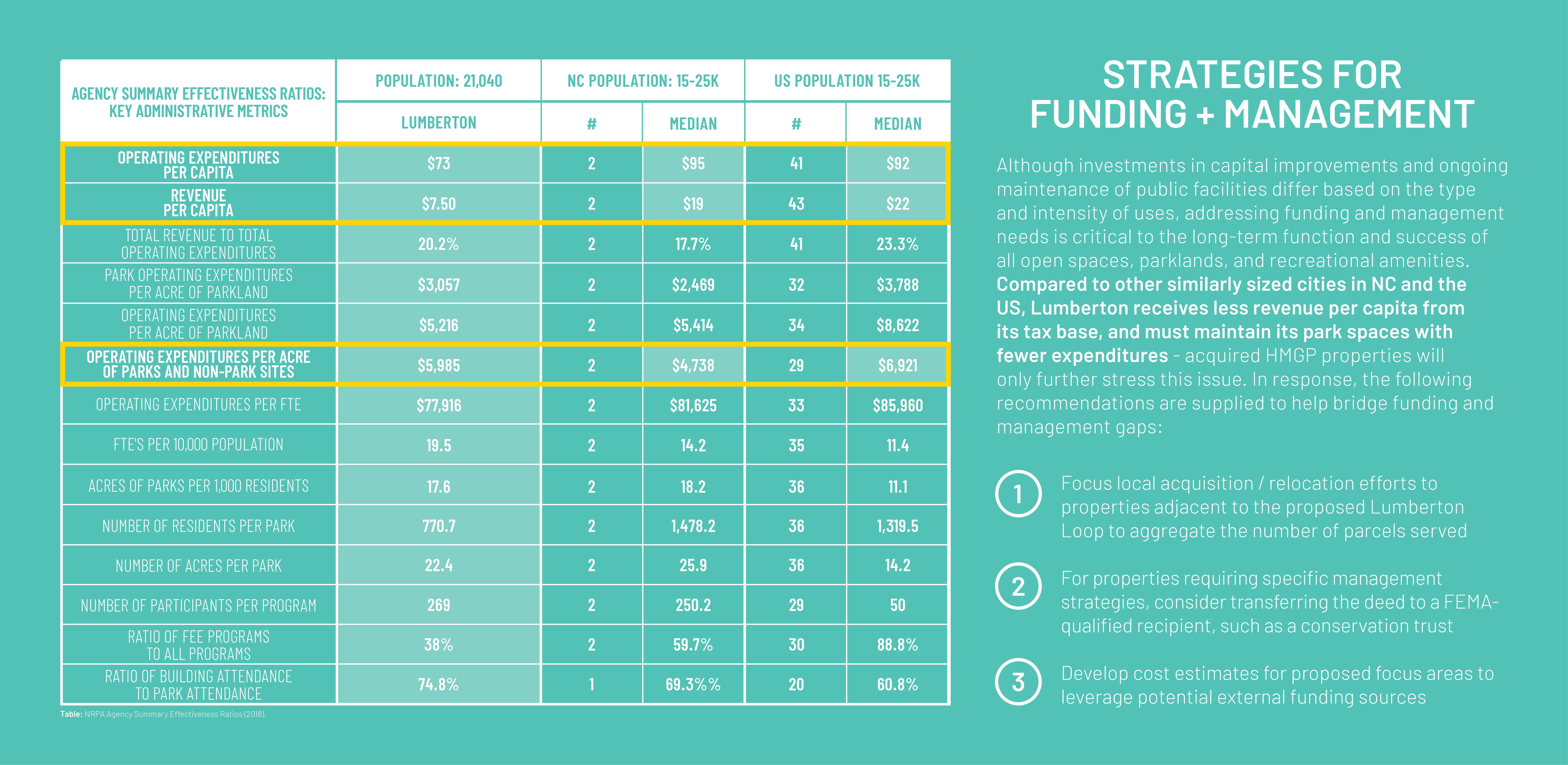
More than a static plan, the Lumberton Community Floodprint established customizable, highly adaptive strategies for repurposing buy-out properties into natural infrastructure assets. The results are ongoing planning, design and implementation of communal greenspaces that mitigate flood risks, sustainably manage stormwater, and promote active and passive uses such as recreation and physical activity, community events, environmental education, habitat restoration and river-based eco-tourism. -
- Andrew Fox, FASLA, PLA - Principal Investigator/Project Lead
- Travis Klondike, Associate ASLA - Co-Principal Investigator/Project Manager
- Kofi Boone, ASLA - Co-Principal Investigator
- Tania Allen - Co-Principal Investigator/Graphic Design
- M. Brandon Love, AIA - City of Lumberton Deputy City Manager
- Sara Queen, AIA - Co-Principal Investigator/Architecture
- Robby Layton, PhD, FASLA, PLA, CPRP - Consulting Advisor/Parks and Recreation Management
- Teresa Penbrooke, PhD, MAOM, CPRE - Consulting Advisor/Parks and Recreation Management
- Barbara Doll, PhD, PE - Co-Principal Investigator/Hydraulic Engineering
- Jack Kurki-Fox, PhD - Co-Principal Investigator/Hydraulic Engineering
- Madalyn Baldwin, Student ASLA - Graduate Research Assistant
- Benjamin Jones, Student ASLA - Graduate Research Assistant
- Brenna Laffey, Student ASLA - Graduate Research Assistant
- Joshua Basham - Graduate Research Assistant
- Kirsten Benson - Graduate Research Assistant
- Leslie Ann Jackson - Vice President of Community Investment & Engagement, North Carolina Community Foundation
Advertisement
Related Awards

Honor Award, Analysis & Planning
A Cultural Approach: The Fort Peck Tribes Hazard Mitigation Plan
In collaboration with the Fort Peck Assiniboine and Sioux Tribes, EPA, and FEMA, the Fort Peck Tribes Hazard Mitigation Plan (HMP) adopts a culturally responsive approach to hazard mitigation planning that features connection to place.


Related Articles

Landscape Architecture Magazine
LAM Wins Five ASBPE Awards
Landscape Architecture Magazine earned national and regional honors for editorial excellence, publication design, and profile.
Jun 1 2026