
.webp?language=en-US)


From Risk to Productivity: A Successional Salty Agriculture System in the Pearl River Delta
Xiaohao Yang, Student International ASLA; Wanwen Chen, Jing Huang, Jiahua Zou

This extraordinarily far-reaching plan addresses the long-term prospect of catastrophic sea-level rise in China’s Pearl River Delta that is the inevitable effect of climate change. Facing an issue of enormous complexity in one of the most densely populated regions in the world, the planners have proposed a phased 80-year adaptation strategy that first transforms the agricultural economy in the tidal flats to aquaculture, then over time replaces tidal flats with salt marshes, and finally implements a mixed marsh and mangrove scheme of floating platforms, fisheries, and biogas power generation. This sophisticated and refined plan seeks to preserve the local culture by offering a constructive response to what otherwise would be a devastating reality.
Awards Jury
-
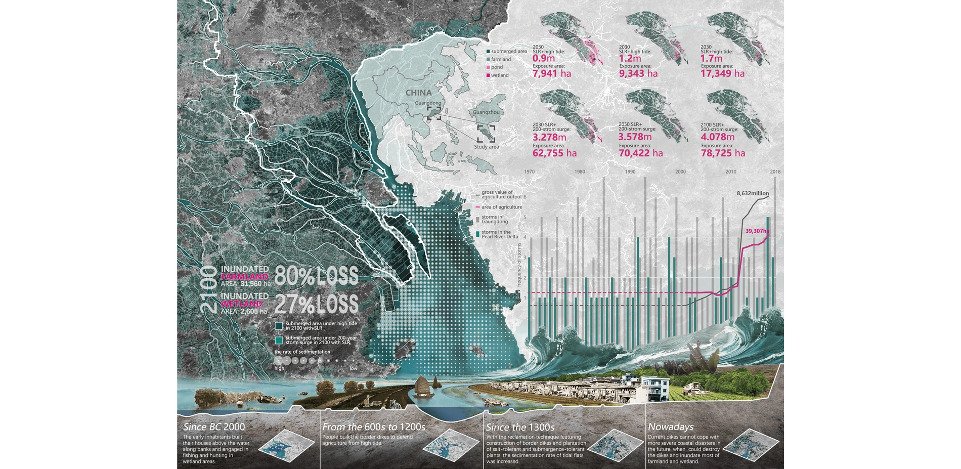
The study area is in Guangzhou, the Pearl River Delta, China, a region with a complex landscape system featuring agricultural production and wetland. The coastal disasters such as storm surge and seawater intrusion have always been a risk for most of the agricultural land, which is lower than the local mean sea level. Therefore, an adaptive agriculture model is needed to deal with the greater risk caused by sea level rise.
Based on traditional reclamation agricultural model, our proposal is to integrate agriculture production with wetland transformation under sea level rise to create a successional salty agriculture landscape adapting to coastal environmental change and benefit agriculture, ecology and social culture for the next 100 years.
Our proposal includes three phases:
- transforming the original agriculture to aquaculture on the tidal flat;
- cultivating salt marsh on tidal flat to build a rotation of harvest agriculture and aquaculture;
- replacing part of spartina with mangrove in a successive way to create a mixed rotation of fishery, harvest agriculture, aquaculture and wetland conservation.
-
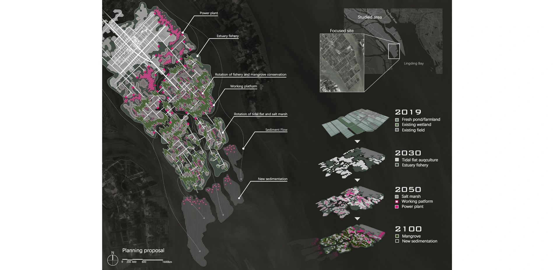
1. An Overview of Study Area
Known for historic reclamation agricultural area, the development of land in the Pearl River Delta is formed by the interaction of natural sedimentary process and agricultural development. The study area is Guangzhou coastal area along the west coast of the Lingding Bay in the Pearl River Delta. This area features agricultural production and wetland.
The west coast of the Lingding Bay is a sedimentary area where silt deposits quickly, providing the basis for reclamation agriculture. Since the BC 2000, the early inhabitants built their houses above the water along banks and engaged in fishing and hunting in wetland areas. From the 600s to 1200s, people built the border embankments to defend agriculture from high tide. Since the 1300s, with the development of reclamation technique on construction of embankments and plantation of salt-tolerant and submergence-tolerant plants, the sedimentation rate of tidal flats was increased. Large areas of tidal flats have been developed in the Pearl River estuary for the agricultural expansion. Consequently, the coastal agriculture landscape of Guangzhou gradually spread to the sea.
With natural sedimentary process and embankments, this traditional wetland reclamation agriculture not only formed new farmlands continuously but also created transitional wildlands, the coastal wetland that would be eventually replaced by farmlands and intensive fish ponds. As a result, a mixed landscape system below mean tidal level creating by traditional agriculture model was mainly depended on the protection of the embankments.
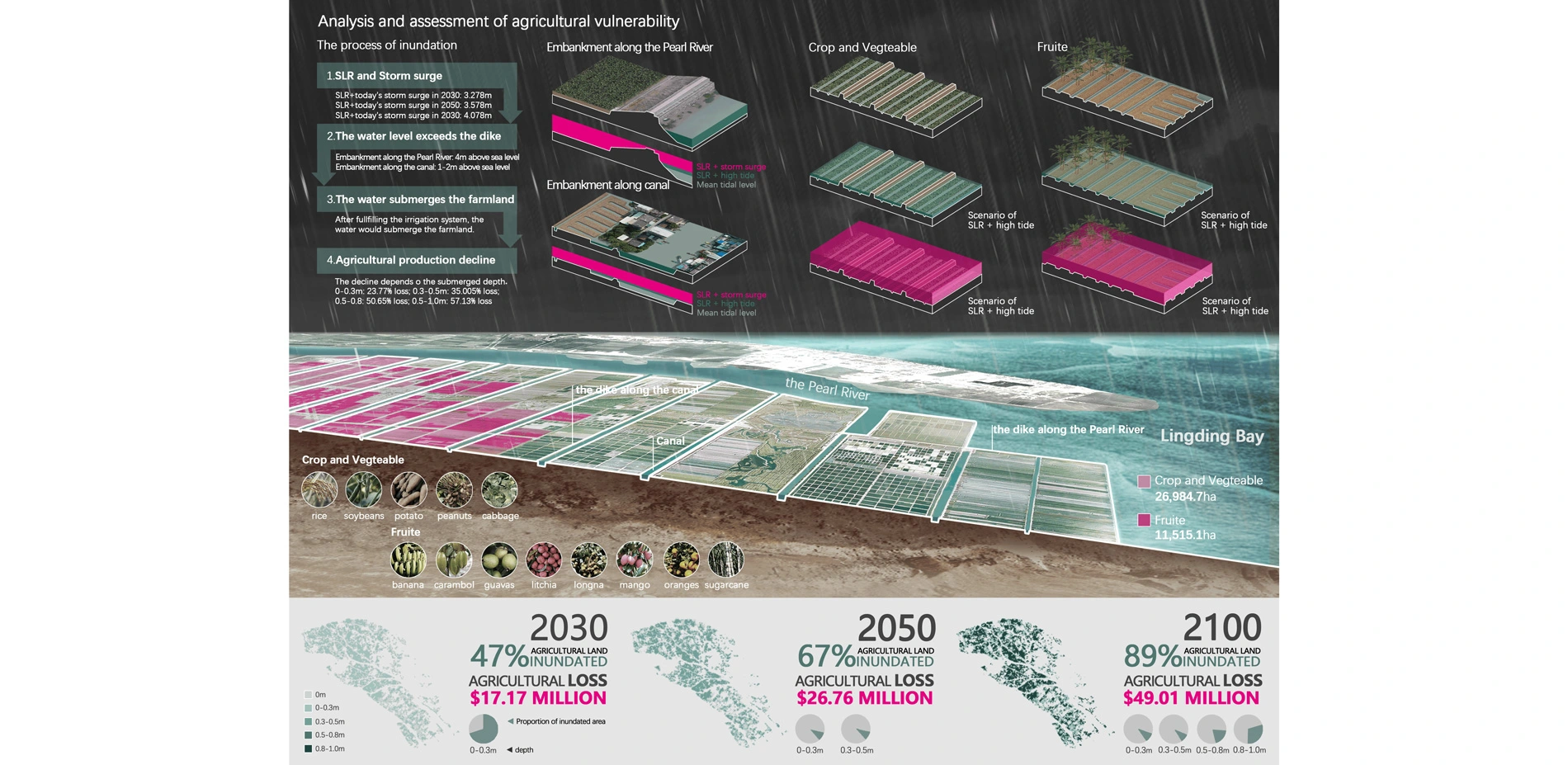
According to Climate Change 2014: Synthesis Report of IPCC, the global mean sea level will possibly rise about 1m by 2100. Existing embankments and agricultural infrastructure are vulnerable to more severe coastal disasters in the future as sea level rise (SLR) will lead to more intense and frequent storm surges, which could destroy the embankments and inundate most of farmland and wetland. Nowadays, there are more agricultural lands being created, bringing more economic benefit, and the agriculture still plays a dominant role in economy. Nevertheless, both economy and environment will be destroyed by SLR.
2.Dynamic Assessment of Agricultural Vulnerability and Wetland Adaptivity
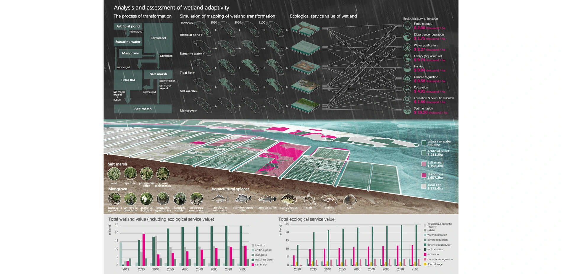
As an artificial landscape, coastal agriculture landscape in Guangzhou spatially overlap within parts of wetland—ponds and tidal flat. Therefore, agriculture and wetland should be regarded as a complex landscape system. Based on multiple indexes of economic value, this design focuses on assessing agricultural vulnerability and wetland adaptivity, and simultaneously taking the dynamic impact of SLR on the landscape system and the succession of wetland into consideration.
The assessment is based on two models:
- GIS Based Inundation Model, which analyzes and mappings the loss of agriculture under different SLR scenarios;
- Sea Level Affecting Marsh Model, which simulates dynamic process of transformation and migration of wetlands under SLR, in order to analyze the changes of the ecological service value of wetlands.
The dynamic analysis focusing on the types of agriculture and wetland are as follows:
- agriculture: vegetable and fruit farming, aquaculture;
- wetland: estuary open water, tidal flat, salt marsh, mangrove and inland open water.
The assessment of agricultural vulnerability and wetland adaptivity includes:
- lost crop yields due to inundation;
- ecological service function: fishery production, climate control, flood storage, purification, habitat, adjustment for interference, siltation promotion, entertainment and research.
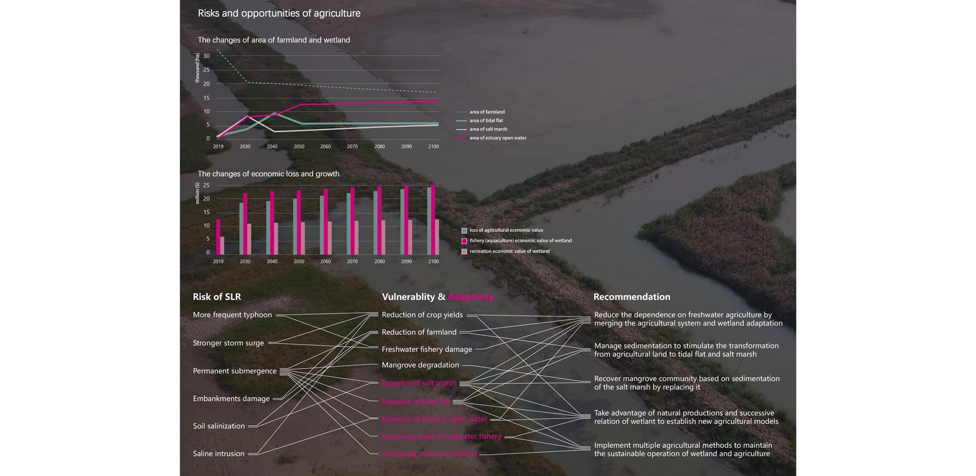
Based on the above assessment models, the wetland is possible to replace the existing agricultural areas because of the natural transformation and migration. Accordingly, the ecological service value of changing wetland would compensate for the lost value of agriculture, which naturally adapt to the impact of rising sea level. Therefore, SLR is both a challenge and an opportunity for the landscape system. Through the dynamic analysis of various types of wetland, some basic recommendations are proposed as follows:
- gradually reducing the dependence on irrigation agriculture and freshwater aquaculture by intergrating the agricultural production system with wetland adaptative capacity.
- adjusting and managing sedimentation to stimulate the transformation from agricultural land to tidal flat and salt marsh;
- recovering mangrove community based on sedimentation of the salt marsh;
- taking full advantage of natural productions and successive relation of tidal flat, salt marsh and mangrove, etc. to establish new agricultural models that can be operated in different ways and cycles, and be mutually connected and contributive;
- implementing multiple methods to utilize new agricultural products to maintain the sustainable operation of wetland and agriculture.
3.Creating a Successional Salty Agriculture System with the wetland transformation over time
As the impact of SLR on coastal environment is an ever-change process, the fixed agricultural landscape planning is difficult to respond to coastal changes to survive and keep working in the future. The concrete coastal hard engineering infrastructures block the dynamic connection between landscape system and marine environment, and simultaneously with greater risk leading to increasing losses. Inspired by the strong adaptative capacity of wetlands to transform under SLR, the design hence improve the ability of transformation to provide agriculture with a motive force compatible with SLR. This coastal wetland-driven agriculture model would turn the risk of inundation to opportunities for future production. With sea level rising, successional salty agriculture model can create new value of agriculture, ecology and social culture by forming various agricultural systems, each of which has roles to perform and benefits each other within different submerging regions.
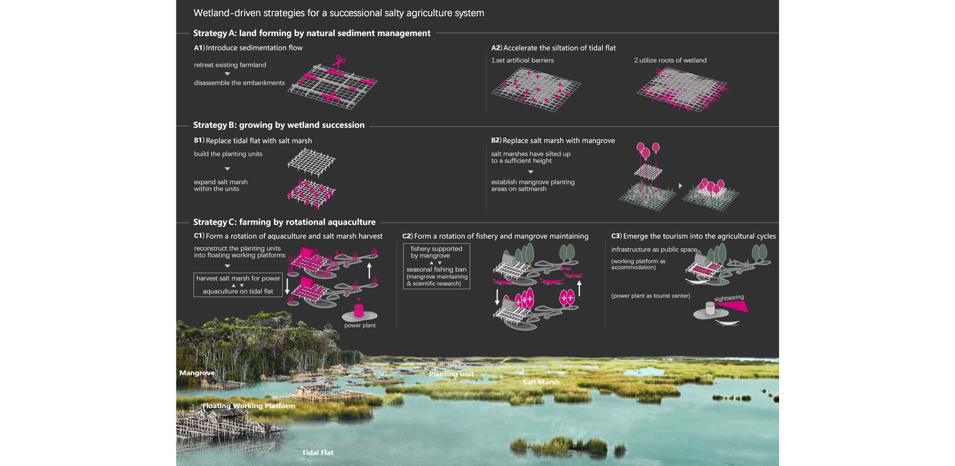
Based on traditional wetland reclamation agriculture model and the basic recommendations proposed in dynamic analysis, three key strategies are proposed to create the successional salty agriculture:
- Strategy A: land forming by natural sediment management
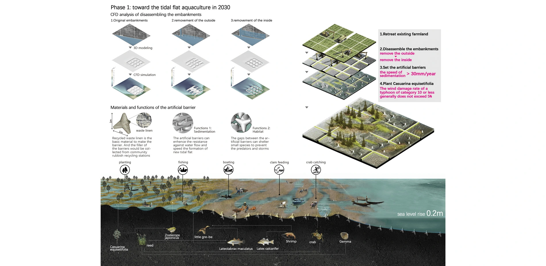
- a1) retreating existing farmlands to introduce sedimentation from the Pearl River into the existing agricultural region as sea level rising by disassembling the ridges;
- a2) accelerating the siltation of tidal flat by intercepting silt with artificial barriers and the roots of wetland;
- Strategy B: growing by wetland succession
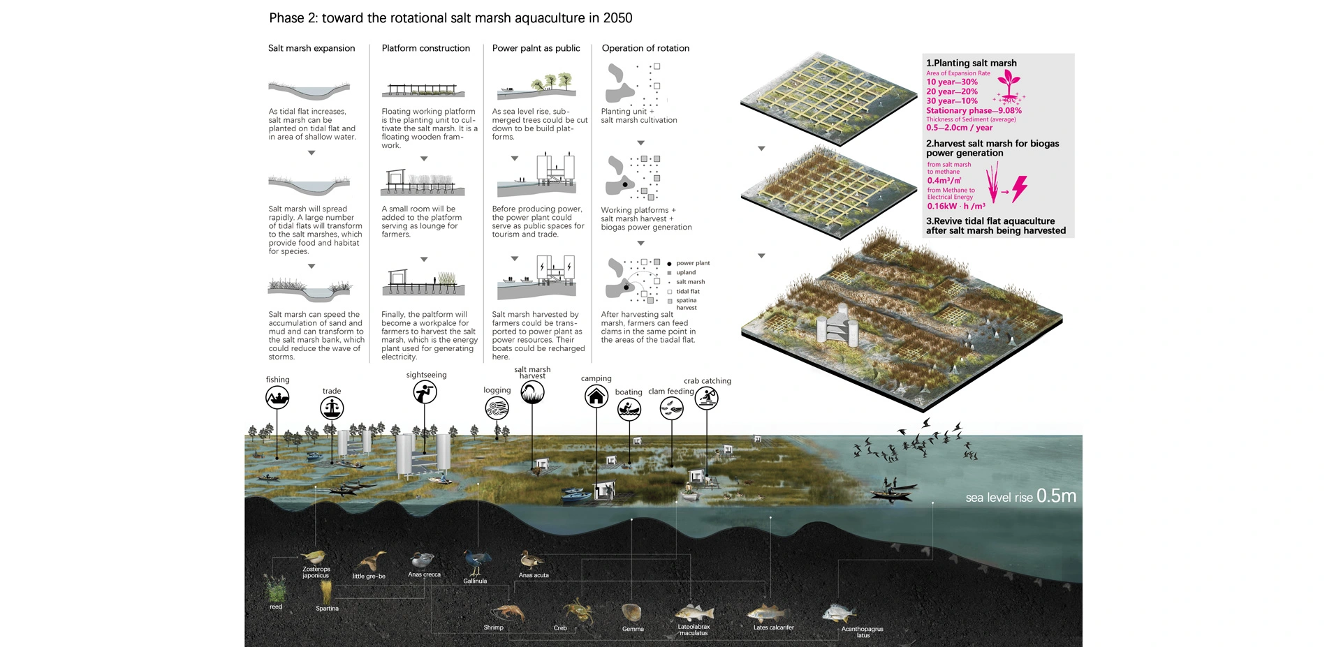
- b1) building the frameworks of planting unit on the inundated tidal flats to replace them with salt marsh;
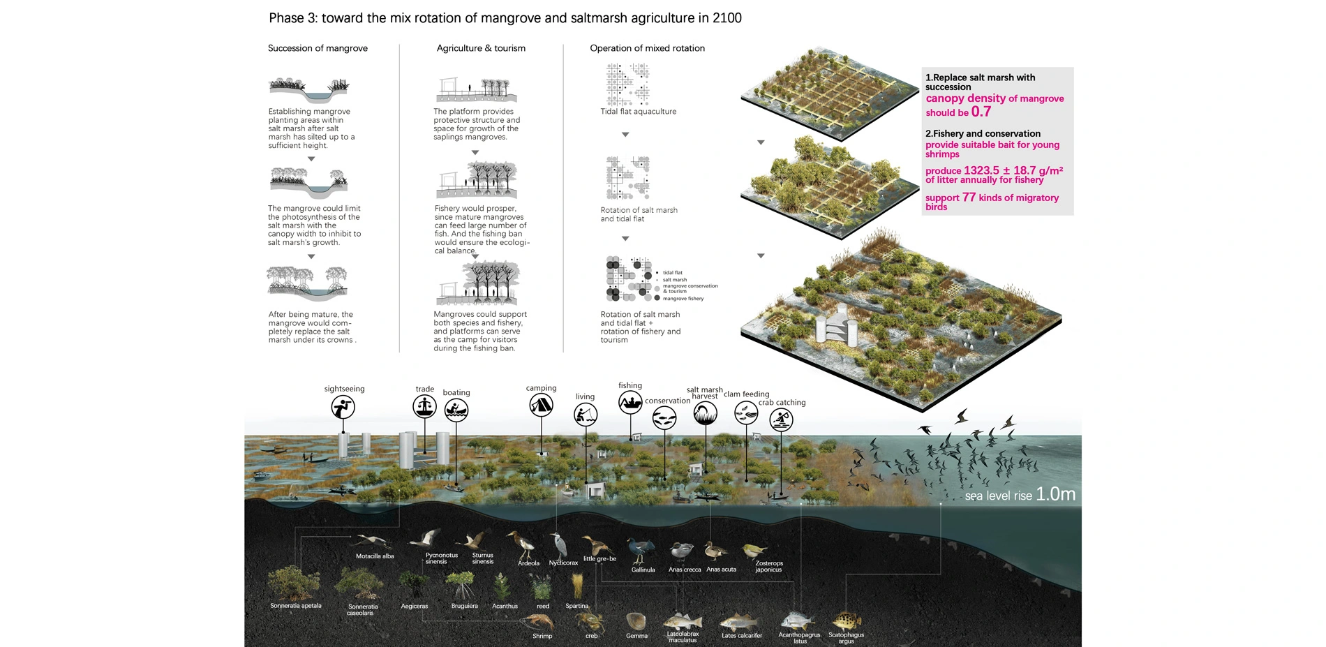
- b2) based on the frameworks of planting unit, establishing mangrove planting areas within saltmarsh after salt marsh has silted up to a sufficient height, and gradually replacing salt marsh in the high intertidal zone by limiting the photosynthesis of the spartina with mangrove canopy width, remaining the spartina that grows within the deeper inundated areas;
- Strategy C: farming by rotational aquaculture
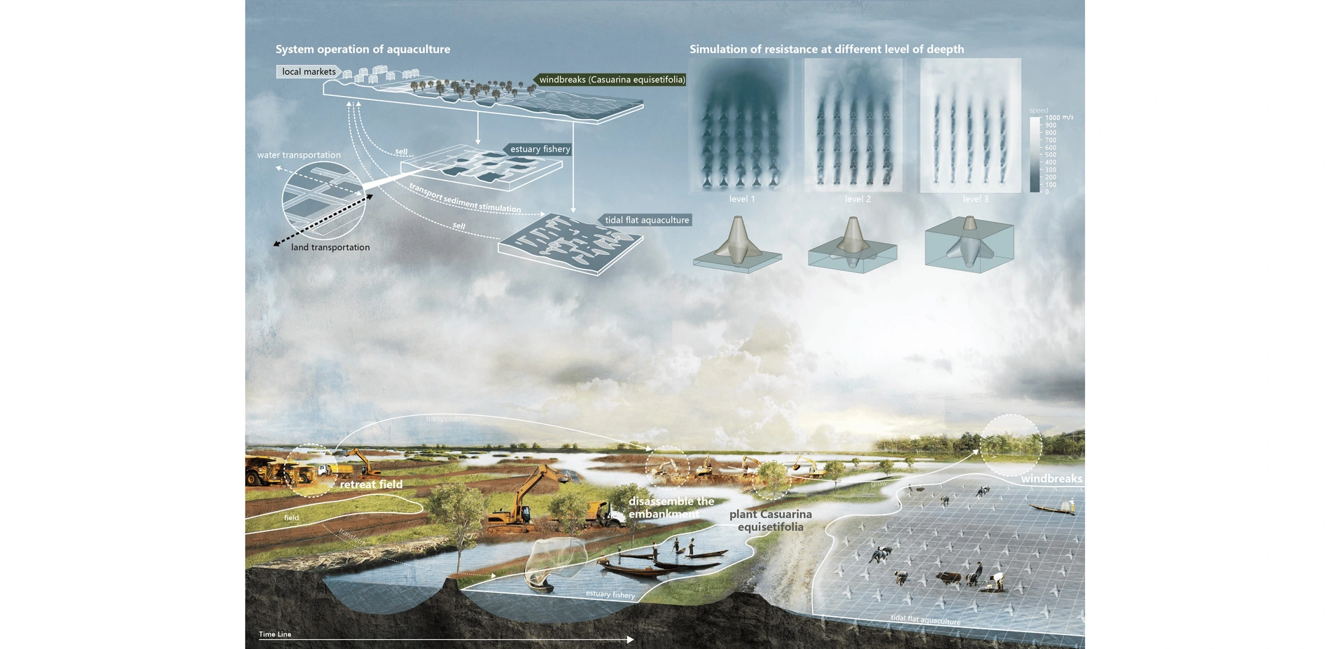
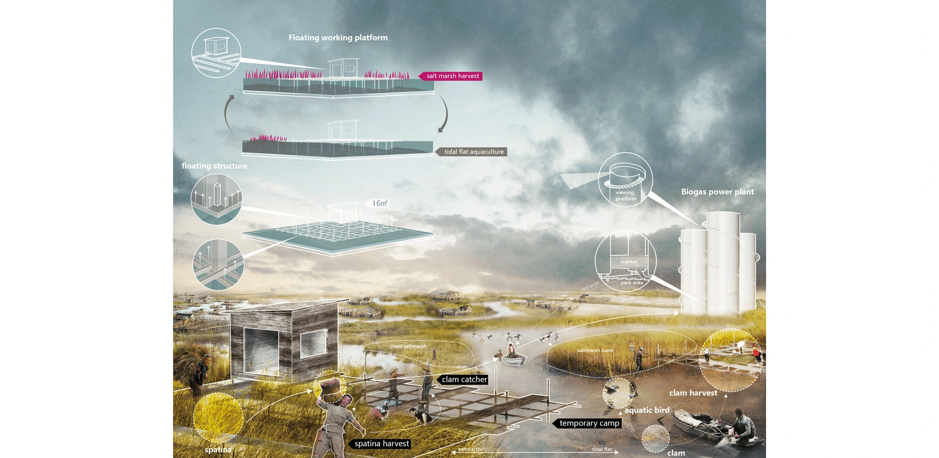
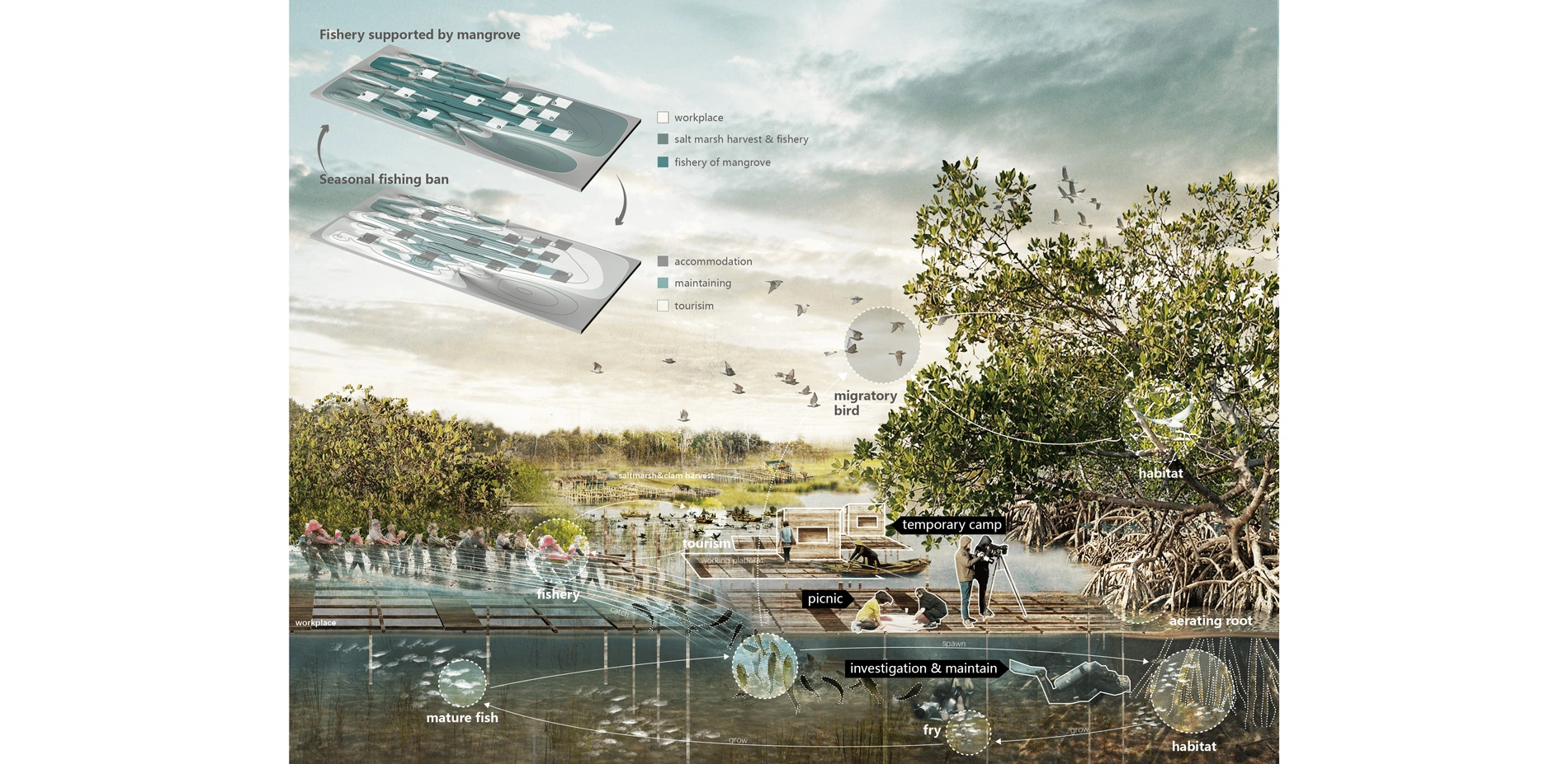
- c1) reconstructing the frameworks of planting unit into the floating working platforms to harvest the salt marsh growing on the tidal flats for biogas power generation, pharmaceutical industry and feed production, and running aquaculture on the tidal flats where the salt marsh has been harvested; then, harvesting the salt marsh until it grows up again; repeating the above cycle to form a rotation of aquaculture and harvest;
- c2) forming the rotation of fishery and mangrove maintaining by developing fishery based on the shelter and nourishment provided by mangrove habitats, and implementing a seasonal fishing ban to scheduling researchers to maintain and study on wetlands;
- c3) emerging the tourism into the cycles of the various agricultural activities, and utilizing the floating working platforms as accommodations for visitors.
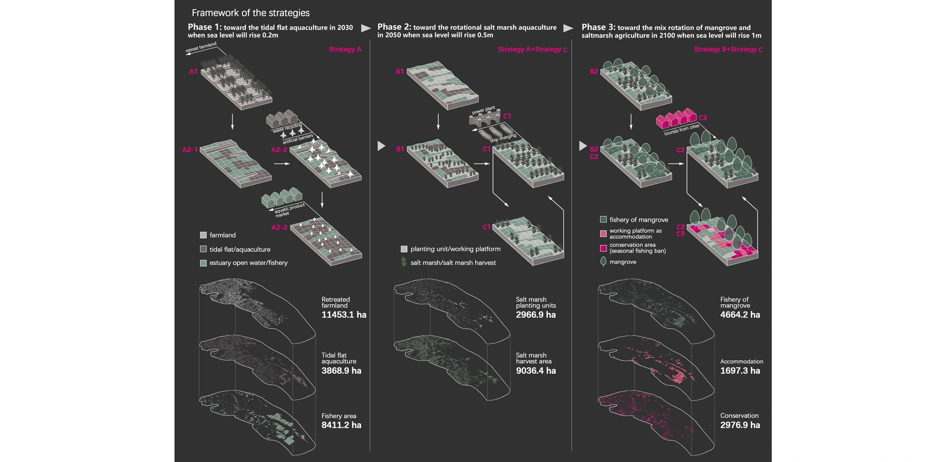
According to the above strategies, the existing agriculture would be transformed by taking following phases:
- phase 1: toward the tidal flat aquaculture in 2030 when sea level rise by 0.2m;
- phase 2: toward the rotational salt marsh aquaculture in 2050 when sea level rise by 0.5m;
- phase 3: toward the mix rotation of mangrove and saltmarsh agriculture in 2100 when sea level rise by 1m.
-
- Xiaohao Yang, Chongxian Chen, Yu Xia
Advertisement
Related Awards

Honor Award, Analysis & Planning
A Cultural Approach: The Fort Peck Tribes Hazard Mitigation Plan
In collaboration with the Fort Peck Assiniboine and Sioux Tribes, EPA, and FEMA, the Fort Peck Tribes Hazard Mitigation Plan (HMP) adopts a culturally responsive approach to hazard mitigation planning that features connection to place.

