.webp?language=en-US)


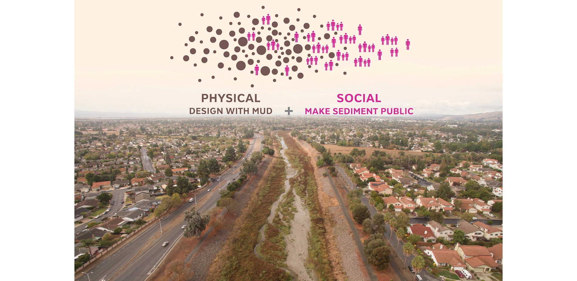

This proposal for the San Francisco Bay Area recognizes the importance of allowing sediment to flow from streams into the marshes and mudflats of tidal ecosystems as a means of maintaining healthy communities and to combat rising sea levels caused by climate change. Created with significant community input, this paradigm-shifting plan recommends the redesign of the Alameda Creek to better transport sediment, provide fish habitats, and create opportunities for public spaces along the waterway. It helps puts the issue on the agenda for landscape architects and treats sediment not as waste but as one of the most valuable things we can hold on to as coastal processes are changing.
Awards Jury
-
The Bay Area's tidal ecosystems—its marshes and mudflats—are at risk of subsidence and drowning with low sediment supply and sea level rise. Public Sediment for Alameda Creek proposes that sea level rise adaptation must extend upstream, redesigning sediment flows to sustain tidal ecosystems and protect vulnerable communities. Public Sediment for Alameda Creek is a plan to reconnect the creek with the bay, provide a sustainable supply of sediment to baylands for sea level rise adaptation, reconnect migratory fish with their historic spawning grounds, and introduce a network of community spaces that reclaim the creek as a place for people. The proposal represents a paradigm shift in how we plan for climate change. Rather than hardening the edge, we must recalibrate our relationship with sediment and water resources and invest today in living systems that will grow over time to adapt to sea level rise. The project was created with extensive input from community stakeholders for the Resilient by Design initiative and has since continued with pilot funding from the National Coastal Resilience Fund.
-
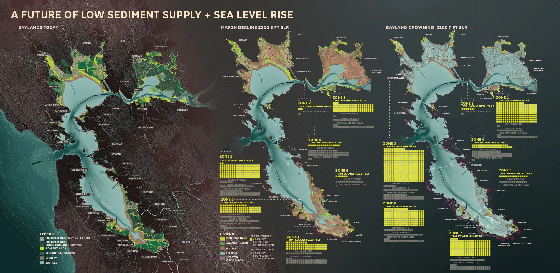
Tidal ecosystems are protective infrastructure that cushion the urban edges of the San Francisco Bay. These systems require sediment to grow vertically in response to sea level rise–without sediment, our baylands will drown. Low sediment supply due to upstream dams and channelization represents a slow but devastating scale of loss that threatens ecosystems, recreational landscapes, and places hundreds of thousands of residents and the region's critical drinking water, energy, and transportation systems at risk.
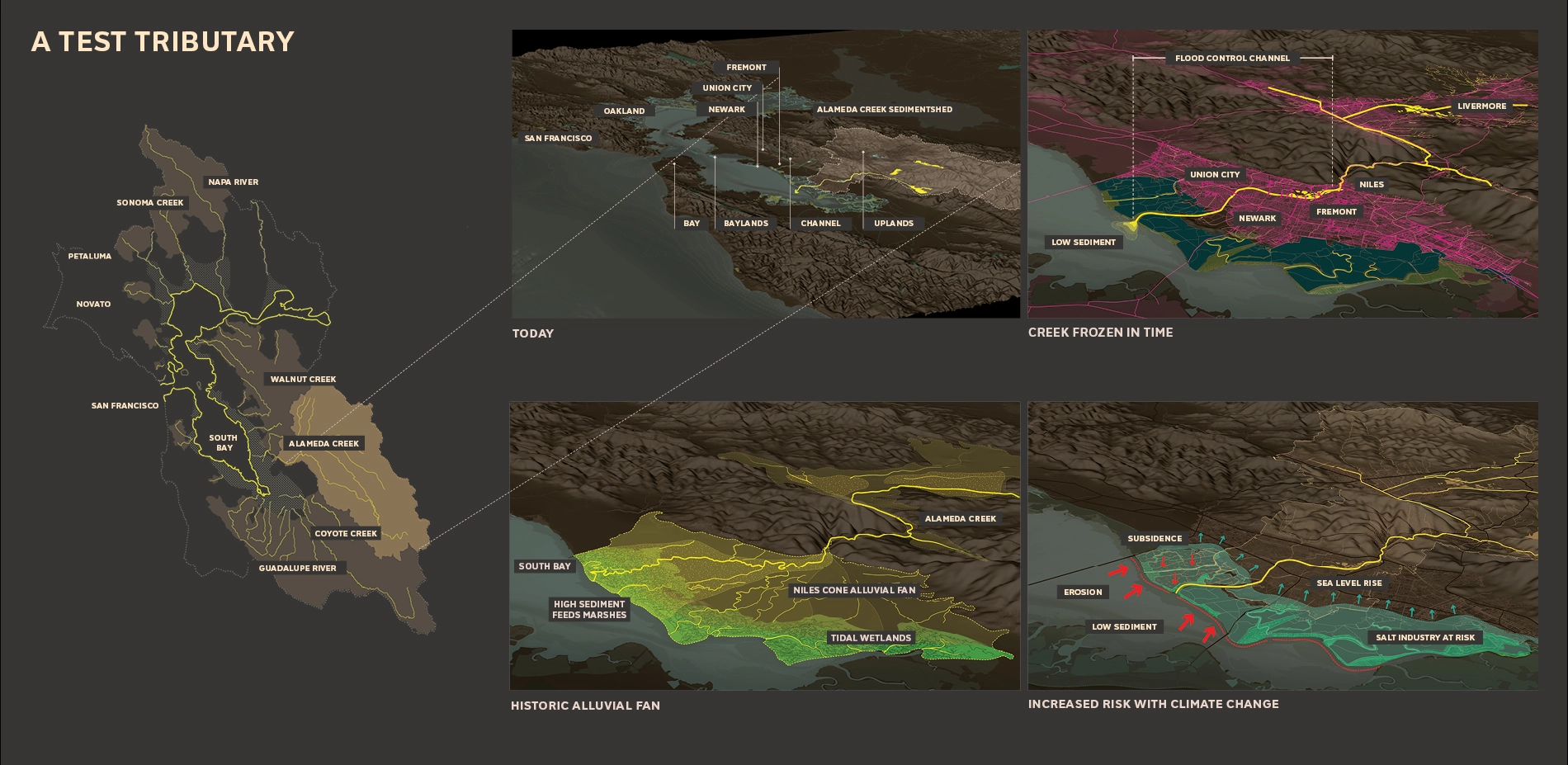
Public Sediment for Alameda Creek is a proposal that addresses the challenge of sediment scarcity along the vulnerable urban edges of Fremont, Union City, and Newark. To bring sediment to the baylands and adapt to sea level rise, our team looks upstream to Alameda Creek, the largest local tributary that feeds the Bay. The proposal aims to redesign this waterbody to create functional systems that sustainably transport sediment for sea level rise adaptation, engage people, and provide habitat for anadromous fish.
UNLOCK ALAMEDA CREEK: THE CREEK
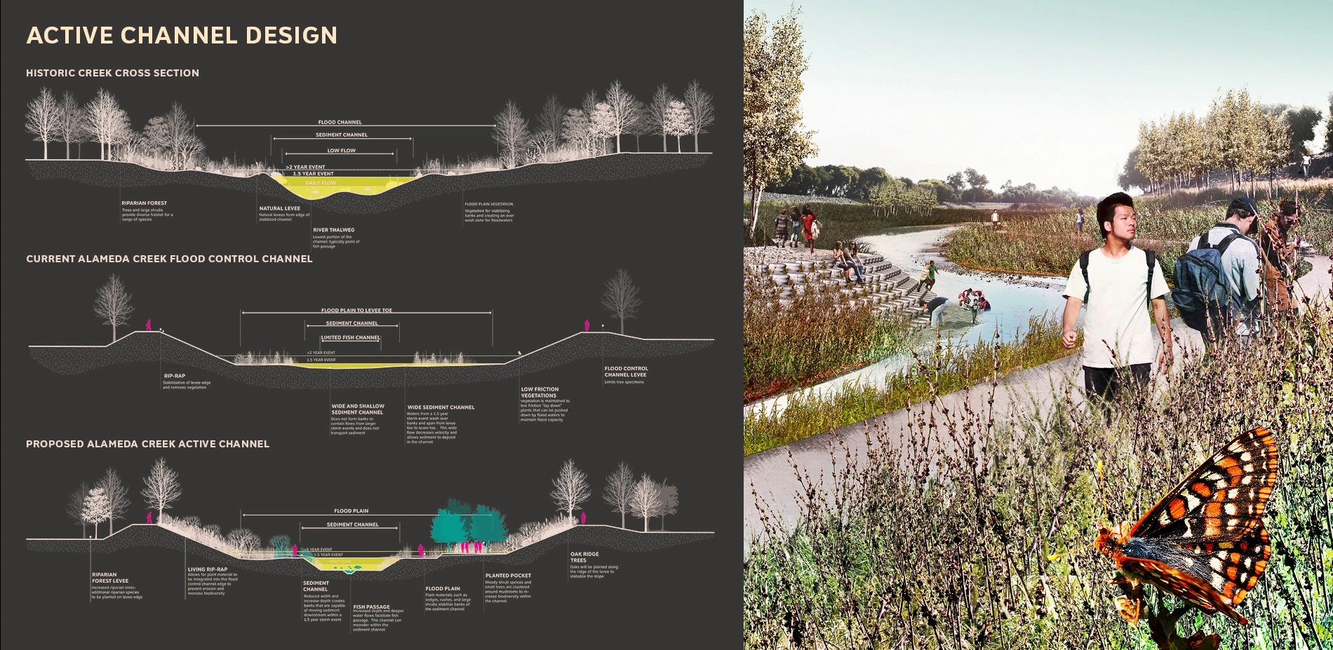
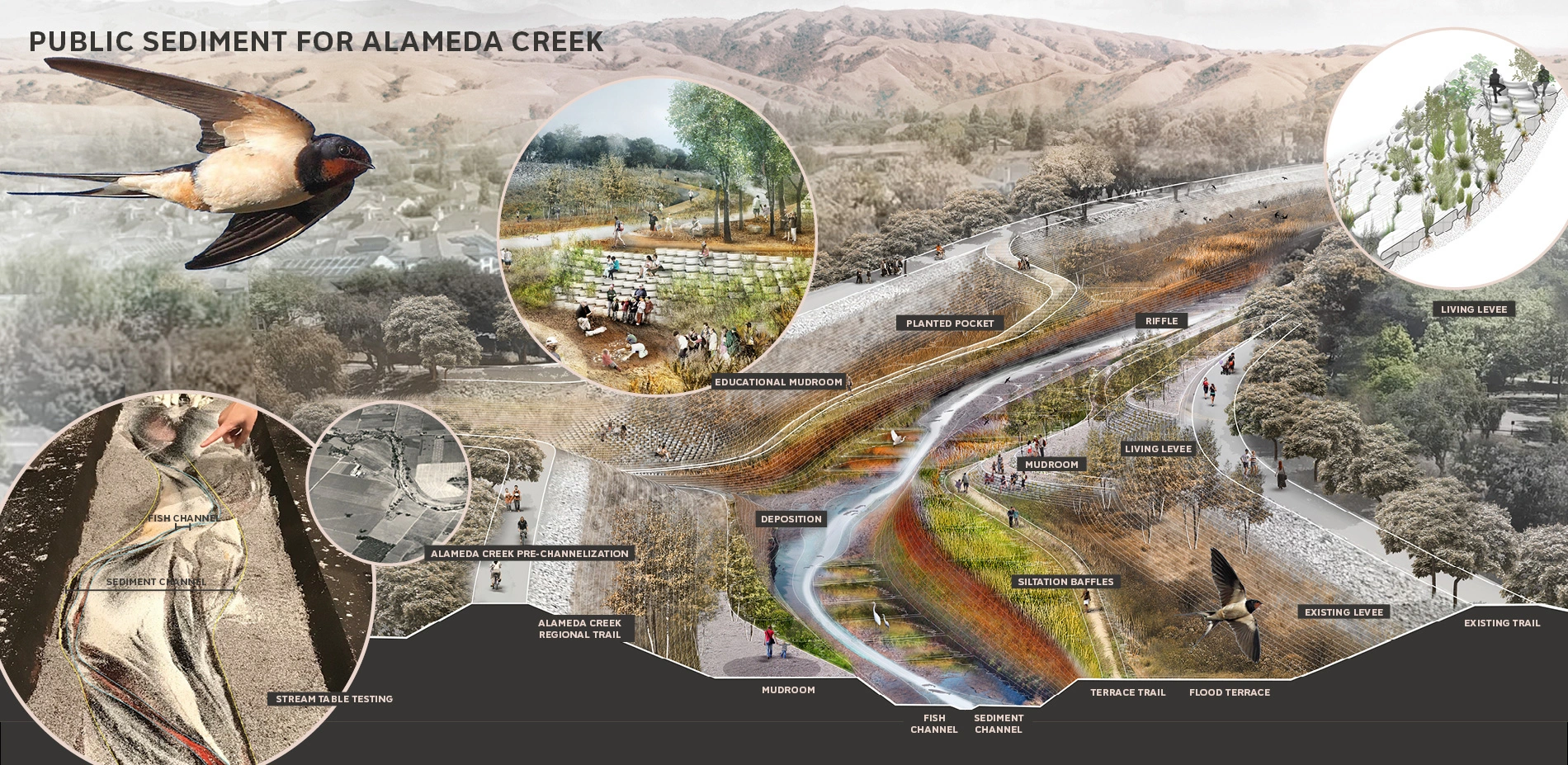
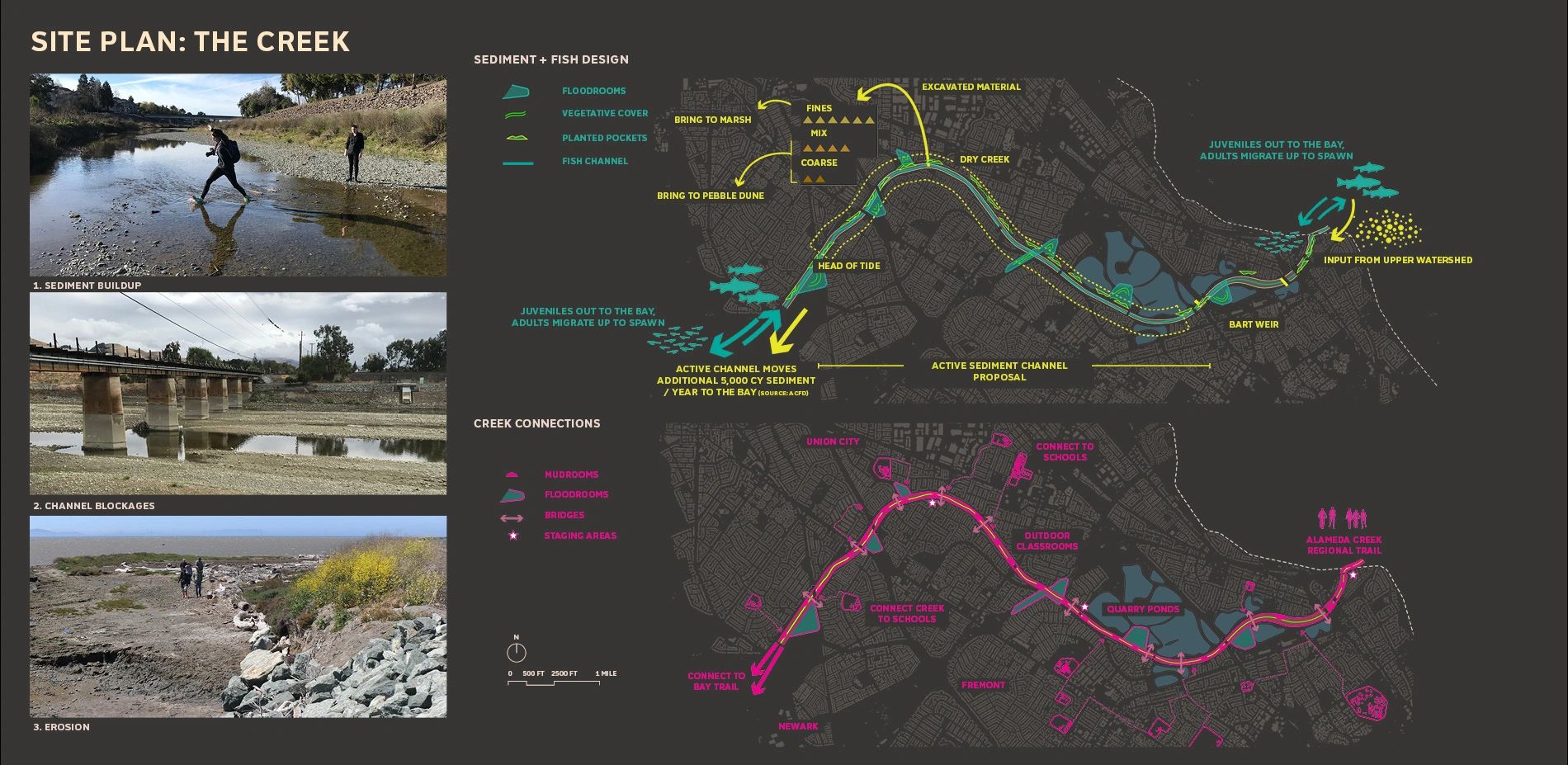
Alameda Creek was channelized to protect the neighborhoods of Fremont, Union City, and Newark from extreme floods. Historically, the creek fed the tidal baylands directly with sediment, nourishing this living infrastructure over time. But now, the channel has sterilized a living system. While the system can never return to its past state, Public Sediment for Alameda Creek proposes to reintroduce sustainable sediment flows, ecological connectivity, and public access back to the creek to address the climate change threats of the future. The project builds on work developed by the Alameda County Flood Control District (low-flow channel), and collaborations between many partners in the watershed around enhanced fish passage including the Alameda Creek Alliance, Alameda County Water District, the Fisheries Restoration Work Group and many others.
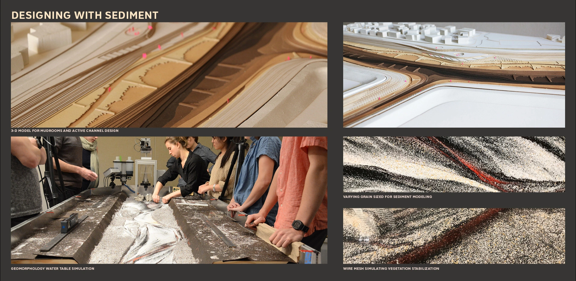
The channel was not designed to move sediment. Today, coarse grain sediment builds up in the channel, reducing flood storage capacity and creating a continual need for dredging. The project proposes to redesign the channel for increased sediment flows, excavating a bankfull sediment channel that moves sediment downstream during annual floods, stabilizing it with vegetation. The new channel is projected to bring an additional 5,000 cubic yards of sediment to the bay annually, creating habitat and introducing moments of public access in and across the creek.
Many species depend on a connected creek for survival. Historically, Alameda Creek hosted some of the largest runs of steelhead trout in the region. Today's these runs are all but lost due to channelization and barriers to passage. Plans are underway to add fish ladders to major infrastructure crossing, but even with these improvements, the wide and shallow cross section of Alameda Creek inhibits the successful migration of steelhead. The project proposes to construct a deeper fish channel that creates deeper flows for fish passage and introduces more diverse vegetation in the channel. Floodrooms expand critical foraging and refuge areas, for steelhead and a wide variety of floodplain-dependent species.
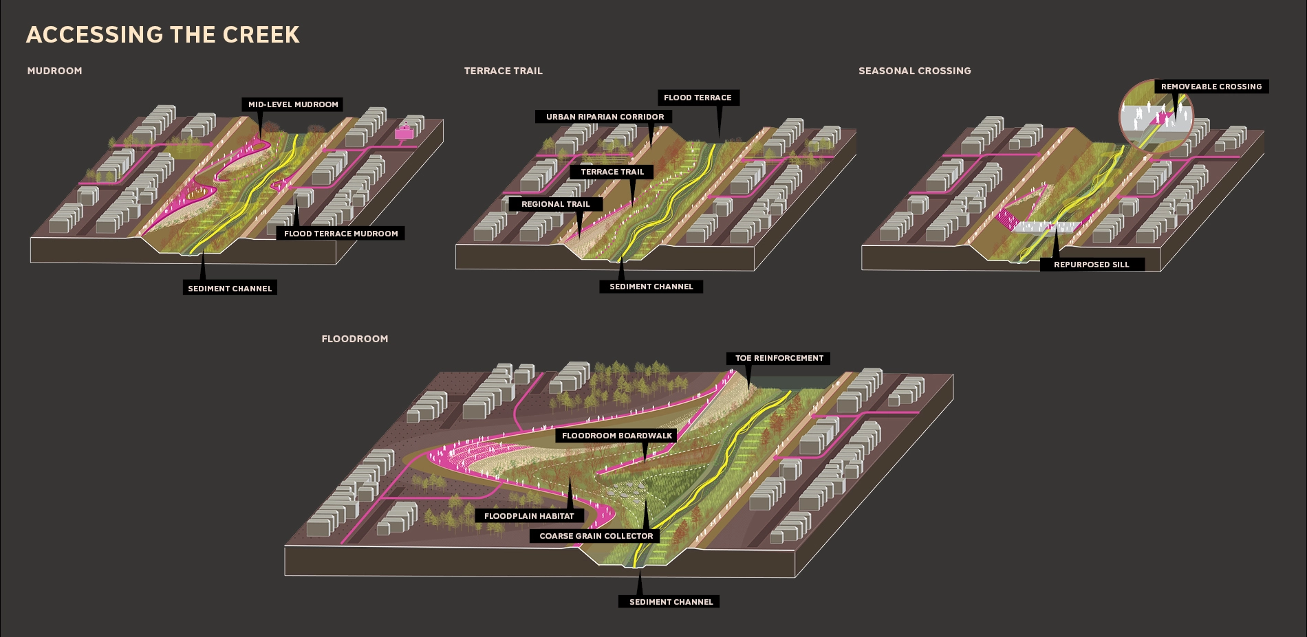
The channel and its levee infrastructure also impact local communities, separating wealthy, middle income, and disadvantaged communities in the large and diverse suburbs of Fremont, Union City, and Newark. While the levee trails are popular, people are isolated to the upper edge, not able to access the water, cross the creek, or participate in the changing system of the creek. We propose four types of public access: Mudrooms, Floodrooms, Terrace Trails, and Seasonal Bridges. Each can respond to flooding events, with managed access during the winter season.
UNLOCK ALAMEDA CREEK: THE BAYLANDS
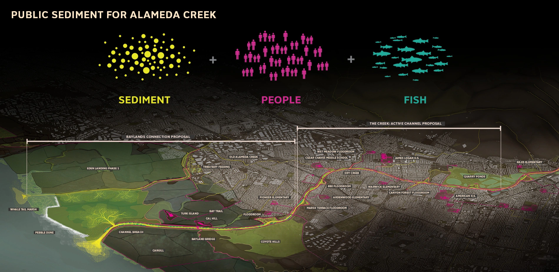
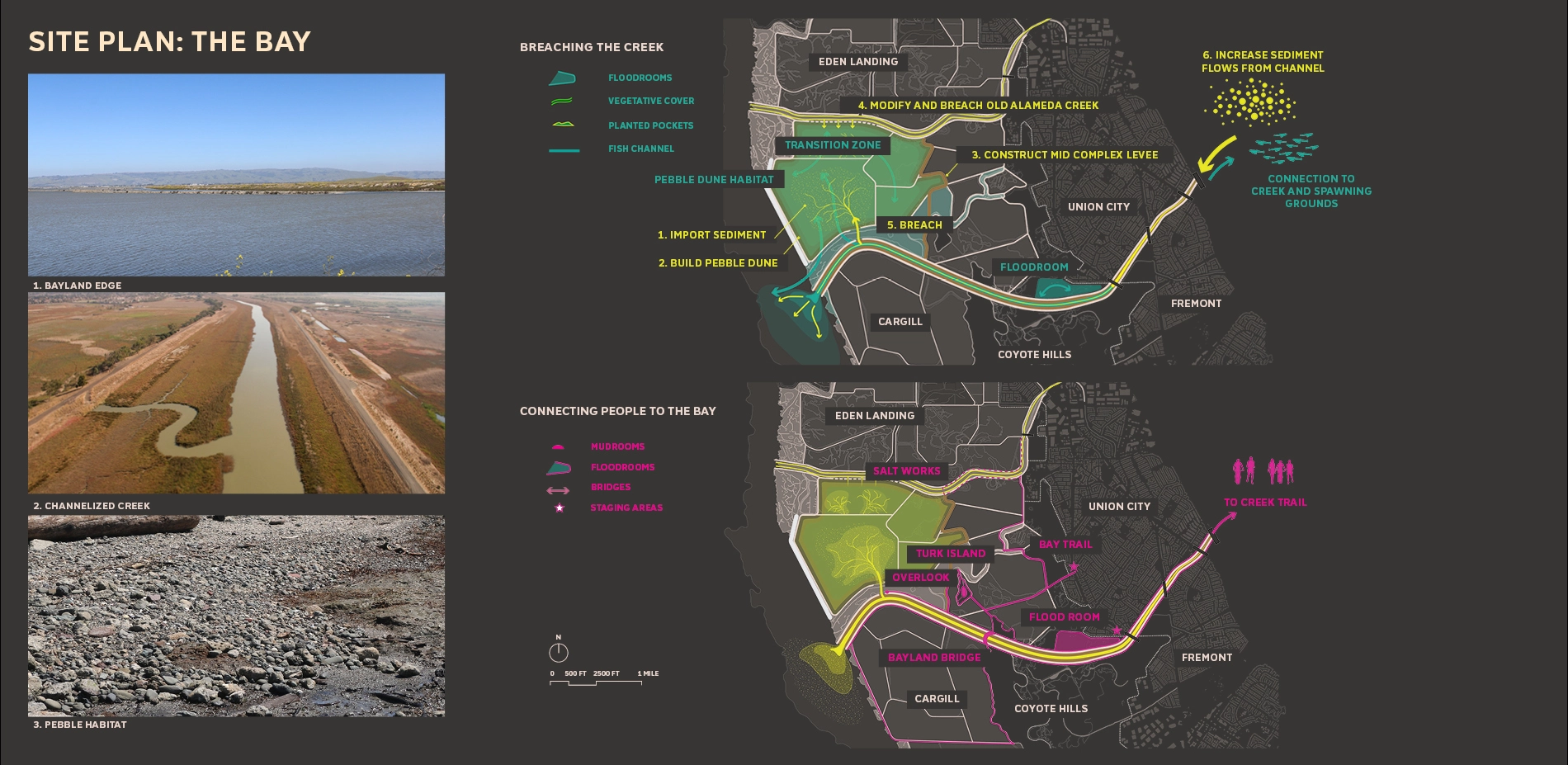
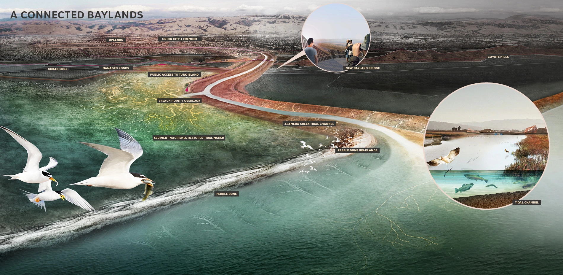
Public Sediment for Alameda Creek proposes to directly connect the sediment flows of the fluvial creek system with the future tidal baylands at Eden Landing. Breaching the creek is critical for long term tidal bayland survival: even in its compromised state, the Alameda Creek watershed moves enough sediment to nourish the restored tidal marshes with moderate rates of sea level rise. Although breaching appears simple, in practice it is a complex choreography of physical and regulatory conditions that balance flood risks, liability, habitat tradeoffs, and public access requirements. The proposal connects the creek to the baylands to balance the needs of people, sediment, and fish at the Bay's edge. The bayland portion of the project builds on work developed by the South Bay Salt Pond Restoration Project at Eden Landing, California Fish and Wildlife, the Alameda County Flood Control District, East Bay Regional Parks, the Bay Trail, and others.
Public Sediment for Alameda Creek proposes a multi-part strategy to connect sediment with the baylands and address short and long-term flood risks. The series of flood risk reduction actions includes the construction of a mid-complex levee to separate managed ponds from tidal ponds, and the construction of a perimeter "Pebble Dune" that mimics a barrier island, reducing tidal forces and protecting the baylands from wave action and erosion. With these interventions in place the creek can be breached, sediment can enter the baylands, and a new wetland cushion can be nourished over time.
The channelization of the creek has severely limited an estuarine mixing zone, transforming what was historically a wide marsh plain of shallow meandering sloughs into a single linear channel. The breach reintroduces this mixing zone, creating space for a range of species like juvenile steelhead, which require this transitional space to adapt to a salt water environment.
The proposal also includes a series of new destinations in the baylands, including an extension of the bay trail and a Breach Bridge that jumps the channel and moves with the tides, linking the greater path network of Eden Landing and providing a clear overlook to the newly forming delta.
COMMUNITY ENGAGEMENT + SENSING
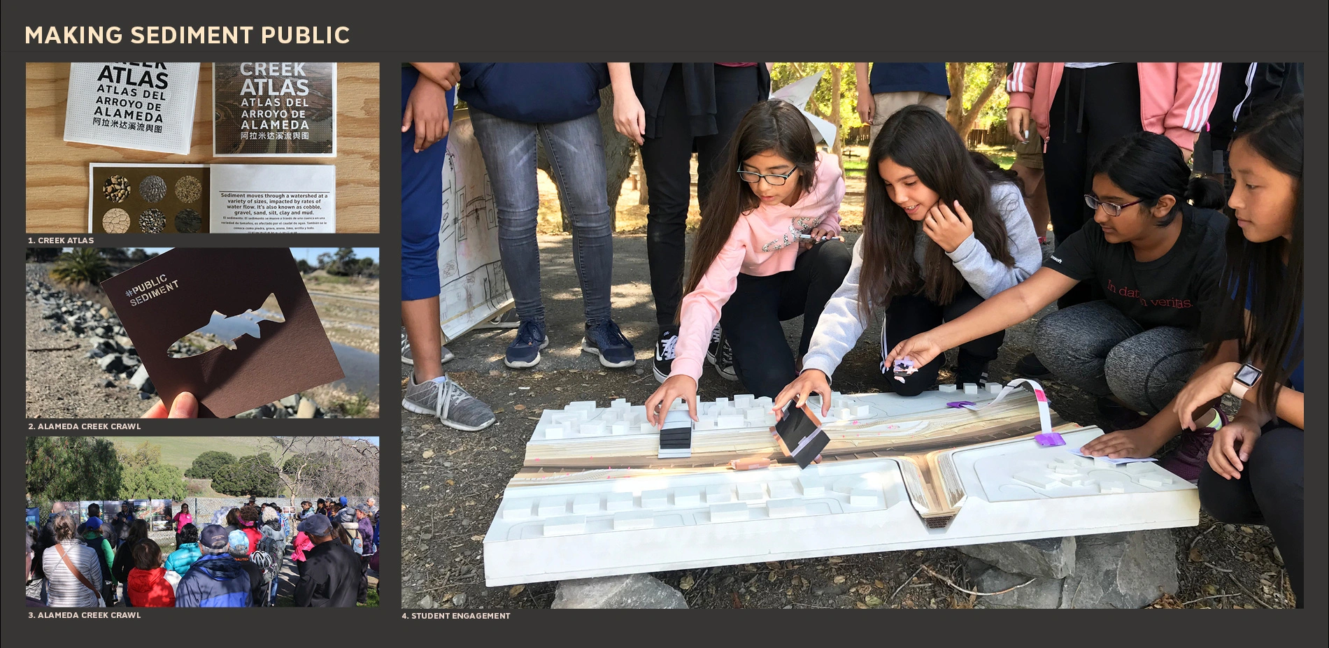
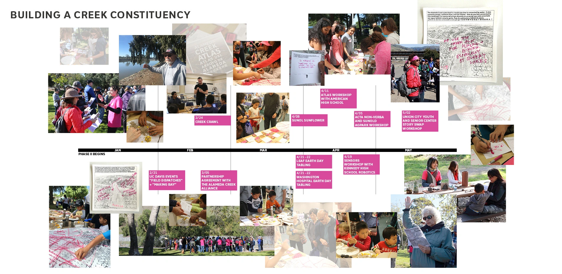
The transformation of Alameda Creek from creek to flood control channel has erased its public identity as a landscape resource. The project team has been holding events in and around the Creek to understand how people perceive this space today, how they remember it, and how they want to use it. The Creek Atlas synthesizes these narratives and reflects on changing attitudes towards Alameda Creek, suggesting new futures for the ecosystem while engaging students, youth, and residents in this dynamic environment. The Alameda Creek Crawl invited over 100 residents and community stakeholders to look past the flood control channel and experience the living creek hidden in their backyards. With these efforts, the team aims to build a stronger constituency for the creek and develop awareness and activism around resources for the future.
Public Sediment for Alameda Creek was developed for the Resilient by Design Initiative, an effort to raise awareness and develop implementable solutions for sea level rise adaptation in the Bay Area. After the completion of the design phase of this project in 2018, the project is funded for pilot design of the Pebble Dune system by the NOAA/NFWF Coastal Adaptation Grants and continues into 2019 as an active initiative.
BAY SCALE
Public Sediment for Alameda Creek is just a test. Looking beyond the single tributary, the techniques and partnerships piloted in Alameda creek can serve as precedent for bay-wide action. Over the next decade, the Public Sediment methodology and ethos must be applied to other tributaries, particularly tributaries that contribute large volumes of sediment to the bay today, tributaries with large volumes of sediment trapped upstream, or tributaries with the most potential or need for tidal baylands cushions at their mouth. An adaptive sediment management strategy must be developed for the region that balances the sediment inputs to the bay with local tributary inputs, sea level rise rates, and tidal bayland restoration and coastal protection goals. Public Sediment for Alameda Creek represents a small step towards a paradigm shift in how we plan for climate change.
-
- SCAPE (Landscape Architect)
- SCAPE (Lead Designer)
- Dredge Research Collaborative (Sediment Design)
- Arcadis (Coastal Engineering)
- Uc Davis Dept. of Human Ecology and Design (Participatory Design)
- TS Studio (Landscape Architecture)
- Architectural Ecologies Lab (Ecological Design)
- Cy Keener + Justine Holzman (Monitoring)
- Alameda County Flood Control and Water Conservation District
- South Bay Salt Pond Restoration Project
- East Bay Regional Park District
- State Coastal Conservancy
- Alameda Creek Alliance
- San Francisco Estuary Institute
-
Product Sources: N/A
Advertisement
Related Awards

Honor Award, Analysis & Planning
A Cultural Approach: The Fort Peck Tribes Hazard Mitigation Plan
In collaboration with the Fort Peck Assiniboine and Sioux Tribes, EPA, and FEMA, the Fort Peck Tribes Hazard Mitigation Plan (HMP) adopts a culturally responsive approach to hazard mitigation planning that features connection to place.


Related Articles

Landscape Architecture Magazine
LAM Wins Five ASBPE Awards
Landscape Architecture Magazine earned national and regional honors for editorial excellence, publication design, and profile.
Jun 1 2026