
.webp?language=en-US)


Terre d'eau - Land of Water
Marianne Lafontaine-Chicha, Student ASLA
Boldly attacks a timely issue of broad relevance.
Awards Jury
-
The St. Lawrence-Great Lakes navigation channel acts as a spine for Canada's economic exchanges. With alarming climate scenarios in which a significant decrease in water levels is projected, authorities will require a new capital dredging project.
This project focuses on the dredging of the Lake St. Pierre, a UNESCO biosphere reserve traversed by a major navigation channel. The massive removal and necessary placement of dredge material presents a unique opportunity to design with dredge according to the principles of socioeconomic development as well as biological and cultural diversity specific the UNESCO designation.
In an effort to de-abstract the navigation channel, Terre D'eau designs across the waterway, below and above the waterline, as a way to create a purposeful encounter between the adjoining land and surrounding water to strengthen the embedded sociocultural and capital relationships, and benefit struggling ecosystems.
-
BACKGROUND
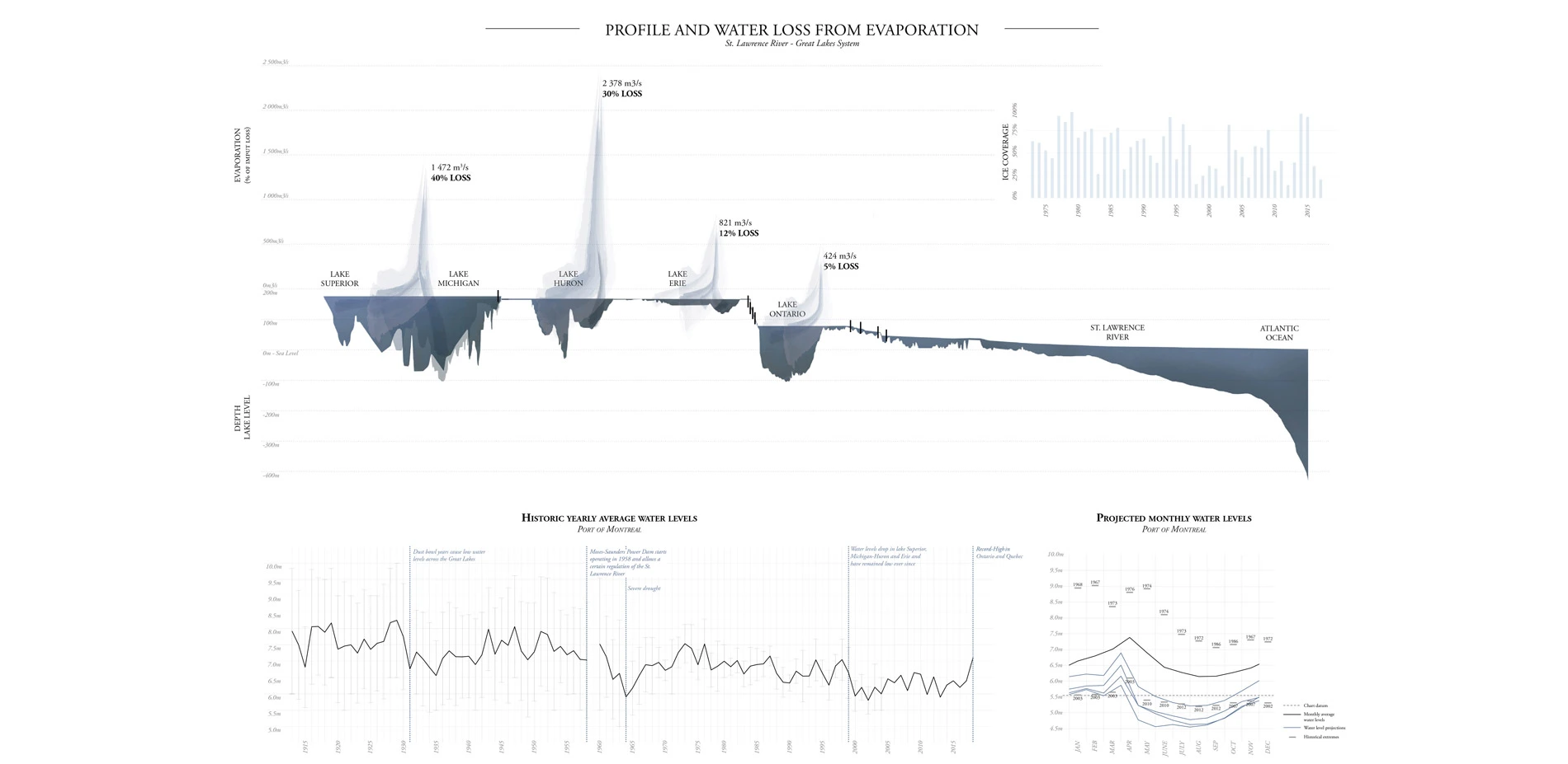
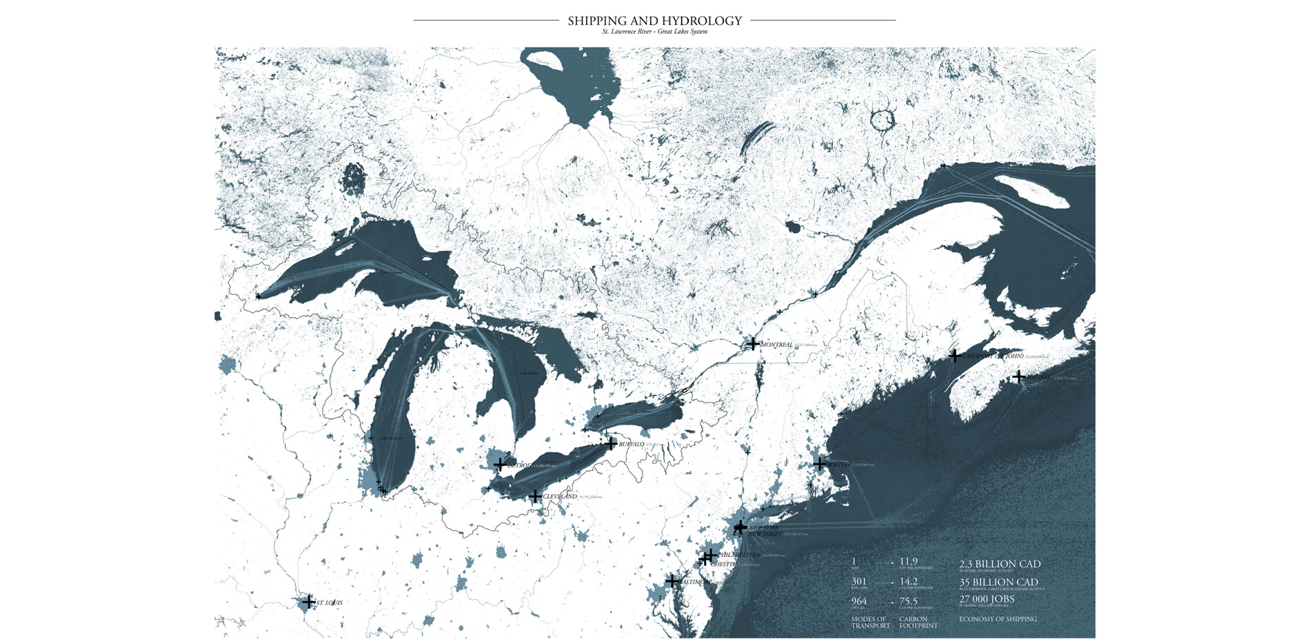
With 97% of Canada's international exports made through seaborne trade, oceanic shipping is at the very core of Canada's economy. Given its numerous geographic, economic and logistical advantages, the port of Montreal is situated at a pivotal point along the St. Lawrence-Great Lakes route. While it acts as an oceanic port, it is actually situated 1600km inland along the St. Lawrence River, an incredibly rich and diverse ecosystem. The River might be a crucial infrastructure, but it is subject to the same climatic uncertainties as the rest of the world. Numerous scenarios relating to evaporation rates within the Great Lakes-St. Lawrence River Basin indicate that water levels will significantly decrease in the coming years, impacting the datum level of the river, and the ships' authorized capacity.
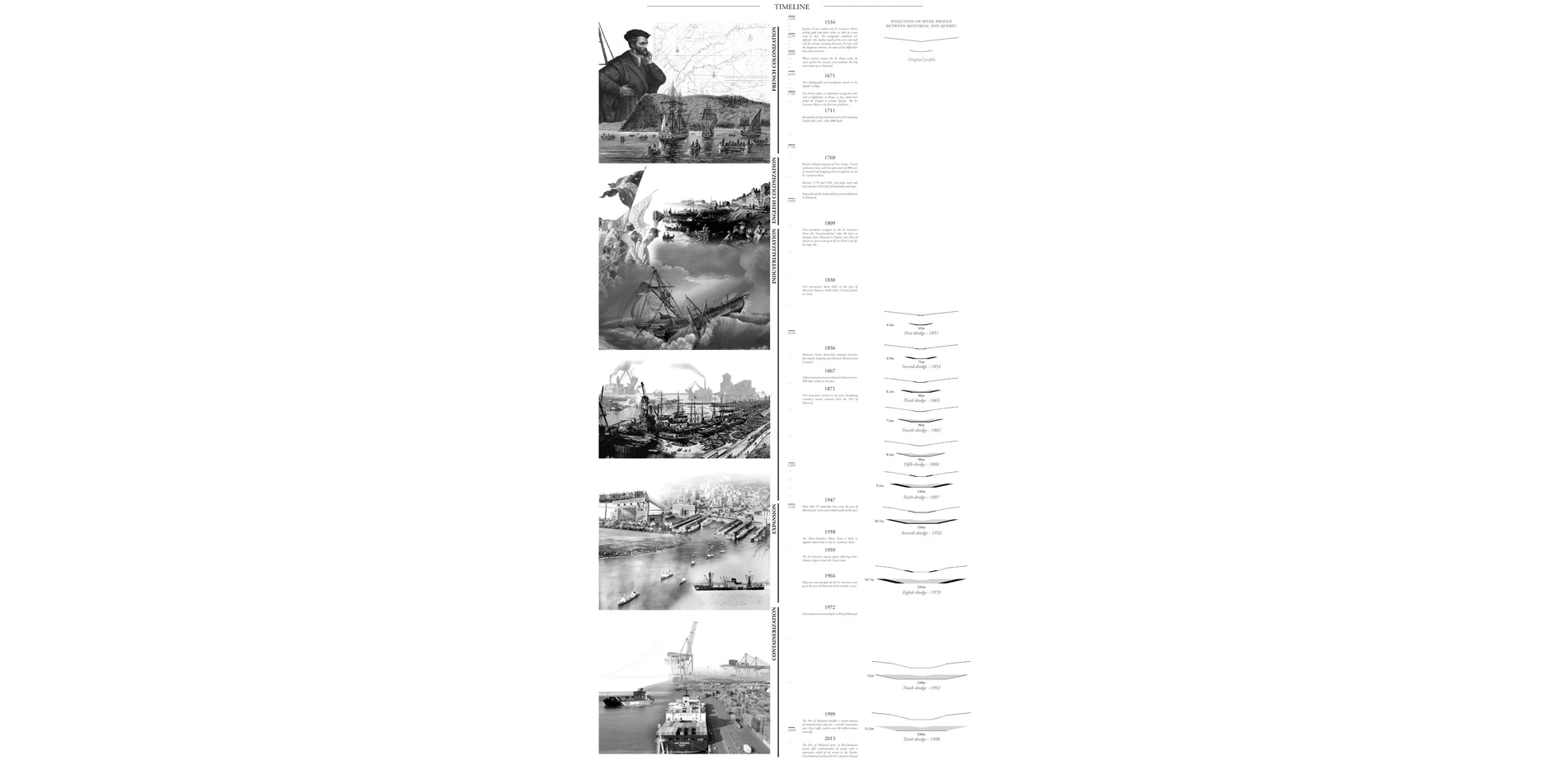
As such, a new capital dredging project will have to be considered in the coming years. The St. Lawrence has been a major shipping route since the 16th century and was dredged for the first time in 1851. A total of nine more dredging projects have occurred since then, drastically modifying the profile of the river and its hydrodynamics. The channelization, damming and dredging of the river have all been in support to the shipping industry, with minimal consideration for the impact on the ecosystems and limited reuse of the dredge material.
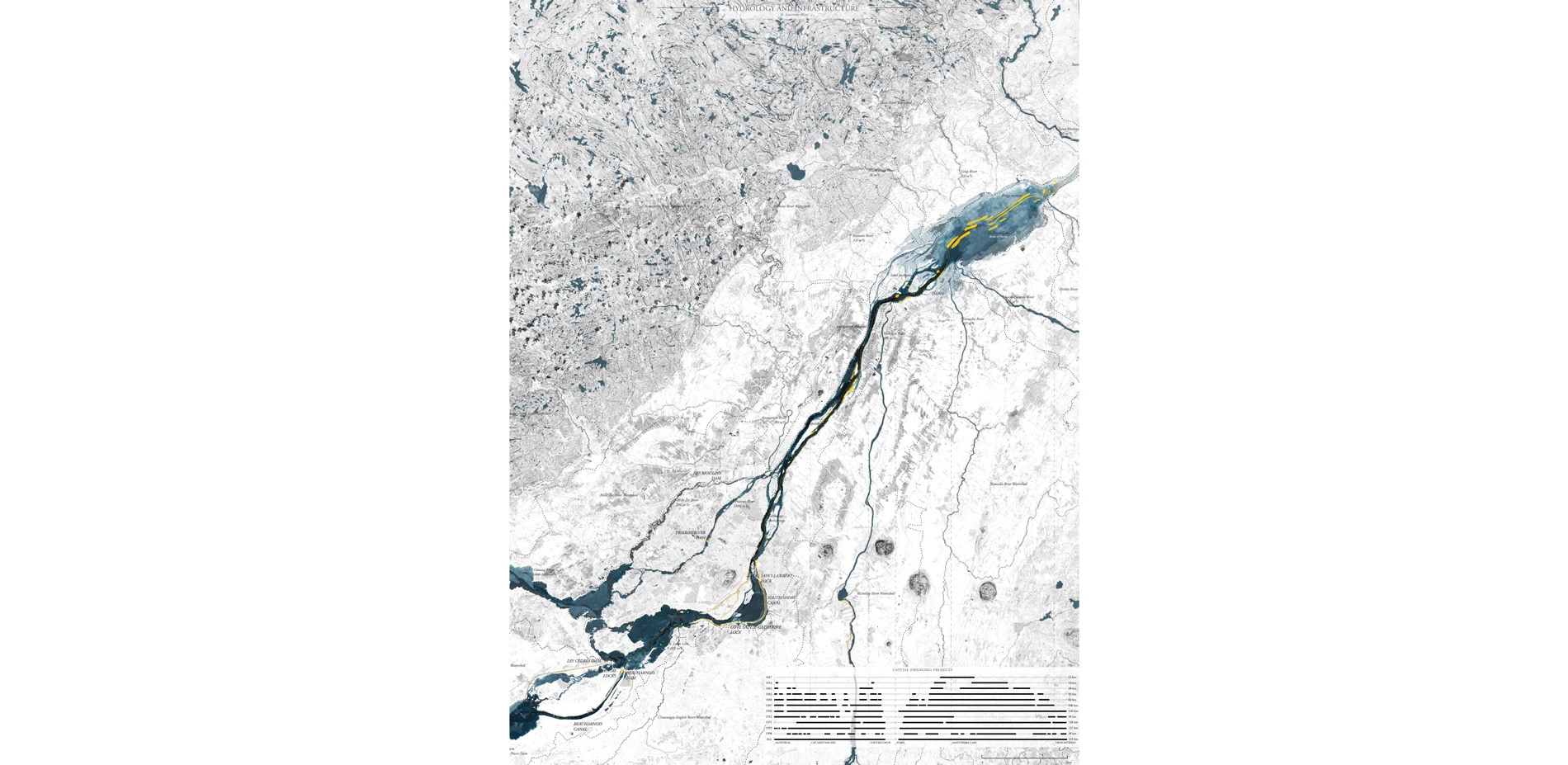
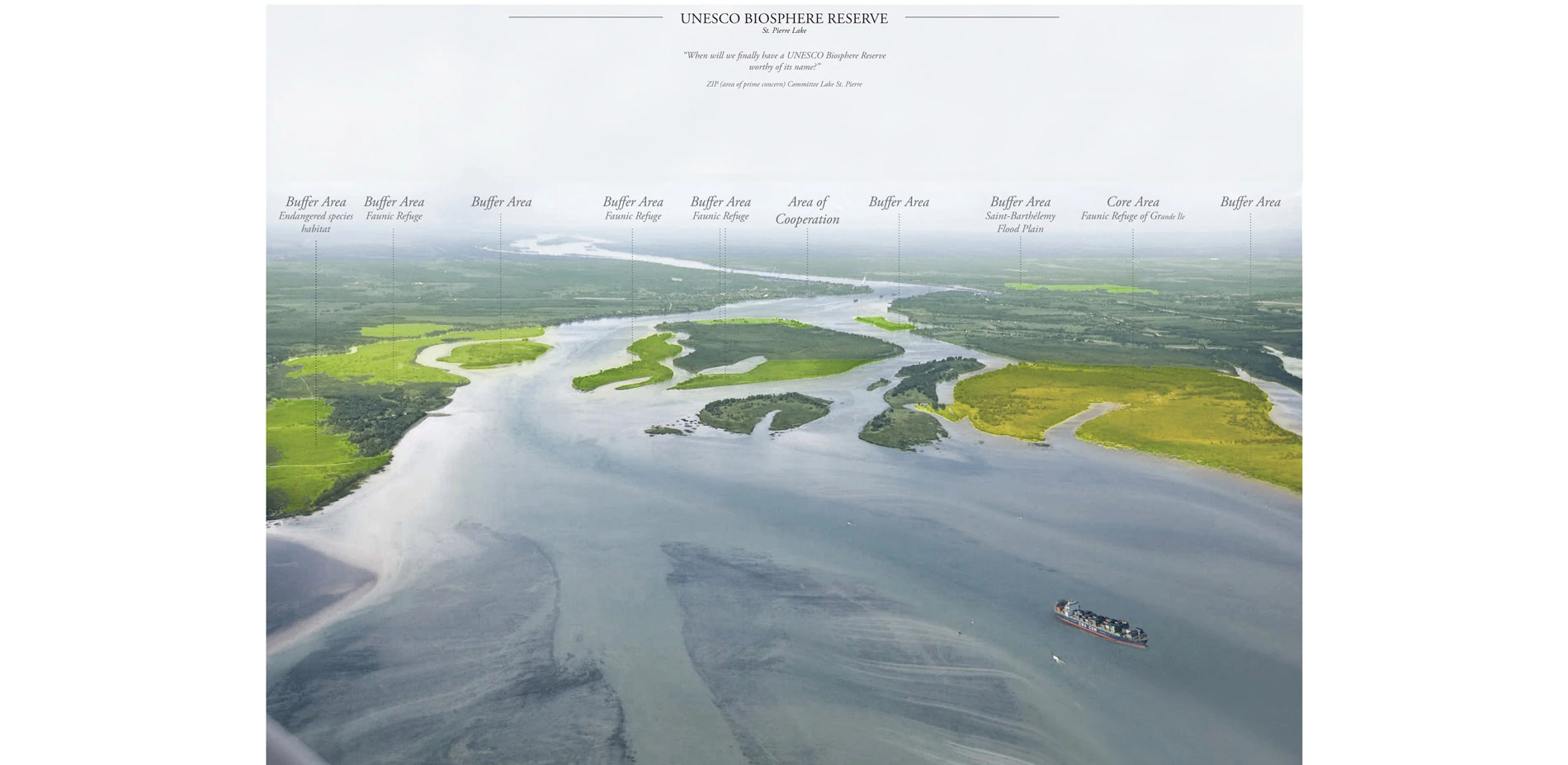
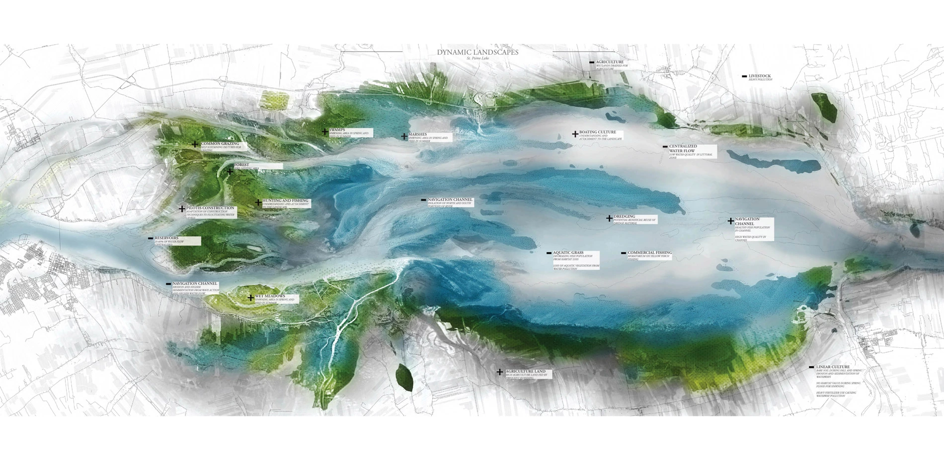
The Lake St. Pierre, a fluvial lake within the St. Lawrence River, was used as a test site for this project. Its UNESCO biosphere designation makes it the perfect site to investigate and reconsider the relationship between a navigation channel and the adjoining landscape.
ISSUES
The physical manipulations of this landscape have led to a number of issues.
Water flow and eutrophication
The water flow has been channelized to the center of the navigation by cutting off secondary channels with dams. This has caused the water from the Great Lakes to remain within the navigation channel, leaving the shoreline and secondary channels exposed to highly polluted water from the tributaries, surrounded by agriculture land. As the dams slow the water flow, the water spends extensive time in the system, causing heavy sedimentation and eutrophication within the lake.
Erosion
It is estimated that more than 40% of the shorelines between Montreal and the Sorel Archipelago are eroded. The erosion of shores less than 305m away from the navigation channel is a direct consequence of the increased water flow and wave action within the channel due to ship passage. In average between 1,5m and 5m of land are lost to erosion every year causing disturbance to ecologies as well as human settlements along the river. This also causes high sedimentation in the areas of lower water flow, which often correspond to wetlands.
Drought and loss of biological diversity
With projected lowering water levels across the Great Lakes and the St. Lawrence River, ecologically sensitive areas dependant on a certain exposure to water will be in danger. These are the perfect conditions for invasive species to take over, and if nothing is done, within fifty years this landscape will become a sea of phragmites with a navigation channel at its center. As this area contains 40% of the wetlands of the St. Lawrence River and is the largest heron-nesting site in North America, this would be a tragedy.
The economy of this area and the strong local attachment is dependant on a thriving landscape. As such, all of these issues are what led the people of the ZIP Committee Lake St. Pierre to ask "When will we finally have a UNESCO biosphere reserve worthy of its name?"
DESIGN INTENT
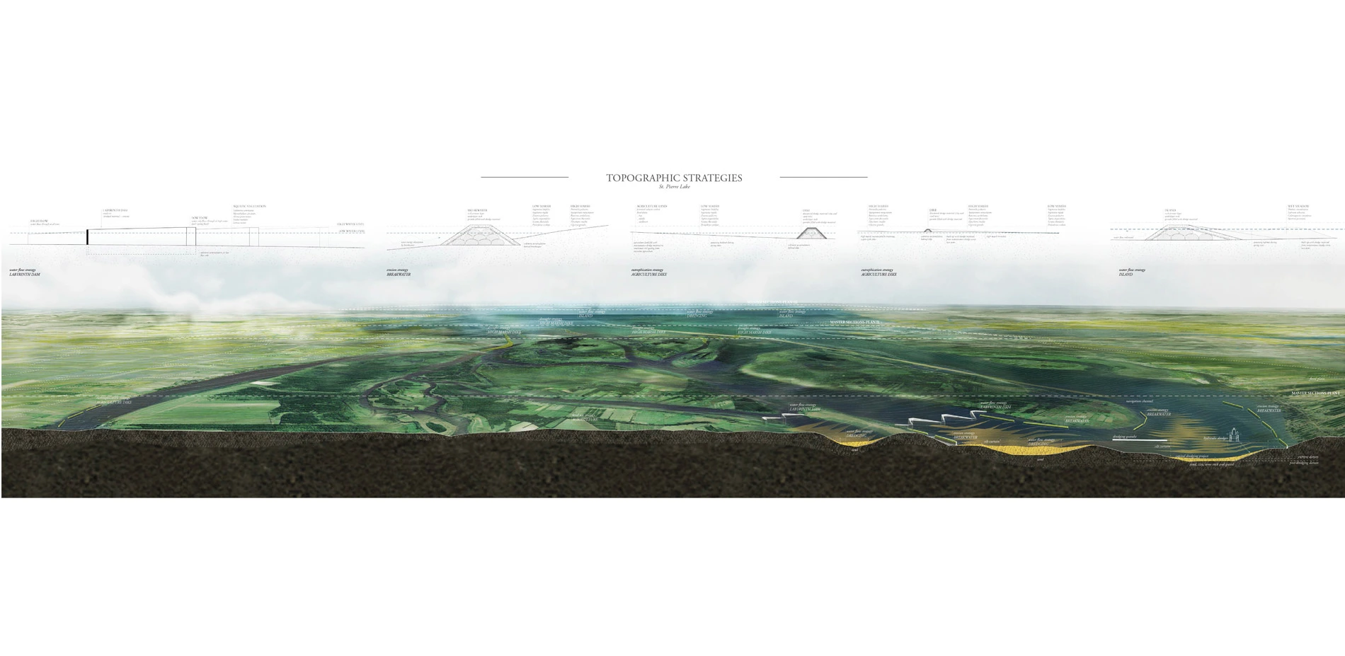
In an effort to de-abstract the navigation channel, transects are used as a way to create a purposeful relationship between the channel, adjoining land and surrounding water. The design strategies take place below and above the waterline, taking advantage of the seasonal flux in water levels to direct and retain water where desired. Rather than being considered as a waste product, dredge material is the main resource for this project, affording it a strong sense of locality. While the capital dredging project is the principal source of material, the maintenance dredge allows for a biennial influx of material to respond to evolving conditions and build up the original topographic interventions.
DESIGN STRATEGIES
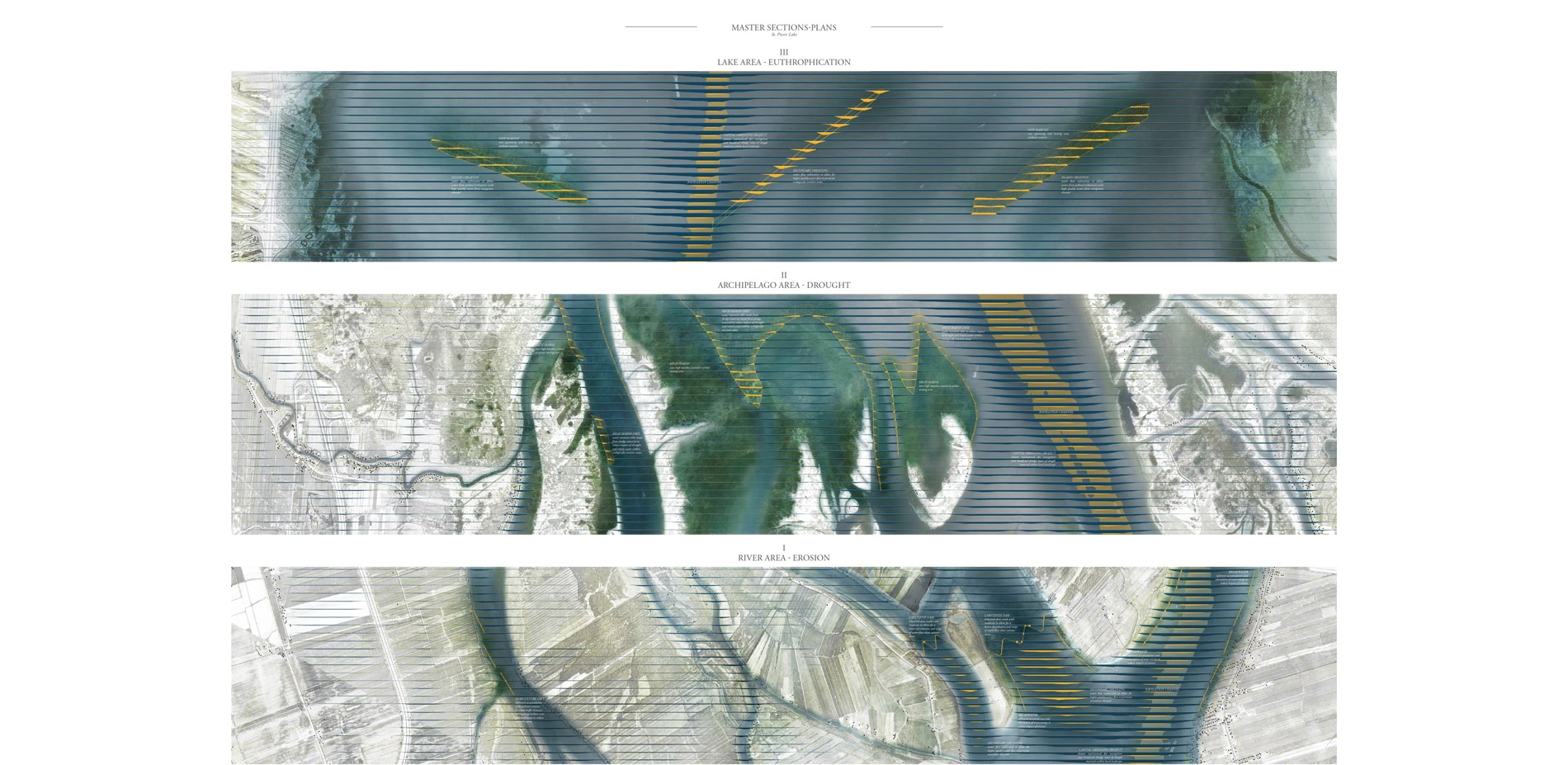
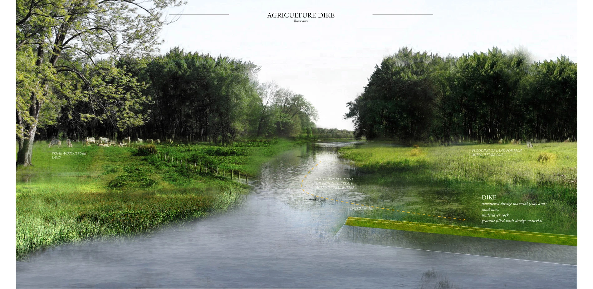
Transect I – River area
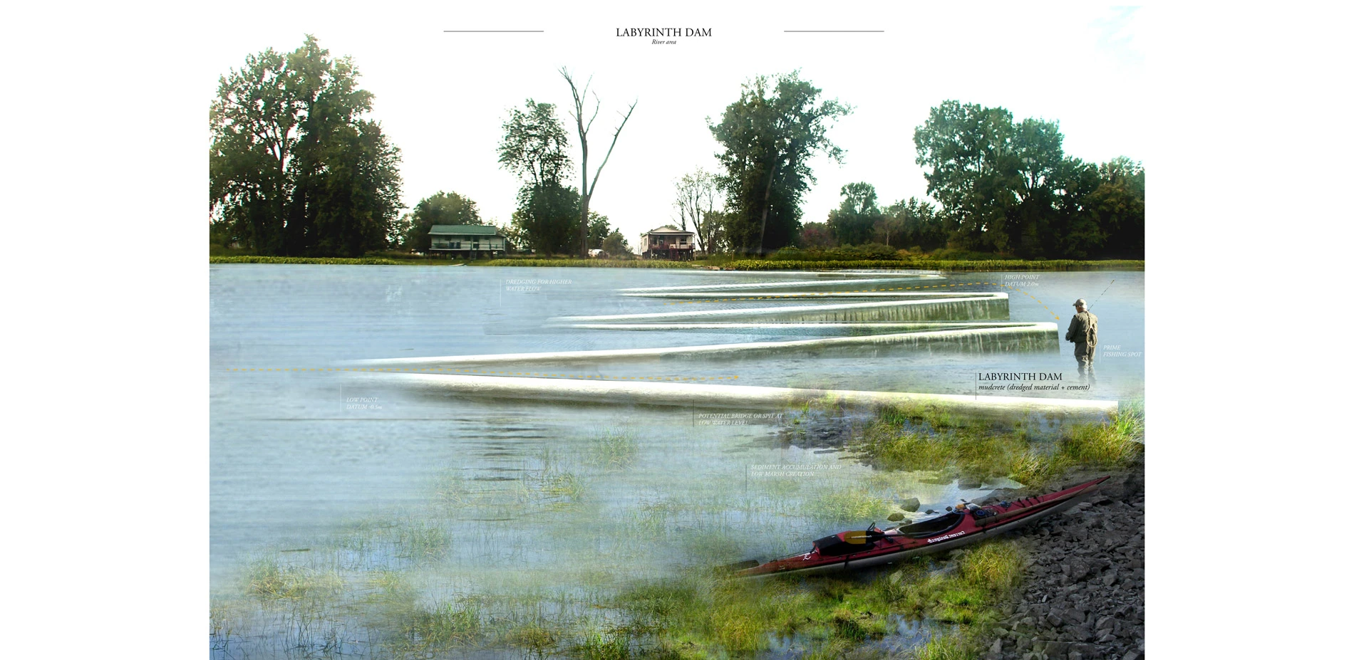
Erosion and water flowA number of strategies are used as a way to redistribute the water flow and reduce erosion. On top of the capital dredging of the navigation channel, supplementary dredging is proposed as a way to allow water from the Great Lakes to permeate within this landscape and augment the water flow. Furthermore, labyrinth dams are proposed, which allow a better distribution and range of water flow than the current dams do. Breakwaters are also added in as a way to reduce erosion and start collecting sediment behind them. Finally, dikes are created as a way to buffer the agriculture land collecting sediment.
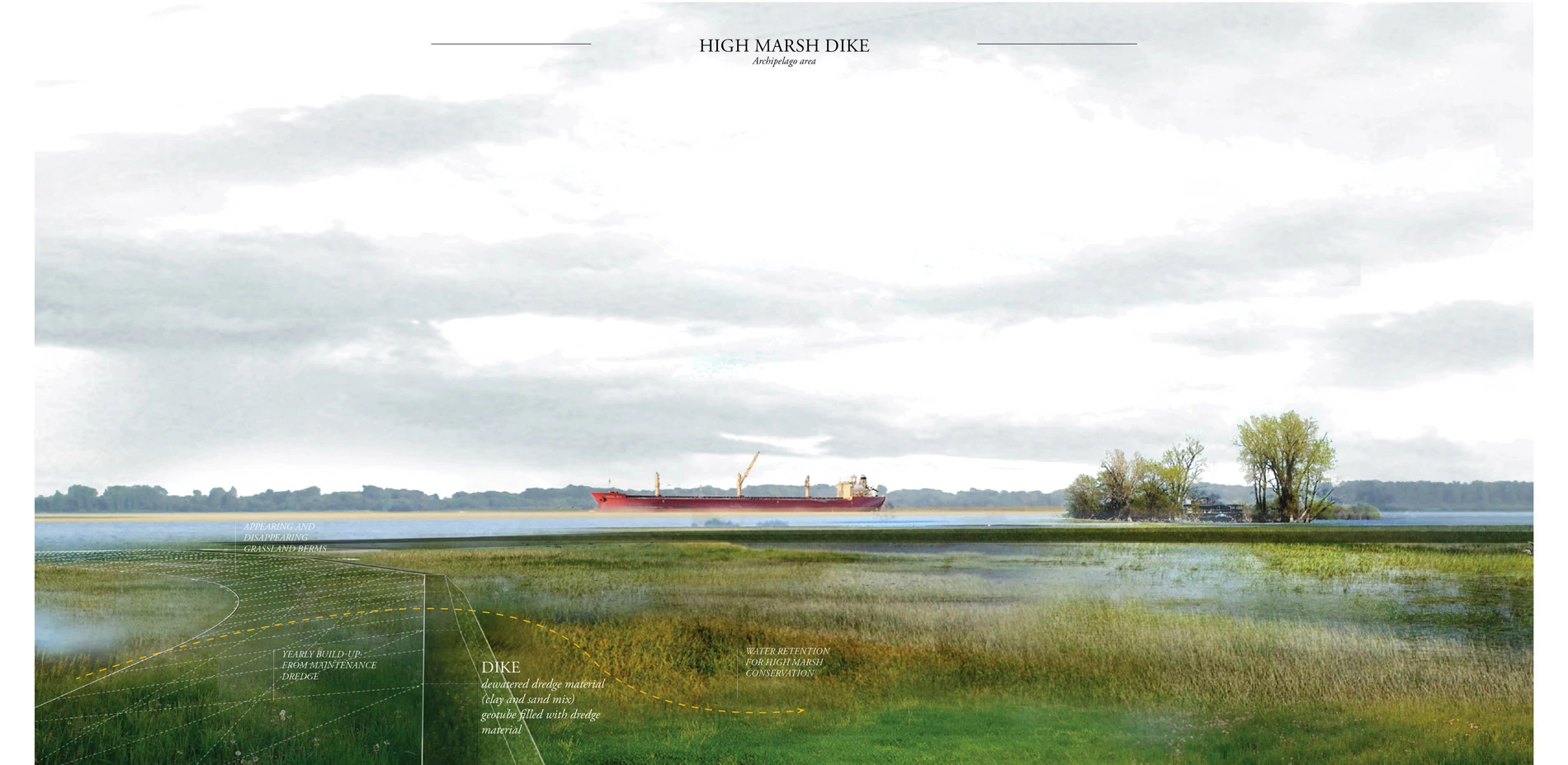
Transect II – Archipelago area
Drought conditionsThis area focuses on the retention of water in wetland areas subject to drought. These interventions specifically target high marshes, as they are the most at risk. They are also meant to collect sediment on their backside, building up more marsh area over time. These are calibrated according to water levels in a dry year. They allow water to flood them during springtime, and then retain water for an extended period of time during the summer months. While their core is built with dredge from the capital dredging project, these are augmented every second year with dredge from the recurrent maintenance dredging operations.
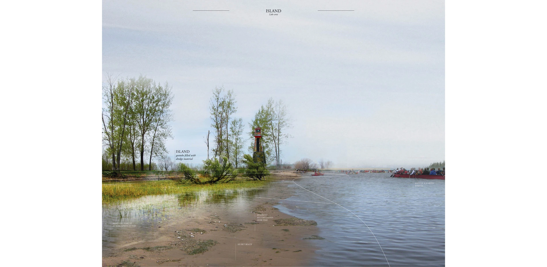
Transect III – Lake area
EutrophicationThis area focuses on diverting water flows. The interventions are built perpendicular to the flow, and are located to buffer the distinct flows from the different tributaries. By acting as an obstacle to these, they will allow water of higher quality and flow to permeate areas where there is currently very little water flow. In addition, dredging perpendicular to the navigation channel is done as a way to also modify water currents.
CULTURAL NARRATIVE
Islands of water, sand and silt, flats and ice, no one can really say how many islands are part of the archipelago. Some say 43, some 112; trying to discover new islands has become somewhat of a local mystery and source of excitement and discovery of this landscape. As such, as the water level fluctuates, the topographic manipulations of this project are revealed to the kayakist or the fisher at different times of the year. At moments when the water is low enough, the weir may become a bridge, or the island may become a secret beach for boat parties. Flat areas are suddenly punctuated by berms and what used to be an isolated lighthouse suddenly becomes a new island.
Named "Land of water", this project is about a landscape that is shaped, fed and revealed by water. Through the movement of land shaped by water for hundreds of year, we rework the water flows of this landscape, allowing it to thrive. There is a sense of place and locality afforded by the focus of this project. By putting the emphasis on dredge material, we are instantly connected to the materiality of this landscape. While navigation channel are seen a static infrastructure regulated by datum and international standards, this project sheds a new light on a system that is actually subject to a lot of flux. This allows for large-scale projects, with issues linked to globalism to be translated to small-scale interventions that have a significant economical, ecological and social potential.
Advertisement
Related Awards

Honor Award, Analysis & Planning
A Cultural Approach: The Fort Peck Tribes Hazard Mitigation Plan
In collaboration with the Fort Peck Assiniboine and Sioux Tribes, EPA, and FEMA, the Fort Peck Tribes Hazard Mitigation Plan (HMP) adopts a culturally responsive approach to hazard mitigation planning that features connection to place.

