
.webp?language=en-US)


Topographic Urban Expansion - A Landscape Armature on Hillsides of Mexico City
Qiwei Song, Student ASLA

Knowing that development would continue to occur on these steep slopes, this project addressed questions of drainage and soil erosion.
Awards Jury
-
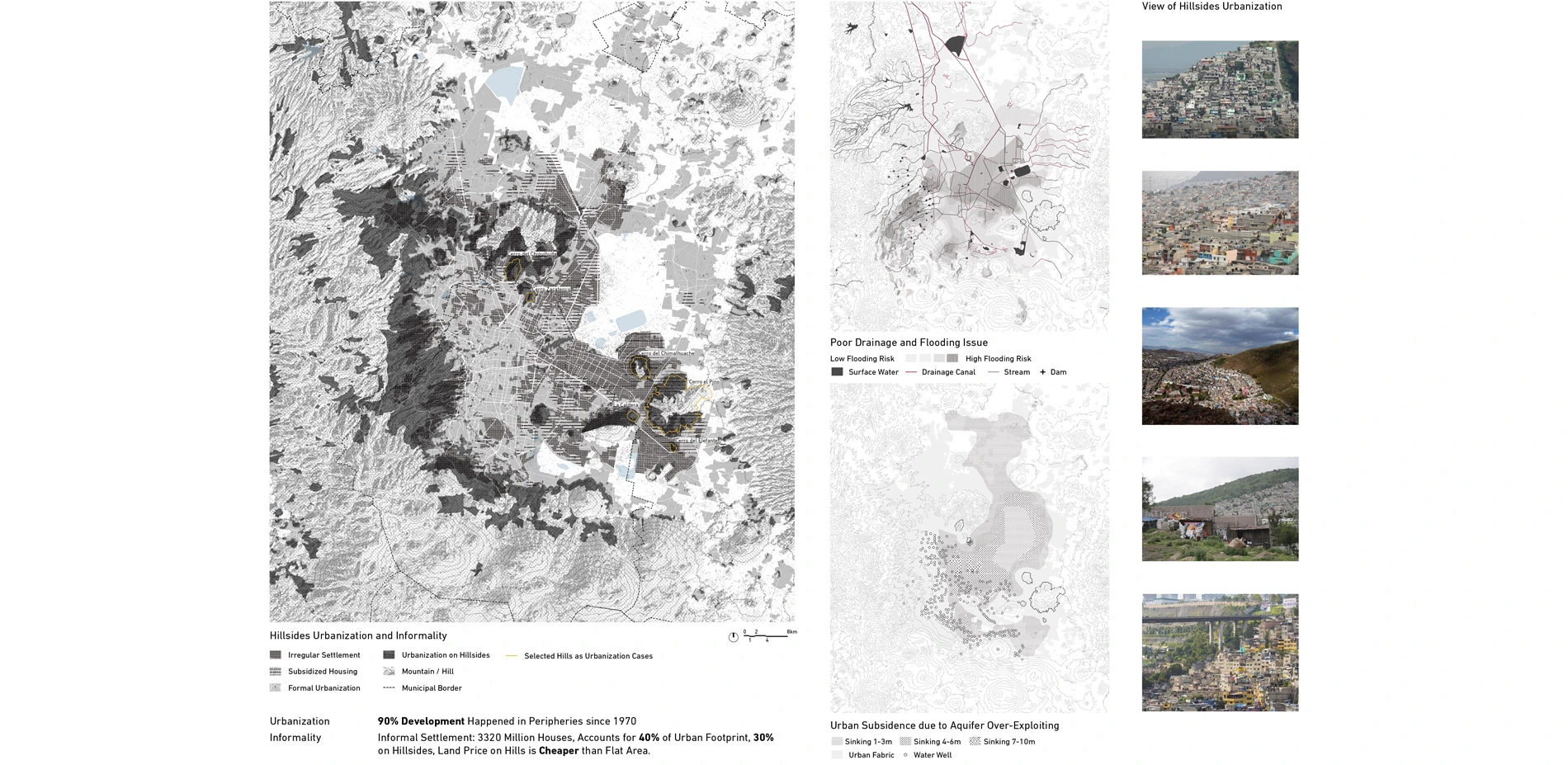
As Mexico City continues to add its population, geologic, economic, social, and historical factors and constraints have pushed development and irregular settlements to the hillsides of the city's peripheries.
Current informal urbanization pattern lacks infrastructural provisions and open space, which further increases social inequality. This project introduces a pre-emptive approach, a topographic landscape strategy that acts as an open space armature for future development on the hillsides of Mexico City. By connecting and planting hydraulic buffers along steep slopes and introducing topographic interventions in connected bands of open space, the project proposes social, ecological, economic, and cultural amenities that support and sustain the inevitability of informal growth pattern.
-
BACKGROUND AND HISTORY
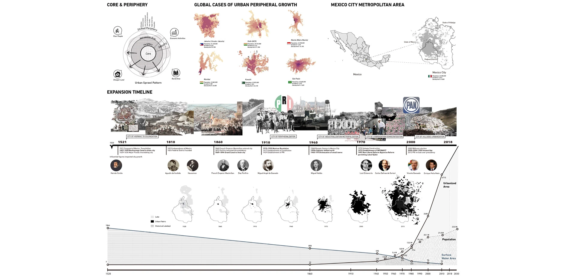
What characterizes the periphery rather than the urban core is the sense of insufficiency and incompletion, its as a frontier that serves as border with other places. People move to peripheries in seek of cheaper lands, less congestion and other factors. The majority of urban expansion is happening in metropolitan peripheries of developing countries. In the last 50 years, about 50%-90% of development happened in peripheries. Mexico City Metropolitan Area is one of major cities that has followed similar urbanization path.
Spanish conquerors drained original lakes dry through canals and tunnels; the city we see today is built on the old lake bed. Industrial development in the 1950s and agrarian reform in the 1990s pushed the city to grow outwards exponentially, and following gentrification has pushed out poorer residents to peripheries, and this further added to the dispersion of the city. Irregular self-built settlements account for 40% of urban footprints. About 30% of them are built on hillsides of the city.
INFORMAL URBANIZATION PATTERN ON HILLSIDES
In the past several decades, we have seen a growing pattern of urban sprawl on the hillsides in peripheries, and most of them are self-built irregular settlements. As the city continues to increase another 3 million people in three decades, more irregular settlements will come.
Several reasons could well explain why this trend of occupying the hillsides would continue. A big reason is they are more affordable than flat areas. And it is safer to live on hillsides comparing to old lake bed area because of flooding and urban sinking issues caused by poor drainage system and the over-exploiting of the aquifer. Hillsides are what left that have not been urbanized and almost the only space they could seek.
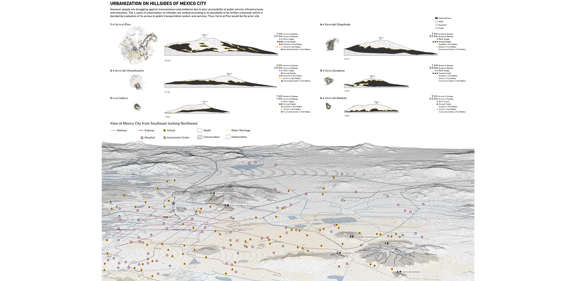
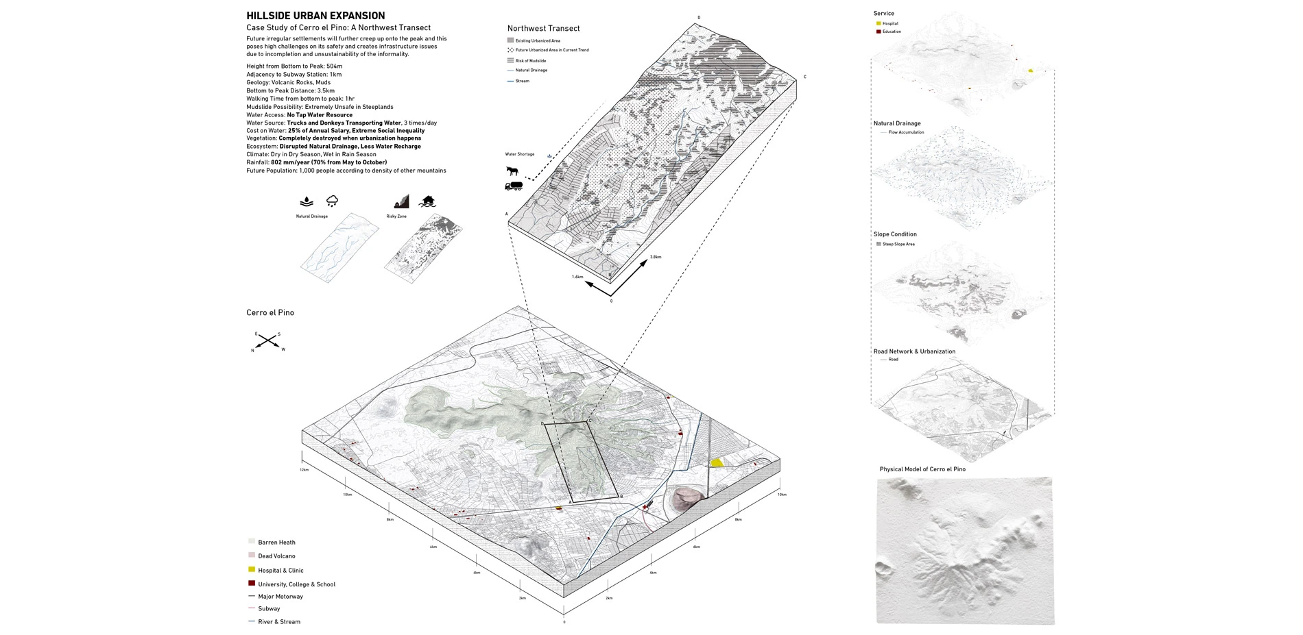
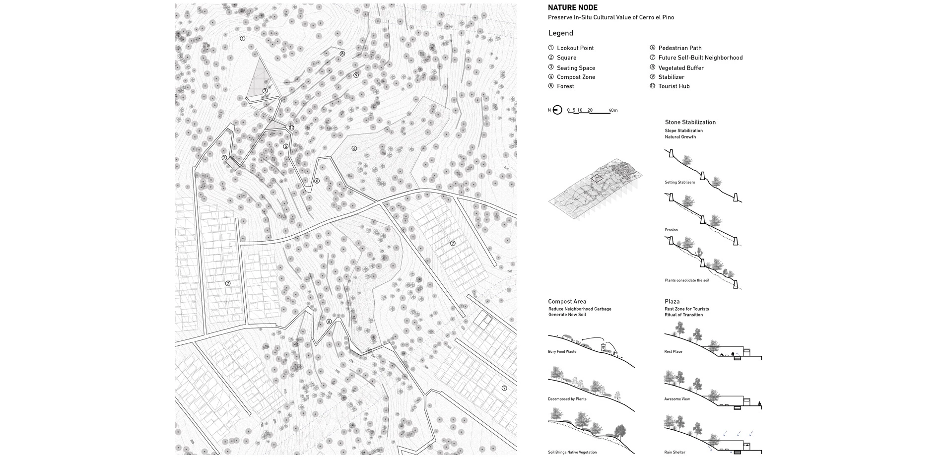
Six mountains are selected as case studies to investigate the unique urbanization pattern. Although it is decent to live on the hillsides in some way, people are also suffering from other problems. Because of the incompletion and unsustainability of current informal urbanization model, people there frequently lack basic services, such as water supply, sanitation, accessibility, education, health, and amenities. The case study sites are analyzed and ranked to find the priority site to be further urbanized soon. Cerro el Pino would be the prior site to be intervened because of its good access to public transportation system and public services.
ISSUES TO BE SOLVED
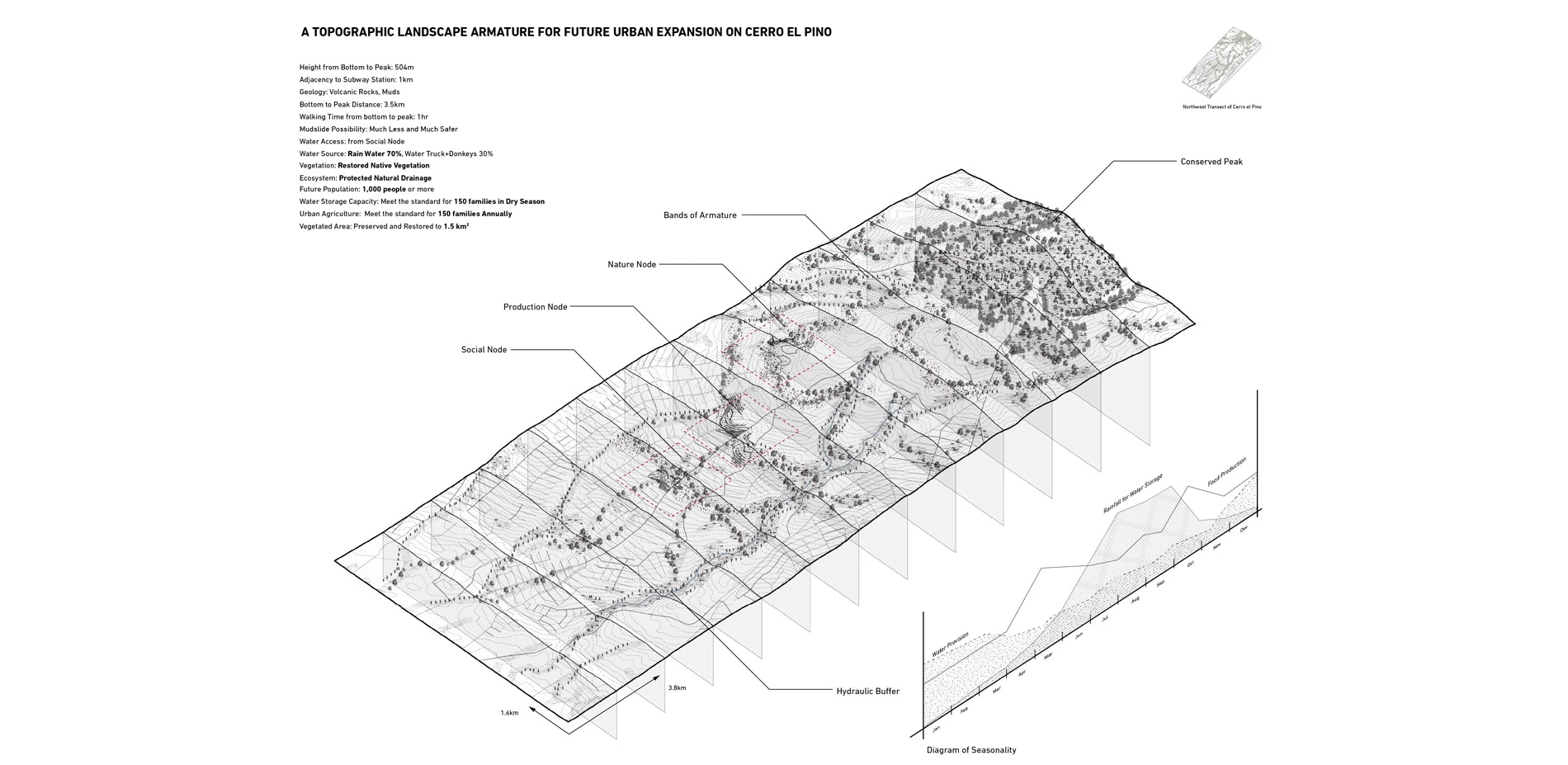
The northwest transect from the peak to bottom of the hill is selected as a testing site to implement design strategies. Here, we have seen growing urbanization in the past ten years and irregular settlements are arriving. Comparing with density of other hills, it will add another 1000 people. Settlements will further creep up and cover the mountain, destroying vegetation that recharges rainwater into aquifer and protect the soil from becoming unusable dirt and dust. Lack of trees and steep lands in turn put this place at high risk of mudslides and flash floods during the rain season. Lack of water infrastructures would force people to pay almost a quarter of their salary relying on trucks and donkeys to transport water. All these issues would plague neighborhoods and make it inconvenient and unsuitable to live without proper interventions.
INTENT AND STRATEGY
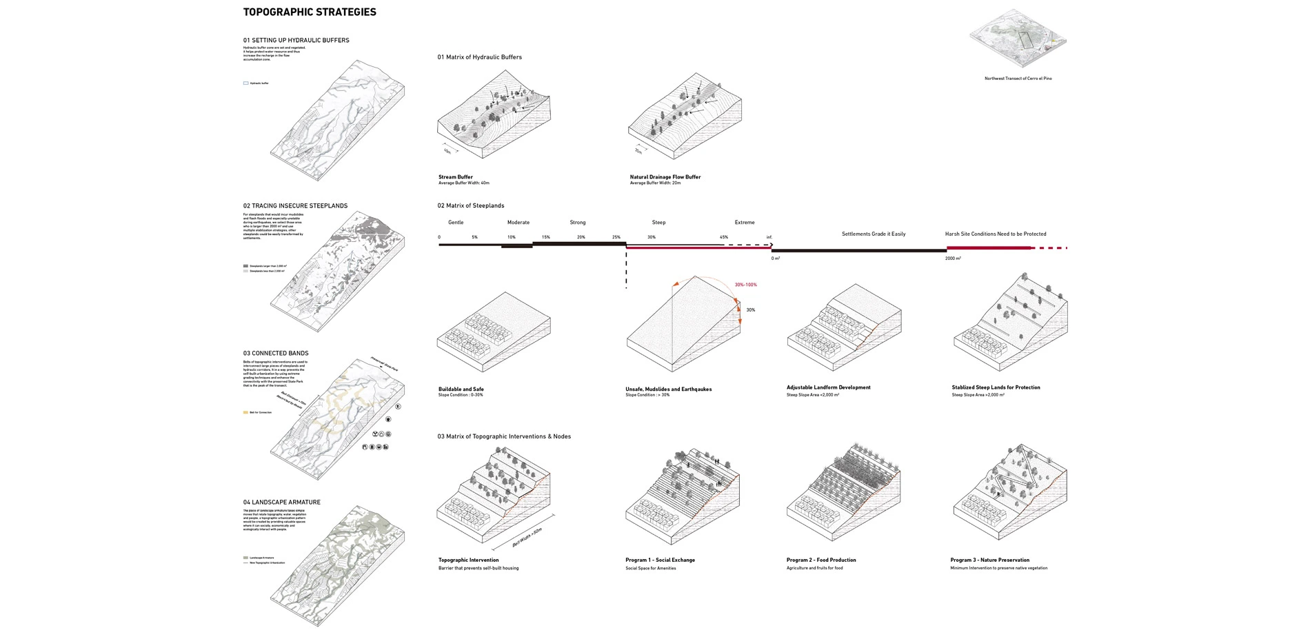
In response to current informal urbanization pattern lacking infrastructural provision and open space which increases social inequality, this project introduces a topographic landscape framework that acts an open space armature, manages informal growth and addresses needs of people in existing and future neighborhoods through the insertion of social-economic and ecological amenities.
The first step is to set hydraulic buffer zone and vegetate them, it helps protect water resource that would be the foundation of a mountain ecosystem and increases the water recharge in the flow accumulation zone. Then we trace those steep lands which are unsuitable for settlements self-changing topography and prone to mudslides and flash floods in the rain season.
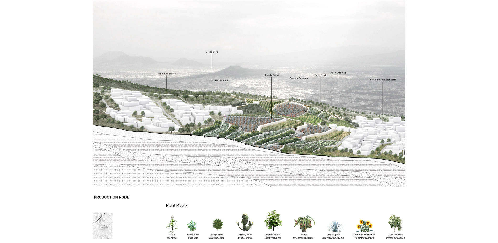
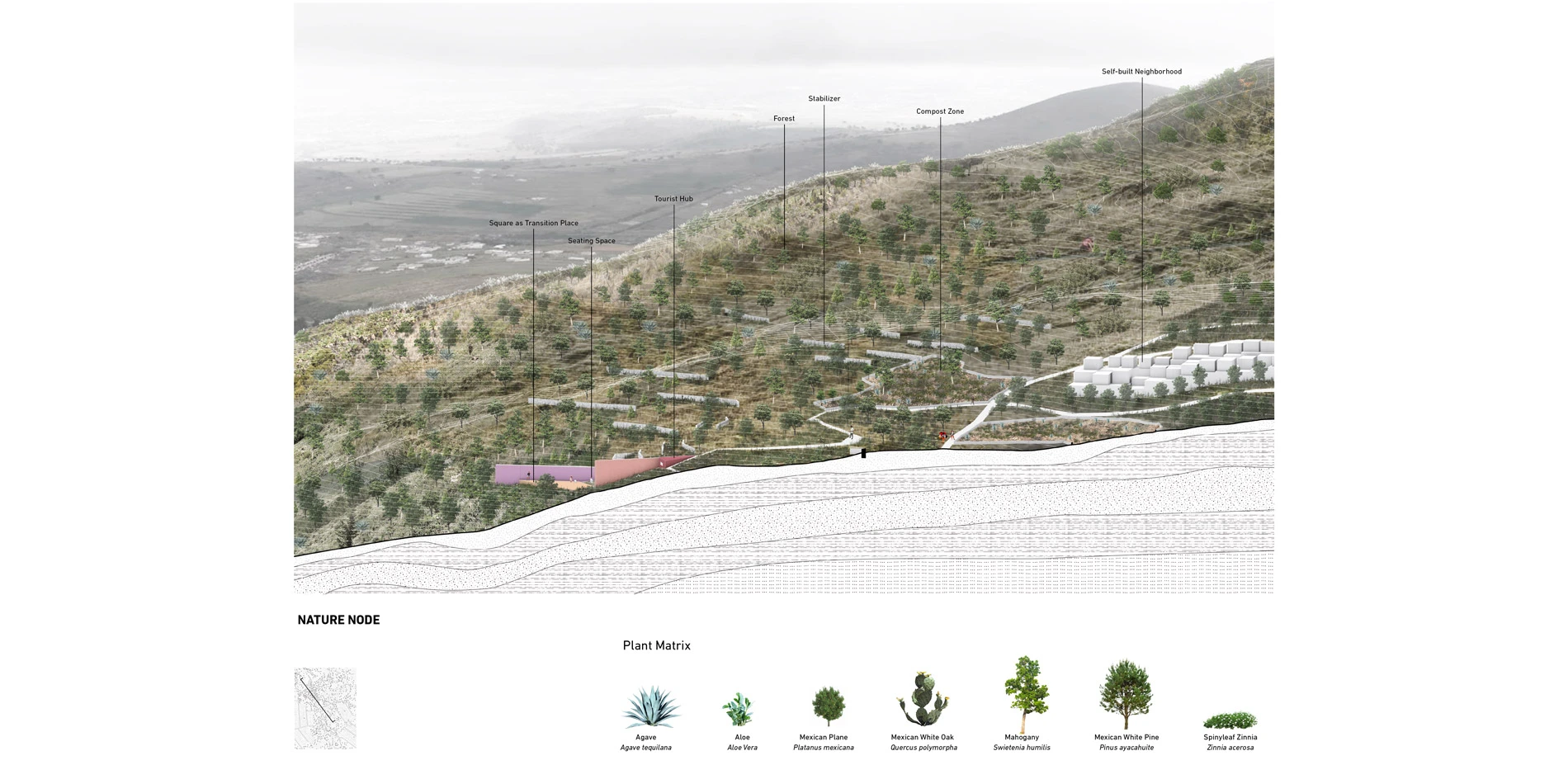
Belts of topographic interventions are set to interconnect large pieces of steep lands and hydraulic buffer zone. It is taken as an open space armature framework. On the one hand they prevent the self-built urbanization by using grading techniques and mass vegetation, on the other hand they protect people from dwelling in unsafe areas. This helps demarcate safe areas where future self-built city can grow, and bring social, agricultural, cultural benefits into the armature. The hierarchy of these bands is related to distance to bottom or peak. Belt in lower part of the hill is with more social function, stores water, purifies sewage and creates public open space. Belts in the middle are more about production. Closer to peak the slope is very steep, and so it is appropriate to make it natural and reduce possible interventions.
This piece of landscape armature takes simple moves that relate topography, water, vegetation and people, a new topographic urbanization pattern would be created by providing valuable spaces where it can socially, economically and ecologically interact with people.
NODES WITH AMENITIES PROVISION
Walking from bottom to peak, sharp different feelings and emotions could be experienced along nodes. These nodes are along intersection points of belts and major roads. Comparing to the current urbanization model, the nodes stores water for 150 families and provides their food, in the meantime conserves the environmentally sensitive and open space.
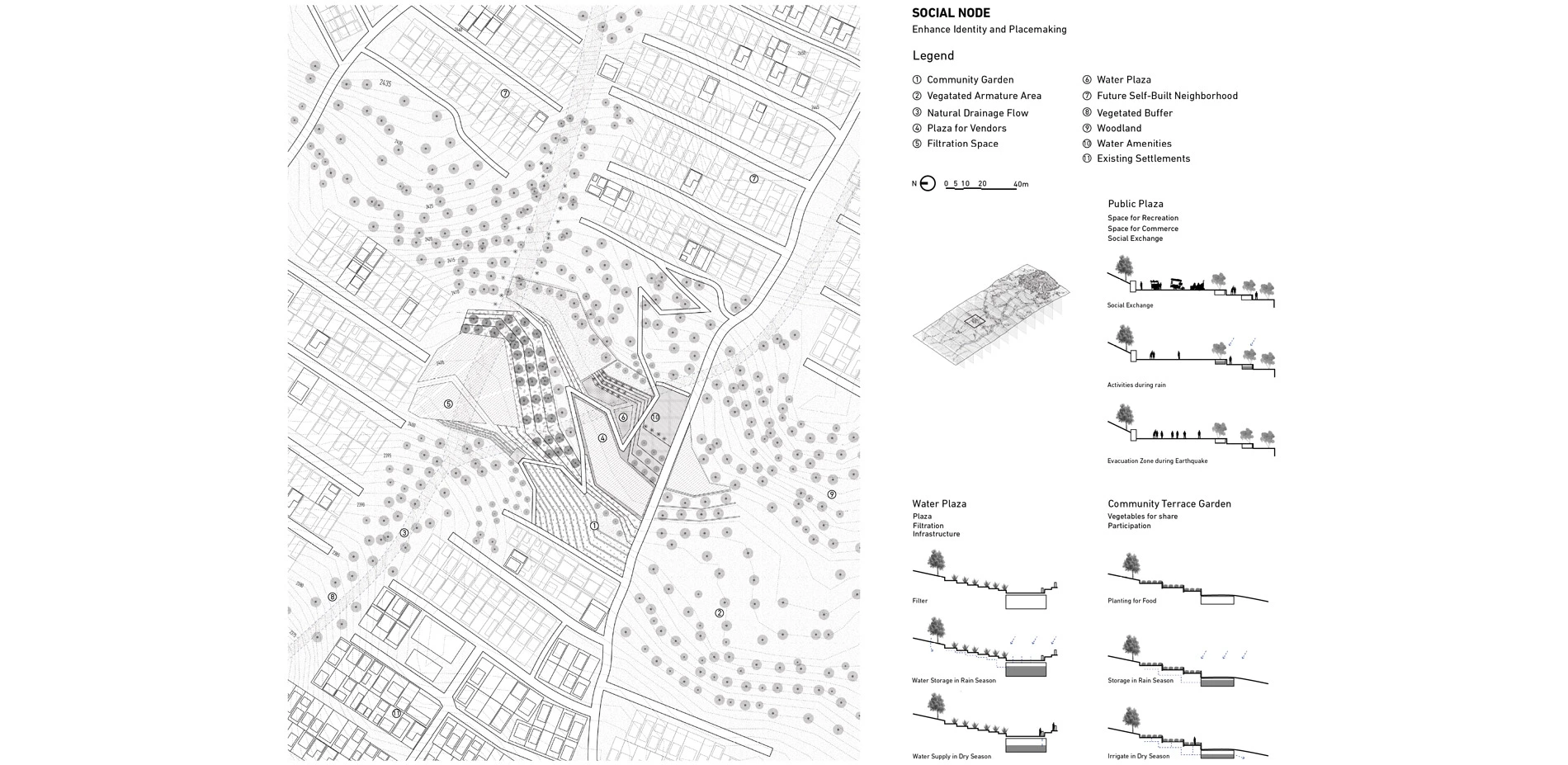
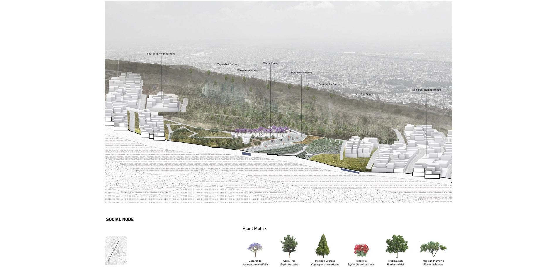
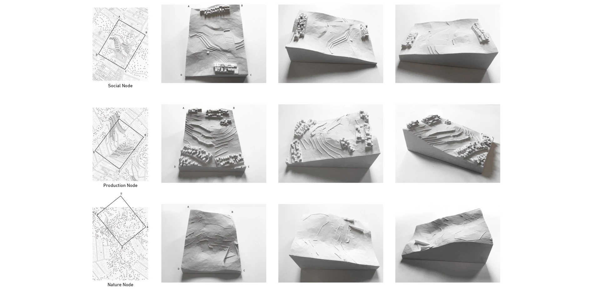
Social Node: It is about social exchange and water infrastructure. It connects lower and upper neighborhoods. It is meaningful to create a social encounter point for residents to meet, share public amenities and it brings new vitality. The underground water tank collects water in the rain season and serves people without water access as a reliable drinking source in the dry season. This supports around 100 families in the dry season, this greatly reduces their dependence on water trucks and donkeys. Another piece of land is terraced to grow vegetables for neighborhoods. Plazas could be used as space for vendors to sell products to promote economic activities, also as an evacuation place during earthquakes. Special plants such as Jacaranda trees are selected to make the space identical and be a place marker.
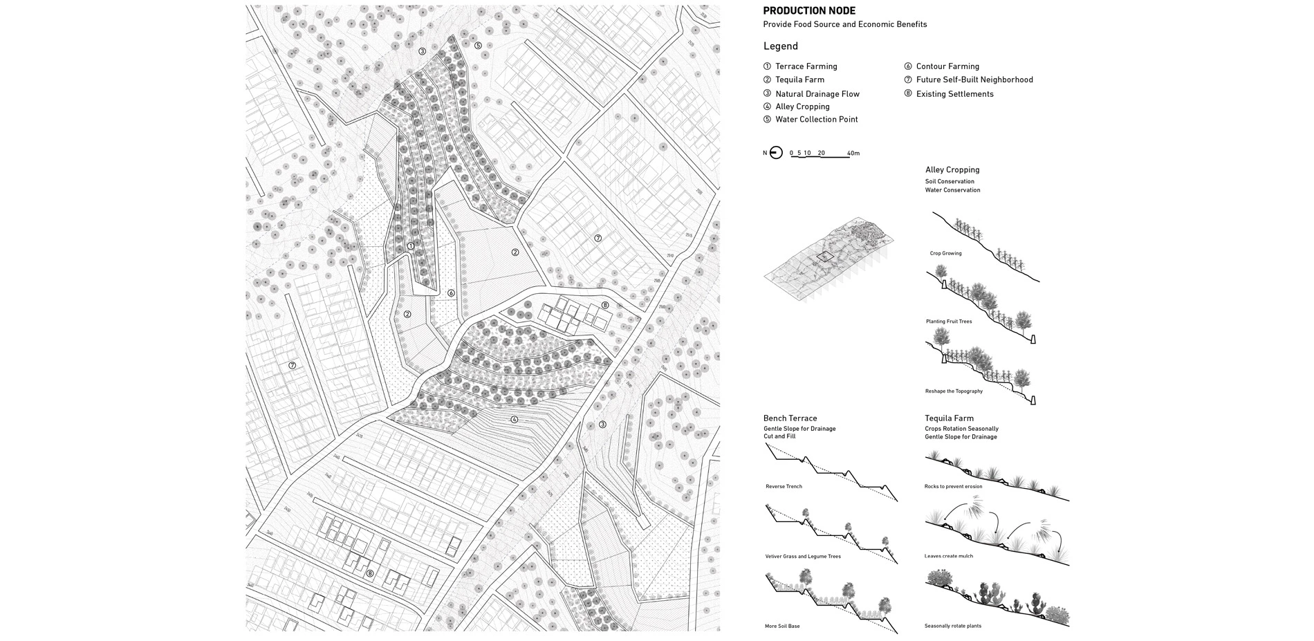
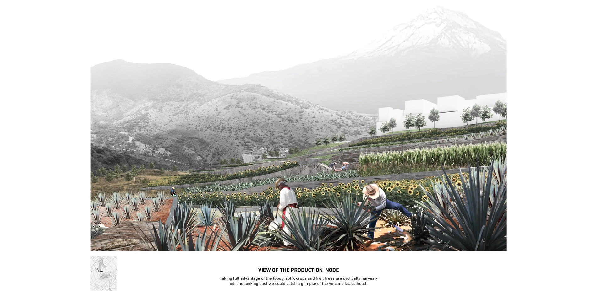
Production Node: It is to reshape the topography and make full advantage of terrace farming, alley cropping and other techniques to conserve water for irrigation. People nearby could utilize the place to get their own food source. Native crops and fruit trees are selected and rotated seasonally. Agave plants make it special and attracts more tourists. Looking west, you would catch a glimpse of the Volcano Iztaccihuatl.
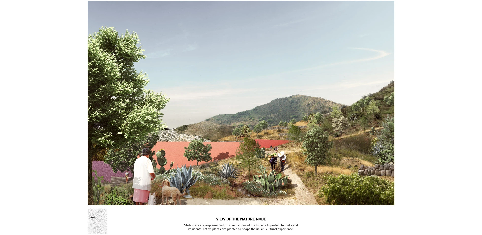
Nature Node: Due to steep slope condition, we use limited interventions like stabilizers to make it safe to connect to the conserved state park on the peak and set up a zone for food waste compost from local neighborhoods. It brings back native vegetation that has been lost in the process of urbanization. Several look out points are set as "ritual of transition" for tourists to rest, contemplate and appreciate the beautiful view of Mexico City. It provides a vivid sample of the Mexican Ecology.
LONG-TERM VISION
The strategy could be further applied to other mountains in Mexico City. It requires collective efforts and collaboration among international organizations, local communities and governmental authorities. Existing Irregular settlements in unsafe lands will be relocated. The public space authority AEP (Autoridad del Espacio Publico) needs to take over the implementation of the topographic interventions. And the infrastructure parts could be sponsored by CONUGUA and the World Bank and be installed by the company Isla Urbana. Residents would be involved in building productive farmland and the landscape to support the maintenance as well.
This project strives to find a pre-emptive way to bring open space and amenities together before settlements arrive and create an armature system that would be both beneficial to self-built neighborhood and the mountain ecosystem in the long run.
-
Bibliography
- 1. Abdoumaliq Simone, “At the Frontier of the Urban Periphery,” Sarai Reader 2007: Frontiers(2007), 462-470.
- 2. De Urbanisten, Towards a Water Sensitive City. AEP, Deltares , 100 Resilient Cities Office CDMX and UNAM, 2016. Accessed July 21, 2016.
- 3. Felipe Correa and Carlos Garciavelez, Mexico City: Between Geometry and Geography,( Applied Research and Design, 2014).
- 4. Gabriel Kozlowski, “Framing Dispersal: Urban Strategies for Mexico City’ Sprawl” (M.Sc. Thesis, Massachusetts Institute of Technology, 2015).
- 5. Herbert Ypma, Mexican Contemporary: World Design Series, (Thames and Hudson, 2014).http://www.urbanisten.nl/wp/wp-content/uploads/2016.07.21_Reporte_CAF_Urb-AEP_lr-2.pdf.
- 6. Liette Gilbert and Feike de Jong, “Entanglements of Periphery and Informality in Mexico City,” International Journal of Urban and Regional Research (Volume 39, Issue 3),518-532.
- 7. Shlomo Angel, Alejandro M. Blei, Jason Parent, Patrick Lamson-Hall, and Nicolás Galarza Sánchez, with Daniel L. Civco, Rachel Qian Lei, and Kevin Thom, Atlas of Urban Expansion (Lincoln Institute of Land Policy,2016).
- 8. Victor M Rico Espinola, “Neo Volcanic Trans-Scalar Orders- Eastern Mexico City: A Pilot for Interfacing Territories and Architecture” (MAUD Thesis, Harvard University, 2014).
For this project, I really appreciate tremendous help from my dear advisor, Prof. Fadi Masoud, for all his great guidance from selecting sites to the final representation. Without his dedication to my project, I couldn't imagine finishing such a challenging project. And also, I would like thank Victor Espinola for his inspiration and kind help on providing report about Mexico City. I want to thank Gabriel Kozlowski for his thesis project informs me the urban sprawl history of the city and information about informal settlements. Many thanks to Daniel Carranza for he gave me the chance to watch the H2O mx Documentary and learn more about the background information. And thank to my family for their strong support on me. Many thanks to my girlfriend, Meikang Li, for her strong technical help and support to push me further deepen my project. Thank Prof. Alissa North on her guidance during the Thesis Preparation Course and guided my direction of thesis. Thank Prof. Justine Holzman for our discussion on my thesis during the Advanced Site Technology Course. Thank Prof. Liat Margolis for her advice on research about informal settlements. Thank all the guest critics during the final presentation, they inspire me to continue this project in the future. Thank Shaine Wong for her great and detailed advice on my thesis. Thank to all my classmates and friends for their communication with me and support and push me to continue and never give up.
Photos:
- View of the Hillsides Urbanization top photo: H2Omx (documentary in 2014) 2nd photo: Redacción El Big Data middle photo:Feike de Jong 4th photo: C.S. Ecatepec bottom photo: Johnny Miller
Advertisement
Related Awards

Honor Award, Analysis & Planning
A Cultural Approach: The Fort Peck Tribes Hazard Mitigation Plan
In collaboration with the Fort Peck Assiniboine and Sioux Tribes, EPA, and FEMA, the Fort Peck Tribes Hazard Mitigation Plan (HMP) adopts a culturally responsive approach to hazard mitigation planning that features connection to place.

