
.webp?language=en-US)


Waters in Peril: Collective Measures for a Dying Lake Winnipeg
Jaysen Ariola, Student ASLA


It’s so subtly rendered and beautiful. By their taking the time, we’re able to see the power of the proposal.
Awards Jury
-
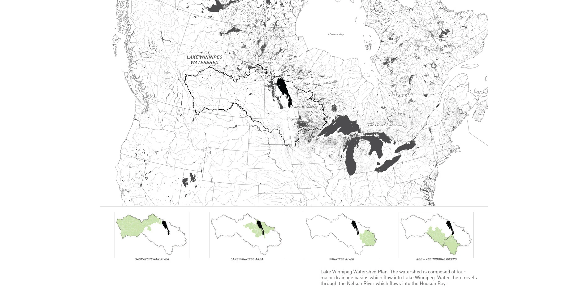
Lake Winnipeg is one of the largest freshwater lakes in the world. The territory of the Lake's watershed crosses many jurisdictions of Canada and the United States. The Lake is an integral part of Manitoban heritage, as it is celebrated for its many beach communities.Due to heavy nutrient loading within the watershed, Lake Winnipeg is known as one of the most threatened lake in the world. Industrial agriculture in the region has resulted in waterway changes and ecosystem service loss. This project will examine how changes in landscape policy and ecological planning can mitigate nutrient loading from the Red River into Lake Winnipeg. The project seeks to develop a landscape framework, which can be used by governments, environmental groups and landowners to combat issues that Lake Winnipeg is facing.
-
This project looks at how landscape architecture, planning and policy making can help mitigate effects of nutrient loading into Lake Winnipeg.
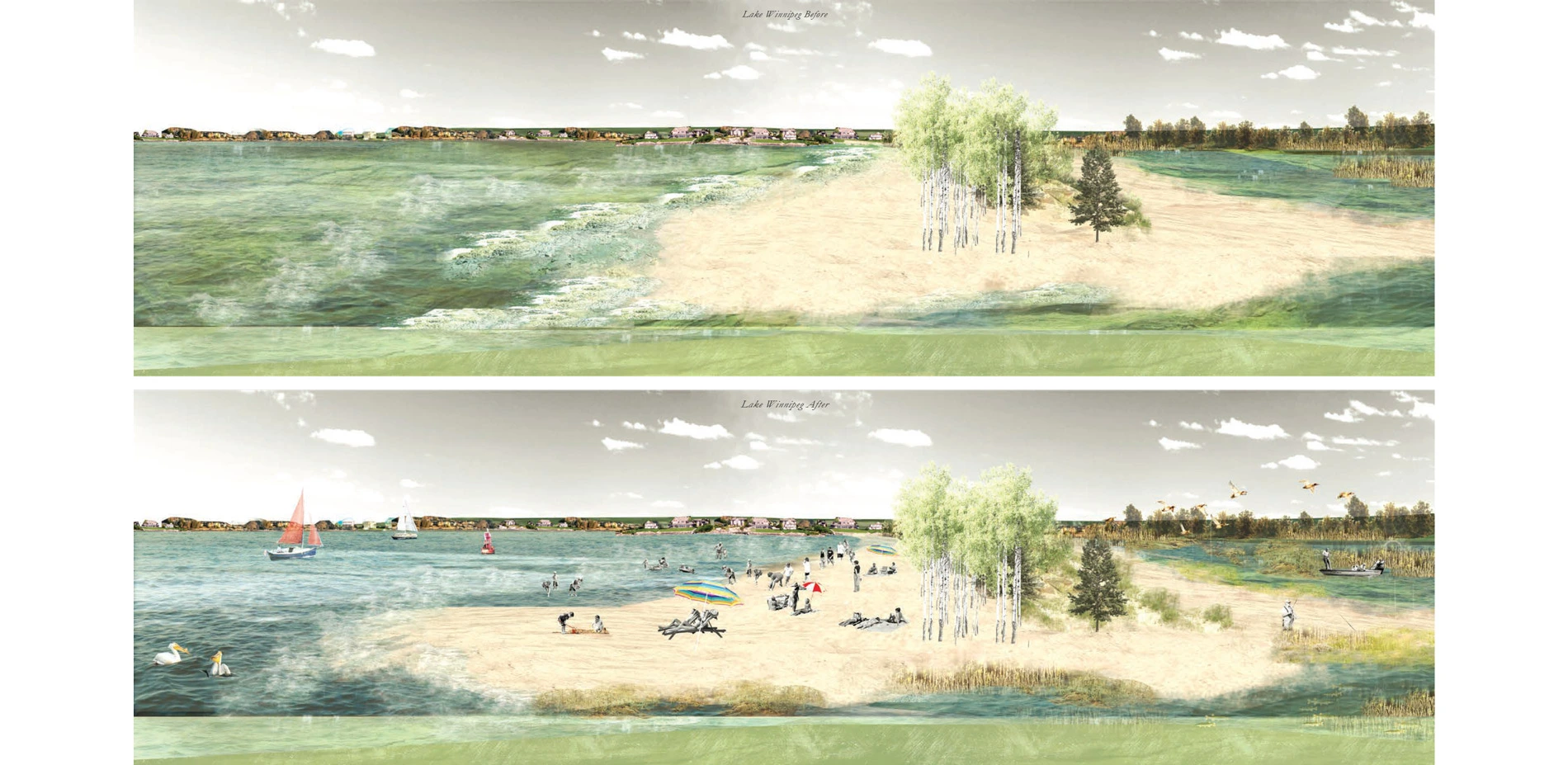
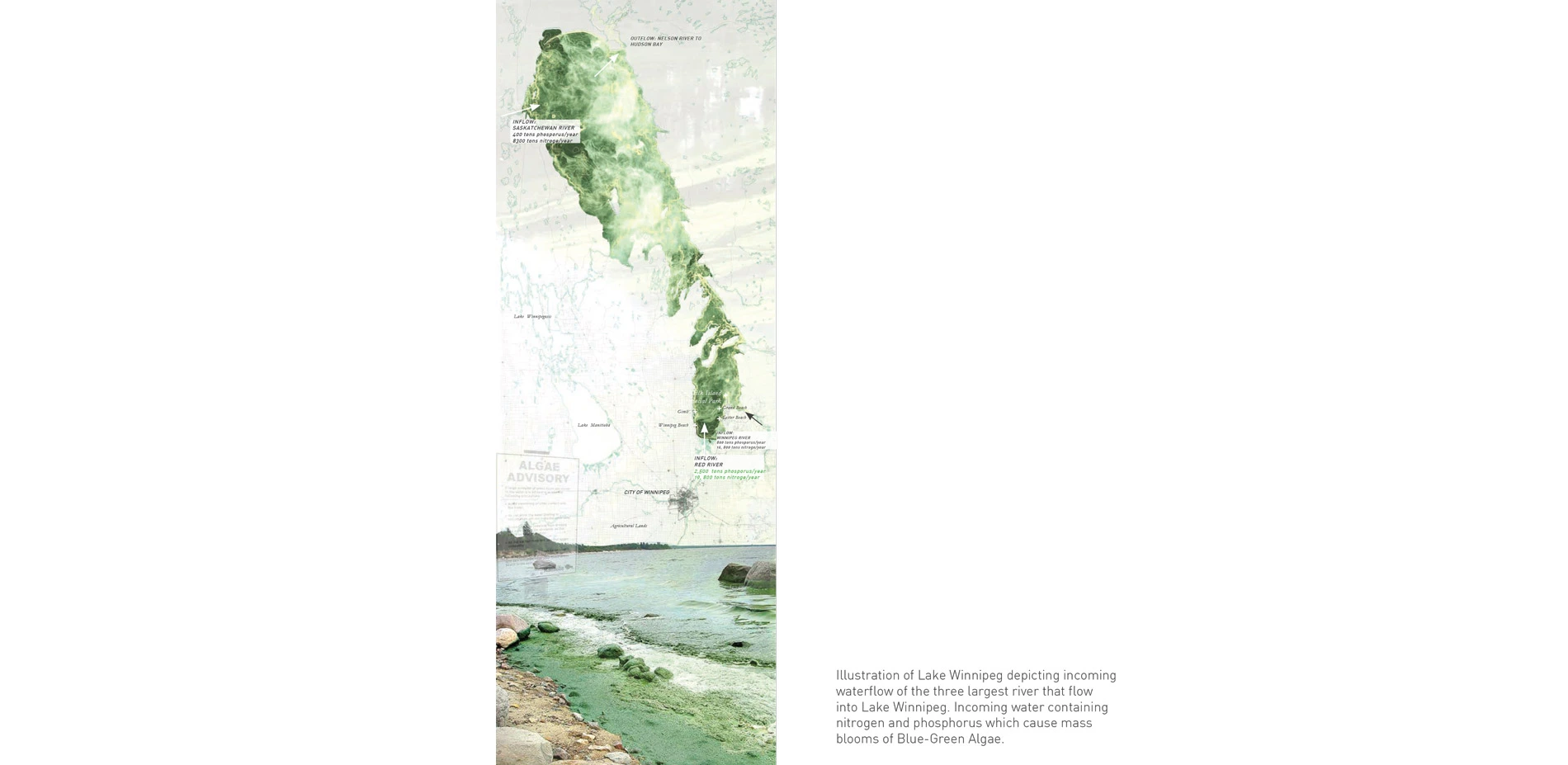
Lake Winnipeg is the tenth largest freshwater lake in the world. Although a very large lake in terms of total surface area, it is very shallow. The lake is the remnant of glacial Lake Agassiz, which covered much of North America. The territory of Lake Winnipeg's watershed covers much of Canada and crosses into U.S. borders.The Lake is an integral part of Manitoban heritage, as it is celebrated for the many beaches and cottage communities along its shorelines. Due to heavy nutrient loading and surface runoff within its watershed, it is known as one of the most threatened. In 2013 Lake Winnipeg was labeled "Most threatened lake of the year" by the Global Nature Fund. This title is commonly given to lakes within developing countries. The Lake's high nutrient content cause mass blooms of Blue-Green Algae. The algae create a toxin dangerous to human and animal health. Since 2008, the Canadian government has given $61.4 million dollars towards efforts of restoring the Lake. Within the last five years, only a one percent decrease in phosphorus levels have been found. The problem does not fall within just one provincial territory, but internationally as well. Since no one entity or government has responsibility of cleaning Lake Winnipeg the situation continues to worsen.
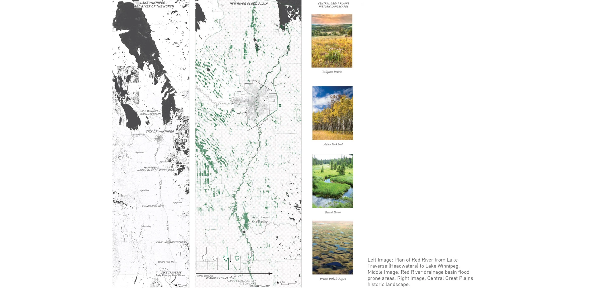
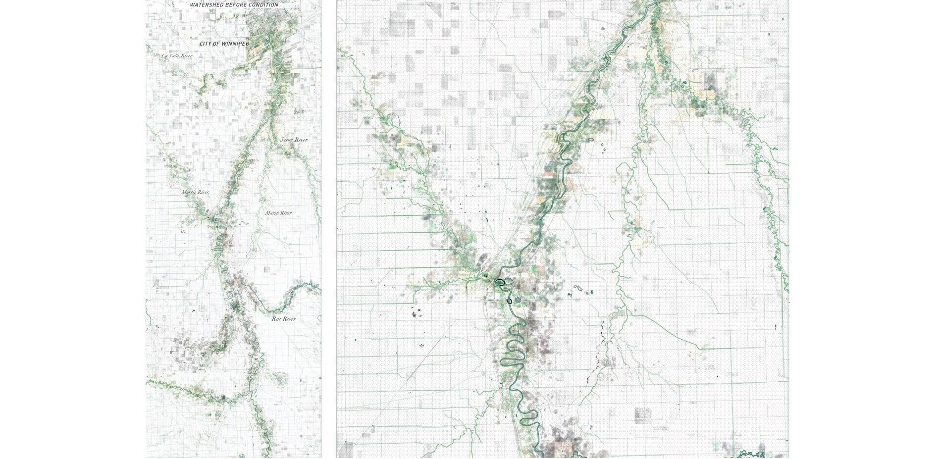
The project will focus on the Red River Drainage Basin, as nearly half of the lakes incoming phosphorus and nitrogen comes from the Red River. It originates at Lake Traverse and is the borders North Dakota and Minnesota. The Red River crosses from the United States into Manitoba and goes through the City of Winnipeg, before flowing into the southern basin of Lake Winnipeg. The Watershed is composed of nearly all agricultural land based on an imposed 1-mile grid.
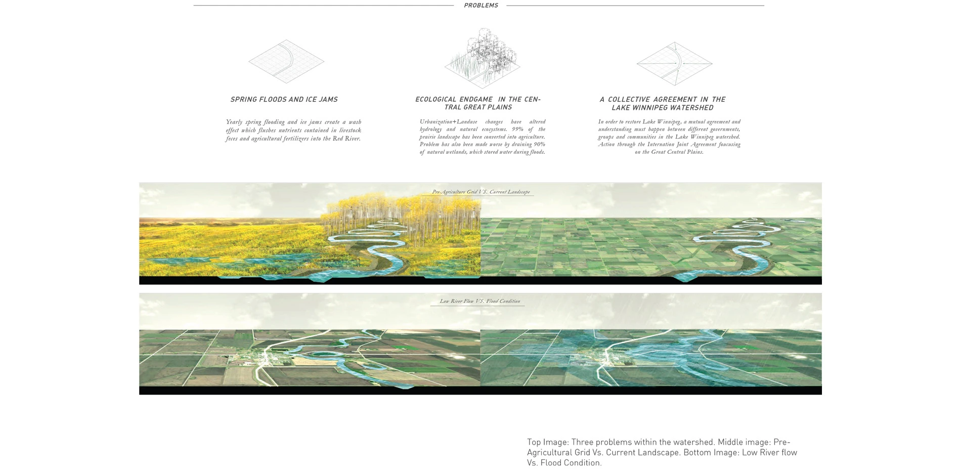
PROBLEMS WITHIN THE WATERSHED:
- Yearly spring flooding and aging infrastructure. Flooding creates a wash effect, which flushes agriculture nutrients and livestock feces in the river.
- Landscape changes as a result of urbanization and industrial agriculture within the Central Great Plains. 99% of the original tall grass prairie and 90% of natural wetlands have been converted for agriculture.
- Understanding and addressing the problem of Lake Winnipeg by multiple governments and not only as problem of the Lake but the entire watershed.
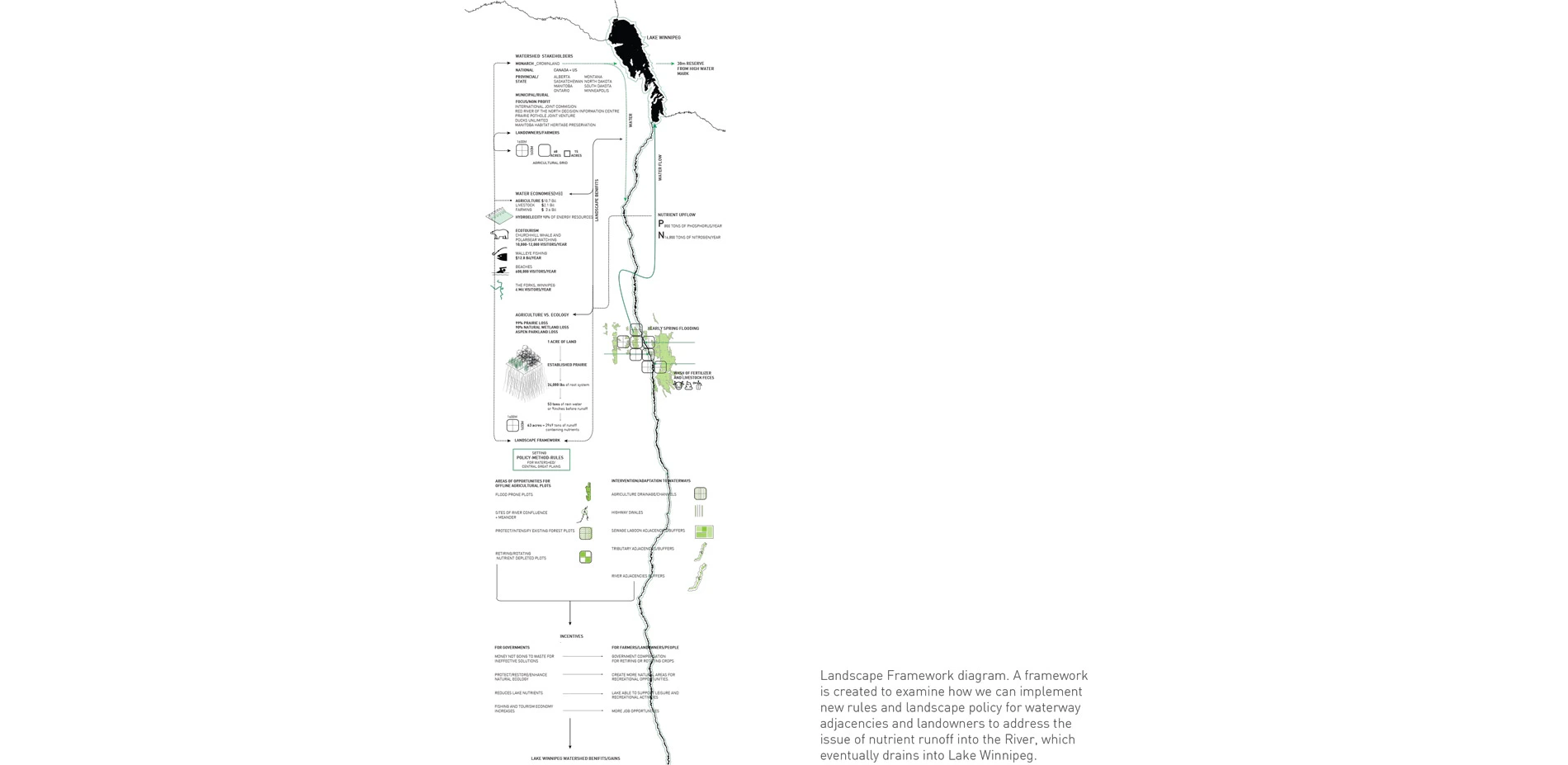
LANDSCAPE FRAMEWORK
A framework is created to examine how we can implement new rules and landscape policy for waterway adjacencies and landowners to address the issue of nutrient runoff into the River, which eventually drains into Lake Winnipeg. It outlines components such as stakeholders, economy and strategies. The framework would address and convey what it means to protect and restore ecosystems to various groups and people.
Strategies would include changes in how water travels, where it can collect and how we might start to turn certain agricultural plots offline. This would be based on mapping and analysis where we can identify conditions or opportunities of intervention; such has land prone to flooding or have greater support for ecosystem services. Finally, if we turn off or convert these plots, we can convey how much water and nutrients are detained from flowing into the river, thus reducing nutrient loading into Lake Winnipeg. 1 acre of established prairie produces 24,000lbs of roots, which can intercept up to 53 tons of rainwater or up to 9 inches before runoff.
The framework then gives incentive to various levels of government like sustained economy, more jobs created and a celebrated heritage landscape. Governments can then start to purchase plots or incentive can be given to landowners to obey policy and make landscape and drainage changes to their farming practices. Farmers could receive a sum for the acreage or annual stipend for acreage turned over.
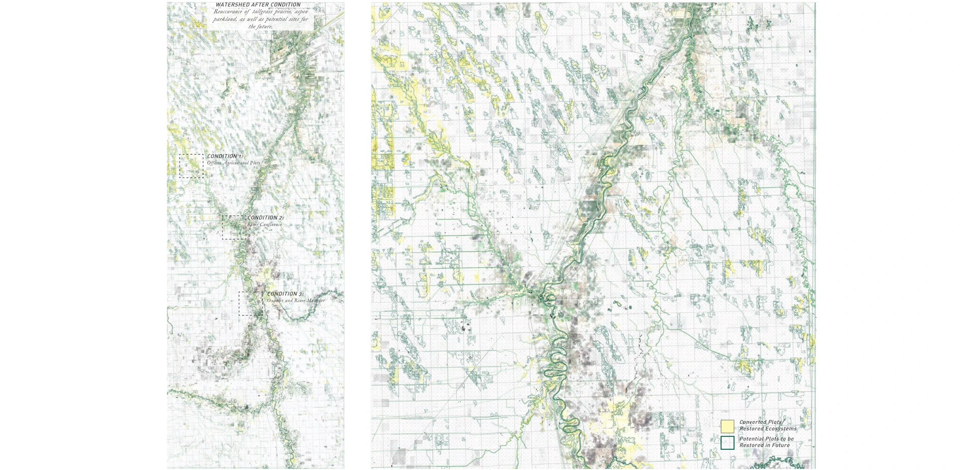
IDENTIFYING CONDITIONS / INTERVENTION
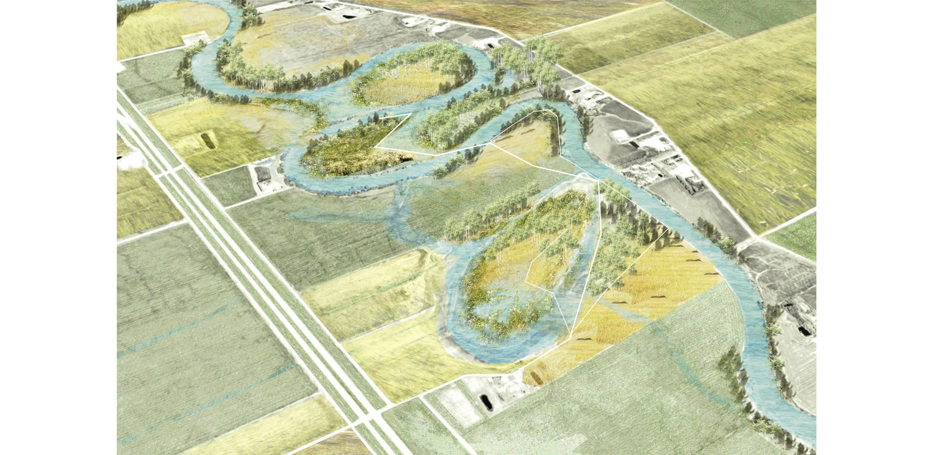
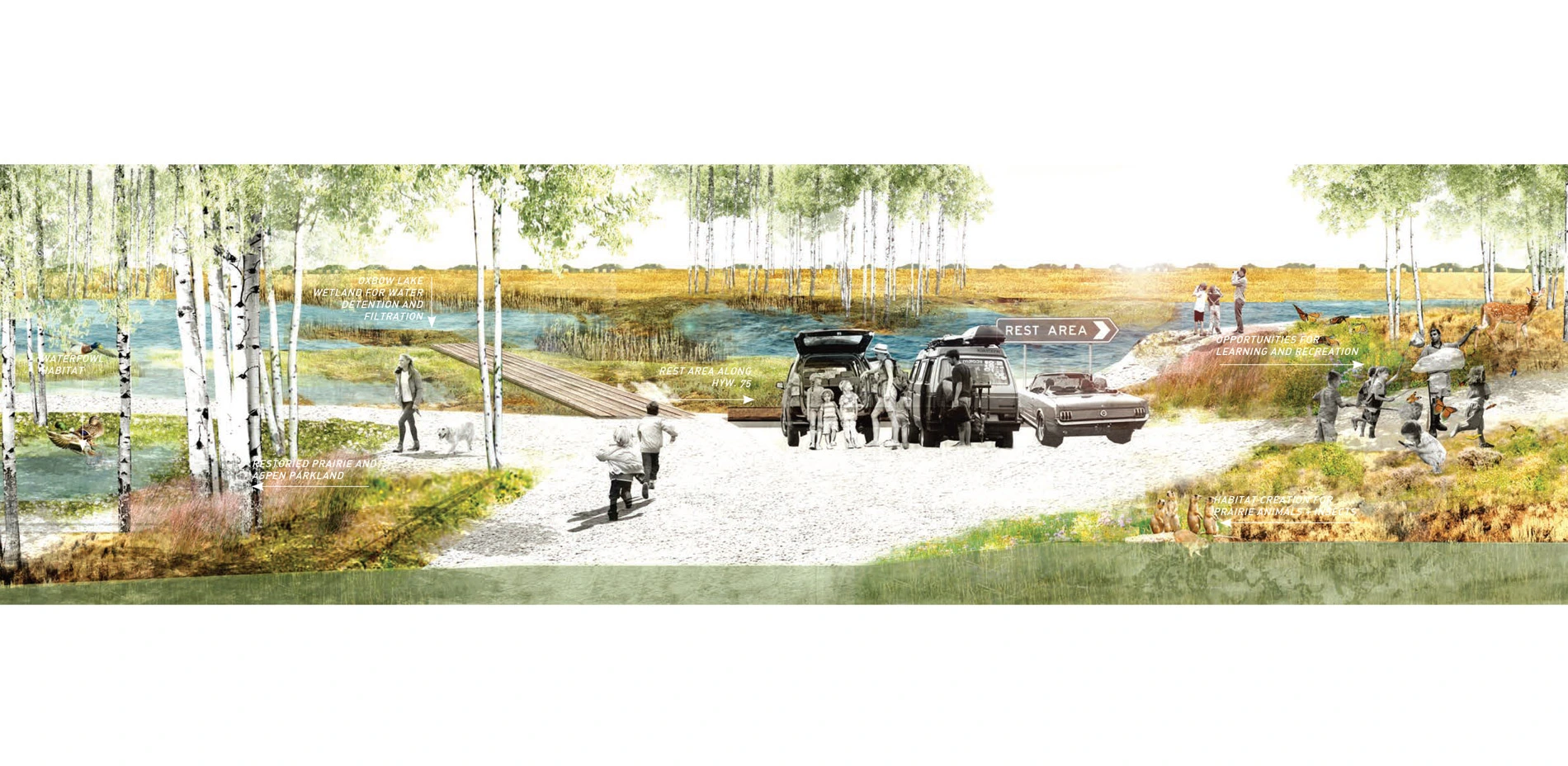
Condition 1: Meanders and Oxbows
Rivers meanders and Horseshow bends created by natural river dynamics are prone to flooding overtime. These horseshoes create remnant oxbow lakes or wetlands, which are cut off from the river. We can claim these spaces and allow them to flood and detain water. The Red River runs parallel to Highway 75, which runs north-south towards Lake Winnipeg. The highway is used for travellers going to their cottages, beaches or fishing up north. This condition is an opportunity to reinvent rest stops for recreation and learning.
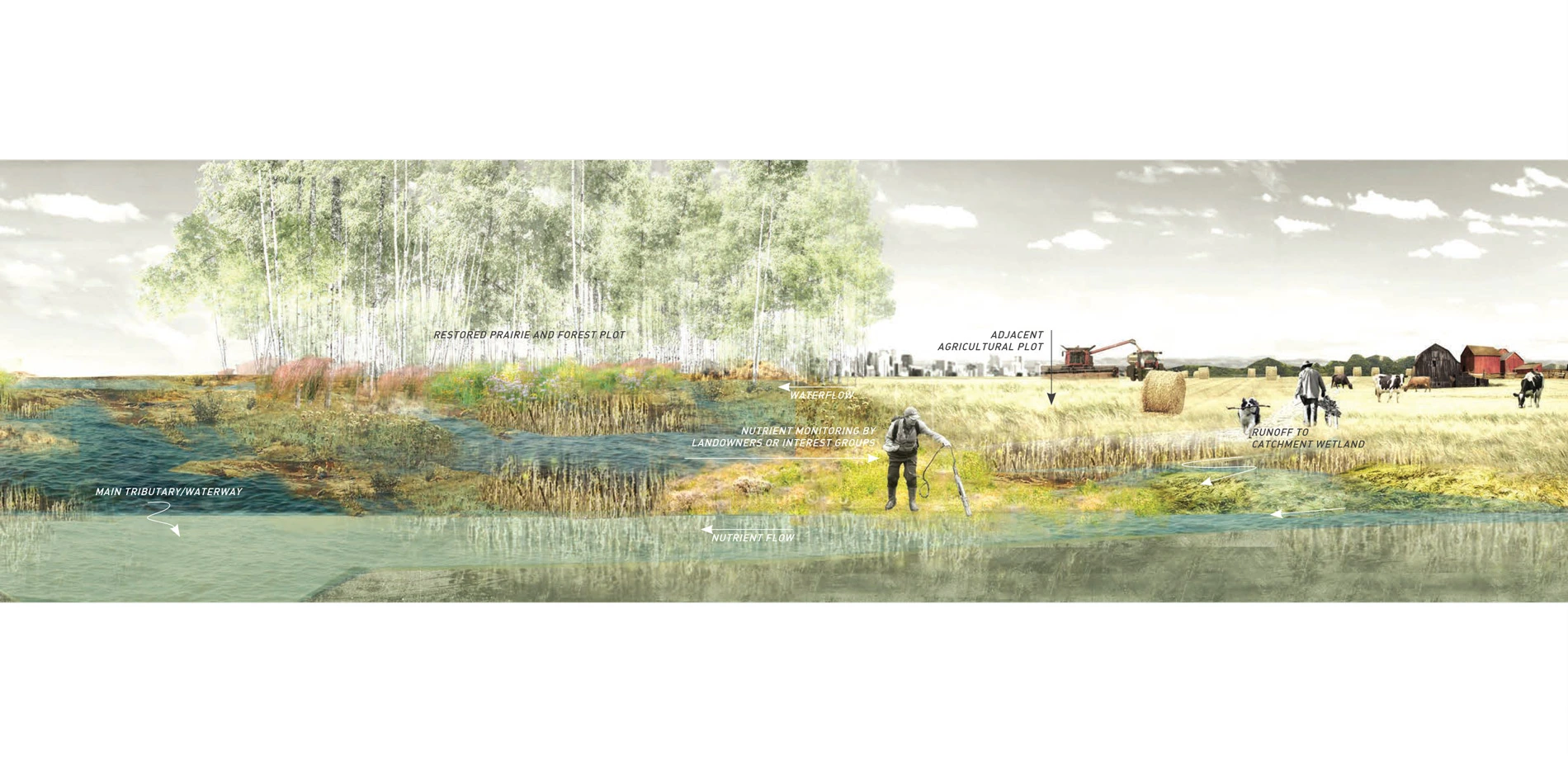
Condition 2: Offline Agricultural Plots
As a result of being within a floodplain, certain agricultural plots are deemed to be less productive. We can map out and convert these plots, or partial plots to detain water and increase buffers to existing waterways. Condition 2 is a site where a river tributary meets a drainage channel. The intervention observes the relationship between a farming practice and an adjacent converted plot where drainage can collect towards wetland, forest or prairie before it drains into the tributary. There is also an opportunity where farmers or environmental groups can monitor water quality levels at these plots.
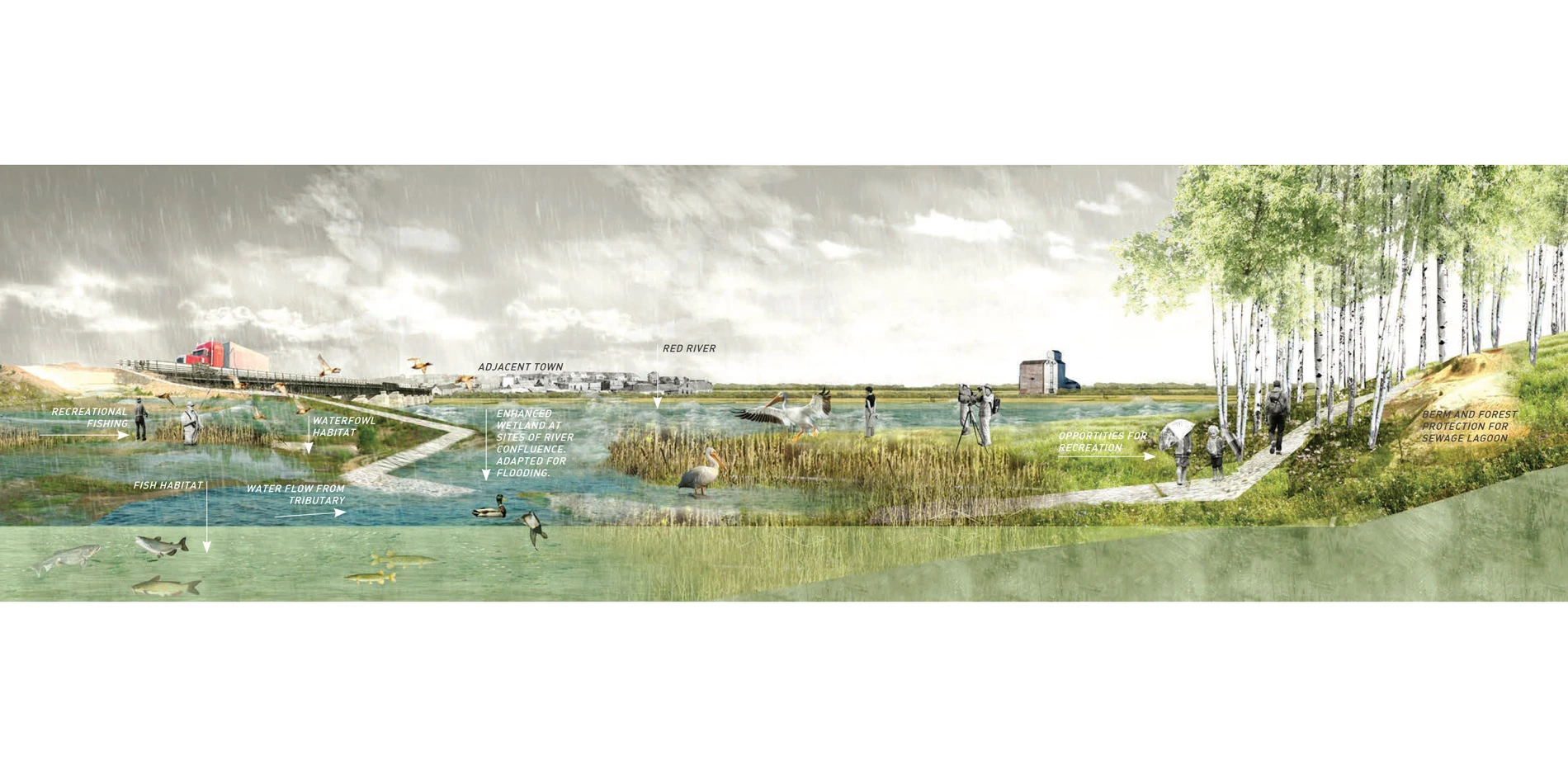
Condition 3: River Confluence
The Red River sees several points of confluence along its length. These tributaries form secondary river systems of various sizes and complexities. These points have the opportunity to support ecosystem services and several other benefits. The site is a rural town, which sits along the Red River and a point of confluence. The site is also adjacent to a sewage lagoon, which has the potential to spill into the river during heavy flood events. The intervention shows the intensified wetland at the confluence and the ecosystem service it might provide. There is also an opportunity to weave in recreational value to the town. This intervention also supports flooding during a storm event while a planted raised berm protects the sewage lagoon.
CONCLUSION
Because of landscape policy and planning put in place, or at least within the Red River drainage basin, we can mitigate effects of nutrient loading in Lake Winnipeg. We can go from the lakes current degraded state to a future where it is celebrated. We can hope for a future where we start to see waterway adjacencies change as prairie, forest and wetlands of the Central Great Plains region come back. We need a shift in thinking and look at how we might occupy and live within the landscape over time. With this in mind, as landscape architects we have a role in creating landscapes were ecosystems are celebrated and work together with our human needs.
Advertisement
Related Awards

Honor Award, Analysis & Planning
A Cultural Approach: The Fort Peck Tribes Hazard Mitigation Plan
In collaboration with the Fort Peck Assiniboine and Sioux Tribes, EPA, and FEMA, the Fort Peck Tribes Hazard Mitigation Plan (HMP) adopts a culturally responsive approach to hazard mitigation planning that features connection to place.

