
.webp?language=en-US)


Climate Change Armor
Zixu Qiao, Student ASLA
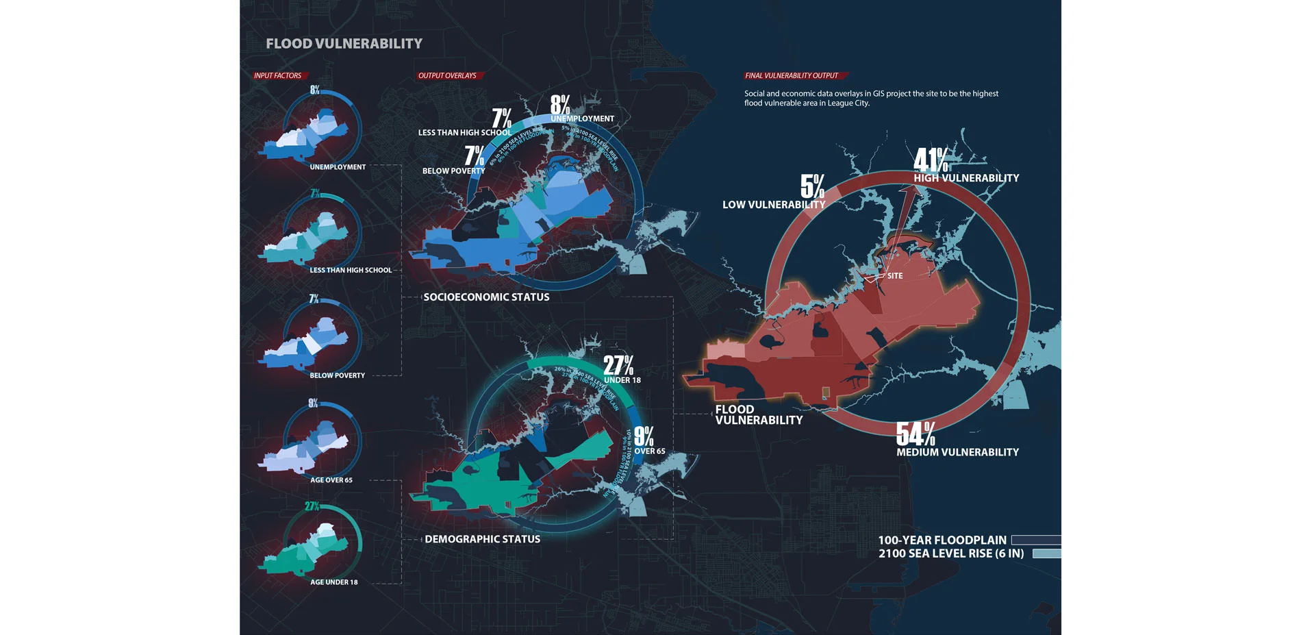
They identify who in the population are highly vulnerable and why, which helps with prioritizing implementation.
Awards Jury
-
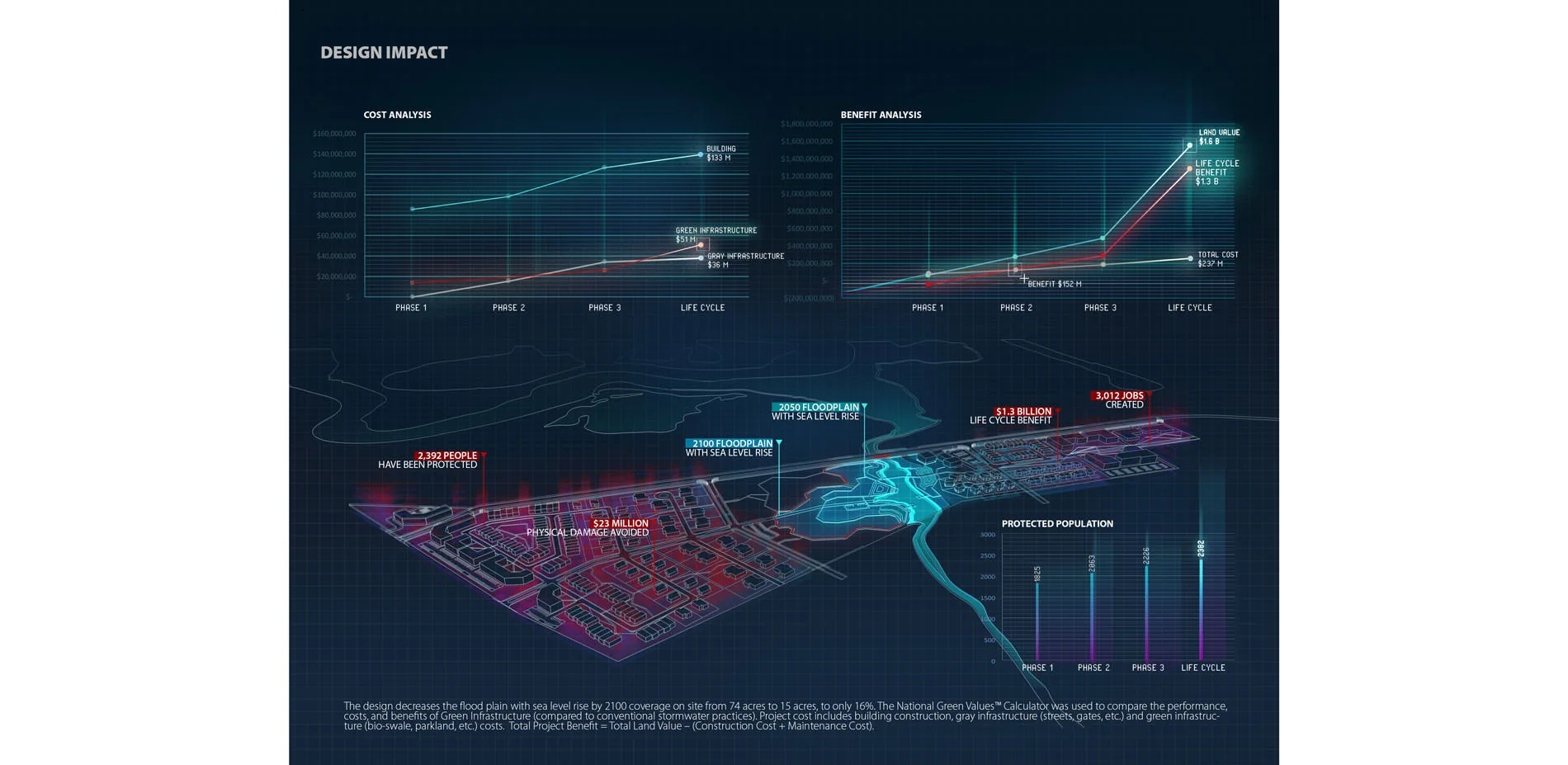
Climate Change Armor is a collection of adaptive flood attenuation mechanisms for protecting newly designed communities from flood events and the eventual impacts of sea level rise. League City, TX is used as an application site. NOAA predicts that sea levels will increase and storm surge will become more frequent along the Texas coast. In the Gulf Coast, sea level projects to rise up to 6.29 feet by 2100. The Climate Change Armor Toolkit comprises both structural and non-structural mechanisms, which are either engineered to block and control heavy floods or rely on natural systems and green infrastructure to attenuate flood waters from frequent storms or hazard flood events. With the application of the Armor Toolkit, 221,921 ft3 of runoff can be captured, nearly 2,400 new residents are protected, over 3,000 jobs are created, $23 million in physical flood damage can be avoided, and approximately $1.3 billion can be generated in the life cycle benefits of the newly designed community by 2100.
-
Background/Problem Statement
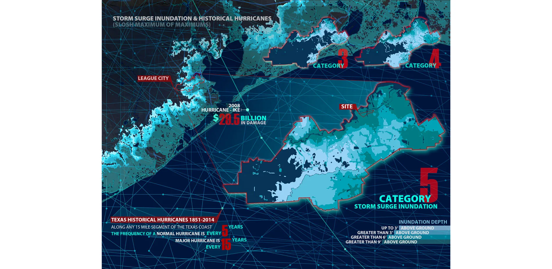
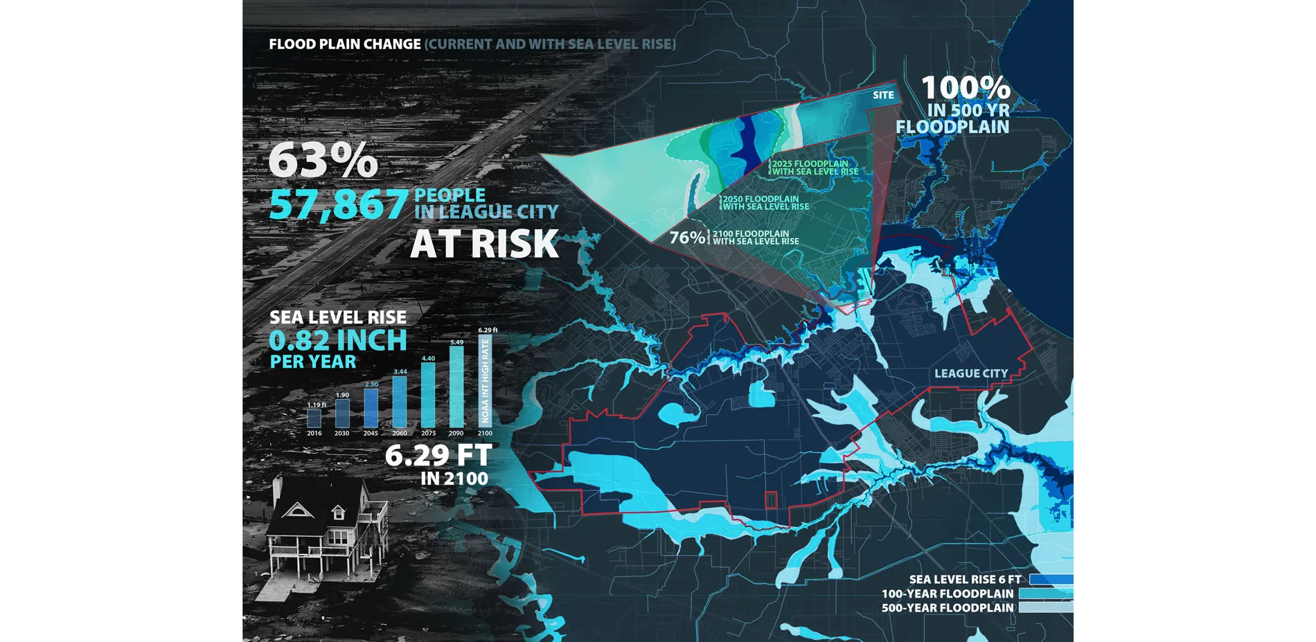
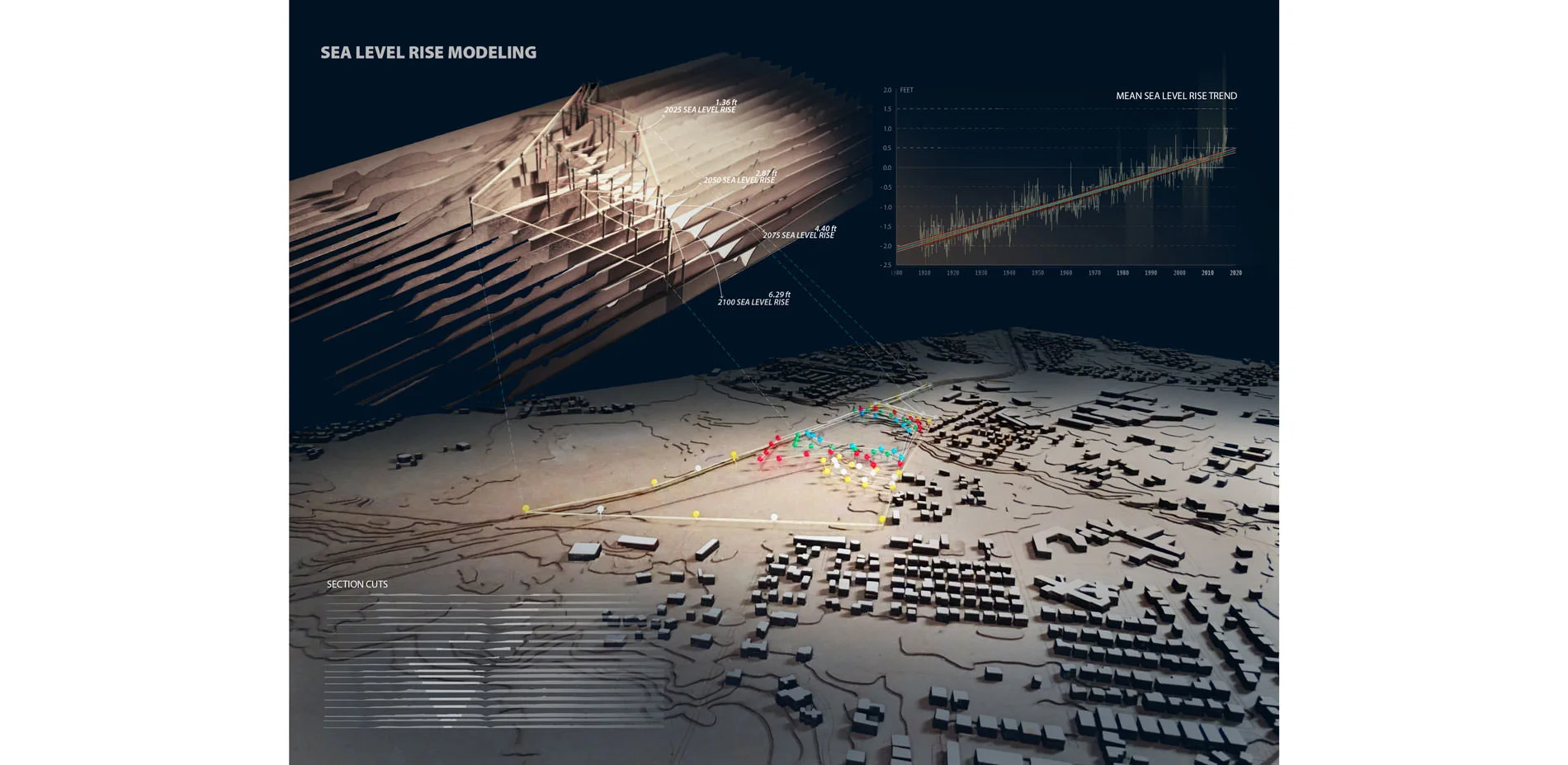
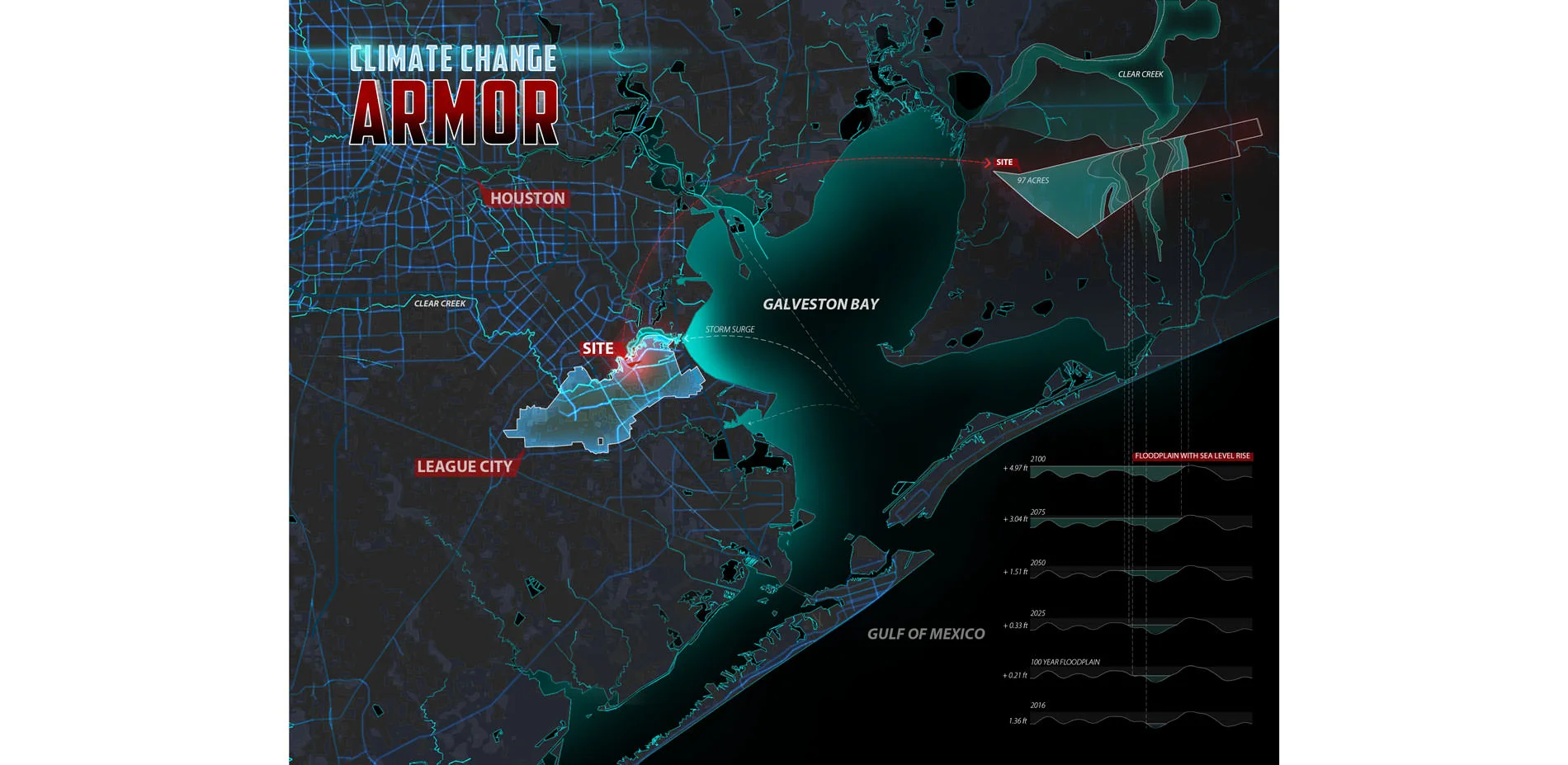
Climate change effects have had observable ecological, social, and economic impacts on the built environment. NOAA predicts that the mean sea level will rise at least 0.82 inches per year in the Gulf Coast region, reaching 6.29 feet by 2100. Sea level rise has had a significant impact on coastal ecosystems resulting in wetland loss, increased coastal erosion/inundation, and increases in the duration and frequency of flooding from storm surge. For example, in 2008, Hurricane Ike wreaked havoc on Texas, causing 113 deaths and $29.5 billion in damage; approximately 200 of the damaged homes were located in League City, TX.
Due to its location, League City is exposed to many hazards and is highly vulnerable to flood events and other issues effected by sea level rise. This project designs a resilient community within a 97-acre site surrounded by urban development in League City. The site is currently planned by the city to grow as mixed-use and auto-dominated residential urban low-density development. The objective of this project is to design a community that is fully protected from current and future flood events and the eventual impacts of sea level rise, thereby reducing physical and social vulnerability.
Regional & Site Conditions
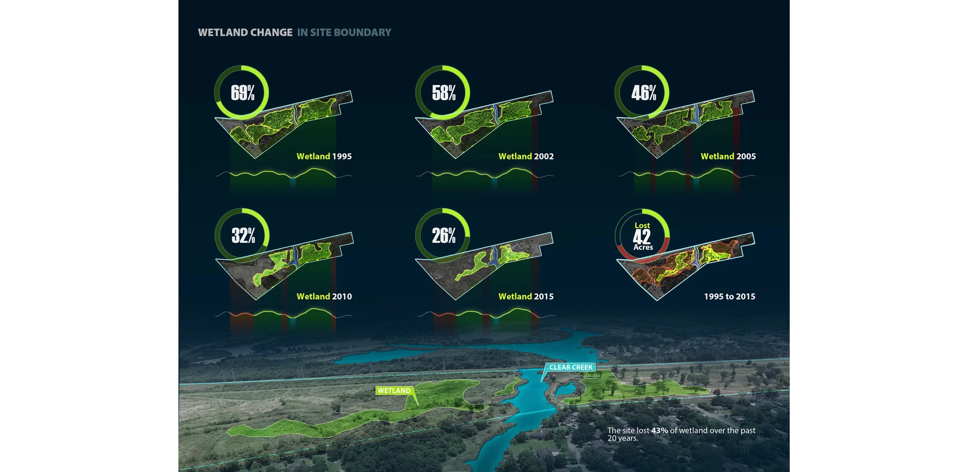
Flooding and hurricanes are major concerns along the Gulf Coast. The frequency of a normal hurricane along any 50-mile segment of the Texas coast is one about every 5 years, with a major hurricane occurring nearly every 15 years. The design site will be significantly inundated by storm surge from hurricanes from Category 3 and above. Relatedly, sea level rise will increase the vulnerability of coastal communities to hazards such as flooding and hurricanes. By 2100, nearly 50% of League City projects to be covered by the FEMA 100-year floodplain, should a 6 feet sea level rise occur; 76% of the land on the design site will be effected, and the entire site is covered by the 500-year floodplain. By overlaying social and economic raster data sets in GIS to map factors contributing to flood vulnerability, over 41% of League City projects to have high flood vulnerability, and the site rests as the highest flood vulnerable area in the city. In regards to the catastrophic damage these conditions have had on ecosystems, nearly 96 acres of freshwater wetlands and 154 acres of wetlands in the region have been lost since 2008. The design site has lost 43% of its wetland area in the past 20 years.
Design Strategy
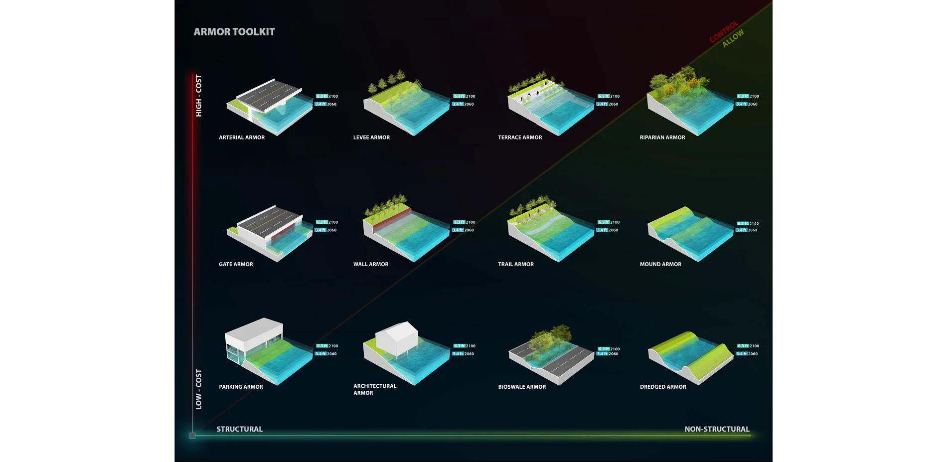
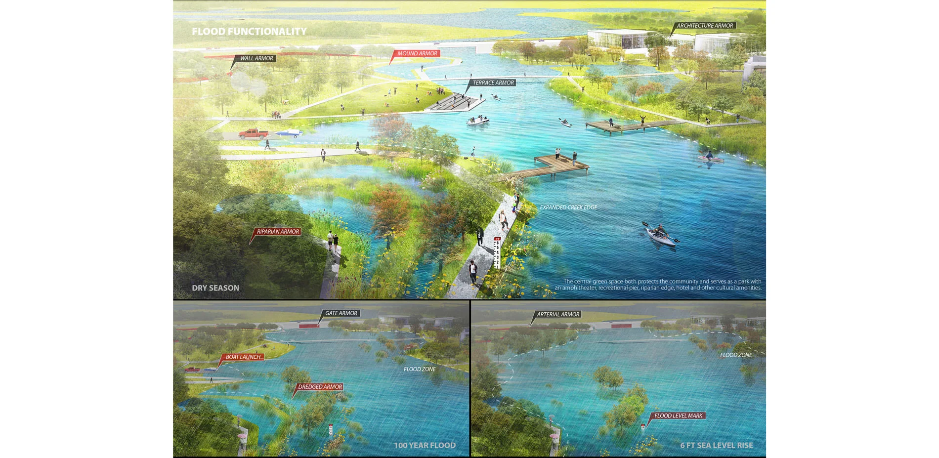
Borrowing from a series of resilient community design cases nationally and internationally, this design develops and incorporates a series of adaptable flood attenuation mechanisms (both structural and non-structural), referred to as the Climate Change Armor Toolkit. Structural mechanisms are engineered infrastructure used primarily to block and control heavy floods. For example: Arterial Armor – an elevated highway which doubles as an integrated flood wall;
- Levee Armor – as gradual and vegetated slope mimicking a natural levee;
- Gate Armor – a sector style mechanism which can close when upstream floods occur;
- Architecture Armor – elevated buildings which are built on stilts.
- Non-structural mechanisms primarily rely on natural systems and green infrastructure to reduce flooding, store stormwater, and soften the potential effects of frequent flooding events. For example:
- Riparian Armor – a collection of preserved and restored wetland areas and vegetated waterfront edges
- Dredged Armor – excavated sediment in strategic locations to store flood water which is reused to increase the elevation of future development;
- Bio-swale Armor – streetscape and urban plaza amenities which convey floodwaters to storage areas and allow for infiltration and filtration of stormwater.
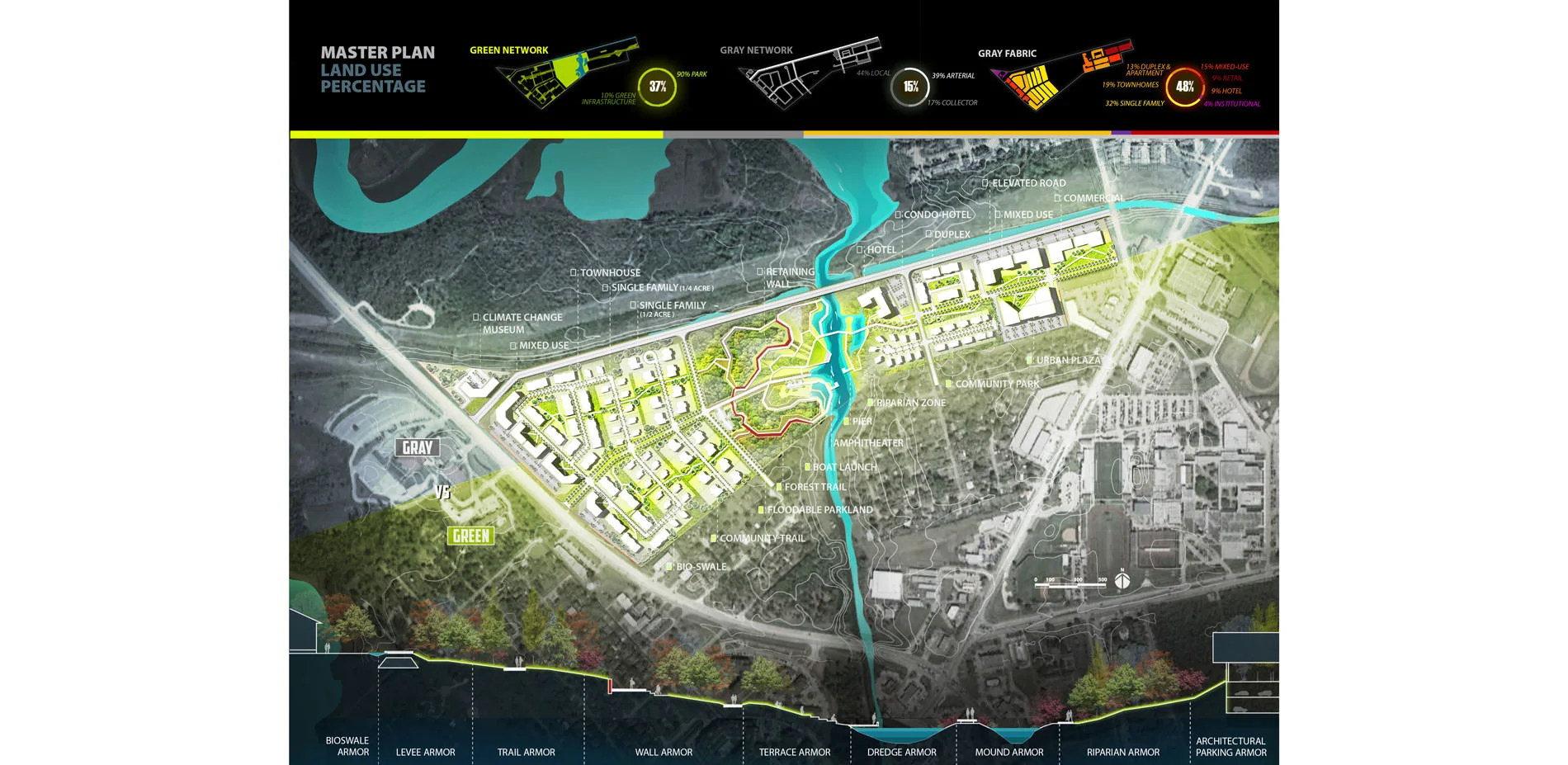
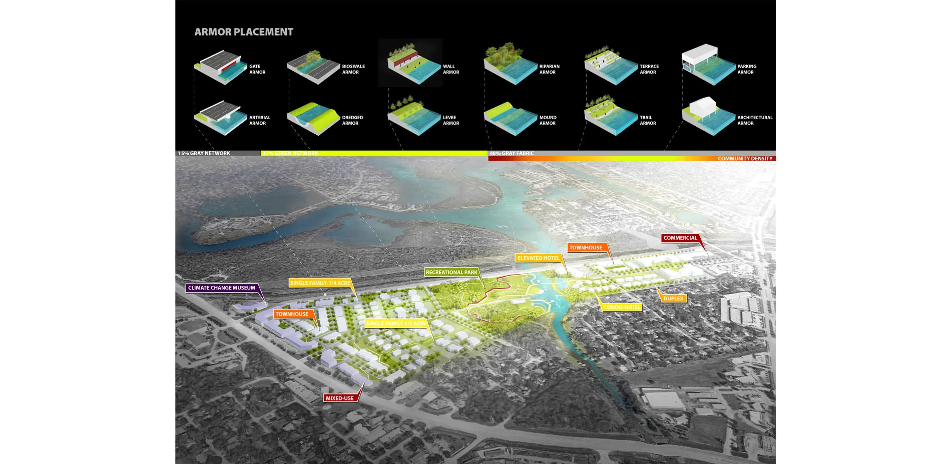
The Climate Change Armor Toolkit’s mechanisms are applied throughout the site, and together compose a solid armor to defend the site from current and future flood issues while simultaneously providing recreational, housing and economic opportunities. The designed green space bordering Clear Creek both protects the community from floods and surge and is designed as a park with an amphitheater, recreational pier, riparian edge, hotel and other cultural amenities. It is connected to the designed green infrastructure system through strategically placed bio-swales, elevated trails and eco-levees; engineered based residential areas, commercial space, and transportation lines also act as multifunctional protective structures to help decrease flood vulnerability.
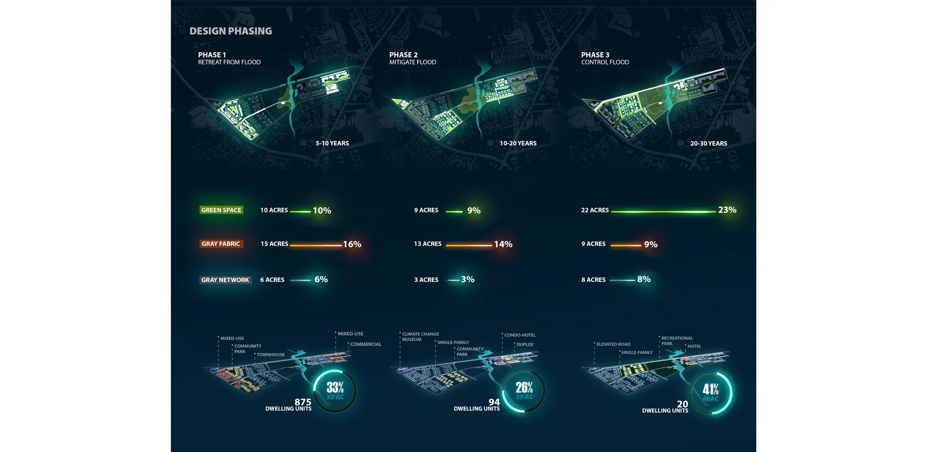
The design is to be implemented in three phases:
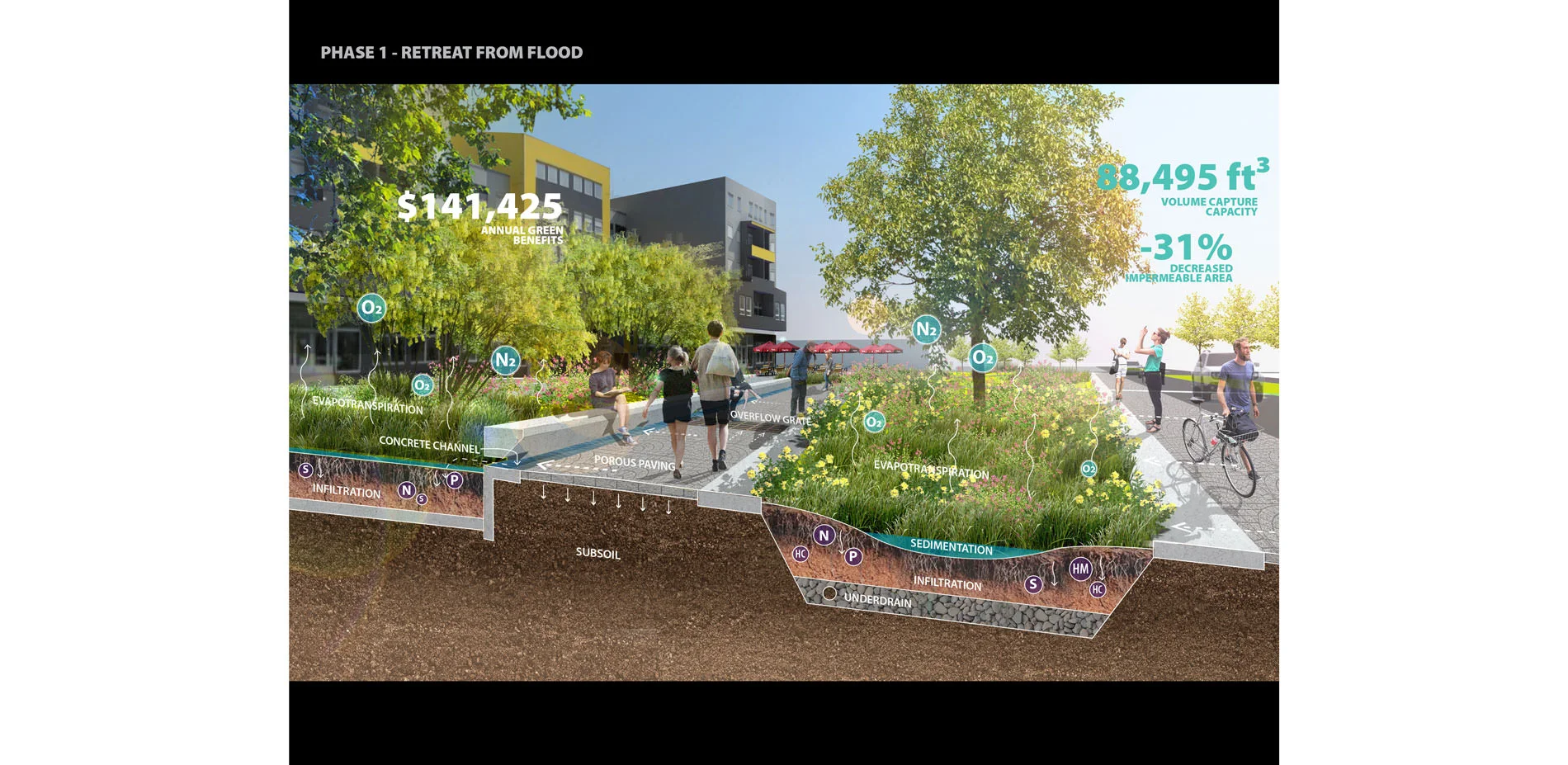
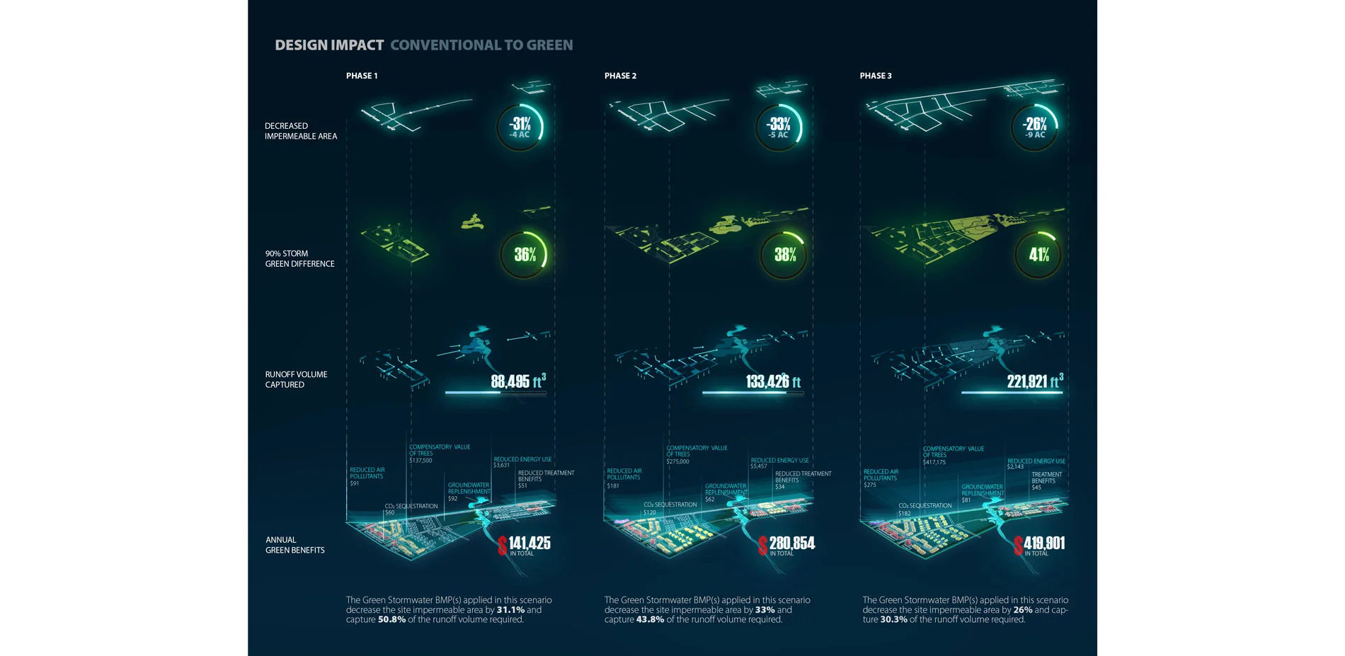
Phase 1) Retreat from flood – focuses on placing development in areas with higher elevation area and integrating green infrastructure.
The designed medium density commercial and mixed-use spaces are connected with existing arterials integrated into the surrounding residence but are strategically placed outside of flood prone areas to limit vulnerability. Public urban spaces with landscape features and permeable paving provide connections to neighbors and promote infiltration, retention, biological treatment, and evapotranspiration processes.
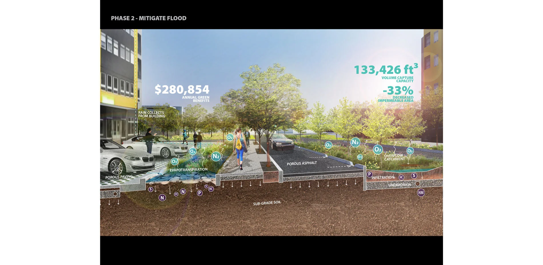
Phase 2) Mitigate flood – develops lower density residences and green infrastructure to provide protection during frequent storms to and gray infrastructure to mitigate larger flood events. Diverse housing types bring in residents from different age groups and backgrounds. New institutional land uses such as a climate change museum provide engaging and educational opportunities for communities.
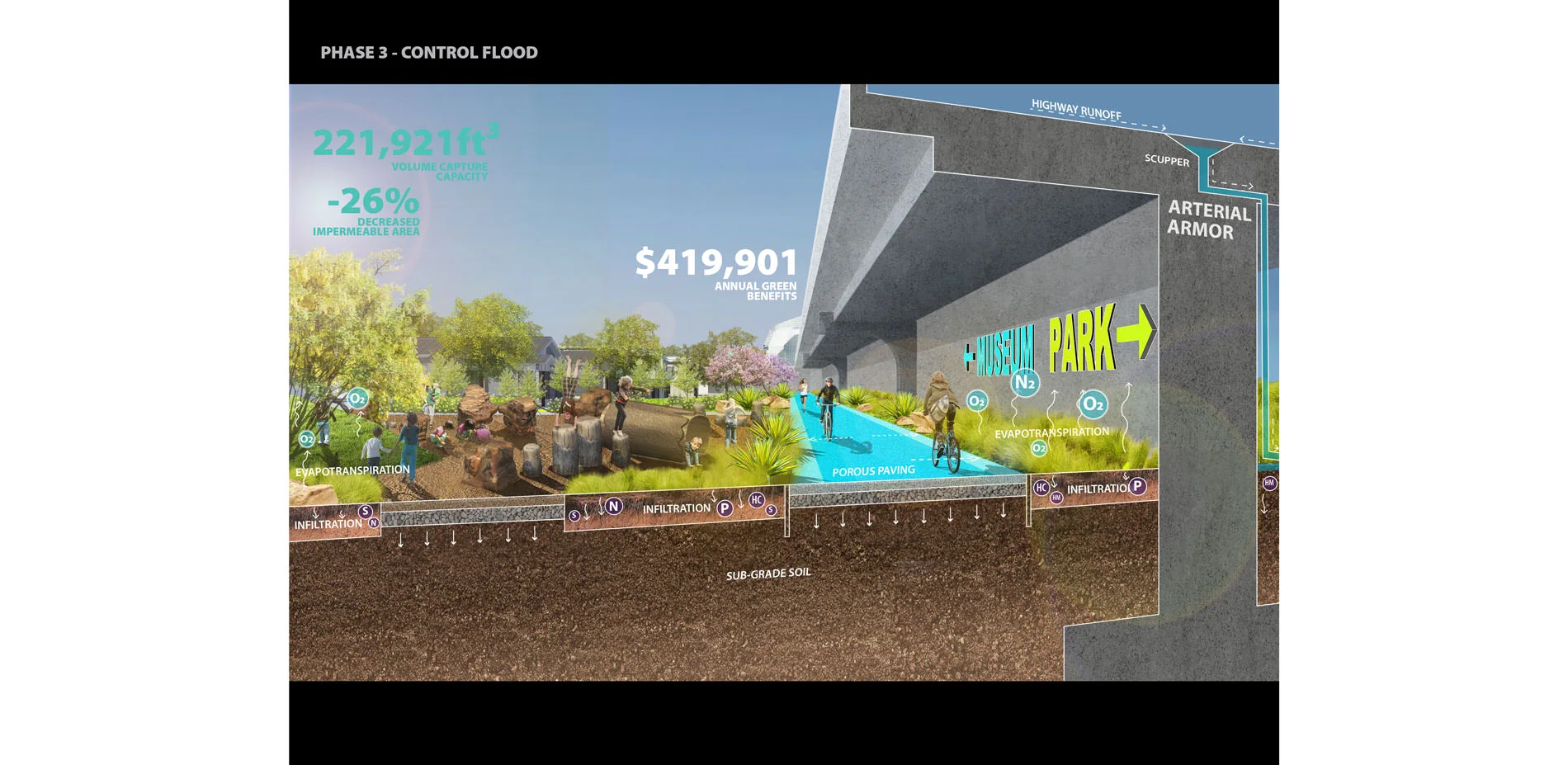
Phase 3) Control flood - completes major installation of structural and gray infrastructure to create a multi-functional armor system that block and control heavy floods and regulate hydrologic activity during extreme hazard events. Simultaneously, an interconnected circulation system including pedestrian trails, boat launch points, pedestrian bridges, and bicycle paths enhance local connection to the waterfront, attract tourists, and create economic opportunities.
Design Impact
The structural and non-structural armor typologies are strategically applied throughout the site into the green and gray network/fabric, to protect residents and deliver valuable both ecological and economic benefits. The National Green Values™ Calculator was used to assess the performance, costs, and benefits of the green infrastructure utilized within the design. Compared with conventional approaches, the Green Stormwater BMP(s) of the design decrease the site impermeable area by 26% and capture 30.3% of the runoff volume required. Simultaneously, the design can capture 221,921 ft3 of runoff, creating $419,901 annual green benefits by reducing air pollutants and energy use, providing pollution treatment, increasing carbon dioxide sequestration, escalating the compensatory value of trees, and improving groundwater replenishment (the economic benefits of these benefits by 2100 reaches $13,305,657).
The Climate Change Armor facilities not only create economic and ecological benefits, but also create enormous cultural and social benefits. With its application, the design decreases the 100-year flood plain by year 2100 with sea level rise from 74 acres to 15 acres (from 76% coverage to only 16%). Also, the nearly 2,400 new residents are protected, over 3,000 jobs are created, around $23 million in physical damage is avoided, and nearly $1.3 billion are generated by the life cycle benefits by 2100.
-
- Mindong Xie
- Chen Ye
Advertisement
Related Awards

Honor Award, Analysis & Planning
A Cultural Approach: The Fort Peck Tribes Hazard Mitigation Plan
In collaboration with the Fort Peck Assiniboine and Sioux Tribes, EPA, and FEMA, the Fort Peck Tribes Hazard Mitigation Plan (HMP) adopts a culturally responsive approach to hazard mitigation planning that features connection to place.

