Disaster Autopsy Model
HONOR
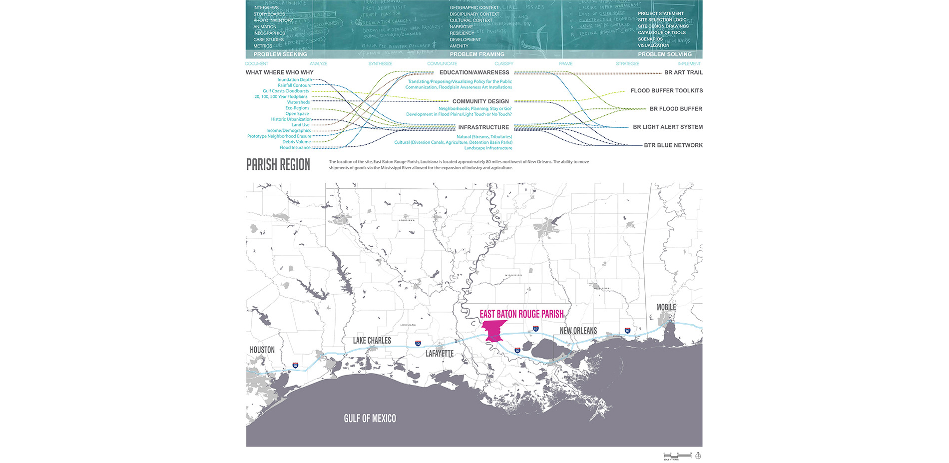
Analysis and Planning
Baton Rouge, LA, USA | Team: Donguk Lee, Student ASLA; Xiwei Shen, Student ASLA | Faculty Advisor: Cathy Marshall
Louisiana State University
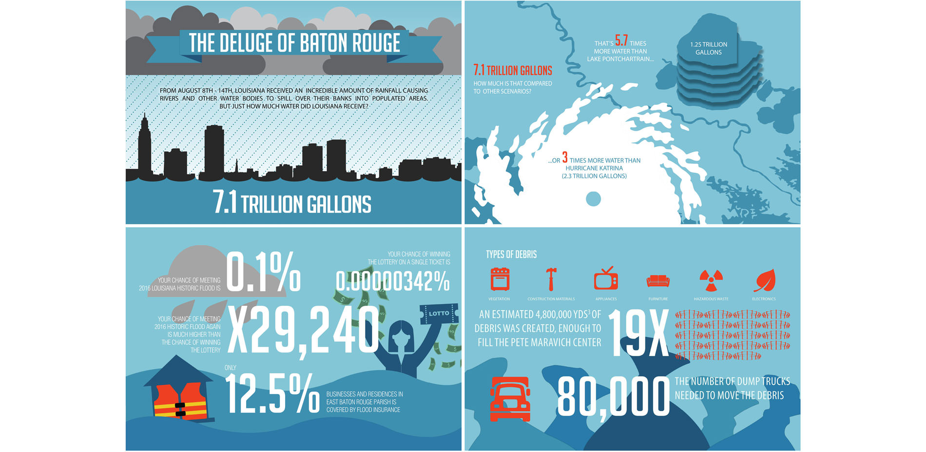
The Deluge of Baton Rouge
Cloudburst event in August 2016 caused catastrophic flooding and dumped the equivalent amount of water as three times that of Hurricane Katrina on east Baton Rouge parish.
Photo Credit: Donguk Lee and Xiwei Shen
Media: Please submit high-resolution image requests to images@asla.org.
Upper: Project work flow. Lower: The storm was seen as a system re-set, allowing elements to be washed away and setting the stage for other latent elements to emerge, multiply and create new configurations.
Photo Credit: Donguk Lee and Xiwei Shen
Media: Please submit high-resolution image requests to images@asla.org.
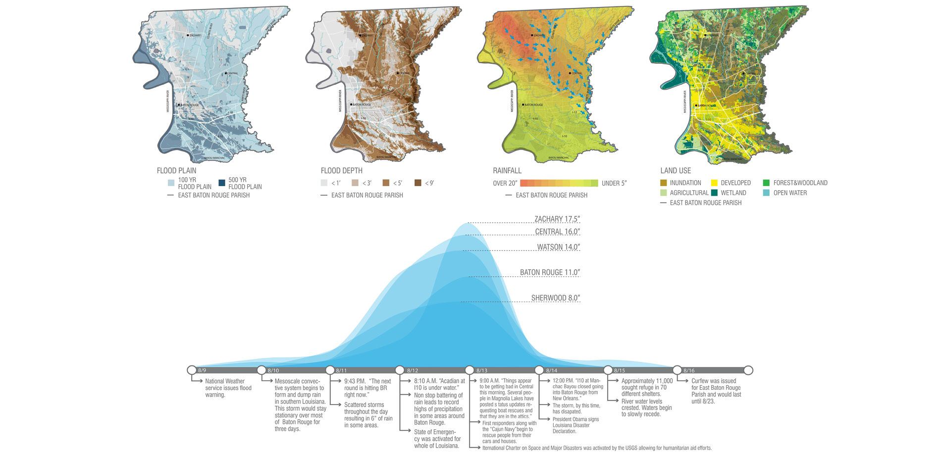
2016 Baton Rouge Deluge
Traditional Mississippi River flood zone mapping in contrast to 2016 Cloudburst event of backflow flooding from Bayous. From August 8th to 14th, 2016 flooding submerged thousands of homes and businesses over the east Baton Rouge parish.
Photo Credit: Donguk Lee and Xiwei Shen
Media: Please submit high-resolution image requests to images@asla.org.
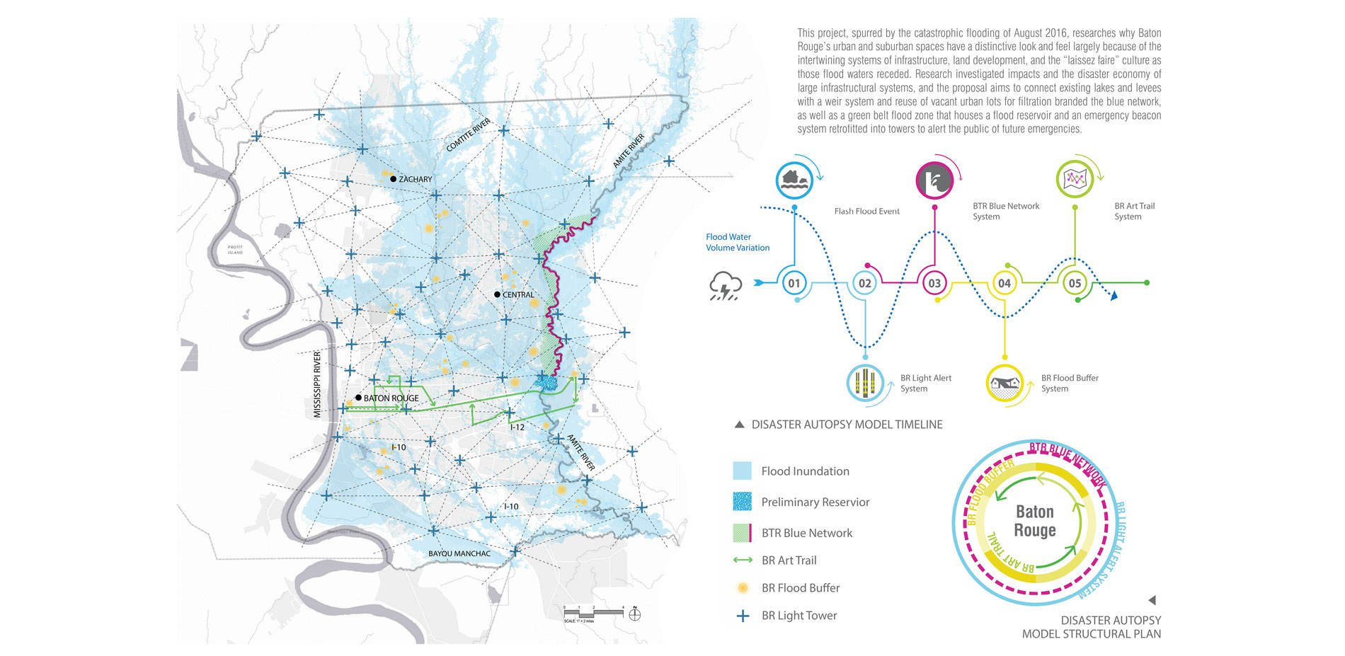
Disaster Autopsy Model
Disaster Autopsy Model: Location of Implementation Projects and Timeline of Responses.
Photo Credit: Donguk Lee and Xiwei Shen
Media: Please submit high-resolution image requests to images@asla.org.
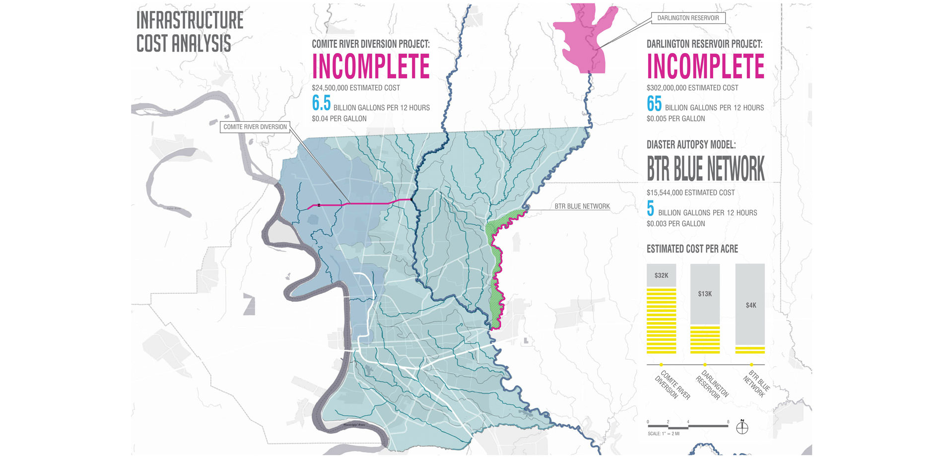
Infrastructure Cost Analysis
Unimplemented Projects vs. Disaster Autopsy Model Cost: The map shows locations of two unimplemented or incomplete engineering works that would have mitigated the flooding and our proposed project that would cost a fraction of the other two.
Photo Credit: Donguk Lee and Xiwei Shen
Media: Please submit high-resolution image requests to images@asla.org.
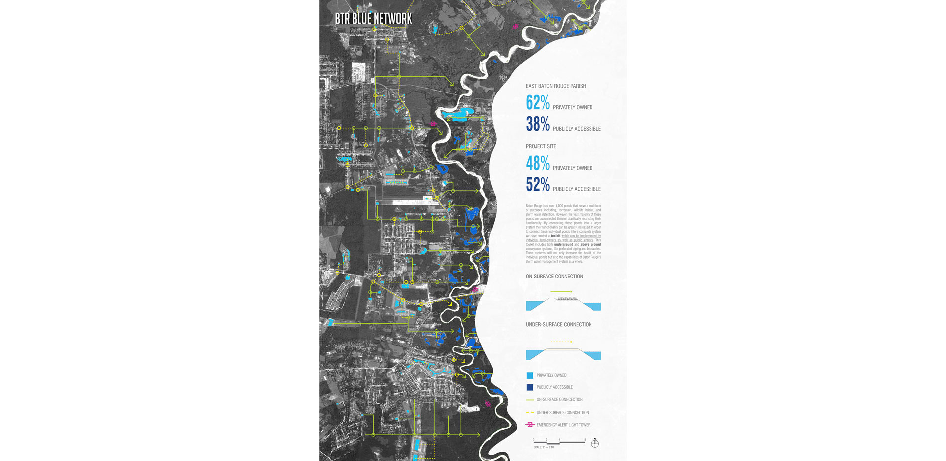
BTR Blue Network
BTR Blue Network: Connecting scattered ponds into a flood mitigation system.
Photo Credit: Donguk Lee and Xiwei Shen
Media: Please submit high-resolution image requests to images@asla.org.
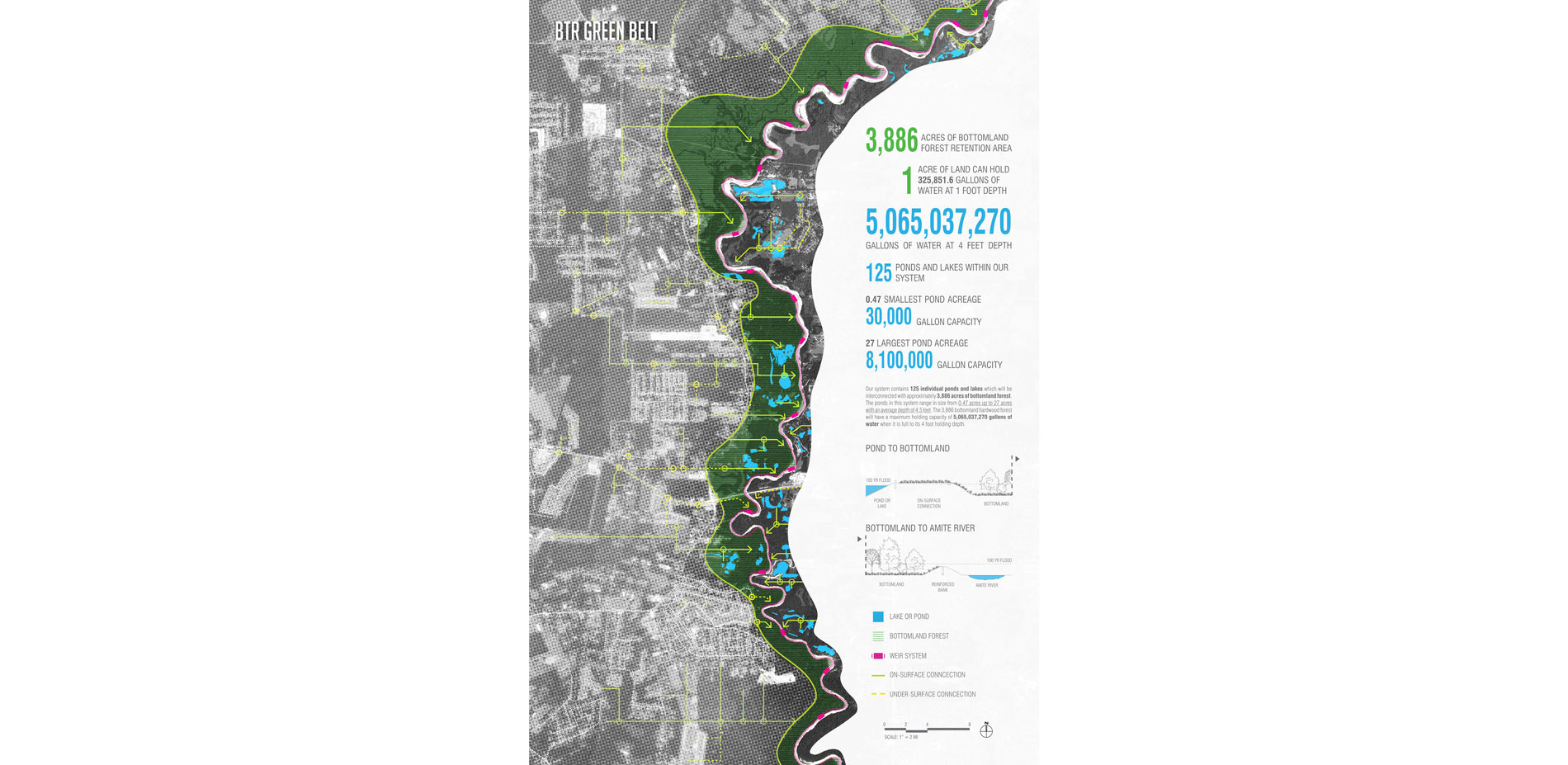
BTR Green Belt:
BTR Green Belt: Creating a bottomland hardwood forest detention basin.
Photo Credit: Donguk Lee and Xiwei Shen
Media: Please submit high-resolution image requests to images@asla.org.
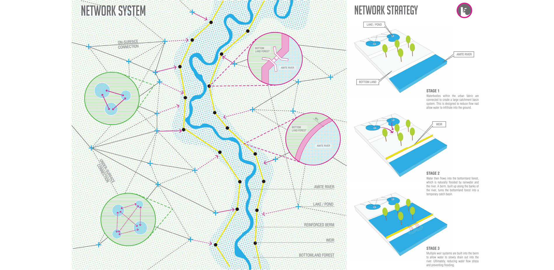
Network System
Multiple weir system allows water to slowly drain into river reducing flood water.
Photo Credit: Donguk Lee and Xiwei Shen
Media: Please submit high-resolution image requests to images@asla.org.
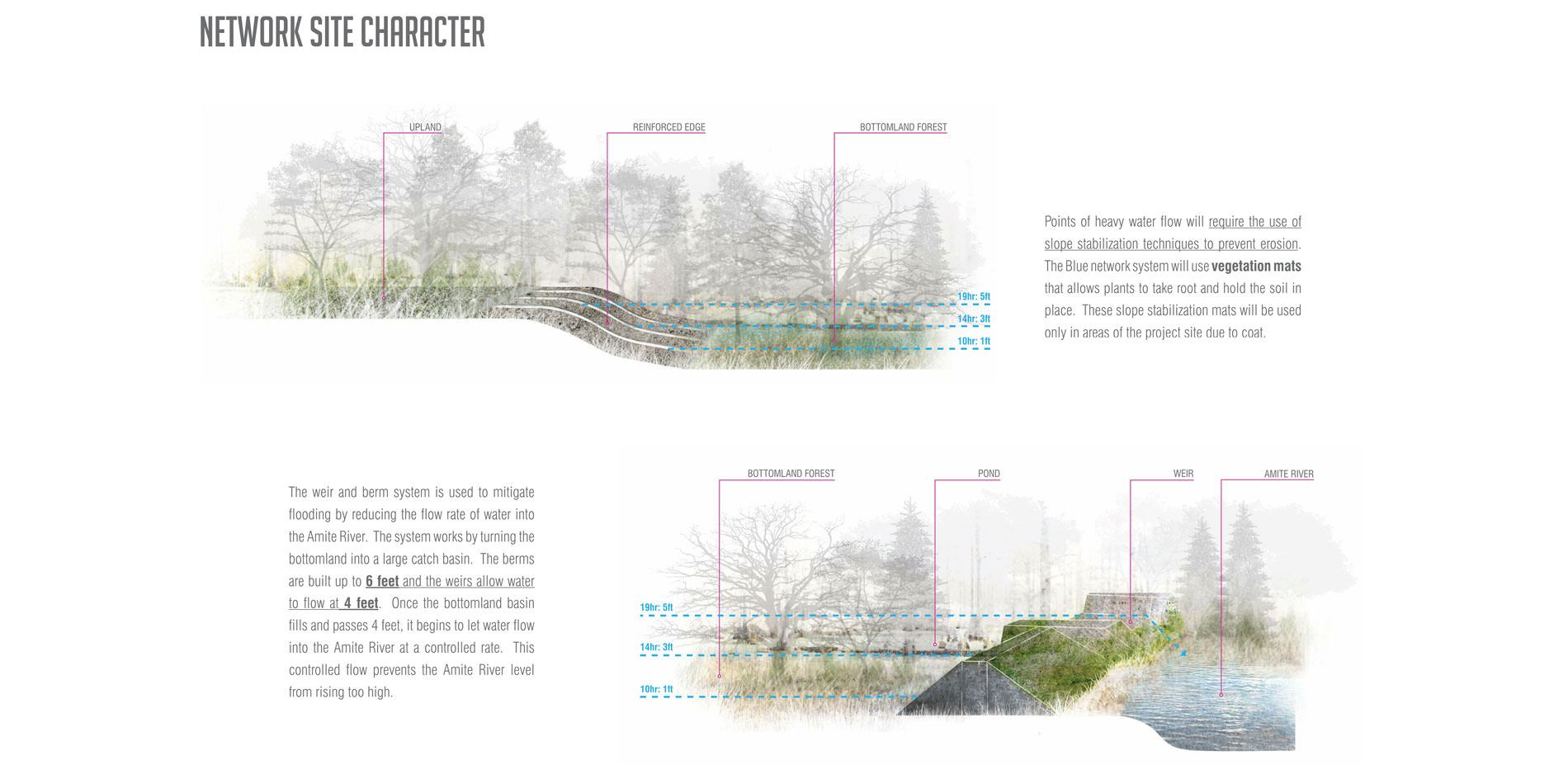
Network Site Character
Vegetation mats promote diverse vegetation to increase habitat, biodiversity and purify stormwater.
Photo Credit: Donguk Lee and Xiwei Shen
Media: Please submit high-resolution image requests to images@asla.org.
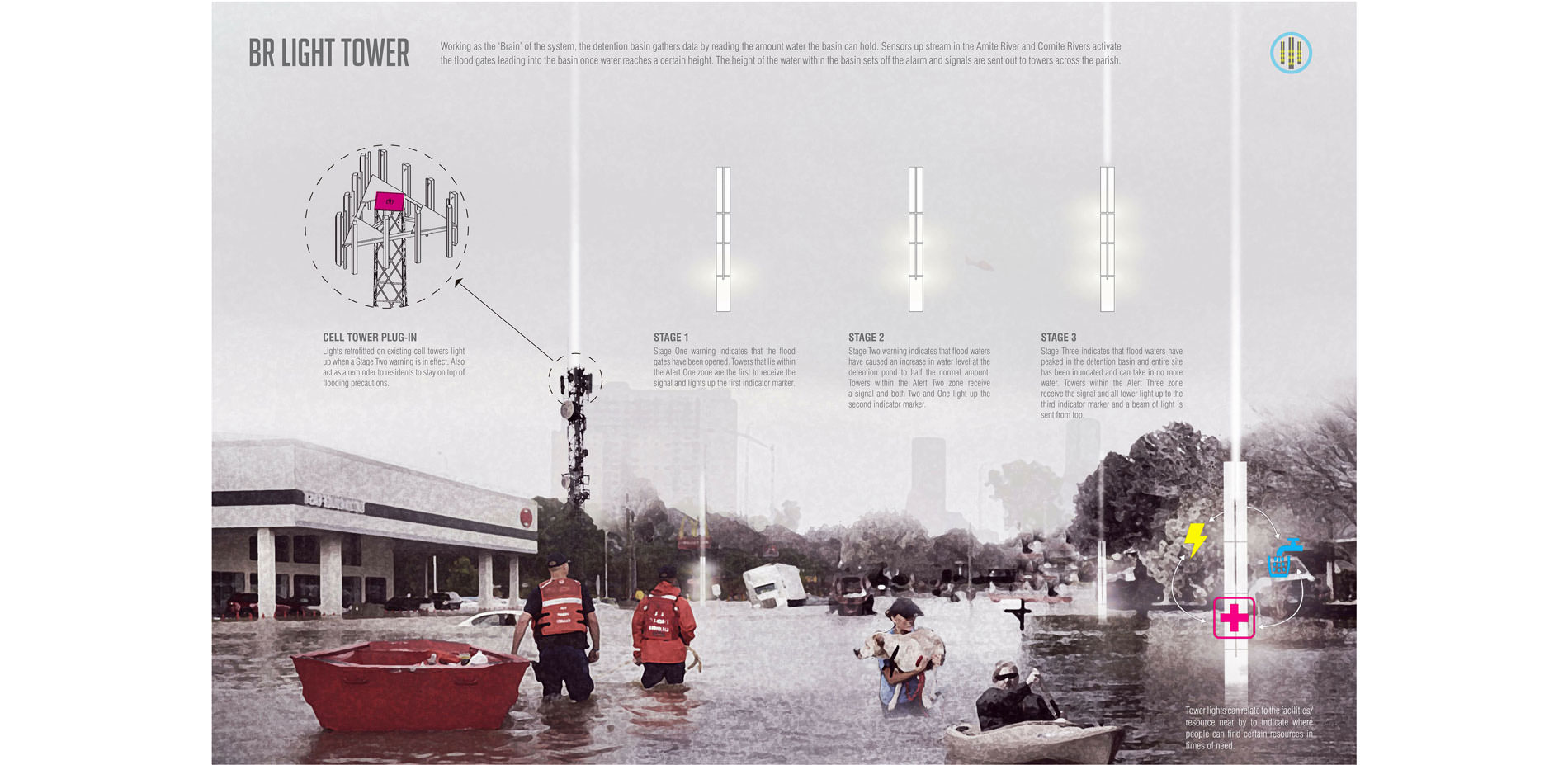
BR Light Tower:
BR Light Tower: A responsive network system that both monitors water levels and provides feedback, emergency alerts, and wayfinding in times of crisis.
Photo Credit: Donguk Lee and Xiwei Shen
Media: Please submit high-resolution image requests to images@asla.org.
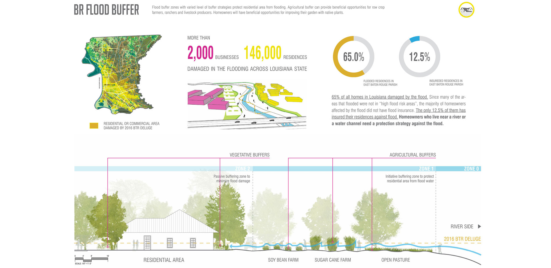
BR Flood Buffer:
BR Flood Buffer: Site-scale strategies.
Photo Credit: Donguk Lee and Xiwei Shen
Media: Please submit high-resolution image requests to images@asla.org.
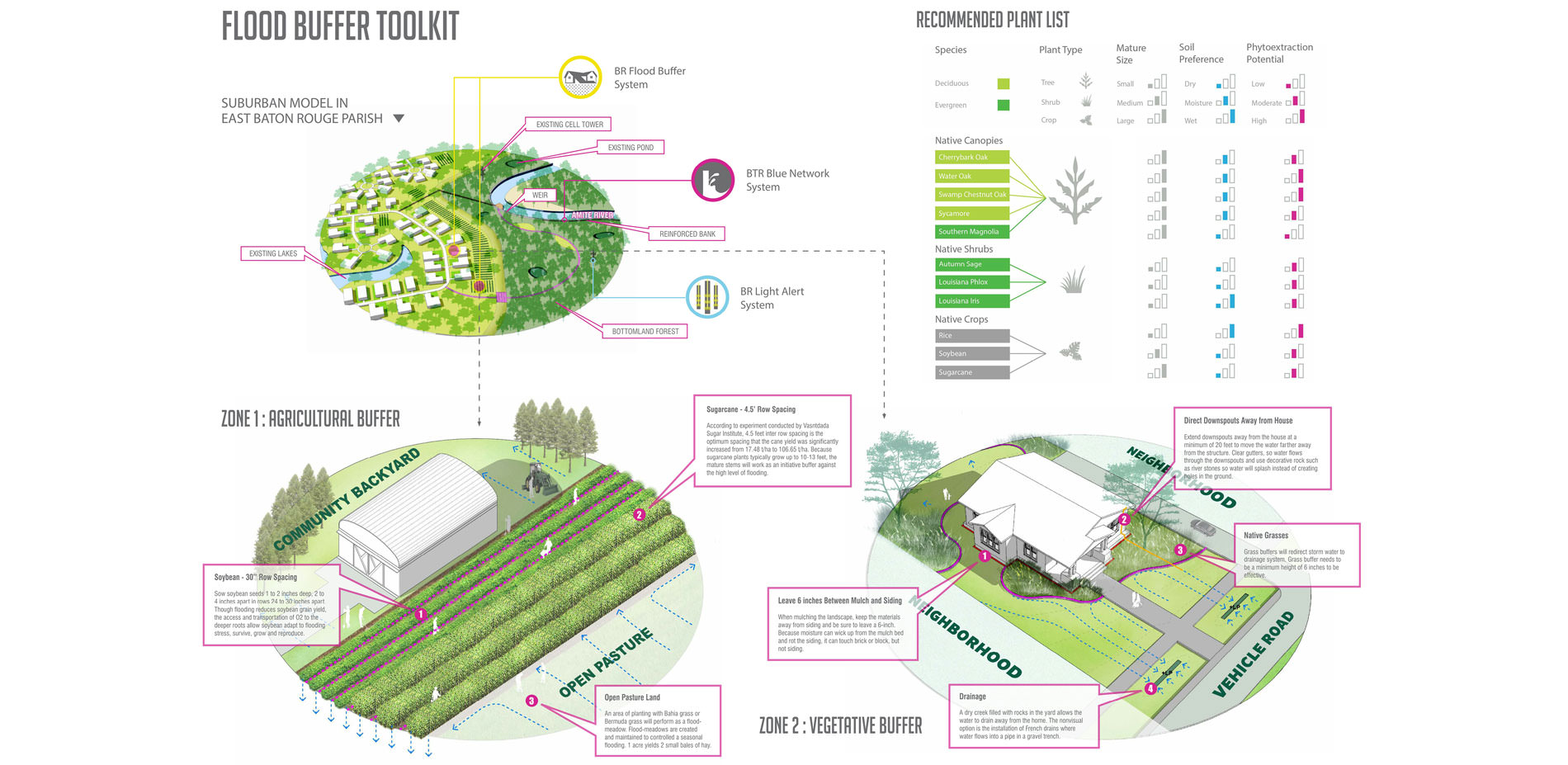
Flood Buffer Toolkit.
Photo Credit: Donguk Lee and Xiwei Shen
Media: Please submit high-resolution image requests to images@asla.org.
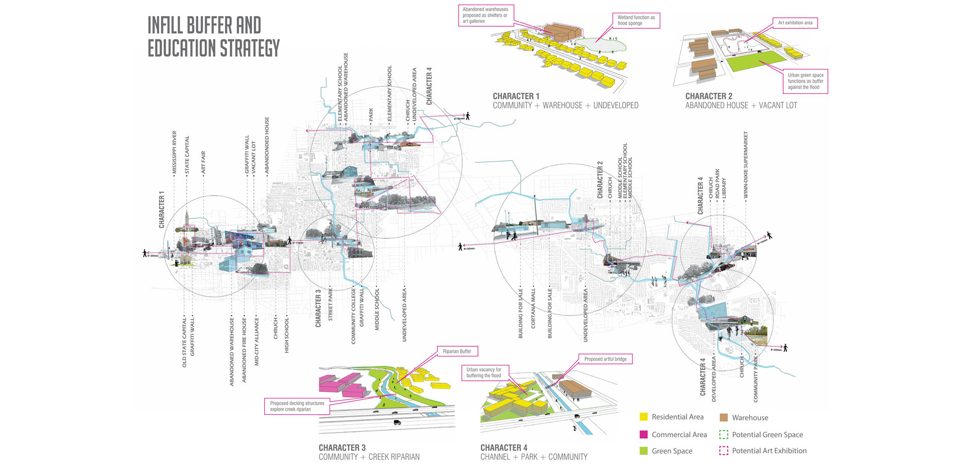
Infill Buffer and Education Strategy Character Typologies.
Photo Credit: Donguk Lee, Xiwei Shen, Yinan Liu, and Yimeng Wang
Media: Please submit high-resolution image requests to images@asla.org.
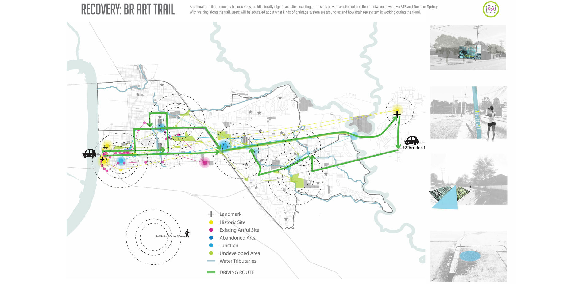
Recovery: BR Art Trail
BR Art Trail connects significant historical and cultural sites while educating users about flood and drainage systems while moving along it, creating awareness and educating simultaneously.
Photo Credit: Donguk Lee and Xiwei Shen
Media: Please submit high-resolution image requests to images@asla.org.
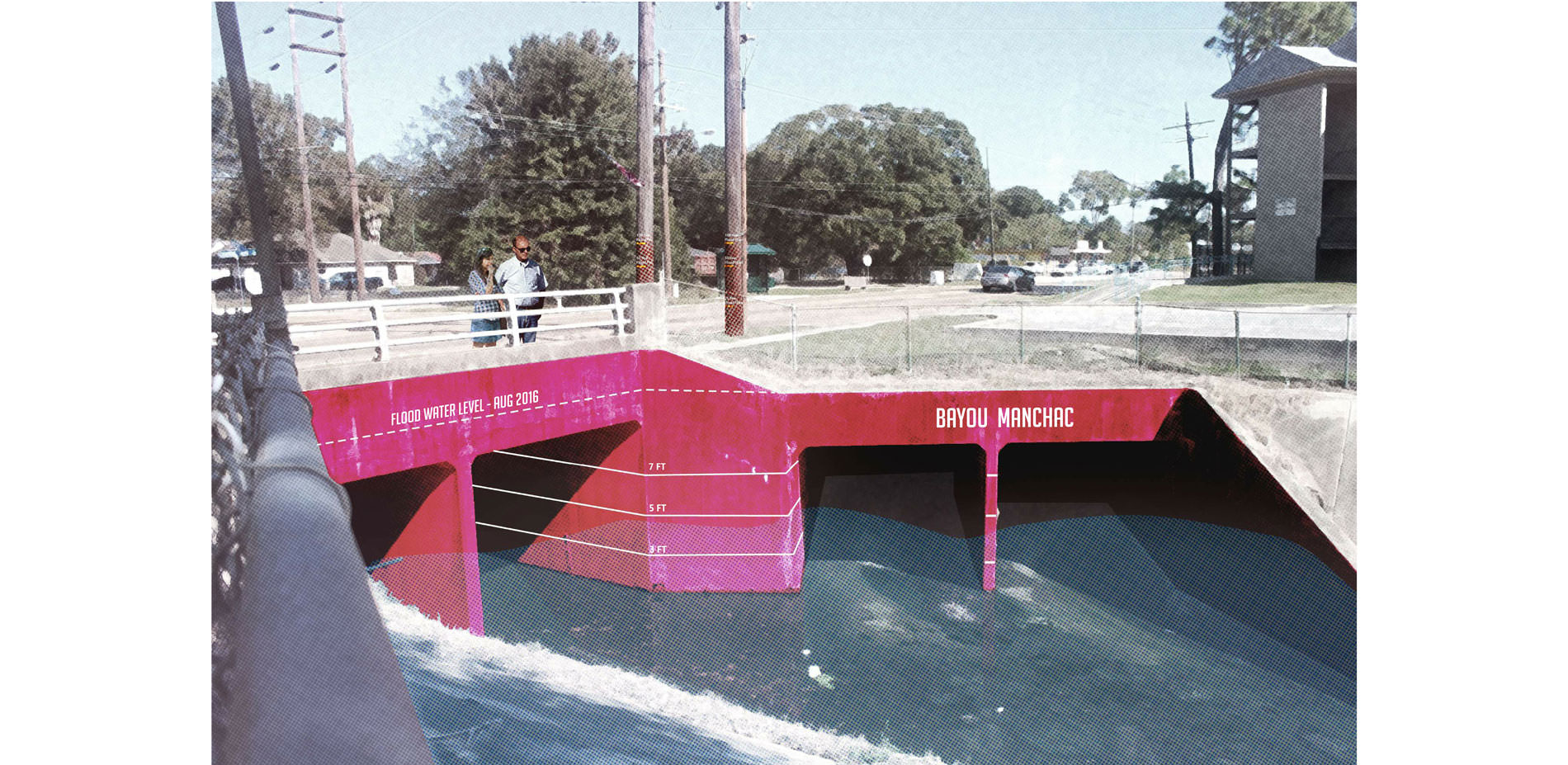
BR Art Trail:
BR Art Trail: Culvert marking.
Photo Credit: Donguk Lee and Xiwei Shen
Media: Please submit high-resolution image requests to images@asla.org.


Strong analysis of the flooding impacts… This project breaks the problem down to little vignettes to give you a sense of how it plays out on the ground.
- 2017 Awards Jury
PROJECT CREDITS
SWA Houston Team
- Kinder Baumgardner, ASLA
- Natalia Beard
- Michael Robinson
- Matt Baumgarten, ASLA
Louisiana State University 2017 Class
- Max Sandlin
- Cody David
- Max Guzzetta
- Yinan Liu
- Yimeng Wang, Student ASLA
- Ethan Nicosia
- Jiaxin Cheng
- Liam Parker
- Ry'yan Clark, Student Affiliate
- Bradley Arabie
- Garrett Jenkins
PROJECT STATEMENT
Water is the heart of Louisiana. Water is why Baton Rouge was founded. Water that moves, water that sits, water that rises, water that cleanses, and water that destroys. Canal water, ditch water, muddy water, spring water, crawfish water, dark water. The history of south Louisiana is a history of man learning to live with water and learning to shape water to our own means.
This project, spurred by the catastrophic flooding of August 2016, researches why Baton Rouge’s urban and suburban spaces have a distinctive look and feel largely because of the intertwining systems of infrastructure, land development, and the “laissez faire” culture as those flood waters receded. Research investigated impacts and the disaster economy of large infrastructural systems, and the proposal aims to connect existing lakes and levees with a weir system and reuse of vacant urban lots for filtration branded the blue network, as well as a green belt flood zone that houses a flood reservoir and an emergency beacon system retrofitted into towers to alert the public of future emergencies.
PROJECT NARRATIVE
On the Gulf Coast, impacts of climate change are most frequently evidenced in flooding caused by hurricanes and sea level rise. However, flooding associated with cloudburst phenomena (sudden, intense rainfall with relatively short notice and duration) is not as documented and understood. The research sought to analyze the phenomena with a cloudburst event and its associated catastrophic flooding that occurred from August 8th to 14th, 2016 over the east Baton Rouge parish. The storm dumped 7.1 trillion gallons of water over the east Baton Rouge area, a volume equal to three times the volume of water that fell during Hurricane Katrina, and almost six times the volume of water contained within Lake Pontchartrain, an inland sea covering an area of 630 square miles north of New Orleans. These cloudburst events, less documented and glamorized in popular media because of their amorphous form and rapid onset, create havoc and destruction as significantly as named storm events such as hurricanes that have a longer preparation time due to named media coverage which captures people’s imagination and fear.
To help mitigate the issue of cloudburst flooding, this project focuses on using existing lakes and levees with a weir system branded the blue network, as well as a green belt flood zone that houses a flood reservoir and an emergency beacon system retrofitted into cell phone towers to alert the public of future events and the reuse of vacant urban lots for water recharge. The design intention is to educate and promote community stewardship, awareness, and responsibility between personal and government.
Prior to the planning and design phase, the what, where, and why of the storm and its aftermath were examined. Site observation of the disaster areas documented what happened and where using video, photography, and interviews with those affected by the flooding. Synthesizing these modes together, a series of maps and diagrams document the timeline, contributing factors, impacts, and relative magnitude of the effects of the storm to tell a story of the human- and natural-induced causes and effects of the storm According to the analysis, the following findings about the Deluge event include that this was not a rare event; an identical storm in 1983 flooded Baton Rouge, but cultural amnesia, lack of political will and lack of money combined to create a lack of response.
These cloudburst storm events exceeded design standards. For example, the 1,000-year floodplain storm event doesn’t get mapped and regulated, yet a category 4 or 5 named hurricane could ultimately be less destructive than a cloudburst based on location, duration, and intensity. The size of this storm overwhelmed the capacity of the sponge landscape to offset flood impacts. And the flood affected higher income households. Thus the study included rethinking the representation of cloudburst events in the media, policy, planning, and design decisions.
During the Study Process, individuals from the Baton Rouge Area foundation, local planners “Center of Planning Excellence”, and landscape architects provided feedback to discuss flooding and resiliency at policy, planning, and detail-level scales to extract, quantify, and create kit-of-part solutions. Identifying three different yet overlapping responses: Infrastructure for emergency storm events; Community Toolkit guidelines for personal stewardship; and Educational Awareness by in-filling vacancies with artful urban runoff filtration enhancing the interconnection of people and water.
In order to respond to future climatic emergency events, this proposal connects scattered ponds into a comprehensive flood reduction system using a combination of above- and below-ground piping, bio swales, and levees and weirs, with amenities designed into the new BTR Blue Network infrastructural system. The Blue Network houses a flood monitoring system and overflow Reservoir at the confluence of the Amite and Comite Rivers that can sense flooding. The monitoring system is linked to a network of existing and proposed towers within communities, providing real-time feedback, power, and wayfinding during extreme events, with the towers serving day-to-day networking and lighting needs.
More than half the homes in the East Baton Rouge Parish flooded in August 2016 with only 12.5% insured; therefore, the Disaster Autopsy Model proposes Flood Buffers that infill urban vacancies responding to property rights. The Flood Buffer Toolkit provides planting strategies for agricultural areas and suburban neighborhoods subject to damage from extreme flood events.
The Flood Buffer suggests four character strategies for existing vacant land to filter urban runoff: character 1 vacant lots and urban warehouse communities to the west, character 2 parks nodes responding to local activities, vacant homes and lots in the suburban east, character 3 and 4 community and tourist aimed water awareness education with mixed use in the center and suburban outskirts. Additionally, the proposal promotes the increase in public education and awareness of significant historical and cultural sites to urban stormwater drainage systems that include curating artful installations that mark features such as: structures, culverts, catch basins and natural and channelized canals.