


Honor Award
Red Mountain / Green Ribbon — The Master Plan for Red Mountain Park
Birmingham, AL
WRT, Philadelphia
Client: Red Mountain Greenway and Recreational Area Commission
 Close Me!
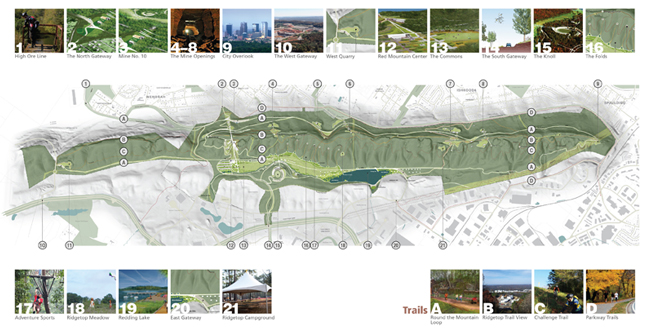
Red Mountain Park. At 1,200 acres, Red Mountain is the largest urban park in the country on land once devastated by mining. It reclaims the landscape and helps heal a distressed community left in the wake of industrial decline.
Download Hi-Res ImageImage: Wallace Roberts & Todd, LLC
Image 1 of 16
 Close Me!
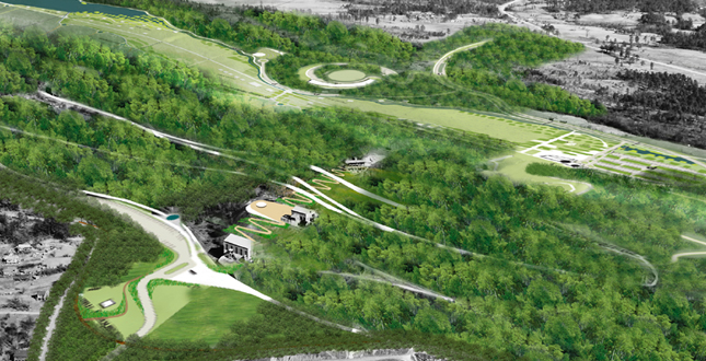
From Bare Rock to Green Ribbon. Five Miles of Mountain Parkland in the city: Red Mountain Park is six miles from downtown Birmingham, within city limits, and adjacent to very dense neighborhoods that served the miners and blast furnaces.
Download Hi-Res ImageImage: Wallace Roberts & Todd, LLC
Image 2 of 16
 Close Me!
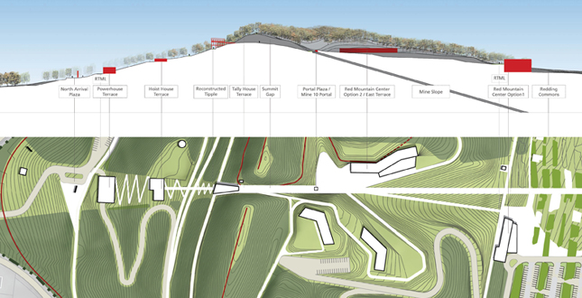
Design Foundation. The physical expression of iron are mining shapes the park. The points, lines and planes formed by portals, shafts and underground mine patterns organize the park, linking past industry to present recreation, and subterranean to surface.
Download Hi-Res ImageImage: Wallace Roberts & Todd, LLC
Image 3 of 16
 Close Me!
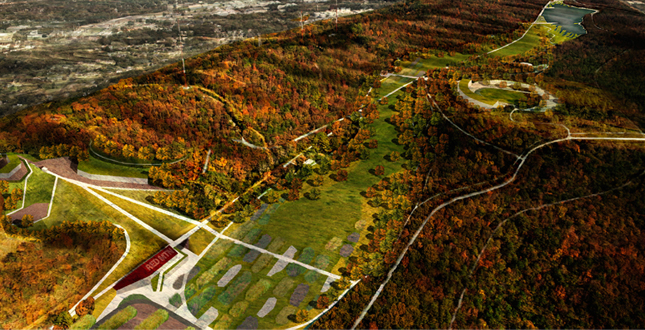
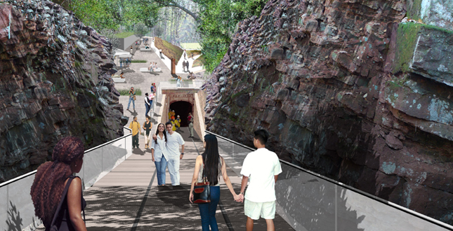
The Industrial Wild. Once a haulage trail for iron are now reclaimed by successional vegetation, the Mine 10 cut will be repurposed to connect both sides of the mountain and create a central armature of experience.
Download Hi-Res ImageImage: Wallace Roberts & Todd, LLC
Image 4 of 16
 Close Me!
A Mountain Mine Journey The Mine 10 cut is part of a larger half mile journey following the alignment of the mine shaft, parking, visitor centers, exhibits, and the Redding Commons lawn will flank the Over the Mountain trail.
Download Hi-Res ImageImage: Wallace Roberts & Todd, LLC
Image 5 of 16
 Close Me!
Hybrid Topographies. Red Mountain is an express both of geologic and human processes and these in turn organize the design of the park. On the southern face, existing mining terraces are sculpted to provide areas for gathering and interpretation.
Download Hi-Res ImageImage: Wallace Roberts & Todd, LLC
Image 6 of 16
 Close Me!
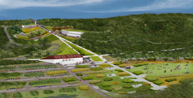
A Terrace in the Trees. The largest of the terraces, where the Mine 10 shaft emerges, will be the location of the Portal Plaza. This seven acre plaza will be a large gathering space for weddings and events.
Download Hi-Res ImageImage: Wallace Roberts & Todd, LLC
Image 7 of 16
 Close Me!
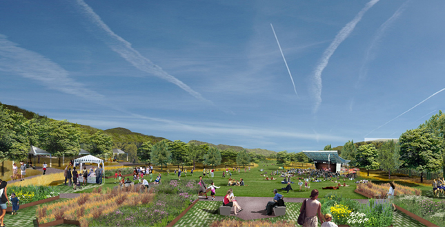
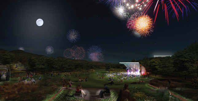
An Escape in the Valley. The Over the Mountain Trail leads visitors to Redding Commons, the primary location for park recreational functions. Enclosed by Red Mountain and Sand Ridge, the Commons provides complete immersion in the park experience.
Download Hi-Res ImageImage: Wallace Roberts & Todd, LLC
Image 8 of 16
 Close Me!
Connecting to the Community. The northern segment of the Over the Mountain trail connects the park to the former mining communities of Red Mountain. Pavilions at the locations of former mining structures provide areas for picnicking, interpretation, and play.
Download Hi-Res ImageImage: Wallace Roberts & Todd, LLC
Image 9 of 16
 Close Me!
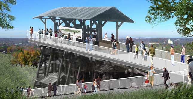
A Projected Perspective. The Mine No. 10 Tipple will be reconstructed as a dramatic overlook. Visitor will see the neighborhoods to the north, the former ore furnaces in the distance, and place themselves within the city of Birmingham.
Download Hi-Res ImageImage: Wallace Roberts & Todd, LLC
Image 10 of 16
 Close Me!
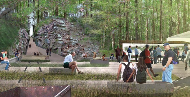
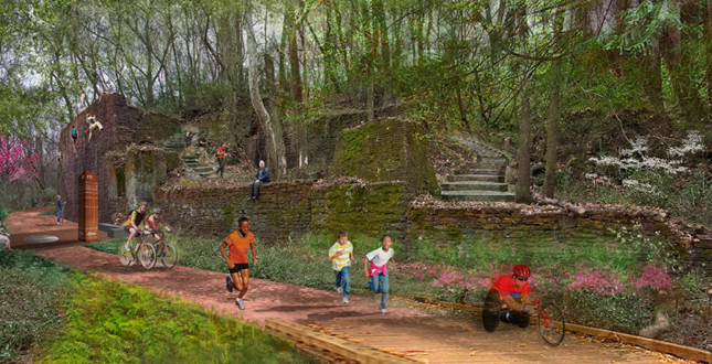
Machines in the Garden. The north face of the mountain is punctuated with the poetic presence of nine complexes of mine portals, stone, concrete and brick foundations. These will become activity centers for interpretation, picnicking, climbing and concessions.
Download Hi-Res ImageImage: Wallace Roberts & Todd, LLC
Image 11 of 16
 Close Me!
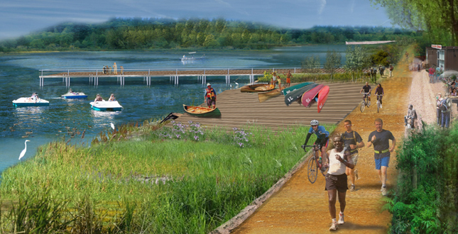
The Experience of Water. A new dammed lake will include gathering spaces with a food concession, canoe rentals, and picnic areas, serving as a water activity hub in a city noted for its lack of large water bodies.
Download Hi-Res ImageImage: Wallace Roberts & Todd, LLC
Image 12 of 16
 Close Me!
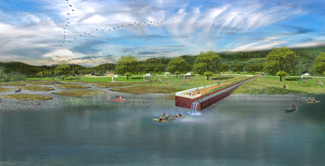
A Lake with a Different Dimension. The lake edge will be bio-engineered with wetland islands patterned after the subterranean mining passages. The Mine 11 pier expresses the mine shaft beneath and acts as a viaduct for stormwater management.
Download Hi-Res ImageImage: Wallace Roberts & Todd, LLC
Image 13 of 16
 Close Me!
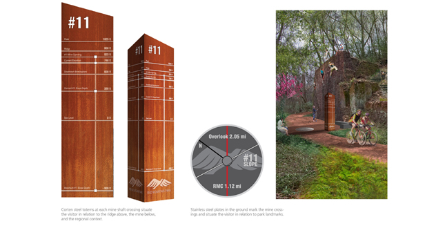
Marketing the Land: Iron Totems & Steel Discs. Totems and ground markings along the Round the Mountain Loop located at each mine slope crossing will situate visitors within the park as well as within their geologic, historic, and temporal contexts.
Download Hi-Res ImageImage: Wallace Roberts & Todd, LLC
Image 14 of 16
 Close Me!
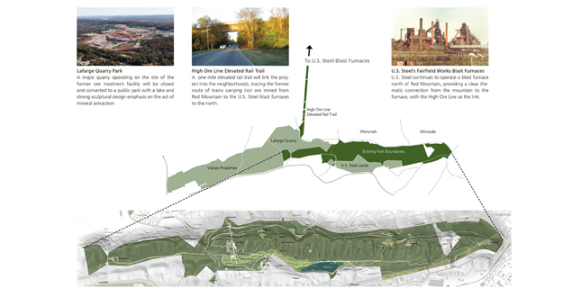
A Park Without Borders: Partnership & Outreach. The Park will expand over time to include adjacent elevated rail-to-trail corridor, a major quarry, adjacent ridgetop land, and “offset development” parcels. Adjacent communities to the north will benefit from revitalization planning.
Download Hi-Res ImageImage: Wallace Roberts & Todd, LLC
Image 15 of 16
Project Statement
Red Mountain Park is the largest urban park in the country reclaimed from a landscape devastated by a century of mining. Located along a ridgeline on the edge of the city, the 1200-acre park will connect the new and old Birmingham — revitalizing the long-disadvantaged northern community left in the wake of mining. Referred to in the press as the Great Divide, the mountain is a vestigial symbol of the city’s formerly divisive historic racial and economic conditions. The park will bridge the two communities, linking the older historically African American communities to newly developing communities on the other side of the mountain.
Project Narrative
—2012 Professional Awards Jury
When complete the park will change people’s minds about the long lost landscape, creating a type of community therapy via recreation. Features include over 40 miles of trails with a 10-mile rail trail and a 4-mile highline trail on elevated rail grade, a 45-acre commons, a 20-acre lake, and various active adventure recreation areas. In addition, nine historic mine openings will be interpreted, with one mine as the park’s interpretive and development focus. Reaching well beyond the park boundary to connect to and secure the future stability of the adjacent communities via greenway links, the project helps to improve both the long-term sustainability of the site and the larger community.
A redemption story in the making, the park will anchor Birmingham’s new green infrastructure, and spur associated economic spinoff in a region much in need of a civic “victory.” The park will play a central role in helping Birmingham reconcile its proud and complex history, and move on from its dual identity as epicenter of civil rights struggle and former iron making giant.
Six themes organize the program and layout of the park: Vitality (public health and recreation), Heritage (industrial history), Renewal (environmental restoration), Connection (greenway and community links), Partnership (neighborhood revitalization, new development partnerships), and Management (stewardship and green building/operations).
Environmental Sustainability is demonstrated by the protection of the parkland from private development. The Renewal Theme includes plans for long-term forest and habitat management, reclamation of disturbed mined areas. The Management Theme employs bioengineering techniques to highlight upper watershed water quality improvement, invasive species removal (kudzu and Chinese Privet), transmission line eco-management plan, and commitment to LEED and Sustainable Sites Initiative standards for new construction.
Social Sustainability is demonstrated by four themes: the Vitality Theme enhances public health through active recreation, the Heritage Theme bolsters community identity, and the Connection and Partnership Themes secure social equity. The healing process is begun by using the park to link two very different communities divided by the mountain even prior to the mid-19th Century onset of mining. The division was accentuated as the northern communities, company towns developed by the mining company, struggled with mine closings in the mid-19th century. These historically black communities have subsisted in the mountain’s shadow, with no relationship to the vast abandoned mine lands (private corporate holdings sealed to public access). In contrast, the southern communities represent the region’s most ambitious growth: golf courses, signature hotel, planned communities, and office parks define a lifestyle far removed from the northern communities. The Master Plan expresses the client’s desire to use park planning, physical design, and programming to break the barriers and to organize a neighborhood stabilization, historic preservation, and improvement plan in response to the new park. Cultural heritage is vital to preserving community identity of the former company towns still inhabited by original miners and their descendants.
Economic Sustainability is demonstrated by the Partnership and Management themes. The client is exploring a park-related development such as a hotel or conference/retreat on a key site within the park. Adjacent lands with strategic economic value are under consideration for acquisition as park revenue-generators, to assure the park’s long-term viability and provide a revenue stream to accelerate construction of capital improvements. Several opportunities for park-specific revenue include a sliding-scale gate fee, rentals, and equipment, tour and food concessions. The effect on the northern communities is viewed as having a strong increase in property values, providing additional spinoff retail opportunities and, in concert with a local community college, a park operations employment training program. An economic impact report projects significant regional impact from these cumulative efforts, and an increase in adjacent land values commensurate with John Crompton’s proximate value principle.
Environmental and Social Data Collected and Analyzed
The client and landscape architect developed a broad public engagement campaign to gain knowledge of the environmental, cultural and social conditions, and to lay the groundwork for consensus of the wide range of stakeholders. Local residents, public officials, arts, civic advocates, educators, health professionals, law enforcement, disabled persons, religious leaders, and business leaders participated in the workshops. Panels of experts — ecologists, geologists, recreation interests, and historians — also participated. Based on the interviews, focused environmental data was derived from county GIS mapping, the archives of U.S. Steel, a previous heritage area documentation including HABS HARE records, exhaustive cultural resource-mapping project, and a targeted bio-inventory.
Methods of Analysis
Data was compiled in a series of inventory maps presented for review and contribution at an open public meeting, stakeholder meetings, and key issue focus groups. Future tasks such as a bioblitz and detailed cultural resource documentation efforts were recommended to fill in the gaps. The outcome of the inventory placed a high value on the mine infrastructure as the defining feature, supported by the environmental context of deciduous forest that has substantially reclaimed the mine lands.
How Options Were Considered
With the major decision to create the park already in place, a “foundation plan” laid out common elements with universal appeal. Facilitated public meetings were conducted to review the foundation plan and determine the preferred additional elements.
How Interested Parties Participated in the Project
The Steering Committee, including stakeholder group leaders (community stakeholder groups, focused topic specialists, general community support via the Friends of Red Mountain Park, and a dedicated My Space community) all enriched the process.
The Role of Design in Project
Design transforms a hidden archaeological relic into a vital, living attraction. The design extends the underground mine geometry to the surface, providing the basis for the vectors and patterns that shape park circulation and features. Strong compositions re-position the cultural resources (mines, railroads) as focal points of recreation and touchstones of history. The intent is to shape a positive and transformative image for an abused landscape both to inspire public interest and catalyze fundraising.
How the Project Will Be Implemented
A $30 million first phase will kick off implementation, based on a patchwork of funding from private corporations, city, county, state, federal and nonprofit granting entities. Future phase implementation will depend on collateral development revenue and future allocations and donations. Detailed cultural and natural resources investigations and oral history interviews with miners are in progress now, and volunteers have begun building trails and removing invasive vegetation.
How the Project Will Be Administered
Following its birth, first under the auspices of U.S. Steel and then a steering committee, legislation established a governing commission to oversee the land as a state recreational area and greenway. A park friends group and a non-profit fundraising arm support the commission.
Project Resources
Wallace Roberts & Todd
Principal in Charge: Eric Tamulonis ASLA
Consulting Principal: Elizabeth Clarke
Senior Planner: Michael Clarke
Landscape Architect: Douglas Meehan
Client: Freshwater Land Trust
Wendy Jackson
Client: Red Mountain Recreational Area and Greenway Commission
David Dionne
Community Engagement and Logistics: Clarus Consulting
Cultural Resource Consulting: Richard Anderson
Initial Park Concept Plan: Nimrod Long Associates
Economic Impact Assessment: ConsultEcon